Workshop on electronic technologies for fisheries - STUDY Requested by the PECH Committee - European ...
←
→
Page content transcription
If your browser does not render page correctly, please read the page content below
STUDY
Requested by the PECH Committee

                   Workshop on
                    electronic
                 technologies for
                     fisheries
             Part I: Transmitted positional data
                           systems

               Policy Department for Structural and Cohesion Policies
                       Directorate-General for Internal Policies
                             PE 652.254 - October 2021
                                                                        EN
RESEARCH FOR PECH COMMITTEE

       Workshop on
        electronic
     technologies for
         fisheries
Part I: Transmitted positional data
              systems
Abstract
This study is the first research paper in a series of three, prepared
for a PECH Committee Workshop. It reviews the state of the art of
transmitted positional data systems, high resolution and
synthetic aperture radar (SAR) for satellite image data used in
fisheries control and fisheries research. It identifies the strengths
and weaknesses of such systems and provides policy
recommendations for a more effective fisheries control system
based on currently applied electronic technologies (ET).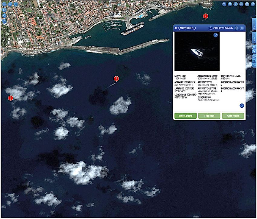
This document was requested by the European Parliament's Committee on Fisheries.
AUTHOR

AZTI Marine Research Department: Iñaki QUINCOCES

Research administrator: Marcus BREUER
Project, publication and communication assistance: Jana BERGMAN, Kinga OSTAŃSKA, Thaya Mirinda
DINKEL (trainee)
Policy Department for Structural and Cohesion Policies, European Parliament

LINGUISTIC VERSIONS

Original: EN

ABOUT THE PUBLISHER

To contact the Policy Department or to subscribe to updates on our work for the PECH Committee
please write to: Poldep-cohesion@ep.europa.eu

Manuscript completed in July 2021
© European Union, 2021

This document is available on the internet in summary with option to download the full text at:
https://bit.ly/3lgWJ09

This document is available on the internet at:
http://www.europarl.europa.eu/thinktank/en/document.html?reference=IPOL_STU(2021)652254

Further information on research for PECH by the Policy Department is available at:
https://research4committees.blog/pech/
Follow us on Twitter: @PolicyPECH

Please use the following reference to cite this study:
Quincoces, I 2021, Research for PECH Committee – Workshop on electronic technologies for fisheries -
Part I: Transmitted positional data systems, European Parliament, Policy Department for Structural and
Cohesion Policies, Brussels
Please use the following reference for in-text citations:
Quincoces (2021)

DISCLAIMER

The opinions expressed in this document are the sole responsibility of the author and do not
necessarily represent the official position of the European Parliament.

Reproduction and translation for non-commercial purposes are authorized, provided the source is
acknowledged and the publisher is given prior notice and sent a copy.
© Cover image used under the licence from Adobe Stock
IPOL | Policy Department for Structural and Cohesion Policies

CONTENTS
LIST OF ABBREVIATIONS                                                                                      5
LIST OF FIGURES                                                                                            7
LIST OF TABLES                                                                                             7
EXECUTIVE SUMMARY                                                                                          9
1.   STATE OF PLAY OF TRANSMITTED POSITIONAL DATA SYSTEMS                                                 12
     1.1. Global Navigation Satellite Systems                                                             13
     1.2. NAVSTAR Global Positioning System                                                               15
           1.2.1. GALILEO                                                                                 17
           1.2.2. Other GNSS systems                                                                      18
     1.3. Marine monitoring solutions based on GNSS data                                                  18
           1.3.1. Vessel monitoring system                                                                18
           1.3.2. Automatic identification system                                                         18
     1.4. Marine monitoring solutions based on satellite remote sensing (SRS)                             20
           1.4.1. Very high resolution remote sensing                                                     20
           1.4.2. Synthetic aperture radar                                                                21
2.   CURRENT APPLICATIONS USING TRANSMITTED POSITIONAL DATA SYSTEMS                                       23
     2.1. Applications using a vessel monitoring system                                                   23
           2.1.1. The EU vessel monitoring system for fisheries control.                                  23
           2.1.2. The US vessel monitoring system for fisheries controls                                  25
           2.1.3. Use of VMS data in fisheries science in the EU                                          26
           2.1.4. Use of VMS data in fisheries science in the United States of America                    29
     2.2. Applications using an automatic identification system                                           29
     2.3. Applications using satellite remote sensing                                                     31
           2.3.1. European Maritime Safety Agency - Copernicus Maritime Surveillance                      31
     2.4. Applications combining different data sources                                                   34
           2.4.1. EMSA Copernicus Maritime Surveillance – Vessel Correlation Service                      34
     2.5. Private companies offering applications using satellite remote sensing (SRS)                    35
3.   BENEFITS AND RISKS OF TRANSMITTED POSITIONAL DATA SYSTEMS                                            37
     3.1. Vessel monitoring system                                                                        38
           3.1.1. Strengths of VMS                                                                        38
           3.1.2. Weaknesses of VMS                                                                       38
     3.2. Automatic identification system                                                                 39
           3.2.1. Strengths of AIS                                                                        39

                                                    3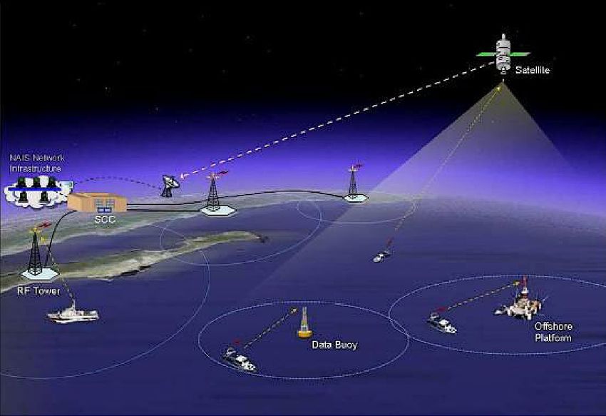
IPOL | Policy Department for Structural and Cohesion Policies

           3.2.2. Weaknesses of AIS                                              40
     3.3. Satellite remote sensing                                               41
           3.3.1. Strengths of SRS                                               41
           3.3.2. Weaknesses of SRS                                              41
     3.4. Applications combining different data sources                          42
           3.4.1. Strengths of applications combining different data sources.    42
           3.4.2. Weaknesses of applications combining different data sources.   42
     3.5. Conclusions                                                            43
4.   POLICY RECOMMENDATIONS                                                      44
     4.1. Positional data devices                                                45
     4.2. Emission time                                                          45
     4.3. Personal data protection                                               45
     4.4. Satellite remote sensing and positional data                           45
REFERENCES                                                                       46

                                                       4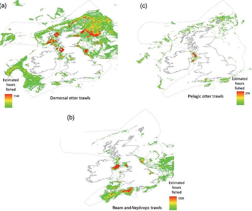
Workshop on electronic technologies for fisheries - Part I: Transmitted positional data systems

LIST OF ABBREVIATIONS
3D         Three Dimensional

ADS        Activity Detection Service

AIS        Automatic Identification System

BDS        BeiDou Navigation Satellite System

CFP        Common Fisheries Policy

CMS        Copernicus Maritime Surveillance

MSFD       Marine Strategy Framework Directive

ECDIS      Electronic Chart Display and Information System

EEZ        Exclusive Economic Zone

EFCA       European Fisheries Control Agency

EMSA       European Maritime Safety Agency

ESA        European Space Agency

ET         Electronic Technologies

EO         Earth Observation

EU         European Union

EVS        Enriched Vessel Service

FDS        Feature Detection Service

FMC        Fisheries Monitoring Center

GFW        GFW Global Fishing Watch

GLONASS    Global´naya Navigatsionnaya Sputnikovaya Sistema

GNSS       Global Navigation Satellite System

GPS        Global Positioning System

IMO        International Maritime Organisation

                                               5
IPOL | Policy Department for Structural and Cohesion Policies

 JDP                Joint Deployment Plans

 LRIT               Long Range Identification and Tracking

 MCS                Monitoring Control and Surveillance

 MMSI               Marine Mobile Service Identification

 MPA                Marine Protected Area

 MSFD               Marine Strategy Framework Directive

 MSP                Marine Spatial Planning

 NOAA               National Ocean and Atmospheric Agency

 OLE                Office of Law Enforcement

 S-AIS              Satellite Automatic Identification System

 SAR                Synthetic Aperture Radar

 SWOT               Strengths, Weaknesses, Opportunities and Threats

 TPDS               Transmitted Positional Data System

 US                 United States

 USA                United States of America

 VCS                Vessel Correlation Service

 VDS                Vessel Detection Service

 VHF                Very High Frequency

 VHR                Very High Resolution

 VHRRS              Very High Resolution Remote Sensing

 VMS                Vessel Monitoring System

 VTS                Vessel Traffic Service

                                                       6
Workshop on electronic technologies for fisheries - Part I: Transmitted positional data systems

LIST OF FIGURES
Figure 1: GNSS constellation systems                                                                         14
Figure 2: GNSS development timeline                                                                          14
Figure 3: Infographics explaining how GPS works                                                              16
Figure 4: Key elements of a Galileo Full Operational Capability satellite                                    17
Figure 5: AIS conceptual operation view                                                                      19
Figure 6: Ikonos data showing the very high resolution of current images from remote sensing                 20
Figure 7: Synthetic aperture principle                                                                       21
Figure 8: Classical ship wake pattern in SAR imagery                                                         22
Figure 9: Data flow of the EU VMS system                                                                     24
Figure 10: Estimated fishing activity of UK vessels by trawl gear types                                      27
Figure 11: Workflow of AIS data from emission to the Global Fishing Watch website                            29
Figure 12: Fishing effort of all fishing vessels present in European waters, January 2021                    30
Figure 13: Support of fisheries control through Copernicus Maritime Surveillance Service                     31
Figure 14: Example of vessel detection and detail of correlated vessel.                                      32
Figure 15: Example of Feature Detection System showing fish cages                                            33
Figure 16: Example of activity detection, in this case vessel search and rescue                              34
Figure 17: Example of vessel in a SARS image correlated to AIS data                                          35
Figure 18: Squid fishing off the coast of Argentina                                                          36

LIST OF TABLES
Table 1:    Estimation methods for spatial distribution of fishing activities through VMS data               28

                                                      7
IPOL | Policy Department for Structural and Cohesion Policies

                                                       8
Workshop on electronic technologies for fisheries - Part I: Transmitted positional data systems
EXECUTIVE SUMMARY
KEY FINDINGS
• The use of the current vessel monitoring system (VMS) for fisheries control and
scientific advice for fisheries management is being replaced on some occasions by the
automatic information system (AIS) due to data access problems and excessive time
laps between transmissions.
• Although AIS provides more information due to its higher frequency of emissions, it
does not have the same reception coverage and the same legal coverage. The
application of AIS is required for maritime safety reasons and not for fishing control.
• Newly developed electronic technologies (ETs) for merging positional data with
satellite images provide excellent data for both fisheries monitoring & control and
fisheries research. However, these data are not always available due to the low number
of daily images taken of a specific area or to the high price of such data fusion services.
Background
This study examines the existing ETs based on the collection of positional data as well as the
respective transmission systems, which are both applicable for purposes of fisheries control and
research. It also reviews space-based ETs providing very high resolution images, and assesses the
potential of data fusion techniques, through merging positional data and satellite image data.
Finally, strengths, weaknesses, opportunities and threats (SWOT) of the different ETs were scrutinised
with a view to achieve an improved monitoring of fishing activities in the fields of fisheries control
and research.
Transmitted positioning systems currently available
Currently, four global positional data systems exist, which are owned by the United States, the
European Union, Russia and China. They all use the same receivers as those installed in any common
cellular phone, and indicate the position of a vessel. The data can be easily ascertained with very high
accuracy.
A second type of spaceborne sensors used for fisheries control are the very high resolution sensors.
This technology is based on the inspection of the visual spectrum or on synthetic aperture radars
using microwave. Both systems can achieve high-resolution images of fishing vessels and are
currently used for fisheries control and research.
In the European Union, the compilation of satellite images for fisheries control is done by the
Copernicus Maritime Surveillance Service. It is also used by the European Fisheries Control Agency
(EFCA) in collaboration with the European Maritime Security Agency (EMSA).
Applications for transmitted positioning systems
Positional data are used primarily to study fishing effort and effects of fishing on marine habitats,
but also to support marine spatial planning activities. Regarding fisheries control, it is imperative to
9IPOL | Policy Department for Structural and Cohesion Policies
know the vessel’s position to understand if, where and what it is fishing and whether it is fishing in
the areas for which it is licensed.
Two of these applications currently exist and are used in fisheries control and research: the vessel
monitoring system (VMS), which was introduced in 1997 for fisheries position control, and the
automatic identification system (AIS), which was introduced in 2002 for maritime navigation security.
As a result, still today VMS is predominantly used for control purposes, while AIS is more frequently
used by fisheries researchers due to its higher emission frequency and accessibility.
This report also presents newly developed satellite imaging systems and their use in connection
with positional data. These systems are currently being used for fisheries control aiming to detect inter
alia catch transhipment or the position of boats that have turned off their VMS and/or AIS.
Analysis of the different options
VMS and AIS are both mature technologies whose accuracy has improved over time from the first
only prevailing global positional data system to the current multisystem scenario.
VMS has a more robust transmission technology using satellite communications, which make it very
difficult to loose data. Nevertheless, long time-laps between the emissions of data create caveats for
control and fisheries research.
AIS is more precise, as it has a higher transmission frequency due to its purpose of preventing
collisions at sea. However, it transmitting to land receivers proofs often to be difficult. In fisheries AIS
data are used for ex-post analysis due to being a secondary use of generated data.
Very high resolution satellite images provide very valuable information, which is even more useful
when combined with positional data. However, its main weakness are the longer time-laps between
images taken of the same ocean sector.
All the data sources present concerns and problems regarding current data privacy and personal
privacy rules, which need to be addressed.
Policy recommendations
Many of the newly developed satellite-driven electronic technologies based on positional data are
being used with great success. However, they cannot fully substitute traditional VMS yet, since the
spatio-temporal coverage of the fishing grounds is not sufficient and still depends on meteorological
conditions.
Based on the present analysis the following policy recommendations can be given:
• Extent the obligation to use tracking devices in commercial fishing vessels to the maximum
possible consensus.
• Increase the accuracy of VMS positional data so it can be of a similar magnitude as the actual
data provided by current GNSS systems (20 metres). The enforced precision indication of 500
metres was intended for the GPS capabilities of the late 20th century and not for current GNSS
systems like Galileo which enable accuracies of 20 metres at 99% confidence with free receivers
such as those used in mobile phones.
• Reduce the VMS emission time of both data types to ten minutes (instant transmission) and
one minute (stored data or delayed transmission), respectively. As our review of scientific
literature suggests, this could be achieved and would be ideal, both for fisheries research and
control. Nowadays cheaper means of transmission, as well as technologies capable of storing
10Workshop on electronic technologies for fisheries - Part I: Transmitted positional data systems
and transmitting huge volumes of data exist. In this way sufficient spatio-temporal resolution
to apply automated algorithms for detecting fishing activities could be achieved.
• Take the necessary actions to grant access to the generated data to control bodies and
scientific advisors for fisheries management while preserving the personal privacy of fishers.
• Follow-up on the work started recently, by combining VMS, AIS and VHR/SAR images as
complementary to the VMS data.
11IPOL | Policy Department for Structural and Cohesion Policies
12Workshop on electronic technologies for fisheries - Part I: Transmitted positional data systems
1. STATE OF PLAY OF TRANSMITTED POSITIONAL DATA SYSTEMS
KEY FINDINGS
• Two kinds of orbiting systems are mainly suitable for fisheries research, fisheries
management and enforcement of legal measures protecting marine ecosystems:
a) systems enabling calculation of a vessel’s positional data coupled to different
kinds of onshore/satellite receivers; and
b) the use of satellite remote sensing with very high resolution (VHR) images of
the visual spectrum or synthetic aperture radars (SARs) that detect vessels from
space.
• Positional systems are based on mature technologies, with a proven history of
successful data delivery, and have been used for decades in fisheries control.
• Satellite remote sensing and the use of visual or radar images is more recent; its
results in fisheries control are promising, complementing the use of positional
data.
1.1. Global Navigation Satellite Systems
A global navigation satellite system (GNSS) involves a constellation of satellites orbiting Earth, which
are continuously transmitting signals that enable users to determine their three-dimensional (3D)
position with global coverage (Sanz Subirana et al. 2013; Kumar et al. 2021a).
Examples of GNSS include Europe’s Galileo, the United States of America’s NAVSTAR Global Positioning
System (GPS), Russia’s Global'naya Navigatsionnaya Sputnikovaya Sistema (GLONASS) and China’s
BeiDou Navigation Satellite System (Figure 1) (GSA 2021; Kumar et al. 2021a).
A diagram of the historical development of global navigation from (Kumar et al. 2021b) is shown in
Figure 2.
The positioning principle is based on solving an elemental geometric problem, involving the distances
(ranges) of a user to a set of at least four GNSS satellites with known coordinates (Kumar et al. 2021b).
These ranges and satellite coordinates are determined by a receiver using the signals and navigation
data transmitted by the constellation of satellites; the resulting coordinates can be computed to an
accuracy ranging from several metres to centimetre level when using more advanced techniques (Sanz
Subirana et al. 2013).
13IPOL | Policy Department for Structural and Cohesion Policies
Figure 1: GNSS constellation systems
Source: (Kumar et al. 2021a)
Figure 2: GNSS development timeline
Source: Kumar et al. 2021b
14Workshop on electronic technologies for fisheries - Part I: Transmitted positional data systems
1.2. NAVSTAR Global Positioning System
GPS is an American space-based navigation system which enables calculation of a three-dimensional
position to about a metre of accuracy (e.g. latitude, longitude and altitude). It further provides
nanosecond-precise time anywhere on Earth where there is a direct line of sight to at least three GPS
satellites. It operates independently of any telephonic or internet reception, providing critical
positioning capabilities to military, civil, and commercial users around the world.
As with any other GNSS, GPS consists of three different parts (Sanz Subirana et al. 2013), see Figure 3:
• Space Segment: a constellation of at least 24 satellites owned by the US government
distributed in six orbital planes in a medium Earth orbit at about 20,200 kilometres,
circling the Earth every 12 hours;
• Control Segment: land stations monitoring and maintaining the satellites;
• User Segment: the receivers that process the navigation signals from the satellites and
calculate position and time.
In the early 1970s, the United States Department of Defence sought to implement a robust, secure
satellite navigation system. Adopting previous ideas from United States Navy scientists, the
Department of Defence decided to use satellites for their proposed navigation system. The first GPS
satellite was launched in 1978 and the GPS system became fully effective in 1993 (Mai 2017b).
Today, GPS is a multiuse, space-based navigation system owned by the US government and operated
by the United States Air Force to meet national defence, homeland security, civil, commercial and
scientific needs (Mai 2017a).
15IPOL | Policy Department for Structural and Cohesion Policies
Figure 3: Infographics explaining how GPS works
Source: https://www.gps.gov
16Workshop on electronic technologies for fisheries - Part I: Transmitted positional data systems
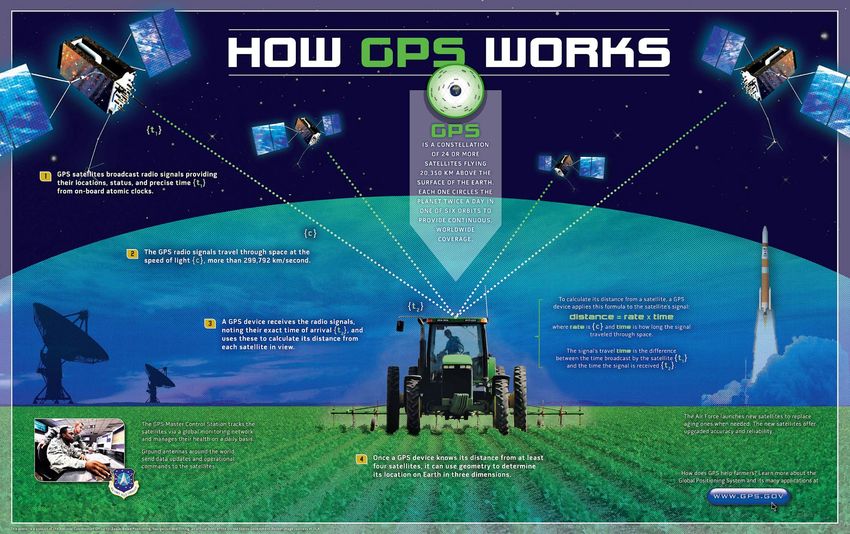
1.2.1. GALILEO
The European Union is the main sponsor and the owner of Galileo, according to current regulations.
Whereas the program was financed jointly with the ESA in its early stages, full deployment has been
financed with European Union budget funds. As the executive arm of the European Union, the
European Commission is the program manager (Javier Pérez Bartolomé et al. 2015).
Galileo is a complete GNSS. Since becoming operational in 2016, it has aimed to provide an
independent high-precision positioning system so that the European Union and other nations do not
have to depend on systems owned and controlled by other countries (Javier Pérez Bartolomé et al.
2015), which can degrade or shut off their systems at any time.
Figure 4: Key elements of a Galileo Full Operational Capability satellite
Source: https://www.esa.int/Applications/Navigation/Galileo/Satellite_anatomy
Full operational capability of Galileo was predicted for late 2019. However, this goal was only reached
at the end of 2020 (Nurmi. J et al. 2015). The next generation of satellites (Figure 4) is set to become
17IPOL | Policy Department for Structural and Cohesion Policies
operational after 2025, replacing older equipment that may begin developing technical problems due
to ageing (Lohan 2015).
The Galileo system’s accuracy is greater than its US counterpart GPS. Galileo is accurate to less than one
metre when using broadcast ephemeris (GPS: three metres) and 1.6 centimetres when using real-time
corrections for satellite orbits and clocks (Lohan 2015).
1.2.2. Other GNSS systems
Russia’s GLONASS or Global Navigation Satellite System is another space-based satellite navigation
system (Kumar et al. 2021a). It provides an alternative to GPS and GALILEO and was the second
navigational system in operation, with global coverage becoming fully operational in November 2011
(Nurmi J. et al. 2015).
The BeiDou Navigation Satellite System (BDS) is the Chinese GNSS. The Compass or Beidou-2 GNSS
is being developed by China and has a regional and a global component (Nurmi. J et al. 2015). BDS
currently provides global coverage for timing and navigation, offering an alternative to the other
systems (China 2016).
1.3. Marine monitoring solutions based on GNSS data
1.3.1. Vessel monitoring system
Advances in satellite tracking technologies have moved very quickly over the past 25 years, though
tracking of fishing vessels did not attract much attention until the mid-1980s, when satellite technology
became commercially viable for tracking purposes (FAO 1998). About 1991, several fisheries agencies
began investigations and trials that ended with the implementation of different vessel monitoring
systems (VMSs).
VMS is a general term for systems that are used on board commercial fishing vessels to allow control
agencies to track and monitor fishing activities. VMS is nowadays a key part of the monitoring, control
and surveillance (MCS) systems of almost all the countries involved in world fisheries (FAO 1998).
The exact function of VMS varies among countries, but all have several common characteristics.
• it provides position information to the control agency in near to real time;
• it can also provide speed and heading or they can be computed by the control agencies;
• the vessel operator can indicate the start and end of fishing operations and transmit other
codes (i.e. entering a port or fishing zone) (FAO 1998).
The term VMS is only used for systems controlling the activity of fishing vessels and should not be
confused with vessel traffic services (VTS) such as the automatic identification system (AIS), which
are marine traffic monitoring devices focused on safety in ports and busy waterways.
1.3.2. Automatic identification system
The International Maritime Organisation's International Convention for the Safety of Life at Sea requires
that the automatic identification system (AIS) be fitted on board international voyaging ships with
300 or more gross tonnage and on all passenger ships regardless of size (IMO 1980). For various reasons,
ships can legally turn off their AIS transceivers, mainly when navigating in risky zones with a persistent
pirate presence.
18Workshop on electronic technologies for fisheries - Part I: Transmitted positional data systems
AIS is one of the first open-standard data-broadcast communication systems on board ships. It
operates in the VHF maritime band and has been adopted within the global maritime environment as
a vessel traffic service (Chaturvedi 2019). AIS data exchange supplements human use of marine radar,
which is still the primary method of preventing vessel collisions.
An approved AIS must transmit different message types, including ship data, required by the
International Maritime Organisation (IMO) performance standards, as follows (IMO 1980):
• Static and voyage related data (name and call sign, MMSI (maritime mobile service
identification), size, type, draught and route plan, etc.);
• Dynamic information (ship position, time of data transmission, course over ground, speed over
ground, heading, rate of turn, pitching and yawing, etc.).
AIS transceivers can be tracked by other AIS transceivers on board a different vessel or marine
platform or by AIS base stations located along coastlines or through a growing number of satellites
that are fitted with special AIS receivers that can decode a large number of signatures (Perez et al.
2009), see Figure 5.
Studies and experiments are in progress for the reception of AIS signals from space by small low-Earth
orbit constellations (Chaturvedi 2019) this will improve the AIS reception when a vessel is far from
coastline AIS base stations; when satellites are used to detect AIS signatures, the term Satellite-AIS (S-
AIS) is used.
Figure 5: AIS conceptual operation view
Source: Perez et al. 2009
19IPOL | Policy Department for Structural and Cohesion Policies
1.4. Marine monitoring solutions based on satellite remote sensing (SRS)
Among all the spaceborne sensors deployed so far, two are especially appropriate for vessel
detection and tracking. Their main characteristics and capabilities are explained below.
1.4.1. Very high resolution remote sensing
A very high resolution (VHR) remote sensing satellite is an orbiting satellite mounting optical sensors
that provide multispectral and panchromatic images at resolutions from 50 metres (1 pixel = 60 metres)
to less than 1 metre.
Ikonos was the first commercial high-resolution satellite sensor (1999) to break the one metre mark
(see Figure 6). Since then, many other very high resolution (VHR) satellites have been launched
(Eugenio & Marcello 2018). Another important milestone was the launch in 2009 of WorldView-2, the
first commercial non-military VHR satellite to provide eight spectral channels in the visible to near-
infrared range.
Images from these commercial satellites can be used to detect and track vessels, mainly in inland
waters, since there are still few VHR-capable satellites watching the open sea. Most of the
companies that own VHR satellites have divisions or subsidiary companies which provide paid access
to raw images or products derived from analysis of VHR images.
Figure 6: Ikonos data showing the very high resolution of current images from remote sensing
Source: SpaceImaging, Europe
20Workshop on electronic technologies for fisheries - Part I: Transmitted positional data systems
1.4.2. Synthetic aperture radar
Radar has long been used for military and non-military purposes in a wide variety of applications
such as imaging, guidance, remote sensing and global positioning (Chan & Koo 2008).
Side looking airborne radar, a predecessor of synthetic aperture radar (SAR), was developed in the
1950s. In 1952 a Doppler beam-sharpening system was developed by Wiley of the Goodyear
Corporation, opening the way to development of the first airborne SAR (Chan & Koo 2008).
In SAR, the forward motion of the actual antenna is used to ‘synthesise’ a very long antenna enabling
the creation of two dimensional images (pictures) or three-dimensional estimations of the shape
of real objects. Since SAR usually uses operating frequencies in the microwave range, it can
penetrate clouds, haze, rain, fog and other precipitation with almost no attenuation. As an active sensor
which illuminates the inspected object, SAR operates day or night without differences.
As in conventional photo cameras, the larger the aperture, the higher the image’s resolution. In the
case of spaceborne SAR, the antenna is synthetic and created by the real antenna’s movement along
the satellite orbit (see Figure 7). This principle added to the aperture given by the distance to the object
enables the production of high-resolution images from spaceborne SARs that can be used to detect
vessels from space (see Figure 8).
Figure 7: Synthetic aperture principle
Source: (Chan & Koo 2008)
21IPOL | Policy Department for Structural and Cohesion Policies
Figure 8: Classical ship wake pattern in SAR imagery
Source: https://sentinels.copernicus.eu/
The EU Copernicus programme has had the Sentinel-1 satellites in service since 2014. These satellites
use an SAR with wide area coverage and improved revisit times and can potentially detect smaller ships
than older satellite missions.
The mission's ability to observe in all weather during the day or at night makes it ideal for precise cueing
and location of ship activities at sea, allowing for more efficient and cost-effective use than other
security assets such as patrol aircraft and ships (ESA 2012a).
Sentinel-1 data relevant to ship detection is transmitted by the satellite in real-time for reception by
local collaborative ground stations supporting European and national services which will be described
in section 2.3.
22Workshop on electronic technologies for fisheries - Part I: Transmitted positional data systems
2. CURRENT APPLICATIONS USING TRANSMITTED POSITIONAL
DATA SYSTEMS
KEY FINDINGS
• The use of each of the data sources identified has been analysed from literature
and sources publicly available on the internet.
• VMS has mainly been used by EFCA and the Member States’ fishing authorities.
But it has been increasingly used in the academic world since the change in some
user/usage rules enabling easier access to such data.
• Among all the transmitted positional data systems (TPDS) identified, AIS is the
most widely used due to the short time between transmissions, public availability
of data and increased detection on the high seas with the deployment of more
satellite AIS receivers. All these characteristics make AIS, a system not designed for
fisheries control, the main spatial data source used by fishery researchers and non-
governmental organisations to develop spatial research of fisheries (effort
distribution, marine spatial planning, etc.).
• Finally, the use of satellite VHR and SAR systems has mainly been for enforcement
and control and as such only accessible to the national or European Fisheries
Control bodies through the European Maritime Safety Agency (EMSA) or to
private clients with the financial ability to pay very specialised companies that offer
solutions very similar to those of the EMSA.
To depict the applications currently used to enforce fisheries legislation or fisheries research, a
representative group of case studies will be presented for each of the transmitted positional data
systems shown in Chapter 1 and for both satellite imaging sources.
2.1. Applications using a vessel monitoring system
2.1.1. The EU vessel monitoring system for fisheries control.
The VMS is a satellite-based monitoring system which provides data at regular intervals to fisheries
authorities concerning the position of European fishing vessels (EFCA 2021).
VMS is nowadays a standard tool for fisheries monitoring and control worldwide. The EU had led the
way, becoming the first part of the world to introduce compulsory VMS tracking for all larger boats in
its fleet (FAO 1998).
EU legislation requires that all coastal EU countries should set up systems that are compatible with each
other, so that countries can share data and the Commission can monitor compliance with rules. EU
funding is available for Member States to acquire state-of-the-art equipment and train their people to
use it (EFCA 2021).
The European Fisheries Control Agency (EFCA) was created by the European Union to promote the
highest common standards for control, inspection and surveillance under the Common Fisheries Policy
23IPOL | Policy Department for Structural and Cohesion Policies
(CFP) and to ensure Europe-wide that European obligations are complied with by everyone and that
everyone in the fishing sector is treated equally, wherever they might be operating.
The EFCA’s work comprises joint deployment plans (JDPs) established for fisheries deemed a priority
by the European Commission and the concerned Member States. EFCA control activities are planned
for each year based on the results of regional risk assessments.
When a Member State or the EFCA performs a sea-based inspection, the VMS data are used by patrol
vessels and aircraft to find the inspected fishing vessel at sea. In the event of land-based inspections
(see Figure 9), VMS advises beforehand that a fishing vessel is approaching its harbour to land catches
so that land-based inspectors can be ready to inspect them. Finally, VMS is used by the different
national fishing authorities as a tool to monitor that a vessel is not fishing in prohibited or closed zones
such as marine protected areas (MPA) or territorial waters of a different EU Member State.
Figure 9: Data flow of the EU VMS system
Source: ECA 2017
24Workshop on electronic technologies for fisheries - Part I: Transmitted positional data systems
Even though legal provisions regarding the use of satellite-based VMS for fisheries control have been
updated at several occasions by the European legislator since 1997 1, the main technical provisions for
the characteristics for satellite-tracking devices remained merely unchanged:
Art. 19, Commission Implementing Regulation (EU) 404/2011 2):
“The satellite-tracking device installed on board Union fishing vessels shall ensure the automatic
transmission to the FMC [Fisheries Monitoring Centre] of the flag Member State, at regular intervals, of data
relating to:
(a) the fishing vessel identification;
(b) the most recent geographical position of the fishing vessel, with a position error which shall be less
than 500 metres, with a confidence interval of 99 %; [...]."
As a consequence, Union’s legal requirements for the use of VMS were neither adapted to the level of
data precision of newly developed GNSS systems with a standard position error of less than 50 metres,
nor to the improved and more cost-efficient satellite communication systems allowing a much higher
position transmission frequency (Lambert et al. 2012).
2.1.2. The US vessel monitoring system for fisheries controls
The VMS in the US is used to support law enforcement initiatives and to prevent violations of laws and
regulations. VMS also helps enforcement personnel focus their patrol time on areas with the highest
potential for significant violations (NOAA 2021b).
The VMS programme currently monitors more than 4 000 vessels, the largest national fleet forced to
have an active VMS during its fishing operations. The system operates 24 hours a day, 7 days a week
with near-perfect accuracy, which is why the programme is of interest to other users, including the US
Coast Guard and fishery researchers. VMS data are, by law, subject to strict confidentiality requirements
(NOAA 2021b), making it very difficult to use this data for academic work (Westfall et al. 2020).
The US VMS hardware architecture is very similar to the one used in the EU. But it differs mainly in the
time between position reports, typically once an hour, and the ability to automatically decrease time
intervals when the vessel is approaching environmentally sensitive areas such as MPAs. Alerts can be
sent to the VMS technicians and other personnel when a particular vessel location might require
additional inquiry or contact with the vessel operator (NOAA 2021b).
Other uses for the vessel monitoring system in the US are:
• Managing sensitive and protected areas such as marine sanctuaries;
• Monitoring the activity and arrival of vessels in port to plan for inspections;
• Supporting the catch share programs;
• Tracking, monitoring, and predicting fishing effort, activity and location;
• Managing observer programs;
• Verifying/validating data from other sources;
1
See: Commission Regulation (EC) No 1489/97 of 29 July 1997 laying down detailed rules for the application of Council Regulation (EEC)
No 2847/93 as regards satellite-based vessel monitoring systems
2 See : COMMISSION IMPLEMENTING REGULATION (EU) No 404/2011 of 8 April 2011 laying down detailed rules for the implementation of
Council Regulation (EC) No 1224/2009 establishing a Community control system for ensuring compliance with the rules of the Common
Fisheries Policy
25IPOL | Policy Department for Structural and Cohesion Policies
• Identifying fishing vessels.
Similar to the EFCA, in the United States the National Oceanic and Atmospheric Administration (NOAA)
created the Office of Law Enforcement (OLE). The OLE is dedicated to enforcing laws that conserve and
protect US marine resources and their natural habitat by ensuring compliance with domestic law and
supporting international treaty requirements designed to preserve global fish resources (NOAA 2021c).
The OLE publishes on its website all relevant inspections and law infringements on a weekly basis
(NOAA 2021a). This makes it difficult to compare the performance of the EFCA and the OLE in pursuing
fishery infringements.
2.1.3. Use of VMS data in fisheries science in the EU
In Europe, vessel monitoring systems were introduced for fishery control and enforcement purposes
but are increasingly used to support the assessment of fishing activity and marine spatial planning
(Murawski et al. 2005).
The growing time-series of VMS data are beginning to allow fishery scientists to take into account fine-
scale spatial and temporal aspects of commercial fishery data, enabling the mapping of fishing effort
(see Figure 10) (Murawski et al. 2005; Witt & Godley 2007; Bastardie et al. 2010; Lee et al. 2010; Gerritsen
& Lordan 2011; Lambert et al. 2012; Enever et al. 2017; Birchenough et al. 2021).
Based on all these studies, almost all the main fishing gear operating in Europe have a published
method to identify fishing times (Table 1), enabling an estimate of fishing effort to be produced (Lee et
al. 2010). This information and the methods are nevertheless not routinely used when producing
scientific advice for fisheries management, because it is difficult for scientists to gain access to VMS on
a regular basis due to confidentiality rules (Hinz et al. 2013).
Another major area of scientific study using VMS data are marine spatial planning (MSP), which tries to
spatially arrange different uses of the seas (Murawski et al. 2005; Campbell et al. 2014; Tolvanen et al.
2019).
The third main area of study is to quantify the effects of fishing in the marine benthos by means of the
number of fishing operations over the different habitats studied (Lambert et al. 2012; Gerritsen et al.
2013; Rijnsdorp et al. 2013; Eigaard et al. 2017).
Given the original purpose of introducing such systems, the use of VMS data for research and impact
assessment has some limitations. These include incomplete coverage of vessel activities, overly long
durations between position records and a lack of information about whether a vessel is fishing or not
when the position is reported (Lee et al. 2010).
Due to such problems, different authors have proposed various approaches to interpolate fishing
tracks from insufficient VMS data (Hintzen et al. 2010; Russo et al. 2011), methods to solve the mismatch
between VMS temporal resolution and fishing activity time scales (Katara & Silva 2017) or even to
compare VMS and AIS data to test the best interpolation for fishing tracks (Shepperson et al. 2018)
26Workshop on electronic technologies for fisheries - Part I: Transmitted positional data systems
Figure 10: Estimated fishing activity of UK vessels by trawl gear types
Source: Lee et al., 2010
In order to make it easier for more scientists to use the European VMS, two open software packages
have been developed and are available to the scientific community for VMS data analysis (Russo et al.
2011; Hintzen et al. 2012), including many of the previously cited extrapolation methods.
27Workshop on electronic technologies for fisheries - Part I: Transmitted positional data systems
Table 1: Estimation methods for spatial distribution of fishing activities through VMS data
Source: Lee et al., 2010
28Workshop on electronic technologies for fisheries - Part I: Transmitted positional data systems
2.1.4. Use of VMS data in fisheries science in the United States of America
VMS data from US fishing vessels have only rarely been used in research (Murawski et al. 2005; Palmer
& Wigley 2009), despite the fact that the US has more vessels with VMS (> 4,000) than any other nation.
Since the installation of VMS devices is compulsory in the USA, there are tens of millions of VMS records
available for some fisheries. This data represents a major source of information for fisheries
management but is nevertheless largely under-utilised as it is linked to strict confidentiality rules.
2.2. Applications using an automatic identification system
As stated in the Chapter 1, the need to negotiate access to VMS data with national control authorities
has so far confined research applications to specific fisheries and local areas (Natale et al. 2015).
In addition to VMS, another system providing detailed vessel positioning data are the automatic
identification system. The AIS was introduced in 2002 by the International Maritime Organisation (IMO)
to improve maritime safety and avoid ship collisions (Bastardie et al. 2010).
The AIS has some advantages over VMS, as the time between transmissions is shorter, from two
seconds to three minutes, and it is relatively easy to access AIS data from free repositories or from
private companies, subject to a fee (Dupont et al. 2020).
Figure 11: Workflow of AIS data from emission to the Global Fishing Watch website
Source: https://globalfishingwatch.org/
29IPOL | Policy Department for Structural and Cohesion Policies
But the AIS also shows disadvantages, such as difficulties in receiving the respective signals if the vessel
is more than 50 miles from a land antenna or if this signal is not received by one of the AIS satellites
(Harati-Mokhtari et al. 2007).
Different authors have tried to compare the estimates of fisheries effort calculated from AIS data and
from VMS data (Natale et al. 2015; Stasolla et al. 2016; Shepperson et al. 2018) or to develop algorithms
to detect transhipments (Miller et al. 2018) or even formulate methods to detect sailing anomalies for
law enforcement (Pallotta et al. 2013).
The areas of research in fisheries using AIS are mainly the same as when using VMS, but with a larger
number of studies due to the easier access to AIS data (Miller et al. 2018; Dupont et al. 2020)
The most extensive scientific work using AIS data to research fisheries is being carried out by “Global
Fishing Watch” (GFW), an independent, international non-profit organisation originally set up through
a collaboration between three partners: “Oceana”, an international organisation dedicated to
protecting and restoring the ocean; “SkyTruth”, experts in using satellite technology to protect the
environment; and “Google”, who provides the tools for processing big data. The main product of the
GFW is a web page (https://globalfishingwatch.org/map/), providing all kinds of fishing activities based
on AIS data received from satellites, and merged with data from some governments (mainly VMS data)
as well as SARS data. The workflow of GFW is showed in Figure 11 and the main product of GFW are
fishing effort maps like the one shown in Figure 12.
Figure 12: Fishing effort of all fishing vessels present in European waters, January 2021
Source: https://globalfishingwatch.org/map/
30Workshop on electronic technologies for fisheries - Part I: Transmitted positional data systems
2.3. Applications using satellite remote sensing
2.3.1. European Maritime Safety Agency - Copernicus Maritime Surveillance
The European Maritime Safety Agency (EMSA) is a regulatory agency that originated in the late 1990s
along with a number of other major European maritime safety initiatives. The EMSA was established by
Regulation (EC) no. 1406/2002 as a major source of support for the Commission and the Member States
in the field of maritime safety and prevention of pollution from ships. Subsequent amendments have
refined and enlarged its mandate.
Figure 13: Support of fisheries control through Copernicus Maritime Surveillance Service
Source: © EMSA 2018
The European Commission initiated studies on integration of remote sensing in fisheries control in the
first years of the 21st century, starting with SAR images (Kourti et al. 2014) and adding VHR multispectral
images when available (Kourti et al. 2005).
These studies were the starting point for the “Copernicus Maritime Surveillance” (CMS) Service (see
Figure 13), which provides earth observation products (satellite images and value-adding products) to
support better understanding and improved monitoring of activities at sea (EMSA 2020).
CMS has a wide range of operational functions such as maritime safety and security, fisheries control,
customs, law enforcement, marine environment pollution monitoring, and others. Implemented by the
EMSA, it is a security service of the EU’s Copernicus Programme for maritime surveillance purposes
(EMSA 2020).
31IPOL | Policy Department for Structural and Cohesion Policies
The benefits from Earth observation data do not lie solely in the volume of data available, but rather in
its intelligent use in a targeted manner. The value-added products offered by the CMS service aid users
by extracting particularly valuable information from the basic image products, allowing authorities to
undertake higher level analysis of objects, features or activities at sea more quickly and efficiently
(EMSA 2020).
The value-added products can be provided either as a layer on top of the original satellite image
product or as a separate layer of information, for example a vector layer. This enables users to select
which individual product or combination of products is relevant to them.
For example, a user requesting high resolution optical data to support the search for an individual
vessel may want a vessel detection layer to quickly identify the location of all vessels in the area, but
also the original image product layer to see the details of the vessels to narrow down the search.
The value-added products currently being offered by EMSA to users include the following:
• “Vessel Detection Service” (VDS),
• “Feature Detection Service” (FDS), and
• “Activity Detection Service” (ADS).
a. EMSA Vessel Detection Service (VDS)
This service entails the delivery of value-added products, mainly using high and very high resolution
images, focusing on vessel detection. The “Vessel Detection Service” (VDS) refers to the extraction of
vessel positions based on echoes or detectable objects in the satellite image that may be vessels.
Figure 14: Example of vessel detection and detail of correlated vessel.
Source: © EMSA 2019
32Workshop on electronic technologies for fisheries - Part I: Transmitted positional data systems
“Enriched Vessel Service” (EVS) merges vessel detection and classification. It entails further analysis of
satellite images and contains elements which were not included in the VDS.
b. EMSA Feature Detection Service
This service entails the delivery of value-added products, mainly using high and very high-resolution
images, focusing on feature detection. The “Feature Detection Service” (FDS) aims to detect features of
interest at sea, along the shoreline and in harbour areas which are not covered by other EMSA EO
products (oil spill detection, vessel detection or activity detection).
Figure 15: Example of Feature Detection System showing fish cages
Source: © EMSA 2019
FDS includes the following attributes:
• Feature description – high-level description of the detected feature;
• Position – latitude/longitude coordinates;
• Time stamp – date/time of acquisition.
33IPOL | Policy Department for Structural and Cohesion Policies
c. EMSA Activity Detection Service (ADS)
This service entails the delivery of value-added products, mainly using very high resolution images,
focusing on activity detection. The purpose of the “Activity Detection Service” (ADS) is to report
information about activities of interest detected in the satellite images, over a defined area at a given
time. For example, when the user requests an ADS for at-sea-encounter only at-sea-encounters shall
be included in the delivered product and no other activities such as oil pollution.
Figure 16: Example of activity detection, in this case vessel search and rescue
Source: ©EMSA 2019
2.4. Applications combining different data sources
2.4.1. EMSA Copernicus Maritime Surveillance – Vessel Correlation Service
Copernicus Earth observation images can be integrated with other data both from EMSA’s maritime
information applications and from external data sources. This additional data may include information
such as vessel location, identification and tracking data (for example, “Automatic Identification System”
(AIS), “Long Range Identification and Tracking” (LRIT), and “Vessel Monitoring System” (VMS)), intelligence
data provided by users and external meteorological data (EMSA 2020). Combining data makes the
overall information provided to Member State users more operationally valuable. Vessel position and
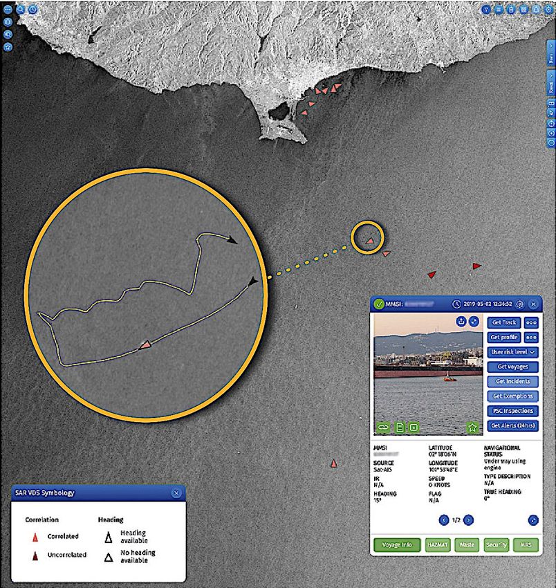
track information, for example, overlaid on satellite images with a vessel detection layer Figure 17,
provide a very powerful tool for checking on vessel activity at sea – including verifying those vessels
that are reporting and locating vessels that are not reporting their whereabouts (EMSA 2020). EMSA
provides these fusion products to CMS service users according to their needs and to their data access
rights.
34Workshop on electronic technologies for fisheries - Part I: Transmitted positional data systems
Figure 17: Example of vessel in a SARS image correlated to AIS data
Source: © EMSA 2019
2.5. Private companies offering applications using satellite remote
sensing (SRS)
A growing number of private companies, most of them subsidiaries of companies owning private
satellites, are offering applications very similar to the services granted by EMSA to European and
national control bodies. For instance, German European Space Imaging offers a Total Maritime
Situational Awareness product that merges VHR, SARS and AIS data, whose capabilities range from
vessel detection and oil spill monitoring to assistance for marine fish farms so they can avoid algae
bloom contamination.
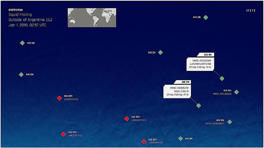
Another example of a company offering to the private sector products similar to the ones in the EMSA
portfolio is the Finnish ICEYE, which detect vessels through SAR images and correlates them with AIS
data to find vessels that have intentionally switched off their AIS transponders and gone ‘dark’. An
example is shown in Figure 18, where ‘dark fishing’ vessels are identified.
An AIS match was found with several Chinese fishing vessels. Additionally, there are several
unidentified dark vessels which are presumed to be engaging in fishing.
35IPOL | Policy Department for Structural and Cohesion Policies
Figure 18: Squid fishing off the coast of Argentina
Source: ICEYE Analytics
36Workshop on electronic technologies for fisheries - Part I: Transmitted positional data systems
3. BENEFITS AND RISKS OF TRANSMITTED POSITIONAL DATA
SYSTEMS
KEY FINDINGS
• To identify the benefits and risks of each of the electronic technologies analysed in
Chapter 2, a strengths, weaknesses, opportunities and threats (SWOT) analysis of
each of them was carried out. From the different SWOT analyses, it was concluded that
none of the current technologies are ideal for the current objectives of control and
scientific studies in fisheries and that a technical update of the current VMS could be
the best solution.
• The current VMS specifications have become obsolete, considering the current
technical capacities. The main problem is that legislation makes its use compulsory for
fishing vessels, with the technical requirements (precision and frequency) formulated
in 2002 and not updated since then.
• The AIS, which has aged better and adapted to new technologies, could satisfy
scientific needs, but it was not designed for fisheries control and its use conflicts with
laws governing privacy protection and personal data use.
• High-resolution satellite images offer uses that are not covered by the two previous
technologies when it comes to providing evidence of unwanted behaviour, but the
number of satellites is insufficient in order to continuously monitor fisheries and there
are doubts as to whether they comply with privacy requirements.
• The use of combined, transmitted positional data and satellite images provides results
that cannot otherwise be offered, thought also combines the legal weaknesses of both
data sources.
In this chapter the benefits and risks of each of the technologies studied in Chapter 2 will be analysed
for fisheries control and fisheries science. The analyses consisted of a SWOT analysis of technologies
identified in Chapter 2 and the identification of technologies more suitable for fisheries control and
scientific use of the compiled data.
The SWOT analysis was performed for strengths and weaknesses by studying the scientific literature
that will be cited in the bullet points after each SWOT. As for opportunities and threats, a group of AZTI
researchers, experts in the areas of data collection and stock evaluation in different fisheries (Atlantic
Ocean, tropical tuna fisheries, small local fisheries), was invited to a meeting to discuss and identify
these parameters; the results for that meeting were used for the OT part of each SWOT analysis.
37IPOL | Policy Department for Structural and Cohesion Policies
3.1. Vessel monitoring system
STRENGTHS WEAKNESSES
• Reliable and well tested. • Legal rules not adapted to
• Rules of use well known by current technological
fishers. development.
• Infrastructure already in • Long time lag between
place in all Member States. transmissions.
• Real time reception and use • Low legal spatial accuracy.
of data. • Confidentiality impedes use
for uses not controlled.
• The GPS can be jammed.
OPPORTUNITIES SWOT THREATS
• Upgradeable to current • If updated, fishers would be
technological developments. reluctant to abide by stricter
• Can be adapted to new and control measures.
cheaper communication • Confidentiality issues from
technologies.
• Potential to be routinely used data protection laws could
in fisheries science. impair its use for fisheries
• Machine learning and fishing science if this is not
events identification methods
developed with AIS could be addressed in the new
easily adapted if faster fisheries control framework.
emission frequencies are
implemented.
3.1.1. Strengths of VMS
VMS technology can be defined as a reliable and well-tested technology (FAO 1998; Vermard et al.
2010; Gerritsen & Lordan 2011) which in the case of EU countries has been used since 1997 and operates
in all Member States (EFCA 2021).
The facilities of the different National Fisheries Monitoring Centres and the European Fisheries Control
Agency can receive and use the CMS data in real time to ask for sea-based or land-based inspections
(EFCA 2019).
Finally, fishers are well-informed about the VMS rules (Borit & Olsen 2012) and fishers positively value
that the monitoring be carried out by public institutions and no other agents (Garza-Gil et al. 2015).
3.1.2. Weaknesses of VMS
One of the main weakness of VMS is that the minimum technical requirements requested in current
legislation are outdated and far from the current capabilities of GNSS with respect to spatial accuracy
(Mendo et al. 2019; Kumar et al. 2021a) and time between transmissions (Katara & Silva 2017;
Shepperson et al. 2018; Mendo et al. 2019).
Regarding scientific use, another major weakness is the confidentiality issues which currently hamper
scientific access to this high-resolution effort data, thus endangering the provision of management
advice based on the best available knowledge (Hinz et al. 2013).
The received global navigation satellite system (GNSS) signal has very low power due to travelling a
very long distance and the nature of the signal’s propagation medium. GNSS signals are thus easily
susceptible to signal interference (Shehaj et al. 2017). Signal interference can cause severe degradation
or interruption in GNSS position, navigation, and timing (PNT) services which could be very critical.
38You can also read