WY Conditions & Outlooks: April 15, 2021 Precipitation, Temperatures, Drought, Floods, & Everything In-between
←
→
Page content transcription
If your browser does not render page correctly, please read the page content below
WY Conditions & Outlooks:
Precipitation, Temperatures, Drought, Floods, & Everything In-between

                             April 15, 2021

                 The University of Wyoming is an equal opportunity/affirmative action institution.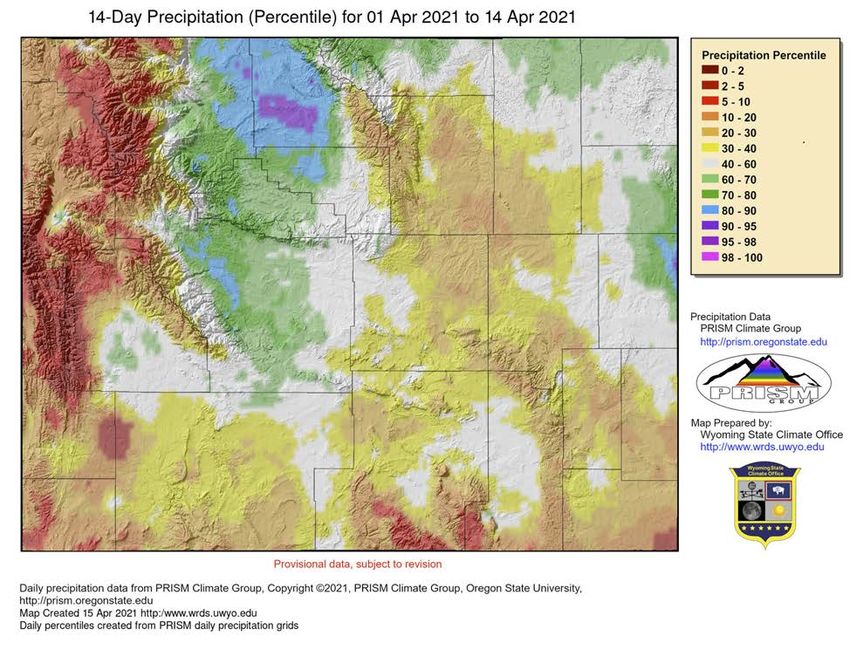
Presentation Outline
● Current Conditions
● Outlooks
● How to Get Involved
Current Conditions
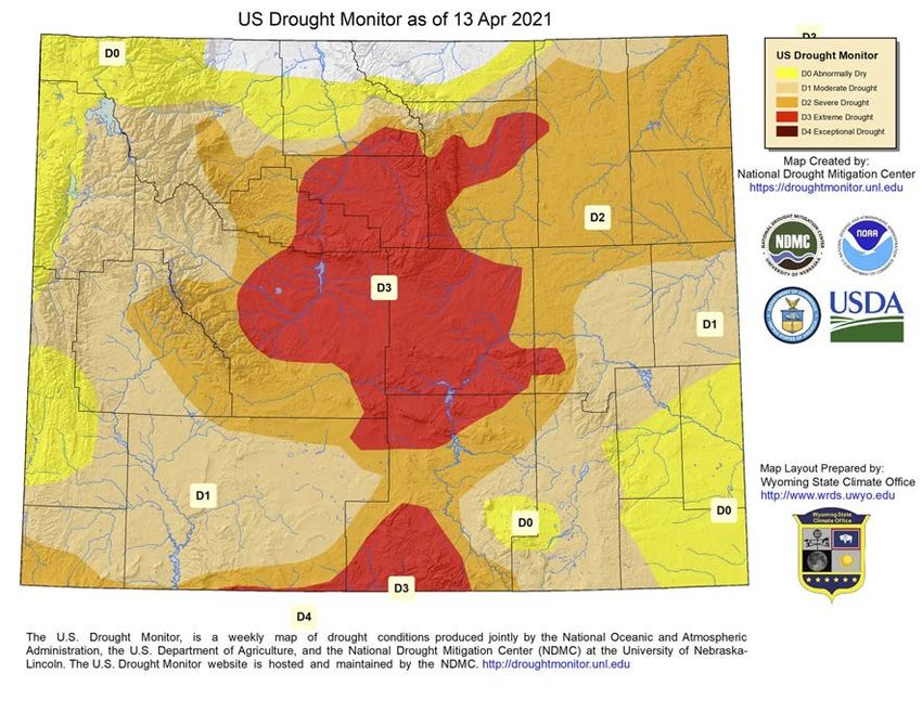
Drought Level              Percentile
                                 US Drought Monitor for April 13, 2021
                                       (Released Thursday, April 15, 2021)         None                       >30
                                                 Valid 8 a.m. EDT
                                                                                   D0 (Abnormally Dry)        21 to 30
                                                                                   D1 (Moderate Drought)      11 to 20
                                                                                   D2 (Severe Drought)        6 to 10
                                                                                   D3 (Extreme Drought)       3 to 5
                                                                                   D4 (Exceptional Drought)   0 to 2

                                                                             Continued wetness in north-central
                                                                             Wyoming has prompted improvements
                                                                             this week while a growing deficit has led
                                                                             to degradation in the west.

https://droughtmonitor.unl.edu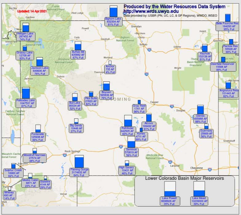
14-Day Precipitation Percentile (01 Apr 2021 to 14 Apr 2021)

Above Median:
 ● Bighorn Basin
 ● Fremont County
 ● Far East-central
 ● Far Northeast

Below Median (Areas of Concern):
 ● West
 ● South
 ● Eastern Central
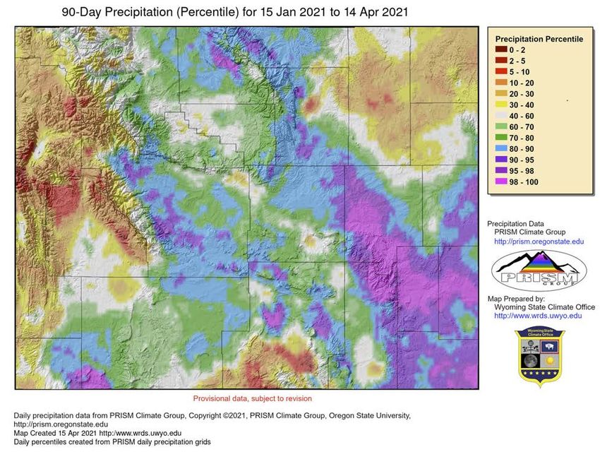
90-Day Precipitation Percentile (15 Jan 2021 to 14 Apr 2021)

Above Median:
 ● Sweetwater, eastern Uinta County
 ● Central
 ● North-central
 ● East-central
 ● Southeast

Below Median (Areas of Concern):
 ● Far South-central
 ● Far West
 ● Northeast
30-Day                     60-Day

Standardized Precipitation Index (SPI)
  ● Wet SPIs north-central Wyoming
    improved US Drought Monitor
  ● Negative SPIs in Western Wyoming   90-Day
    caused further degradation of
    conditions.
https://drought.climate.umt.edu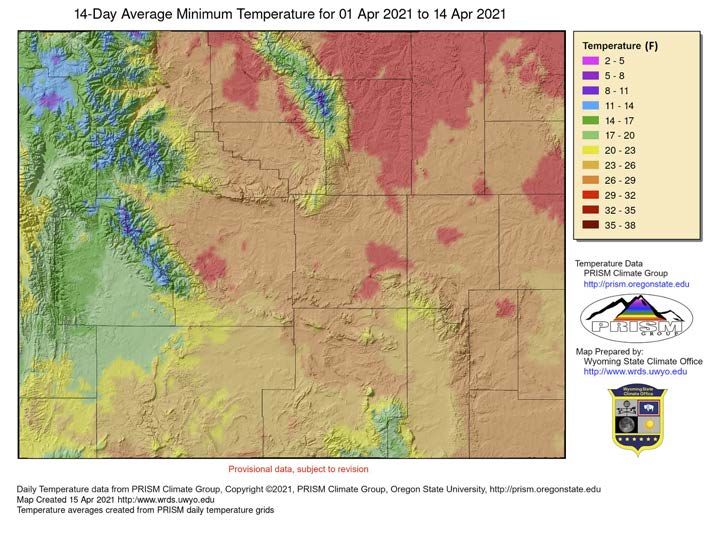
14-Day Average Minimum
  Temperature (01 Apr to 14 Apr)
● Nighttime lows still below freezing

                                     14-Day Departure from Normal
                                    Average Minimum Temperature
                                    ● Northeast & Central above average
                                    ● West/Southwest below average
                                    ● Southeast mixed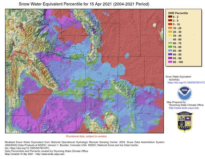
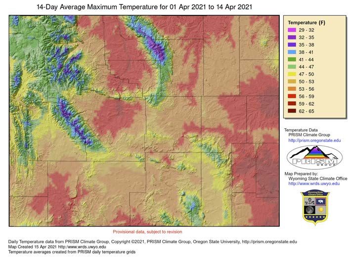
14-Day Average Maximum
Temperature (01 Apr to 14 Apr)
 ● Daytime highs above freezing

                                  14- Day Departure from Normal
                                                Average Maximum
                                                       Temperature
                                     ● Mostly above average
                                     ● Southwest 3-6F above average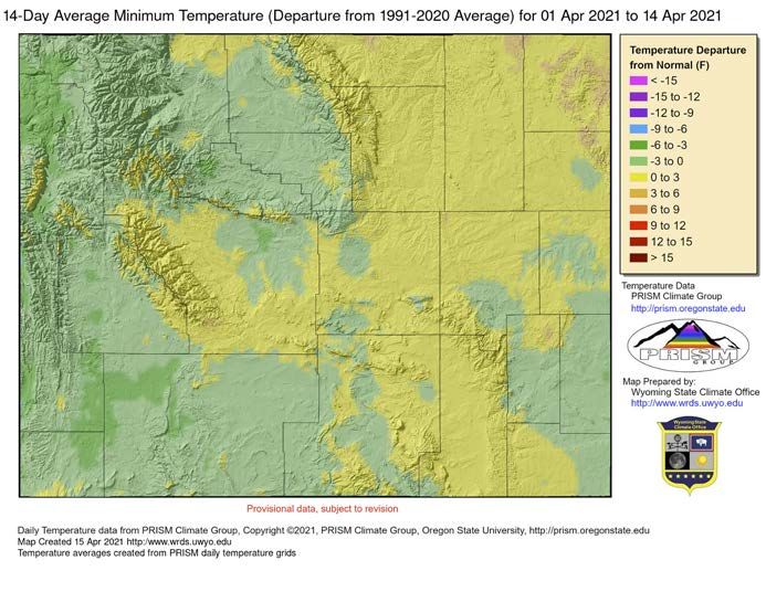
Basin Snow Water Equivalent (SWE)
                                          Percent of Median
   2 Weeks Ago (01 Apr 2021)                                       Today (15 Apr 2021)

                                                          All basins had declined until 14 Apr when far NW and far
http://www.wrds.uwyo.edu/wrds/nrcs/snowmap/snowmap.html   SE improved. Bighorn and Tongue Basins unchanged
Modeled Snow Water Equivalent (SWE)
2-Week Comparison
01 Apr 2021 15 Apr 2021
Storms of the last two days have improved lower
http://www.wrds.uwyo.edu/snow/Current_SWE_Ptile.html
elevation snow levels in central and southern Wyoming.Soil Moisture Percentile
31 Mar 2021 14 Apr 2021
30-40 0-2
10 2-5 30-40 2-5
-2
0 5-10
20-30 5-10 5-10 10-20
5-1
0 10-20
10-20
2-5 10-20 2-5
2-5
0-2 0-2
20-30 10-20
Soil Moisture has worsened in most places other than the
Bighorn Basin and East-central Wyoming
http://www.wrds.uwyo.edu/Soil/Current_SoilMoisture_Ptile.htmlSoil Moisture at Thunder Basin Mesonet Station Infiltration into soil from melting March 6-Apr snows Different response times at varying depths
Streamflow 4/14/21

Current (7-day average) streamflow compared
 to historical streamflow for this time of year
                                                  ● Higher elevation sites still in
                                                    ice (white dots)
                                                  ● Flows generally are near
                                                    normal.
                                                  ● Green, Bear, North Platte
                                                    (near Nebraska) and Bighorn
                                                    Rivers are below normal

                                                          https://waterwatch.usgs.gov
Streamflow 4/14/21
A closer look at select dry
areas
https://waterwatch.usgs.gov
https://waterdata.usgs.gov/Streamflow 4/14/21
Current (28-day average) streamflow compared
to historical streamflow for this time of year ● Longer term averages agree
well with the 7-day average.
● It’s early and the effects of
persistent/current precipitation
and snow-melt trends on runoff
will become more evident in the
coming weeks.
https://waterwatch.usgs.govReservoir Storage (4/14/21) ● Very modest ~1 -2% gains in
storage from last month.
● Storage volumes continue to
lag behind this time last
year.
2020
http://www.wrds.uwyo.edu/surface_water/teacups.htmlWind River Reservation: Conditions & Impacts
● The Wind River Reservation has received moisture the last few weeks, much better
place than early March, but not out of the woods yet
● Much of the moisture is going into the ground and not showing up as increased
stream and river flows; this most recent storm may change that
● Streamflows are also down due to colder than normal temps
● Still major concerns along Little Wind drainage regarding the drought
● Better towards the north and south ends of the Wind River Range
○ (Togwotee, Owl Creeks, South Pass, Lander area)
● This years impact will be greater unless significant spring moisture due to last years
drought conditions; cannot make up for the lack of hay produced last year
● Market forces along with weather still impacting local producers (price of diesel,
price of feed, cattle prices, etc)
● Thank goodness for the recent moisture and lower temps
● Critical period for the next 2 months as drought worsens or conditions improveForecasts & Outlooks
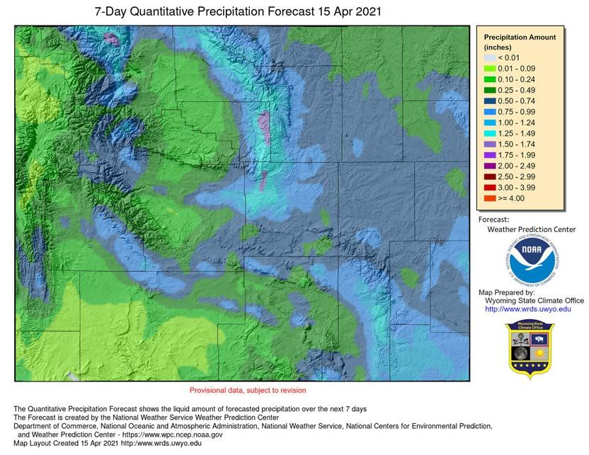
7-Day Quantitative Precipitation Forecast
                                        April 15 - 22

                                           0.25”-0.75”      ● Quantitative Precipitation
                                                              Forecast = Liquid
0.25”-0.50

                            1.0
                                                              Precipitation Forecast
                               0-1
                                  .75
                                     ”
                                         0.5”-0.75”
                                                            ● Widespread Snow Today
                                                              through early Saturday
             0.
               5”

                                                            ● Cold Front passage Late
                 -1
                   .0
                     0”

                                                              Sunday into Monday with
                                                              more snow likely
6-10 Day Precipitation
April 20 - 24
● Probability = Chance
● Below normal chances of
precipitation favored
6 - 10 Day Temperatures
● Below normal temperatures
favored for the state.
http://bit.ly/3kq3LxA8-14 Day Precipitation
April 22 - 28
● Probability = Chance
● Slightly Below normal precipitation
favored for the state.
8 - 14 Day Temperatures
● Equal Chances of near normal
temperatures favored for the
state.
http://bit.ly/3kw1WPF● Note: WY’s weather is not as strongly connected to ENSO due to our distance from the ocean ● Coming out of La Nina to neutral = more precipitation possible? ● Slight indication of another La Nina next summer & fall = dry long-term? https://bit.ly/30cxMaS
Long Term Drought & Increased Wildfire Risk
https://bit.ly/3uYbneR                                          https://bit.ly/3uZyPsd

  ● Persistent drought or               ● Greater chance of significant
    development likely for the state.     wildfires occurring in the SW.
Wyoming Snotel Snapshot Update
Snotel Sites - (Snow Telemetry) -
North Laramie Mtns.
are monitoring stations measuring
snowpack, precipitation,
temperature & other climate
conditions.
● Pockets of near to above normal in
North Laramie Range, Big Horn
Mountains, & Sierra Madre Range
Wind River Range
● However, Wind River Range,
Wyoming Range, and high terrain in
NW Wyoming remain below to well
below normal
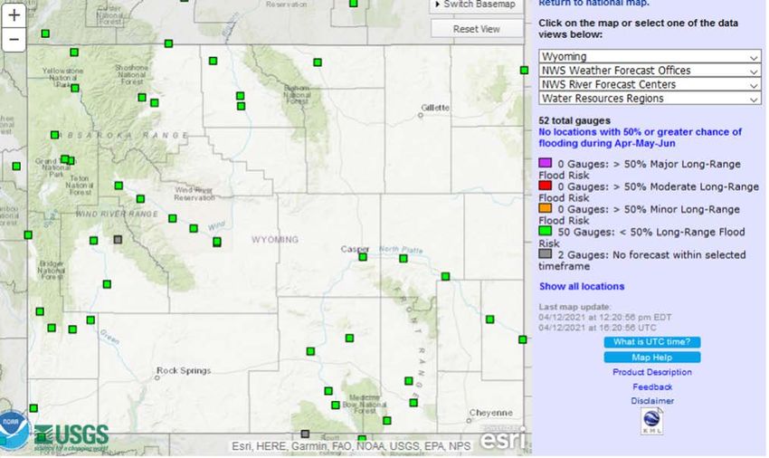
https://bit.ly/2ON67uTWyoming Flood Potential Update
Valid April-May-June No riverine flooding is
expected through
June.
This graphic depicts the NWS
river forecast locations, colored
by the highest flood category
expected during the next 90-
days. All Wyoming stations are
projected to stay below Flood
Stage.
Please note that river ice action
is NOT accounted for in our
river forecast model.
water.weather.gov
NWS Long Range River Flood Outlooks NOAA U.S. Spring Outlook & Flood RiskHow to get involved ...
Drought Level              Percentile
                                 US Drought Monitor for April 13, 2021
                                       (Released Thursday, April 15, 2021)         None                       >30
                                                 Valid 8 a.m. EDT
                                                                                   D0 (Abnormally Dry)        21 to 30
                                                                                   D1 (Moderate Drought)      11 to 20
                                                                                   D2 (Severe Drought)        6 to 10
                                                                                   D3 (Extreme Drought)       3 to 5
                                                                                   D4 (Exceptional Drought)   0 to 2

                                                                             Continued wetness in north-central
                                                                             Wyoming has prompted improvements
                                                                             this week while a growing deficit has led
                                                                             to degradation in the west.

https://droughtmonitor.unl.edu
April 15, 2021:
24-hour precip as of ~ 7 am https://www.cocorahs.org
WY Act
iv e Statio
n Locat
ionsCondition Monitoring Observer Reports http://bit.ly/3c4WRLR
Condition Monitoring
 Observer Reports
   http://bit.ly/3c4WRLR
● Regardless of conditions, consider
submitting a report monthly
● Comparison photos
○ A picture is worth a thousand
words!
● Web browsersTony Bergantino Brandon Reynolds
WRDS & State Climate Office Tribal Water Engineers Office
antonius@uwyo.edu brandon.reynolds@writc.org CoCoRaHS
https://www.cocorahs.org
Aviva Braun Aaron Fiaschetti
National Weather Service
Cheyenne USGS
aviva.braun@noaa.gov afiaschetti@usgs.gov Condition Monitoring
Observer Reports
Kevin Low Windy Kelley (CMOR)
MO Basin River Forecast Center USDA NPCH & UW-Extension
http://bit.ly/3c4WRLR
kevin.low@noaa.gov wkelley1@uwyo.edu
Thank you! Questions?You can also read