YEAR 1 NON-COMPULSORY REDUCTION REPORT EL27151 SKYFALL
←
→
Page content transcription
If your browser does not render page correctly, please read the page content below
YEAR 1 NON-COMPULSORY REDUCTION REPORT

                   EL27151

                   SKYFALL

   FOR PERIOD ENDING 8TH November 2014

          DALY RIVER PROJECT NT

          PINE CREEK SD5208           1:250,000
          FERGUSSON RIVER SD5212      1:250,000
          Daly River 5070             1:100,000
          Wingate Mountains 5069      1:100,000
          Jinduckin 5169              1:100,000

   Titleholder: Spectrum Rare Earths Limited
       (Previously TUC Resources Limited)

                                          Report No. 2014- 053
                            Prepared for Spectrum Rare Earths
                                                By A Crabtree
                                               November 2014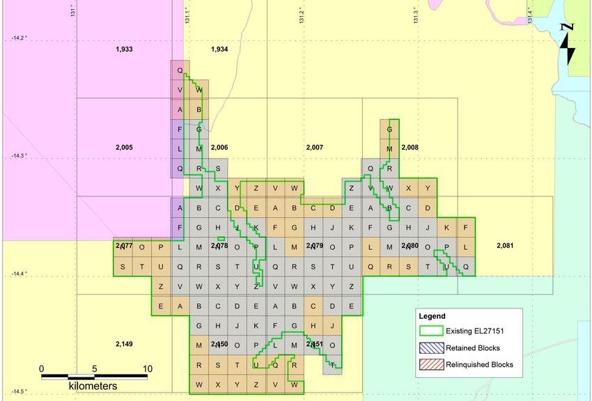
Reduction Report EL27151
Report 2014-053

                                                  CONTENTS

CONTENTS .............................................................................................................. 2
LIST OF FIGURES .................................................................................................... 2
1.     SUMMARY ......................................................................................................... 3
2.     LOCATION AND ACCESS ................................................................................. 3
3.     TENEMENT STATUS AND OWNERSHIP ......................................................... 5
4.     GEOLOGY ......................................................................................................... 7
5.     PREVIOUS EXPLORATION .............................................................................. 9
     5.1     Historical Exploration on EL27151 .............................................................. 9
6.     SPECTRUM EXPLORATION ........................................................................... 13
     5.2     Exploration during Year 1 (2014) ............................................................... 13
7.     REFERENCES................................................................................................. 14
8.     APPENDICES .................................................................................................. 15
     Appendix A – Historical Exploration ..................................................................... 15

                                           LIST OF FIGURES
Figure 1: Project Area and Prospect Location with Underlying Cadastre– EL27151
(Skyfall) (coordinates in GDA94 z52)......................................................................... 4
Figure 2: EL27151 Reduction. Retained Blocks – Blue, Surrender blocks – Red. ..... 6
Figure 3: Fergusson River Geological Map (1:250000) over Spectrum Tenements
(GDA94z52). ............................................................................................................. 8
Figure 4: Historic Geophysics Surveys over Spectrum’s Skyfall Prospect. ................ 9
Figure 5: Flight Line Spacing for Geophysics Surveys over Spectrum’s Skyfall
Prospect. ................................................................................................................. 10
Figure 6: Historic Surface Geochemistry Thematically Mapped by Lead across the
District. .................................................................................................................... 11
Figure 7: Historic Surface Geochemistry Thematically Mapped by Uranium across
the District. .............................................................................................................. 11
Figure 8: Historic Drill Holes Location over The Skyfall Prospect............................. 12

                                                                                                                               2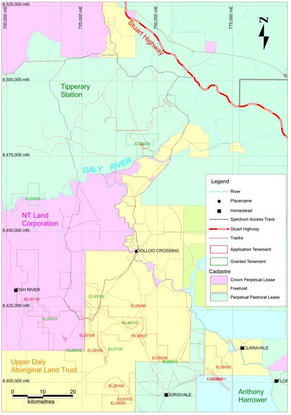
Reduction Report EL27151
Report 2014-053

       1. SUMMARY
EL27151 is 170km south of Darwin (by road). Spectrum Rare Earths Limited (Spectrum) is
exploring for primarily rare earth mineralisation. Work during Year 1 of tenure consisted of a
review of both NTGS data, compilation of significant results from Industry reports and
geophysical data review.
No exploration was completed on the relinquished ground in Year 1.

       2. LOCATION AND ACCESS
EL27151 (Skyfall Prospect) is located approximately 93km South-West of Pine Creek,
Northern Territory on the Fergusson River (SD 52-12) 1:250,000 and Jinduckin 1:100,000
topographic map sheets.
EL25171 is 170km due south of Darwin, and approximately 220km south of Darwin by road
(Figure 1). Access from Darwin is via the Stuart Highway onto the Douglas Daly Road to
Oolloo Crossing, then a track to Fish River transects the southern and western portion of the
Licence. Access is via station tracks crossing the Daly River at Oolloo Crossing on Oolloo
Station or Beeboom Crossing on Tipperary Station to the northern sector or via Dorisvale to
the southern sector. The area is inaccessible during the wet season until about May or June.
Easy Access from Darwin is via the Stuart Highway during the dry season, Access by
helicopter via Pine Creek during the wet season. Most of the ground is open and with low
relief and numerous sinkholes.

                                                                                            3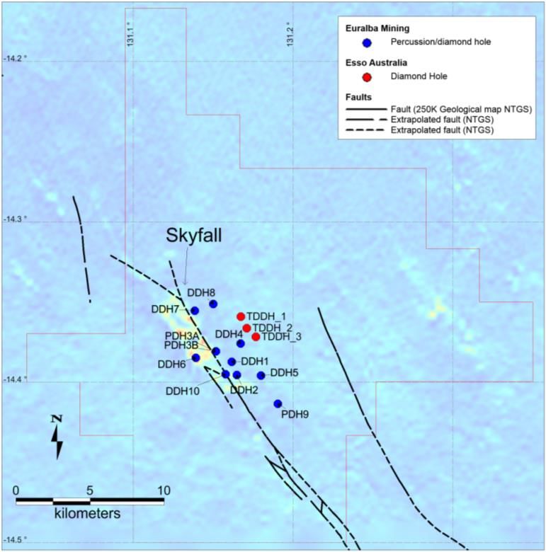
Reduction Report EL27151
Report 2014-053

    Figure 1: Project Area and Prospect Location with Underlying Cadastre– EL27151 (Skyfall)
                                   (coordinates in GDA94 z52).

                                                                                               4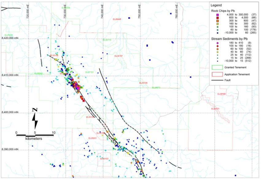
Reduction Report EL27151
Report 2014-053

       3. TENEMENT STATUS AND OWNERSHIP
                           th                                 th
EL27151 was granted on 8 November 2013 and expires on 7 November 2019. It comprises 93
graticular blocks (254.25km²) (Figure 1). There are no other mining leases or mineral claims shown
within the Licence boundaries.
Underlying cadastre is crown lease in perpetuity held by:
Upper Daly Aboriginal Land Trust, NT portion 4059.

Tenement Reductions:

                      Table 1: Details of Tenement Reductions for EL25171.

                                                            Blocks           Blocks
                                                            retained         relinquished
First Year Non-Compulsory Reduction                         93               55

This report details exploration carried out by Spectrum on Year 1 relinquished ground for the
duration that it was held.

The expenditure covenant set for the first year was $27,000.

                                                                                                5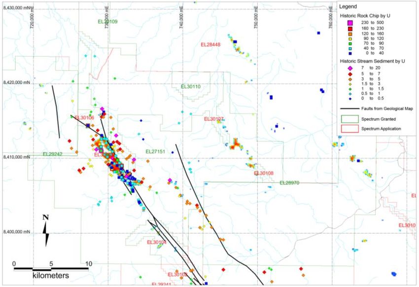
Reduction Report EL27151
Report 2014-053

                           Figure 2: EL27151 Reduction. Retained Blocks – Blue, Surrender blocks – Red.

                                                                                                          6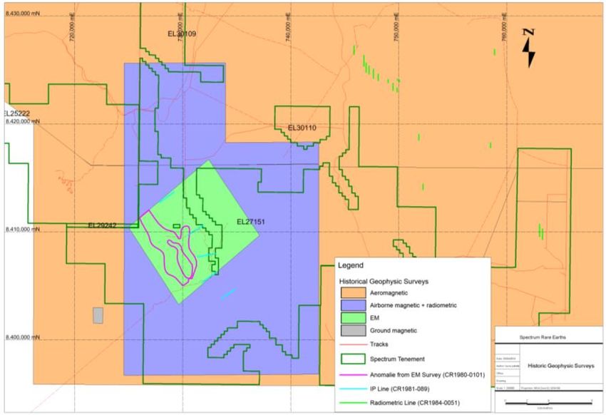
Reduction Report EL27151
Report 2014-053

       4. GEOLOGY

EL27151 is situated near the western margin of the Pine Creek Orogen. The northern part
of the tenement is within the SD5208 Pine Creek sheet, while most of the tenement is on the
SD5212 Fergusson River sheet. Descriptions of the regional geology can be found in
several texts, including Ahmad et al., 1993; Ahmad, 1998; Pontifex & Mendum, 1972;
Dundas et. al., 1987; and Edgoose et. al., 1989.
Middle Proterozoic sediments of the Tolmer Group are mapped as overlying the western
portion of EL27151. The Tolmer Group is a sequence of arenite, siltstone and dolomite up
to 1600m thick unconformably overlying Early Proterozoic Finniss River Group sediments.
The Stray Creek Sandstone and Hinde Dolomite are the most common stratigraphic units of
the Tolmer Group within EL27151. Fault splays from the Giants Reef Fault to the west offset
and thrust blocks of Stray Creek Sandstone adjacent to Hinde Dolomite within EL27151.
The Cambrian Antrim Plateau Volcanics is mapped as overlying portions of the Tolmer
Group. Further east, limestones and quartzarenites of the Cambro-Ordovician Daly River
Group (comprising Tindall Limestone and Jinduckin Formation) form the Daly Basin. Figure
2 shows the mapped geology.

The region has also been incorporated in the NTGS mineral resource projects. These
include regional phosphate prospectivity which has been analysing selected rock chips from
water bores in the district (Khan et al., 2007). No significant phosphate anomalies were
noted in the Daly Basin.

                                                                                         7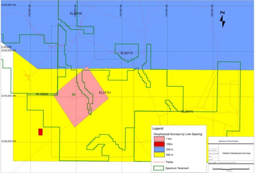
Reduction Report EL27151
Report 2014-053

                           Figure 3: Fergusson River Geological Map (1:250000) over Spectrum Tenements (GDA94z52).

                                                                                                                     8
Reduction Report EL27151
Report 2014-053
5. PREVIOUS EXPLORATION
5.1 Historical Exploration on EL27151
Spectrum completed a data compilation of previous companies’ exploration efforts in the
area through the Mineral Exploration Reports provided by NTGS. Useful results and reports
are summarised in Tables in Appendix A. Tables include company name, report number,
exploration license number, commodity and important information extracted from the reports.
Most of the exploration work undertaken over EL27151 was from 1967 to 1995. Different
companies have been successively looking for diamonds, base metals and gold. Diamond
was the most targeted commodity over the exploration licences; the most advanced
exploration was for base metals. No rare earth exploration has ever been undertaken in this
area.
A number of geophysical surveys have been conducted over EL27151.
Figure 4 displays the different surveys conducted in the area. Four types of surveys cover
the Skyfall Prospect (aeromagnetic, radiometric, electromagnetic and IP surveys), however,
line spacing is generally wide (Figure 5); 1km for electromagnetic survey and 400m for the
radiometric survey. Despite the broad line spacing radiometric data pointed out radiometric
anomalies over EL27151.
Skyfall
Figure 4: Historic Geophysics Surveys over Spectrum’s Skyfall Prospect.
9Reduction Report EL27151
Report 2014-053
Skyfall
Figure 5: Flight Line Spacing for Geophysics Surveys over Spectrum’s Skyfall Prospect.
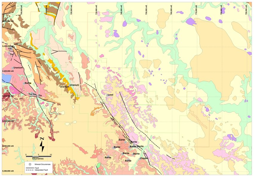
Greenfield exploration including stream sediment, soil and rock chip sampling was
conducted by previous companies. Best results highlighted base metals and uranium
anomalies along the Dorisvale Fault mostly concentrated on the now named Skyfall
radiometric anomaly. Results obtained from the previous companies are summarised in
tables in Appendix A and displayed in Figure 6 and Figure 7. A general base metal anomaly
was noted. The mineralisation has been interpreted to be a carbonate-hosted base metal
type. Notable values included up to 320ppm uranium, 800ppm copper, 19.3% lead and
1.65% zinc.
10Reduction Report EL27151
Report 2014-053
Skyfall
Figure 6: Historic Surface Geochemistry Thematically Mapped by Lead across the District.
Skyfall
Largo
Knightfall
Figure 7: Historic Surface Geochemistry Thematically Mapped by Uranium across the District.
11Reduction Report EL27151
Report 2014-053
Subsequently drilling was completed over the Skyfall area first by Euralba Mining and then
by Esso Australia, summarised in Figure 8 and Appendix A. Euralba Mining drilled 10
percussion/diamond holes and found values up to 47 ppm uranium, 20,000 ppm zinc and
48,000 ppm lead. Following this, Esso Australia drilled 3 holes identifying sulphides
associated with sediment breccia interpreted as a carbonate-hosted epigenetic type deposit.
The best values were up to 1,000ppm lead, 220ppm copper and 7,500ppm zinc. Importantly
these holes were not tested for rare earths.
Spectrum has digitally compiled the geological logs from these holes and plotted them on
cross sections. However, recorded geological descriptions have been of limited use in
developing Spectrum’s exploration model. Attempts have been made to correlate the
described drilling to recently mapped geology but have been unsuccessful. Spectrum has
made every attempt to locate the core from these holes but to no avail. No core
photography has been located despite a significant search.
Figure 8: Historic Drill Holes Location over The Skyfall Prospect.
12Reduction Report EL27151
Report 2014-053
6. SPECTRUM EXPLORATION
5.2 Exploration during Year 1 (2014)
No exploration was completed on the relinquished ground.
13Reduction Report EL27151
Report 2014-053
7. REFERENCES
Ahmad, M., 1998. Geology and mineral deposits of the Pine Creek Inlier and McArthur
Ahmad, M., Wygralak, A.S., Ferenczi, P.A., and Bajwah, Z.U. 1993. Explanatory Notes
and Mineral Deposit Data Sheets. 1:250,000 Metallogenic Map Series, Department of
Mines and Energy, Northern Territory Geological Survey
Bajwah, Z.U., 1994. A Contribution of Geology, Petrology and Geochemistry to The Cullen
Batholith and Related Hydrothermal Activity Responsible for Mineralisation, Pine Creek
Geosyncline, Northern Territory. Report 8, Northern Territory Geological Survey.
Bao, Z., Zhao, Z., (2007). Geochemistry of mineralization with exchangeable REY in the
weathering crusts of granitic rocks in South China. Key Laboratory for Metallogenic
Dynamics, Guangzhou Institute of Geochemistry, Chinese Academy of Sciences,
Guangzhou, 510640, People’s Republic of China.
Crick, I., 1980. Geology of the Batchelor-Hayes Creek Region. BMR 1:100,000 Geological
Special.
Dundas, D.L., Edgoose, C.J., Fahey, G.M., and Fahey, J.E., 1987. Daly River 5070
Explanatory Notes 1:100,000 Geological Map Series; Northern Territory Geological Survey.
Edgoose, C.J., Fahey, G.M., and Fahey, J.E., 1989. Wingate Mountains 5069
Explanatory Notes 1:100,000 Geological Map Series; Northern Territory Geological Survey.
Khan, M., Ferenczi, PA., Ahmad, M., and Kruse, P.D., 2007. Phosphate testing of
waterbores and diamond drillcore in the Georgina, Wiso and Daly basins, Northern
Territory. Northern Territory Department of Primary Industry, Fisheries and Mines
Geological Survey Record 2007-003.
Martin, R. F., 2006, A-type granites of crustal origin ultimately result from open-system
fenitization-type reactions in an extensional environment: Lithos, v. 91, no. 1-4, p. 125-136.
Needham et al. 1980
Pontifex I.R. and Sweet, I.P., 1972: 1:250 000 geological map series explanatory notes.
Fergusson River, Northern Territory. Sheet SD/52-12 International Index. Bureau of Mineral
Resources, Geology and Geophysics.
Lottermoser, B, G. (1990). Rare-earth element mineralisation within the Mt. Weld carbonatite
laterite, Western Australia. Department of Geology, University of Newcastle, Newcastle, N.
S. W. 2308 (Australia).
Pontifex, I.R., and Mendum, J.R., 1972. Fergusson River 1:250,000 Geological Series –
Explanatory Notes. BMR 250,000 Geological Series.
Rade, J., 1956. Shearing along anticlines as an important structural feature in uranium
mineralisation in the northern part of the Northern Territory of Australia. Journal of
Economic Geology.
Young, B., and Prince, K. E., 2013. Mineralogy of the Stromberg Deposit STDH03 Sample.
TECHNICAL MEMORANDUM: AM/TM/2013_06_18. Ansto Minerals.
14Reduction Report EL27151
Report 2014-053
8. APPENDICES
Appendix A – Historical Exploration
Files include:
(/BB3BB$SSHQGL[$
9 CONFIDENTIALITY STATEMENT
This document and its content are the copyright of Spectrum Rare Earths Ltd. The document has
been written for submission to the Northern Territory Department of Mines and Energy as part of the
tenement reporting requirements as per the Mineral Titles Act (NT). Any information included in the
report that originates from historical reports or other sources is listed in the “References” section at
the end of the document. All relevant authorisations and consents have been obtained. Spectrum
Rare Earths Ltd authorises the department to copy and distribute the report and associated data.
15You can also read