CLICK TO KNOW MORE 2-4 April 2019 Taets Art and Event Park, Amsterdam - Host - Geospatial World Forum
←
→
Page content transcription
If your browser does not render page correctly, please read the page content below
Co-Host                                         Host

                      2-4 April 2019
          Taets Art and Event Park, Amsterdam

               CLICK TO KNOW MORE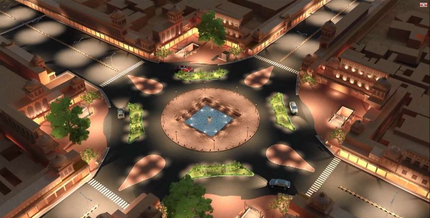
Jaipur Metro Rail Project:
Construction of metro in heritage city of
 Jaipur and opportunities for usage of
         Geospatial technology

                     by
      AKHILESH KUMAR SAXENA
       Executive Director (Civil), JMRC

        Hyderabad, January 2018

                                            1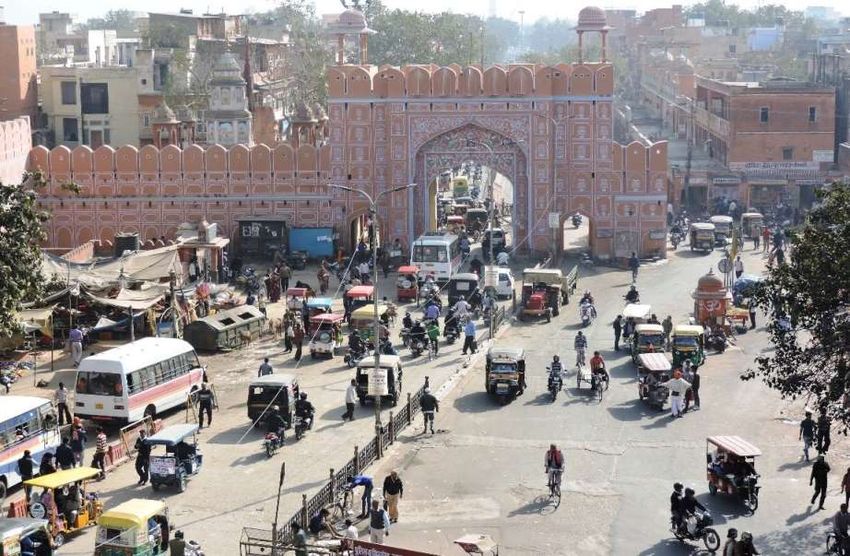
Jaipur
Jaipur (the Pink City) is strategically
located, is a heritage city and a
major tourist destination.
With a population of 3.1 million in
2011 and an annual population
growth of 4.6%, it is one of the
fastest growing 3 million plus cities
in India (Population 8.1 m by 2031).
(Rajasthan) Jaipur has about 2 million private
vehicles and the lowest share
(19%) of public transport among 3
million plus cities of the country.
CMP (2010) prepared by M/s
Wilbur Smith (now CDM Smith)
recommended Metro on 2 major
corridors having a PHPDT >10,000.
Map of India
2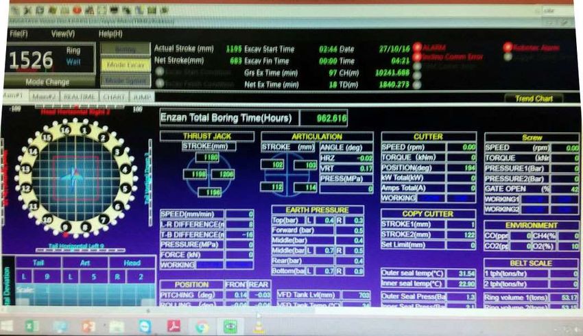
Project at a Glance
North

                 Phase-I
              (E-W Corridor)
              PHPDT 11264
        CBD

                 Phase-II
              (N-S Corridor)
              PHPDT 12901

                                                     3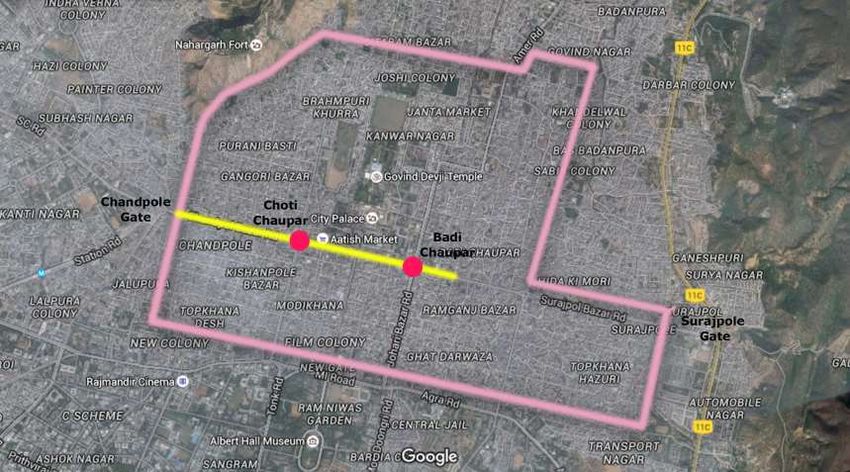
Project at a Glance
                                                                                      Projected
       Phase              Length (in kms)              No. of Stations            Completion Cost
                                                                              (Rs in Cr.)     (Million
                       Total   Elevated     UG Total      Elevated       UG                    US$)
     Phase-I
Mansarovar to Badi     12.0       9.1       2.9   11          8          3     3,149           511
    Chaupar
    Phase-IA
  Mansarovar to
                        9.6       9.1       0.5   9           8          1     2,023           328
   Chandpole
Already Commissioned
     Phase-IB
   Chandpole to
                       2.4         -        2.4   2           -          2     1,126           183
   Badi Chaupar
 Under Construction
      Phase-II
     Sitapura to
                       23.8       13.8      10    20         13          7    10,394          1686
     Ambabari
   Planning Stage

Underground corridor has been planned in and around the walled city and aiport

                                                                                                     4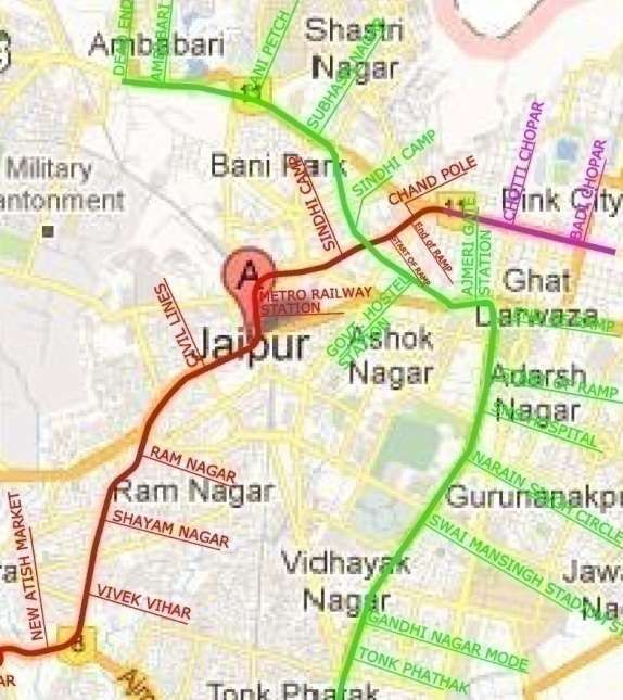
Phase IA
(Mansarovar to Chandpole: 9.6 kms/ 9 stns)
Work commenced on 24.02.2011
Line opened for public on 03.06.2015
Getting completed in about 4 yrs and a
quarter, it is one of the fastest
implemented metro projects.
Jaipur Metro has been attracting decent
Mansarovar
ridership since the day of commercial
opening and crossed ridership of 1 lac on
07.06.2015.
Jaipur Metro has received a good response
and daily average ridership of 21464 has
been achieved in the first thirty one
months.
5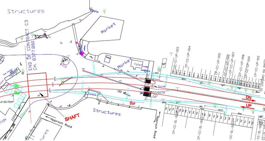
Phase IB
(Chandpole to Badi Chaupar: 2.4 kms/2 stations)
This phase is entirely underground and
located in the heritage city
It is being directly executed by JMRC, with
DMRC acting as General Consultant
Prime Minister of India laid the
foundation stone of Phase 1B on
21.09.2013.
M/s. CEC of Taiwan awarded tunnel &
station works, through ICB
Omikron (Greece) is the Structural Design
Consultant
AYESA (Spain) is the Detailed Design
Consultant for the project
TBMs by Robbins (USA)
6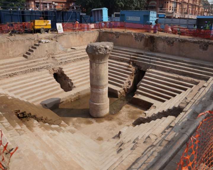
Construction Plan of the Project
Boring of 2.0 km-long twin tunnels of 5.6 meter internal diameter using Shield Earth
Pressure Balancing technique
2 underground stations constructed by cut and cover, top down method at Chhoti
Chaupar and Badi Chaupar
0.3 km Reversal line in Ramganj Bazar will also be constructed by cut & cover method
Dismantling of the two Chaupars and restoration to their original shape after
construction of Metro stations.
7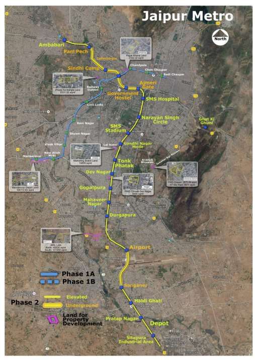
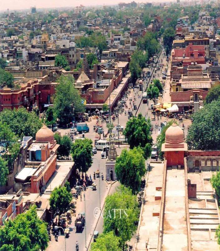
Walled City: Jaipur

                                                    Zorawar
                                                    Singh Gate

                                 New Gate
                   Ajmeri Gate

                                        Sanganeri
                                          Gate

Metro Route alignment and stations

                                                                                  8
Walled City: Jaipur

                 9
Planning & Preparation
1. Traffic Management during construction
Traffic diversion plan were prepared and got approved from traffic Police after
stakeholder discussions.
Barricades with reflectors were provided as per requirement
Marshals were employed wherever required to ease traffic movement
2. Preservation of heritage look and skyline
Entire section and both the stations are underground
Only entry/exit structure will be above ground and facia will be matched with the
heritage architecture
Detailed photography and videography of the two Chaupars, jointly with local bodies,
for exact restoration after construction of underground stations
3. Structural safety of the existing buildings & monuments
Well proven technology being used
• Earth Pressure Shield TBM for tunnels
• Top down construction technique for station and Cut & Cover Tunnel
4. Approvals
NOC from State Archaeology & Museum Department obtained
Joint Monitoring Committee set up for close monitoring 10Studies Undertaken
Environmental Impact Assessment study (EIA), with technical assistance from ADB
Safety, Health and Environment conditions of contract includes a Environment
Management Plan (EMP) and Environment Monitoring Plan (EMoP)
Anticipated Environmental Impacts and its Mitigation Measures
Numerous Physical Cultural Resources near tunnel surface center-line: Chandpole
Gate, Isar Lat or Sargasuli, Jantar Mantar and Hawa Mahal.
SN Monument Distance from nearest tunnel wall (in meters)
1 Chandpole Gate 0 Metres
2 IsarLat (Sargasuli) 10 Metres
3 Jantar Mantar 78 Metres
4 Hawa Mahal 46 Metres
Significant impacts:
• Vibration & ground settlement • Demolition & restoration of the Chaupars
• Surface noise from excavation • spoil disposal
• Chances of finding artefacts • groundwater extraction
• Dust emissions • disruption of essential services
11Studies Undertaken…contd
Impact of natural attenuation of sandy soil, vibration and noise reduction design
considered for the rail and train will not result to elevated vibration levels that will
cause cosmetic or structural damages to the PCRs.
The predicted ground settlement under the Chandpole gate.
To ensure the Contractor maintains vibration and noise levels, monitoring coupled
with trigger and allowable values were incorporated in the bidding documents.
Soil Investigation
Detailed soil investigation (29 bores) and a building condition survey were conducted
before taking up the work
The soil is poor in humus with very poor water-retaining capacity.
Ground Water
The ground water quality is poor at deeper levels.
The construction site area is notified as an overexploited area and is regulated by
Central Ground Water Board.
12Studies Undertaken…contd
Building Condition Survey
Building structures on 30 meters wither side of the metro alignment were surveyed
Around 3000 building structures were assessed
Based on the crack, structures were categorised into 6 categories namely, Severe, Very
Severe, moderate etc.
Seismicity
Jaipur City is classified under earthquake low damage risk zone II as per BIS.
GPR Assessment
Ground penetration radar used to detect buried artifacts, if any
13Challenges
14TBM : Tunneling work
15Challenges: TBM Under-passing Chandpole Gate
16Challenges: TBM Under-passing Chandpole Gate
17To Chandpole Station To Badi Chaupar
Legend :-
Alignment below the chandpole gate
18Chandpole gate Plan with Elevation
before Investigation
Ground Level = 439.941
Rail Level = 427.814
Overburden = 6.70 m (approx) 196.7 mt 6.7 mt
Water pipeline of 600mm dia and
350mm dia were found in
investigation. The flow of water was
blocked over the tunnel portion by
installing valves at both ends.
The gap between the crown of tunnel and bottom of foundation was approx 4.5m only.
Therefore, it was CRITICAL.
20Pressure from Media & Public
21Instrumentation Scheme for Monitoring
Automatic Deformation Monitoring System (ADMS)
Glass prisms were installed on the surface of Chandpole Gate and other critical
strcutres
Measurement were taken from the total station to these prism to convey possible
detected movement in the lateral plane (X,Y) and Vertical Plane (Z). (Trigger level 3
mm, Alarm level 4 mm)
Additional reference prisms were also installed on adjacent structures for effective
monitoring of Chandpole Gate.
This system is fully automated and in operation 24 hrs / 7 days a week. System is
equipped with SMS alert functions to warn of threshold limit breaches
Tilt Meter
Tilts meters were installed at the corners of the Chandpole Gate and other critical
structures to measure any tilt in the structure
Tilt sensor is epoxy pasted on the surface of structure and after setting of epoxy the
tilt sensor is screwed in bracket. A cable is extended to data logger location and
terminated in it for automatic monitoring
22Instrumentation Scheme for Monitoring
Crack Meter
Crack meters were installed on the surface of Chandpole Gate and other critical
structures for measuring the width of Crack in two directions i.e. inside and in UP
& DN
Pavement Settlement Marker
The pavement settlement markers were installed at site to monitor the vertical
settlement of road.
Trigger level 14 mm; Alarm level 18 mm
Monitoring frequency is once daily during excavation then once weekly
23Instrumentation Scheme for Monitoring
Multi Point Borehole Extensometer (MPBX)
Various Multi Point Borehole Extensometer (MPBX) were installed to accurately
measure distance between sensors with respect to reference plate and thus
monitor with passage of time their relative displacement in respect to each other.
Real Time Monitoring System
Server
Tilt
Meter
Monument Wireless link
ADAS Modem Modem
Crack
Meter
PC 24
PCInstrumentation Scheme for Monitoring
Crack Meter
Pavement Settlement Markers and Multi Point Borehole Extensometers Building Settlement Marker
Tilt Meter Pavement Settlement Marker
25TBM Online Monitoring
26Vibration & Ground Settlement
predictions for monuments
Vibration
The Peak Particle Velocity (PPV), a measure of vibrations, during Tunnel Boring attained
for each monument along the alignment is as under:
Archaeological TBM Source Rating PPV from TBM in
Monument PPV (mm/s) @ 1m mm/s
Chandpole Gate 10 0.682
Isar Lat 0.121
Jantar Mantar 0.00126
Hawa Mahal 0.00141
All these were much below the guideline value of 2.0 mm/s for historical buildings and
ruins.
Ground Settlement
Maximum settlement from tunnel boring during construction never exceeded trigger
value of 4mm and Alarm value of 5 mm.
27Challenges during Underground Station construction
CHOTI CHAUPAD
BADI CHAUPAD
RAMGANJ CHAUPAD
28Challenges during Underground Station construction
During the excavation at Chaupars for construction of underground Metro station,
old historic water tank were discovered.
Photograph of Chaupar taken during
early 1900s, showing old water tank
Photograph of Chaupar taken in 2011,
before start metro construction work,
showing water fountain
Photograph of Chaupar taken during in 2014,
showing excavated old water tank
29Old Water Tank found at Chaupars
30Proposed Urban Plaza at Chaupar over metro station
31Opportunities for Geospatial Technology
in Phase 2 of Jaipur Metro (Sitapura to Ambabari)
Geospatial Technology have become key tools for supporting transit business,
but have even greater use of these technologies will be required if transit
facilities have to meet the challenges of future.
32Status of Phase 2
(Sitapura to Ambabari: 23.8 kms)
DPR (July 2014) envisages that Phase 2 will
become operational in 2020.
Projected
Elevated UG UG Completi
Total Elevated
Length Length Total Stati on Cost
(km) Stations (Rs in
(km) (km) ona
Cr.)
23.8 13.8 10 20 13 7 10,394
International consultant M/s EGIS Rail (Lead),
M/s Egis India (JV) & M/s Feedback Infra JV
engaged to review DPR 2014 prepared by DMRC.
Laxmi Nagar
Airport Station
33Route mapping on
satellite Imagery
34Main Catchment Area of Phase 2 route
Sitapura: Industrial area and educational hub
Airport:Hotels
Tonk Phatak: Education institutes, High density commercial and residential area
SMS Hospital: Medical Institute & Main Hospital of Rajasthan
SMS Stadium: Recreational center, Educational institutes (coaching centers)
Ajmeri Gate: Entry to Heritage city area (Central Business District), Tourist
Spots
MI Road: High street of Jaipur (Main market of Jaipur)
Sindhi Camp: Inter State Bus Terminus, Railway Station, Interchange for Phase 1
Collectorate Circle: Collectorate, District Courts and other govt. offices
Ambabari: Vishwakarma Industrial Area, interchange for BRTS
35Geospatial Technology opportunity
Pre Construction
Optimized route identification
Identification of land for acquisition
Construction management
Traffic and Transport study
Multimodal transportation planning (e.g., travel demand forecasting),
Heritage Conservation (Monitoring of heritage structures)
Demography Analysis,
Environmental impacts.
Post Construction (O&M)
Scenario development/visioning,
Web-based user information systems,
Asset management systems including infrastructure maintenance
management and safety management (including accident analysis),
Intelligent transportation systems (ITS) applications
Corridor preservation/right of way,
36THANK YOU!
37You can also read