Aspects of 3D Cadaster in the New City of Modi'in, Israel
←
→
Page content transcription
If your browser does not render page correctly, please read the page content below
30 October, 2001
Aspects of 3D Cadaster in the New
City of Modi’in, Israel
Eng. Armi Grinstein
Armi Grinstein - Geodetic Engineering Ltd.
The Author is the general manager and owner of Armi Grinstein - Geodetic Engineering Ltd., one of Israel’s
leading and experienced companies in geodetic services. Geodetic engineer and a licensed surveyor, with 35
years of experience in Geodesy, Armi Grinstein has special expertise in Cadaster and is responsible for the
largest registration operation conducted in Israel by a private company.
Abstract
3 Dimensional Cadaster is a relatively new sphere in property registration, intended to
enable registration of underground and above-the-ground lands. This paper describes a large-
scale project, in the city transportation center of Modi’in, Israel, which includes buildings, bus
station and parking, a tunnel and railway station, roads, public areas and more. This complex
structure, with its many layers and different ownership, is a good example for construction
projects that could not be registered by orthodox Cadaster procedures. Further discussed is the
land registration system in Israel - its drawbacks and limitations. Finally, a short overview of
the work accomplished so far in this specific project and general progress in 3D Cadaster by
our office.
Introduction
Armi Grinstein – Geodetic Engineering Ltd., functions since 1991 as the site surveyor
of most parts of the new city of Modi’in, located amidst Tel-Aviv and Jerusalem (40
kilometers from Tel-Aviv), and currently being established. Our primary role is the
establishment and management of the entire planimetric and altimetric geodetic network in
the city, inside and outside construction sites in the neighborhoods.
2 Habonim St., Ramat-Gan, Israel, 52462 52462 ,גן- רמת,2 רח' הבונים
Fax: 5750127-03 :'פקס e-mail: armi@armig.co.il Tel: 5751755-03 :'טל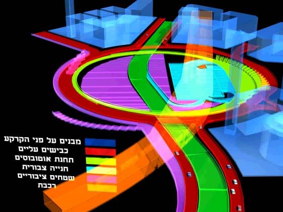
The city was developed in quarters containing 2,500 – 6,100 apartments (10,000 - 15,000
residents in each quarter). Between the years 1994 – 2001, the building of 16,000 apartments,
out of 24,100 planned for this stage, was completed (or reached last stages). The expected city
population is approximately 200,000.
Quarter Area Apartm Parcels Building Boundary Developm Constru
…ents Compan Points …ent …ction
…ies Budget Budget
[dunam] [million $] [million $]
A 920 3,900 142 - 751 - -
B 1,100 5,100 232 49 1,142 - -
C 1,900 3,000 243 33 1,226 - -
D 890 2,500 251 26 929 - -
E 2,200 6,100 409 28 2,170 - -
F 1,830 3,500 - - - - -
8,840 24,100 1,277 136 6,218 750 4,000
Table 1: Statistical Data (first stage) – the City of Modi’in
The legal registration process in Israel is usually executed by the building companies,
and is extremely slow. This process may take as long as 8 to 10 years, and sometimes even
more. Currently, more than 700,000 apartments in Israel are not registered. This constituted
the primary reason for the Ministry of Construction and Housing to initiate land registration in
this project by the site surveyor. This was a first experiment of its kind in Israel and was
concluded as very successful.
The land registration process in Modi’in was performed methodically, parallel to the
beginning of construction and separately for each quarter. As this registration is a primary
stage to common houses and tenant privileges registration, we intended to finish registration
of the division at the same time as the delivery of apartments to the tenants. In the years 1997,
1999 and September 2001 our company finished the registration procedures in quarters D, B
2 Habonim St., Ramat-Gan, Israel, 52462 52462 ,גן- רמת,2 רח' הבונים
Fax: 5750127-03 :'פקס e-mail: armi@armig.co.il Tel: 5751755-03 :'טל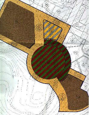
and E – approximately 13,000 apartments altogether. This is considered a very short period,
in Israeli standards, for such scales. We are currently working on quarter C and the main city
center, which also contains the city transportation center.
The City Center
The city center is planned to contain principal municipal functions, such as the city
council building, a museum, a theater, office and trade buildings, a hotel, academic college, a
library and the transportation center.
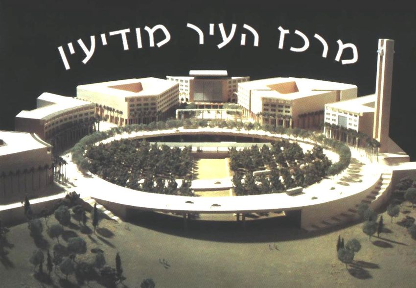
Figure 1: A Model of the Modi’in City Center
Establishment of the transportation center is divided into several stages: the first two
stages, which are supposed to last 48 – 60 months, include the structure of the center, roads
and the level of the bus station including all docks and ramps for entry and exit of busses and
pedestrians. This stage also includes the foundation of the underground railway station. The
third stage is intended to conclude all the work required for the operation of the underground
railway station, below the bus station level.
2 Habonim St., Ramat-Gan, Israel, 52462 52462 ,גן- רמת,2 רח' הבונים
Fax: 5750127-03 :'פקס e-mail: armi@armig.co.il Tel: 5751755-03 :'טלDuring the same 48 – 60 months of development in the city center, additional construction
will take place in all neighboring parcels, including buildings, access roads (mostly 2 - 3
levels) and mainly underground parking installations, some of which are 5 stories. According
to the city master plan, the building area in the city center will be approximately 100,000 sq.
meters and the roads and bridges approximately 40,000 sq. meters. The project was promoted
by the city council by not granting building permits, in the neighboring parcels, until the
completion of the first two stages of the transportation center.
The city transportation center, located in the main city center, will be mostly
underground and include the following layers or levels:
• Layer [-4] (+210m): A railway station with two platforms and entry and exit
tunnels.
• Layer [-3] (+216÷225m): A multi-level public garden.
• Layer [-2] (+221m): Central bus station and bus parking.
• Layer [-1] (+227m): A suspended access road to the bus station.
• Layer [0] (+232m): The surface / Public areas.
• Layers [1-5] (+256m): Public and commercial buildings.
This project’s estimated cost is 150,000,000 US$, with the principal part being the railway
station.
2 Habonim St., Ramat-Gan, Israel, 52462 52462 ,גן- רמת,2 רח' הבונים
Fax: 5750127-03 :'פקס e-mail: armi@armig.co.il Tel: 5751755-03 :'טלFigure 2: City Master Plan of the Main
City Center
Figure 3: Building Plan of the Main City Center
2 Habonim St., Ramat-Gan, Israel, 52462 52462 ,גן- רמת,2 רח' הבונים
Fax: 5750127-03 :'פקס e-mail: armi@armig.co.il Tel: 5751755-03 :'טלDescription of Land Ownership in the Main City Center
Land ownership in Israel usually falls under one of these categories: the State of Israel,
the Development Authority, Keren Kayemet le’Israel, municipal authorities or private
ownership. Generally, the process of re-division is relatively simple in cases of merging state
lands. Involvement of private lands complicates the process and Modi’in is no exception.
Most of the land in the city is owned by the state, apparently the easier scenario; however, the
registration process becomes very complex due to multi-level construction in projects such as
the city center.
Described below is land ownership, according to the specified layers:
• The State of Israel will own the railway station.
• The Municipal Authority will own the public garden.
• The Municipal Authority will own the bus station, after expropriation according to
the real estate statue – 1969, sub-sections 5, 7, 19, and leased for a long term (49
years) to the bus transportation company.
• The Municipal Authority will own all the suspended and ordinary roads.
• The Land Development Authority will own the parcels on the ground, with the
option to sell them to private investors.
• The State of Israel, the Land Development Authority or the Municipal Authority
will own the public areas and buildings.
The Current Land Registration System in Israel
Current statues allow land registration in layers only according to property registration
in common houses. This type of registration is 2D and in best scenario describes an average
layer, upon which all the layers are projected. Elements between layers, such as: access
ramps, ventilation shafts, elevators, moving stairs and others, are overlooked.
The current land registration system has several technical and legislative limitations
requiring changes:
• Current surveying regulations (1998) enable surveys and inspection of registration
programs in 2D only. Beyond planar coordinates, these programs do not contain
2 Habonim St., Ramat-Gan, Israel, 52462 52462 ,גן- רמת,2 רח' הבונים
Fax: 5750127-03 :'פקס e-mail: armi@armig.co.il Tel: 5751755-03 :'טלany information regarding heights. Land registration is also in 2D. A change in
legislation, enabling 3D surveying and 3D program inspection by the Survey of
Israel, is essential.
• When regulations for 3D registration do not exist, the only practical option is
registration as apartments in a common house. Can we really define a house as: “a
multi-layer building including an underground railway station, a bus station, a
complex road system, a commercial center and a hotel”?
• Currently, land division on the surface extends to the earth’s center (according to
the real estate statue – 1969, sub-section 11). When parcels on the surface have
only one owner, they can be merged and then the sub-surface can be regarded as a
single unit. However, how can we cope with multiple ownerships? Is the
ownership extension from the surface to the sub-surface still practical?
• Some statutory arguments state that the dependence between the surface and the
sub-surface is stronger than the dependence between neighboring parcels on the
surface. In case of a deep underground tunnel, a functional disconnection is
possible. This solution was adopted for the transportation center (the tunnel is 30
meters below the surface), but can not apply where the tunnel gets proximate to the
surface.
The Survey of Israel states that all future Cadaster will be digital. As all 3D mapping
will also be digital, preliminary adjustment of the 2D Cadaster to 3D Cadaster is essential.
Regarding the financial issue of establishing the future 3D Cadaster, the most logical solution
is to finance the project by landowners that will benefit from realizing their underground real
estate.
Land Registration of the Transportation Center and the Main City Center
As previously mentioned, our company executed the land registration in Modi’in after
the accomplishment of planning and with the beginning of construction. The registration
process can only begin after the approval of the city master plans, which may take up to 2 – 3
years. The authorization process of the plan regarding the city center started in1998 and is
about to be completed next month.
2 Habonim St., Ramat-Gan, Israel, 52462 52462 ,גן- רמת,2 רח' הבונים
Fax: 5750127-03 :'פקס e-mail: armi@armig.co.il Tel: 5751755-03 :'טלIt was obvious to us that the conventional 2D registration procedures where
inappropriate for the registration of the multi-level city center. Our conclusion was enhanced
by the fact that most of the spaces in the city center master plan, defined by the Safadi
architects office from Boston, Massachusetts (USA), could not be registered.
In March 1999 we visited the Norwegian National Mapping Authority and studied the
Norwegian approach towards 3D Cadaster in Oslo. In late 1999 we presented our company’s
preliminary approach to 3D surveying and mapping and the ability to present 3D underground
objects, based on conventional surveying, in a surveying conference in Haifa, Israel.
3D measurements are practically executed regularly for many years, but are not
exploited for registration plans due to the fact that Israel surveying regulations for registration
plans only require planimetric presentation and thus heights are omitted.
Surveying in the transportation center is executed in 3D and all measurements, above or under
the ground, with either Total-Stations or GPS receivers, are connected to the national control
network for position and height. The more complicated issue is visualization of the project
and the 3D registration plans, specifically to offices involved in the registration process, such
as the Survey of Israel and the Bureau of land registration in the Ministry of Justice.
After the field surveying was accomplished, we executed computations, drawing of 3D
architectural plans and 3D visualization. The animation of the city center was prepared with
the 3D Studio software by Kinetics. It includes production of a short video based on a model
and 1,450 perspectives, to visualize the different layers and separate objects in the city center.
The first perspective is shown in figure 4. This, however, is not an optimal solution and we
currently focus on analysis of different software for 3D CAD and visualization.
2 Habonim St., Ramat-Gan, Israel, 52462 52462 ,גן- רמת,2 רח' הבונים
Fax: 5750127-03 :'פקס e-mail: armi@armig.co.il Tel: 5751755-03 :'טלFigure 4: Visualization of the layers in the City Center
Conclusion
3D Cadaster is at our fingertips; surveying, computation and drawing technologies and
techniques are long and well known. State efforts should be concentrated on legislation and
assimilation of those technologies and techniques among surveyors and professional
government departments responsible for mapping, program inspection and ownership
registration.
2 Habonim St., Ramat-Gan, Israel, 52462 52462 ,גן- רמת,2 רח' הבונים
Fax: 5750127-03 :'פקס e-mail: armi@armig.co.il Tel: 5751755-03 :'טלYou can also read