Tamworth Borough Integrated Transport Strategy 2015 2031 - June 2015 - Staffordshire ...
←
→
Page content transcription
If your browser does not render page correctly, please read the page content below
Tamworth Borough
Integrated Transport Strategy
2015 - 2031

June 2015

TAMWORTH BOROUGH
INTEGRATED TRANSPORT STRATEGY 2015-2031

1.   Introduction

1.1 Integrated Transport Strategies have been developed for the eight District / Boroughs
    in Staffordshire to help prioritise the County Council’s expenditure on transport
    improvements and secure potential resources including developer contributions and
    Government funds. They are also informing the Local Plan process.

1.2 The Government has confirmed its commitment to devolving economic power to
    Local Enterprise Partnerships (LEPs) through the creation of a Local Growth Fund
    (LGF) which has been formally allocated to the LEP through Growth Deals. European
    funds may also become available for transport through Growth Deals.

1.3 A significant level of transport funding has been transferred to the LGF as transport
    has been identified as central to local economic development. Allocations of LGF and
    European funds to the Greater Birmingham and Solihull LEP and Staffordshire and
    Stoke-on-Trent LEP have been determined through each LEP’s Strategic Economic
    Plan (SEP) for the period 2015/16 to 2020/21. Allocations have been based on the
    strength of the Strategic Economic Plans in terms of identifying effective and speedy
    delivery of transport schemes and robust evidence of value for money.

1.4 LEP Growth Deals were announced in July 2014 with Stoke-on-Trent and
    Staffordshire LEP (S&SLEP) receiving a minimum of £82.3m over the 6 years of the
    SEP. A provisional allocation of £5m from the Local Growth Fund has been identified
    to invest across the S&SLEP area for sustainable transport packages to make urban
    centres like Tamworth more competitive. Following a second round of the S&SLEP
    Growth Deal total funding now stands at £97.7m, with additional investment
    earmarked to create an enterprise quarter in Tamworth.

1.5 Tamworth Borough Council is also a member of the Greater Birmingham and Solihull
    LEP, and therefore, cross border working through the respective LEP governance
    arrangements is essential to maximise investment in the Borough.

1.6 The Tamworth Borough Integrated Transport Strategy helped to inform both SEPs,
    and will continue to support bids for future rounds of LGF as it is allocated.

1.7 Delivery of this transport strategy will help achieve the County Council’s vision of ‘A
    Connected Staffordshire’: ‘where everyone has the opportunity to prosper, be healthy
    and happy’. It will also help to deliver the County Council’s three Priority Outcomes.
    For Staffordshire’s residents to be able to:

            Access more good jobs and the benefits of economic
            growth

            Be healthier and more independent

            Feel safer, happier and more supported

1.8 The Health and Wellbeing Agenda is a high priority for Staffordshire County Council
    and will be supported through capital investment in the walking and cycling network
including the National Cycle Network and promotional activities delivered through
Local Sustainable Transport Funding (LSTF) and other funding sources as they
become available. Active Staffordshire has also been established to increase
participation in physical activity across the County.
1.9 In 2011, we consulted communities and stakeholders on the integrated transport
strategies. Many useful comments and ideas were received which have helped to
shape this strategy for Tamworth Borough. Our response to all representations is
provided in: Report on the Outcome of the Consultation Process 2011/12 at:
http://www.staffordshire.gov.uk/transport/transportplanning/localtransportplan/districti
ntegratedtransportstrategies.aspx
1.10 Comments during the consultation process focused on rail improvements including
proposals for a new ‘local train service’ to serve Tamworth, relieving overcrowded
Cross Country services, and support for measures to reduce pressures on the trunk
road network, particularly the A5(T). Bus operator Arriva advised that public transport
improvements should be delivered in conjunction with measures to reduce the
impacts of traffic congestion.
1.11 The County Council continues to take into account new data, information and the
views of stakeholders through ongoing dialogue and interaction. These include
Tamworth Borough Council, Highways England, local interest groups, the general
public and, of course, local elected representatives.
2. Borough Profile
2.1 Tamworth Borough contains a population of 76,000 residents within an area of 12
square miles located 18 miles North of the West Midlands Conurbation. The town has
a compact urban form with a network of green linkages and a development pattern
focused around connected neighbourhoods and centres, providing good opportunities
for sustainable travel.
2.2 Some 26,000 people work in Tamworth and whilst manufacturing is still important, the
majority of jobs are now in the service industry. Despite good levels of employment,
around 18% of the population live in areas that are classified amongst the most
deprived in England.
2.3 In terms of health issues, around 3 in 10 adults in the Borough are classified as
obese, considerably worse than the national rate and there has been an upward
trend in recent years.
2.4 Tourism and retail play an important role in the Borough’s economy. Visitor
attractions include a Norman Castle in the town centre, Snowdome, Ventura Retail
Park and Drayton Manor Theme Park (in Lichfield District).
2.5 Tamworth has good connections to the national transport network. The A5(T)
provides links to Cannock, Nuneaton, the M42 and the M6 Toll. The A51, A513 and
A4091 are important routes along the local highway network and run north-south
through the Borough. It is estimated that 50% of the working population out-commute
each day to work and 69% of employed residents drive to work.2.6 Tamworth rail station is located in close proximity to the town centre, whilst Wilnecote
station is to the south of the town centre near Two Gates. Both rail stations are
located on the Cross Country line between Birmingham / Tamworth / Burton upon
Trent / Derby and Nottingham. Tamworth station is also located on the West Coast
Mainline providing connections to the major cities of London, Coventry, Birmingham,
Manchester, Liverpool, Glasgow and Edinburgh. Both Tamworth and Wilnecote
stations are currently managed by London Midland. Services are operated by Cross
Country Trains, London Midland and Virgin Trains. Services to London operate hourly
in the off peak with additional faster services in the peak periods, whilst there are
approximately three trains per hour connecting to Birmingham in the off peak with
four per hour in the peak periods. There is significant passenger and freight demand
along both corridors, although there is no dedicated local service on the Cross
Country line so demand is catered for by stops on the Nottingham to Birmingham
service and by less frequent stops of longer distance services. Passenger numbers at
Tamworth station increased by over 33% between 2006/07 and 2013/14. This
increase is likely to be attributable to the more frequent local services on the West
Coast Main Line. According to the 2011 Census around 2% of Tamworth residents
use the train to access their employment.
2.7 Tamworth has an extensive cycle network covering 30 miles within a 12 square mile
area, including a network of off-road links. However according to the 2011 census
data, only 2% of residents in Tamworth cycle to work whilst 9% walk.
2.8 The Borough is served by a core bus network of local and inter-urban routes to
Lichfield, Warwickshire and the West Midlands conurbation, supported by community
transport services. The 2011 Census indicates that 4% of residents in Tamworth
travel to work by bus. This bus service use is one of the highest in Staffordshire,
hence the high frequencies of town services that generally operate every 12 minutes.
Bus reliability surveys have indicated that nearly 93% of services depart on time and
accessibility to Tamworth town centre is good with the majority of households within a
20 minute door-to-door travel time.
3. Recent Transport Achievements
3.1 In recent years there has been a considerable reduction in Local Transport Plan
(LTP) funding available for transport schemes throughout the County. Efforts have
therefore been focused on making the best use of the existing highway network,
concentrating on maintaining its condition and ensuring that we continue to reduce
road casualties.
3.2 A successful bid made by the County Council for Local Pinch Point Funding in 2014
secured some £1.376m which, together with a local developer contribution of
£600,000, has allowed highway capacity and safety improvements to be delivered
along the Gungate/Aldergate Corridor. Improvements completed at the Fountains
junction, Lichfield Street/Aldergate junction and the Upper Gungate/Croft Street
junction in 2014/15 will provide additional capacity to help make new residential
development in Anker valley and Browns Lane acceptable in transport terms.
3.3 In 2013/14, approximately £450,000 was spent on undertaking transport
improvements and investigations as well as delivering the bridge and highway
maintenance programme throughout the Borough. This includes access
improvements for Lichfield Road Industrial Estate, junction modifications at VenturaRetail Park, bus access improvements on Route 3 (Tamworth Town Centre to Coton
Green) and detailed design work for interventions on the Gungate/Aldergate Corridor.
3.4 Over the last three years a number of significant transport interventions have been
implemented around Ventura Retail Park using both developer and public funding.
Significant improvements to the Jolly Sailor and Sainsbury’s roundabouts, together
with a new vehicular exit onto Bonehill Road, have helped to improve highway
capacity and ease longstanding congestion issues. Access to the retail park by
sustainable modes has been enhanced. Along the route between Ventura Retail Park
and the town centre a new pedestrian crossing facility has been provided and the
existing frequent bus service (Route 6) has been rebranded and new bus shelters
provided to serve new developments.
3.5 Targets to reduce road casualties are being achieved through education,
enforcement and engineering measures. Safety in the Borough has been improved
through the delivery of measures such as anti-skid surfacing, vehicle actuated signs
and 20 mph speed limits outside schools.
3.6 The vast majority of Tamworth’s bus services are commercial and have been
maintained throughout recent years. In Tamworth 92.6% of addresses are located
within 350 metres of a half hourly or more frequent weekday bus service. Many bus
stops now comply with the Equalities Act 2010. Staffordshire County Council is also
the national leader in discretionary travel allowance and free 24/7 bus transport is
available to people of pensionable age or with a disability, plus their carer. The
innovative ‘Your Staffordshire Card’ allows under 20s to travel anywhere within
Staffordshire for just £1.20 per journey.
3.7 In recent years the main operator Arriva has invested over £2 million on new fleet.
Buses used in the town services were upgraded in 2012 and there are further new
buses now operating to Arriva’s ‘Sapphire’ high specification for the 110 service from
Tamworth to Birmingham which were introduced in 2014. The new vehicles are fitted
with Wi-Fi, leather seats, mobile charging points and have next stop announcements.
3.8 In the last two years new bus services have been introduced between the town
centre and Birch Coppice Employment Area in nearby North Warwickshire. These
are operated to a pattern co-incident with shifts thereby connecting Tamworth
residents to job opportunities.
3.9 In terms of recent rail improvements, the West Coast Mainline which carries a
mixture of long distance, local and freight services has seen significant investment to
increase capacity. In recent years a regular interval service between Crewe and
London via Stoke, Stafford, Lichfield, Tamworth and Rugby has been introduced
which has significantly improved connectivity between key locations.
3.10 Works at Tamworth Rail Station were completed in January 2013 through the
National Stations Improvement Programme including improved waiting areas, wash
room facilities and booking hall, new lighting, CCTV, improved access to platforms
and cycle parking provision.4. Tamworth Borough Council Pre-submission Local Plan 2006-2031
4.1 Tamworth Borough Council’s Local Plan will be examined in June 2015. Within the
plan period it proposes the following levels of residential and employment
development across the Borough:
• A forecast housing requirement of 250 homes per year equating to 6,250 in total.
• A total employment requirement of 32ha together with a etail requirement of
7,800m2 of new comparison retail floor space and 2,900m2 new convenience
retail floor space.
4.2 The Plan identifies a total of 18ha of land suitable for employment uses within the
Borough (Policy EC6). The remaining 14ha is expected to be found beyond the
Borough boundary within Lichfield and North Warwickshire.
4.3 Policy EC7 identifies an existing network of strategic employment areas for this
provision. The explanatory text also recognises the importance of revitalising these
areas:
• Bitterscote (Bonehill Road, Cardinal Point, Bitterscote South)
• Tame Valley Employment Area (Hedging Lane, Two Gates, Tame Valley
Industrial Estate)
• Amington Employment Area
• Lichfield Road Employment Area
• Centurion Park Employment Area
• Relay Park Employment Area
4.4 Of the 6,250 new homes identified in the Pre Submission Local Plan around 2,323
will be located on three Sustainable Urban Extensions (SUEs) (identified in Policy
HG2) with the remainder (1,937) provided on smaller sites within or adjacent to the
existing urban area (identified in Policy HG1). A minimum of 2,000 new homes will be
required outside of the Borough boundary within Lichfield and North Warwickshire
Districts to meet Tamworth’s objectively assessed housing need.
4.5 The Sustainable Urban Extensions identified (Policy HG2) are the Golf Course (1100
new dwellings), Anker Valley (approximately 500 new dwellings) and Dunstall Lane
(up to 750 new dwellings). Sustainable Urban Extensions are recognised as more
than just housing and will require delivery of supporting infrastructure to create a
sustainable, inclusive community with good access by all modes of transport.
Internal trips will need to be maximised (contained) through provision of services and
facilities on-site.
Dunstall Lane SUE
4.6 Pre-application discussions have commenced with respect to this key site which will
provide up to 750 new dwellings, a new primary school as well as local retail facilities.
Two points of vehicular access will be required with the primary access proposed to
be from Ventura Park Road/ Meadow Road roundabout junction. The Transport
Assessment study area includes the highway network in and around Ventura Retail
Park, including the junction with the A5(T), as well as the A51/B5493 roundabout and
the A5/A453 Mile Oak junction.4.7 Staffordshire County Council’s traffic model for Ventura Retail Park will be used to
assess the traffic impacts of the site on the surrounding local highway network and
identify any capacity improvements required. Accessibility software (Visography
TRACC) has also been applied to demonstrate how the site could be made
accessible by sustainable modes and advice has been provided to the applicants.
4.8 It is proposed that bus service 6 will be extended to serve this development via an
internal loop road. The applicants have also offered to provide new and enhanced
pedestrian and cycle links into some of the surrounding areas including Ventura
Retail Park and to the Birmingham and Fazeley Canal.
4.9 The County Council has submitted a representation in response to Tamworth
Borough Council’s Pre-Submission Local Plan identifying an additional requirement
for improved pedestrian and cycle connectivity to the north of the site linking through
to the A51 Lichfield Road. This would provide improved access to education,
employment and retail areas for local residents. Accessibility analysis shows that this
improvement would significantly increase opportunities for sustainable travel and
enhance the overall accessibility of the site.
Tamworth Golf Course SUE
4.10 The site is located just within Tamworth Borough directly adjacent to the North
Warwickshire Borough boundary. A planning application for 1100 dwellings, a two
form entry primary school and a local convenience store has been submitted, but has
yet to be determined. The developers are proposing two points of vehicular access
via a new junction onto Mercian Way and utilising the existing golf course access
from Eagle Drive. Road widening works to Mercian Way are required to
accommodate development traffic at the two points of access.
4.11 The Transport Assessment for the development considers 16 local highway junctions
including Mercian Way/Glascote Road, Pennine Way/Watling Street/A5 roundabouts,
A5/Marlborough Way and A5/Ventura Park, as well the traffic impacts on a number of
key highway links such as Mercian Way, Glascote Road and Pennine Way. New right
turn bays at both site access junctions on Mercian Way will be provided to minimise
traffic delays and modifications to the Glascote Road/Marlborough Way roundabout
junction will also be required. The County Council has raised concerns over traffic
capacity issues on the local highway network relating to junction 10 of the M42 and
the A5/Marlborough Way junction which will require further assessment.
4.12 In terms of sustainable transport it is likely that local bus service 5 (currently every 12
minutes) will need to be routed through the development. This will ensure satisfactory
access to the retail area and primary school as well as providing a frequent link to the
town centre and Tamworth rail station. A new pedestrian and cycle route will border
the site connecting to the Coventry Canal cycle route. Other pedestrian and cycle
connections will link the site to Mercian Way. Crossing facilities will be provided on
Mercian Way to improve access for pedestrians and cyclists. Cycle parking facilities
will be provided at key locations within the site.
Anker Valley SUE
4.13 Outline planning permission has been secured for 535 new dwellings at the north
eastern edge of Tamworth as well as a small retail unit and a primary school.Vehicular access will be secured via two new junctions on the B5493 Ashby Road, a
roundabout to the north of the site and a priority junction to the north-west.
4.14 It is considered that pedestrian links could be provided to the south of the site to
improve access to the town centre and rail station as opportunities arise. A new
footbridge is proposed over the Birmingham to Derby (Cross Country) railway line. If
this is provided in a central location it will allow access to Perrycrofts Crescent to the
west of the site leading to local schools and a 30 minute frequency bus service
linking to the town and Tamworth rail station within a 350m walk. However if the
footbridge is provided in close proximity to the Ashby Road Railway bridge, none of
the site will be able to access local bus services within a 350m walk, and service 2
will need to be diverted into the development.
4.15 The Transport Assessment identified capacity improvements were required to
mitigate traffic impacts at the A513 Comberford Road/Gillway Lane/Coton Lane,
A513 Comberford Road/Wigginton Road/B5493 Ashby Road/A513 Upper Gungate
(Fountains Junction) and the A513 Upper Gungate/Salters Lane/Offadrive/Aldergate
junctions. A proportionate contribution to the cost of the Pinch Point works
implemented in 2015 to junctions along the Gungate/Aldergate Corridor has been
secured.
Coton Lane
4.16 This is one of the larger sites covered by Policy HG1 and a planning application has
now been submitted for 170 homes on land at Windmill Farm. The Transport
Assessment proposes vehicular access onto Coton Lane being achieved via two new
priority junctions and recommends improvements to the nearby Fontenaye Road and
Claremont Road junctions.
4.17 It also considers the traffic impact at Coton Lane/A513 Comberford Road/Gillway
junction, the A51 Lichfield Road/Coton Lane junction as well as the A51 Lichfield
Road/Park Street/Moor Street/A51 Tamedrive junction in terms of traffic capacity.
However impact on the sensitive Gungate/Aldergate Corridor will need to be
assessed using the County Council’s traffic model in order to establish whether all
traffic impact can be satisfactorily accommodated on the Local Highway Network.
4.18 Finally the proposed development will also need to provide improved local bus stop
infrastructure, including Real Time Passenger Information, shared pedestrian and
cycle facilities linking to Rawlett school and pedestrian crossing facilities adjacent to
the site across Coton Lane.
Residential Development in Lichfield District for Tamworth’s Needs
4.19 The Lichfield District Council Local Plan Strategy (2008-2029) was formally adopted
on 17th February 2015 and includes a North of Tamworth Broad Development
Location with capacity for 1000 homes, 500 for Tamworth’s needs.
4.20 A development of 165 homes within Lichfield District on land North of Browns Lane
already has the benefit of full planning permission. The mitigation package includes
new pedestrian crossing facilities, public transport infrastructure improvements, and a
financial contribution towards the Gungate/Aldergate Corridor Pinch Point Scheme.Modifications to the Coton Lane/A513 Comberford Road junction will also be
delivered.
4.21 A second planning application for up to 1,000 dwellings in Lichfield within the Broad
Development Location is currently awaiting determination by Lichfield District Council
(LDC). Tamworth Borough Council and Staffordshire County Council have made
objections regarding the potential transport impact of this additional development
within Tamworth. Concerns relate to the prospect of unacceptable levels of
congestion at peak times along the sensitive Gungate Corridor which has recently
been improved to facilitate the 700 homes at Browns Lane and Anker Valley.
Deletion of the Anker Valley Link Road from the Pre-Submission version of the plan
(due to lack of viability) means that options to provide significant additional highway
capacity within this corridor are limited. The results of the respective traffic modelling
exercises for the improved Gungate/Aldergate Corridor are widely divergent; the
County Council forecasting congested conditions, whilst the applicants forecast
acceptable conditions but based on unrealistic assumptions. Staffordshire County
Council and the applicants Barwood Strategic Land are working together to agree the
details of a revised traffic modelling exercise, based upon the actual performance
being delivered by the Gungate/Aldergate Corridor improvements ‘on the ground’. It
is hoped this latest initiative will define how many of the proposed 1,000 homes can
be made acceptable in transport terms. The applicants are also investigating whether
further highway capacity improvements are feasible. It is understood that once these
issues have been resolved or discussions can go no further LDC will determine the
application.
4.22 The three Local Planning Authorities have embarked on a workstream to establish
where in Lichfield and North Warwickshire Districts the remaining residential capacity
can come forward to meet Tamworth Borough’s objectively assessed housing need.
Economic Regeneration
4.23 To boost economic growth in Tamworth town centre, a Masterplan has been
developed by the Borough Council recommending that improved links should be
made between Ventura Retail Park and the town centre. The Borough Council is also
seeking to bring forward key development opportunities, working with partners on
town centre regeneration proposals delivering 400 jobs, including Gungate
regeneration site and the Cultural Quarter and Heritage Economic Regeneration
Scheme.
4.24 Investment in Tamworth’s local and neighbourhood centres will meet local needs
sustainably and reinforce their roles as community hubs. This will be focused on the
most deprived areas as well as the Wilnecote Corridor.
5. Transport Evidence to Support Tamworth’s Emerging Local Plan
5.1 Accessibility advice concerning the local plan proposals and residents’ ability to travel
to a range of services was provided in 2014. In summary:
• Accessibility by sustainable modes, including public transport and walking, is
generally good in Tamworth to a wide range of services and facilities. The
only exception being access to the hospital as for many residents this involves
an interchange in the town centre to an hourly frequency service. This is dueto the location of the hospital at the edge of the urban area.
• Areas around the two rail stations have access to the greatest number of job
opportunities. Parts of Stoneydelph around Watling Street and parts of
Hockley show consistently longer travel times than other residential areas.
The bus that serves Watling Street operates a hourly frequency and uses a
one way route that in this area is travelling away from the town centre before
routing along Pennine Way.
• Hockley estate has the most frequent town service into Tamworth with a bus
every 10 minutes on services 8/9, but the journey time from the bottom of the
estate around Overwoods Road is the longest of any town service into
Tamworth due to the service operating via all the estates around Wilnecote
and Belgrave so journey times to key services from this area are much longer
than from other estates.
• Coton Lane and Anker Valley residential development sites have public
transport access utilising the existing bus services. Coton Lane accesses
service 3/3A which provides a combined frequency of every 15 minutes
travelling two different routes to the town centre. Anker Valley utilises service
2 that operates every 30 minutes.
• The Golf Course and Dunstall Lane sites have limited existing public transport
access due to the location and size of the sites. Proposed public transport
improvements have been developed and tested using Visography Tracc to
demonstrate that the whole site can be made accessible by public transport;
dependent on site layout.
• The Draft Local Plan proposes employment development which forms
extensions to existing employment areas. The Bitterscote South development
is separated from existing employment areas by the A5 and due to its location
does not have existing public transport accessibility. A proposed bus service
extension to service 780 to serve the site shows that the site can be made
accessible; dependent on site layout.
5.2 An analysis of 2013/14 Department for Transport GPS Trafficmaster data was used
to assess travelling conditions (including estimating delays) experienced by road
users on key routes in Tamworth. The following conclusions can be drawn:
• The worst delays occur during the AM peak hour but for the majority of routes
delays are higher during the PM peak.
• There is traffic congestion at Ventura Retail Park with delays on roads at
Saturday peak times ranging from 0.5 to 10 minutes. The worst delays are
experienced on Ventura Park Road westbound, the main retail access across the
site.
• Prior to the Pinch Point works, the Upper Gungate corridor operated over
capacity. Ashby Road in particular and Comberford Road showed consistently
high delays during the AM peak. They are the least reliable routes in Tamworth
experiencing variable travelling conditions.
• Peak PM delays tend to be experienced on local routes to the A5(T) such as
Hints Road, close to the A5(T) Mile Oak junction, Sutton Road and Marlborough
Way.
5.3 In 2012, Staffordshire County Council commissioned JCT Consultancy Limited to
undertake two transport studies in Tamworth, one to consider highway capacity and
traffic movements around Ventura Retail Park and the second to assess the
operation of junctions along the Gungate / Aldergate Corridor and establish apackage of improvements to reduce congestion and create capacity for new housing.
The Ventura Retail Park study identified a package of measures that are now
progressively being delivered to improve traffic flows and reduce delays at peak
times. The Gungate/Aldergate study recommended a package of local improvements
to the Gungate/Aldergate Corridor to reduce congestion and increase journey time
reliability and enable around 500 additional dwellings to be provided to the North of
Tamworth.
5.4 To inform the Local Plan making process, a further report was produced by BWB
Consultants to assess and apprise a number of potential transport packages to see if
any might deliver a strategic development of up to 2,400 houses in Anker Valley and
a broad development location North of Tamworth. The conclusions suggest that up to
700 dwellings could be developed with a sustainable transport package, although
further work would be required to identify the most appropriate transport package to
deliver this increase from 500 to 700 dwellings.
5.5 BWB Consultants also advised Tamworth Borough Council that an Anker Valley Link
Road (included in an earlier version of the Plan) would only deliver 1,350 dwellings in
total and furthermore was not viable as a privately funded initiative. Therefore it has
not been included as a proposal within this Transport Strategy or the Pre Submission
Local Plan.
6. Transport Strategy
6.1 The Integrated Transport Strategy Summary Table in Appendix 1 illustrates how we
intend to deliver the following Economic Prosperity and Community priorities of
Tamworth Borough and the Priority Outcomes of the County Council’s Strategic Plan
as detailed in paragraph 1.5. The Integrated Transport Strategy has also guided the
Stoke-on-Trent and Staffordshire, and Greater Birmingham and Solihull Local
Enterprise Partnerships’ Strategic Economic Plans.
ECONOMIC PROSPERITY
• Accommodating proposed brownfield and Sustainable Urban Extensions
• Manage congestion and reduce carbon emissions on the local network and A5(T)
• Support retail and housing growth and job creation in the town centre that
compliments Ventura Park
• Improve public transport connectivity to the West Midlands conurbation
• Provide sustainable transport connectivity to key destinations throughout the urban
area
COMMUNITIES
• Maintain the current condition and safety of the highway network
• Improve public transport connectivity and quality of life for local communities
• Raise awareness of environmental issues and encourage people to lead more
sustainable lifestyles, helping to reduce carbon emissions
6.2 Priorities will be delivered through a combination of countywide initiatives,
connectivity proposals, schemes identified in the Divisional Highway Programme andimplementation of Local Transport Packages. The delivery of the Local Transport
Packages will be linked to the phased delivery of local development proposals, in line
with the Local Plan once adopted and available resources. The Strategy is
summarised in Appendix 1 and illustrated in Figure 1.
6.3 All new developments that are predicted to generate significant levels of traffic will be
required to produce and deliver a Travel Plan. In order to further reduce forecast
traffic levels, existing businesses in Tamworth will be encouraged to develop
Workplace Travel Plans that promote initiatives such as car sharing, sustainable
travel, personalised journey planning, teleworking and flexible working hours.
Targeted marketing initiatives in Tamworth will include a combination of travel advice,
discounted public transport tickets, better public transport information and local
community events promoting walking and cycling. Schools in Tamworth will also be
encouraged to have Travel Plans in place during the plan period. All behavioural
change initiatives will be funded by developers (through S106 and Community
Infrastructure Fund) supported by Local Sustainable Transport Funding, other public
funds and grants as resources permit.
Divisional Highway Programme
6.4 The Divisional Highway Programme for Tamworth Borough gives Local County
Councillors the opportunity to directly input into delivery programmes. Councillors
work closely with Community Highway Managers and other key stakeholders to
ensure local concerns and challenges are identified and priorities are established,
taking into account financial constraints. The Divisional Highway Programme is
reviewed twice a year and gives an overview of highway and transport concerns
within the local area, such as pedestrian safety, excessive vehicle speeds, on-street
parking and safety at junctions. The main DHP issues raised by Tamworth
Councillors are summarised in Appendix 1.
Connectivity in the Borough
6.5 Enhanced connectivity in the Borough will be achieved through continued partnership
working with key stakeholders including the LEPs, public transport operators and
Highways England (formerly the Highways Agency), involvement with the A5(T)
Transport Liaison Group and cross boundary working with West Midlands authorities,
for example the Regional Rail Forum. The A5(T) Transport Liaison Group has been
established to ensure that the A5(T) plays its role in facilitating economic growth
through maximising capacity and improving safety.
6.6 Highways England (HE) has previously identified that junction improvement schemes
for the A5(T) at Mile Oak, within Lichfield District, and Stoneydelph may be required
to accommodate Tamworth’s future development proposals, subject to feasibility
studies. Highways England does not consider that there are currently significant
capacity or safety issues at Stoneydelph but there are issues at Mile Oak in the
Saturday peak period caused by traffic generated by Ventura Retail Park. The County
Council will continue to seek inclusion of these schemes in any updates of Highways
England’s Route Investment Strategies.
6.7 The County Council has produced a Rail Strategy which will be published in July
2015 to compliment the Tamworth Borough Integrated Transport Strategy. During
the development of the Rail Strategy a rail summit was held together with variouspublic consultations to help confirm policy support and identify priorities for rail
investment. There are aspirations for a new local train service for Tamworth to be
introduced. This will relieve overcrowded Cross Country services and will provide
additional capacity for local commuters and capacity enhancements to the line
between Birmingham and Tamworth as well as the potential for a turn back siding for
the new local service at Tamworth.
6.8 To enable additional local rail services to be introduced between Tamworth and
Birmingham City Centre capacity constraints at Water Orton and into Birmingham
must firstly be overcome. The preferred solution, required during the next control
period (CP6 2019-24) will need to be sufficient enough so that it not only delivers the
necessary capacity improvements already identified for freight and passenger
services but also delivers the local connectivity aspirations along the corridor i.e.
local passenger services to and from Burton upon Trent, Tamworth, Birmingham,
Nuneaton and Leicester.
6.9 Further improvements at Tamworth rail station have been identified and could
include forecourt improvements, increased car park capacity, enhanced signing and
lighting, information maps, expansion of pedestrian areas, improved footways and
crossings and public realm in the vicinity of the station. Pedestrian and cycle links
from the town centre and educational establishments on Upper Gungate to
Tamworth rail station are also proposed. The emerging Staffordshire Rail Strategy
also identifies improved pedestrian access to Wilnecote rail station as well as
proposals to lengthen the platforms to accommodate longer trains.
6.10 The County Council has indicated its opposition to the Government’s proposals for a
High Speed Rail link through the County. Notwithstanding this, the importance of
engagement with HS2 Ltd to ensure that Staffordshire’s communities and
businesses obtain maximum mitigation is recognised. HS2 has the potential to
adversely affect services on the West Coast Mainline by taking away capacity for
more local services. The County Council will therefore continue to liaise with Network
Rail and key stakeholders throughout the process to ensure that current local and
inter-urban services are maintained or improved, and fast, efficient access is
provided to HS2 stations to improve journey times for Tamworth residents.
6.11 Bus connectivity will be improved through introducing Real Time Passenger
Information (RTPI) throughout the urban area, complemented by bus stop and
shelter upgrades. Key local routes include Route 2 (Tamworth Town Centre-Gillway-
Perry Crofts), Route 6 (Tamworth Town Centre-Ventura Retail Park-Tamworth Rail
Station) and the inter-urban route between Lichfield and Tamworth.
6.12 The proposed Sustainable Urban Extensions will require bus service extensions and
enhancements. There may be an option to extend existing Route 3 to serve the
Coton Lane development area. The golf course site could be served by Route 780
but this does not currently link into Tamworth Town Centre and therefore
modifications to route 5 should also be considered. Dunstall Lane could be served by
an extension to Route 6 linking into the town centre and rail station although the
service frequency should be maintained.
6.13 Drayton Manor Theme Park is an important visitor destination within Tamworth
Borough. On a small number of days per year the activities of Drayton Manor Theme
Park lead to severe congestion on the surrounding highway network. The CountyCouncil has committed to working with Highways England and Drayton Manor to
formulate and deliver an access strategy to mitigate these conditions. This will
include consideration of new vehicular access arrangements, improvements to some
existing junctions, and revisions to signage from the strategic highway network.
6.14 The Central Rivers Initiative is a broad partnership of local authorities, agencies and
initiatives working together to shape and guide the progressive restoration and
revitalisation of the river valley between Burton-on-Trent, Lichfield and Tamworth.
The delivery of this project has the potential to enhance off-road walking and cycling
routes and multifunctional green spaces. The aim is to create a landscape linking
Burton with Tamworth that people are proud to enjoy, with healthy rivers, lakes and
valleys attracting wildlife and a thriving, sustainable economy.
North Tamworth Local Transport Package
6.15 The objective of the North Tamworth Local Transport Package is to accommodate
proposed residential development to the North of Tamworth and to ease operation of
the Gungate / Aldergate Corridor.
6.16 Works completed in April 2015 include:
• Geometric improvements and signalised, co-ordinated crossing facilities at
A513/B5493 Fountains Junction;
• Local widening to introduce a right turn facility from Upper Gungate to Croft Street;
• Re-phasing and new cycle times for Salters Lane / Offadrive;
• Enabling SCOOT to operate at Salters Lane / Offadrive /Hospital Lower Gungate /
Albert Road Junctions; and
• New Layout to Aldergate / Lichfield Street to allow Lichfield Street and Aldergate to
run together and increase capacity.
6.17 Following the introduction of these measures, a key requirement is to maximise
sustainable travel in the corridor. New development will need to be accompanied by
an appropriate Travel Plan in order to reduce traffic impacts on the highway network
and promote sustainable travel behaviours. Bus connectivity improvements will be
required particularly on Route 2 (Tamworth Town Centre-Gillway-Perrycrofts) and
extended pedestrian and cycling connectivity is also proposed. Improved
connectivity to the Anker Valley Sustainable Urban Extension will include a new
pedestrian footbridge over the Cross Country rail line which would enhance links to
the rail station, town centre and education facilities, including the post-16 Academy.
6.18 LSTF revenue monies will be focused on promoting sustainable travel in Tamworth.
Education and local businesses will be targeted with the aim of persuading drivers to
switch to sustainable modes. This will assist in reducing traffic demand in this
corridor going forward.
Ventura Park/Town Centre/Rail Station Corridor Local Transport Package
6.19 The Ventura Park/Town Centre/Rail Station Corridor Local Transport Package aims
to enhance sustainable transport links between key destinations, enable economic
growth by improving travel choices, help manage delays and congestion, increase
physical activity and health through walking and cycling, deliver wider social benefits
and improve safety and security.6.20 The project will deliver an improved walking and cycling route between Ventura
Retail Park and Tamworth Town Centre, and between the Town Centre and
Tamworth rail station. It will tie in with proposals to improve Tamworth rail station and
Borough Council regeneration and public realm proposals for the town centre,
including enhancements to Victoria Road bus interchange and Real Time Bus
Passenger Information (RTPI).
6.21 Improvements to the walking and cycling route will include street lighting, surfacing,
directional signing and street furniture. Measures focusing on Ventura Retail Park
have included key junction modifications and traffic signal timing alterations. Further
interventions will include RTPI at key bus stops, further junction modifications and
amendments to car park access arrangements. These schemes aim to build on the
improvements already made to help alleviate capacity and delay problems at the
Retail Park.
Wilnecote Regeneration Corridor
6.22 Identified in the Pre Submission Local Plan, the Wilnecote Regeneration Corridor
incorporates the B5404 Watling Street (formerly the A5) between Two Gates and its
junction with Marlborough Way. The corridor links key residential areas and offers
access to Wilnecote rail station and significant employment sites including Tame
Valley Industrial Estate as well as to Drayton Manor Theme Park. However the area
has become run down and projects a poor image for the Borough.
6.23 Where possible this Transport Strategy will support any improvements to this area
focusing on environmental enhancement, traffic management, safety and social
wellbeing benefits achieved from improved physical activity.
Sustainable Travel Promotion
6.24 A successful Local Sustainable Transport Fund bid was submitted to the DfT for a
package of measures for Tamworth and will be delivered in 2015/16. It focuses on
the Ventura Retail Park/Town Centre/Rail Station Corridor and can be found at:
http://www.staffordshire.gov.uk/transport/transportplanning/localtransportplan/tamwor
thlstf.pdf
6.25 Around £1.0m of revenue funding secured via this bid will finance activities promoting
sustainable travel behaviour. These will include the formation of a Business Travel
Network enabling businesses to share best practice, Business Travel Grants to
encourage sustainable travel investment by businesses, Wheels to Work to enable
people to access jobs more easily, a ‘Tamworth Bike Bus’ to support and promote
cycling, cycle training, Travel Planning for schools and colleges, bus and rail
marketing and the formation of a Bus Quality Network Partnership to enable greater
co-ordination with operators.
6.26 With these initiatives in place, it is expected that a significant overall modal shift away
from the private car could be achieved. Evidence provided in the bid suggests that
bus use by commuters and daytime users could increase by around 4%. Cycle use
for commuters might increase by nearly 3% whilst walking to work is expected to
increase by nearly 6%. Walking to school is also expected to increase by 4.4%.APPENDIX 1: TAMWORTH BOROUGH INTEGRATED TRANSPORT STRATEGY SUMMARY TABLE
PRIORITIES PROPOSED STRATEGY JUSTIFICATION / DELIVERY
ECONOMIC PROSPERITY • Value for money will be achieved through delivering local
• Accommodating transport packages by pooling public and private sector
proposed brownfield SHORT TERM – 3 YEARS resources. Future public funding will be secured through
and Sustainable • North Tamworth Local Transport Package: Urban traffic control along Gungate/Aldergate, new pedestrian crossing facilities on LEP Growth Deals.
Urban Extensions Coton Lane and Upper Gungate, improved bus connectivity on Route 2 Tamworth – Gillway – Perrycrofts, RTPI, sustainable link • Priorities will be reviewed in line with the emerging Local
enhancements to Tamworth rail station, the town centre and education including street lighting, cycle facilities and pedestrian Plan which will be examined by an independent Inspector.
access and implementation of Browns Lane and Coton Lane transport mitigation packages • The Borough Council is expected to produce a S123 list of
• Manage congestion • Ventura Park/Town Centre/Rail Station Corridor Local Transport Package: Ventura Retail Park to Town Centre: improved
infrastructure accompanying the Community Infrastructure
and reduce carbon pedestrian and cycle links, street lighting, directional signing, new bus shelters and stop upgrades on route 6, RTPI, new street
furniture and second exit from eastern car parking area onto Riverdrive
Levy (CIL) Charging Schedule. The S123 list cannot be
emissions on the local funded by S106.
Town Centre to rail station: improved surfacing, street lighting, directional signing, upgraded bus interchange facility at Victoria
network and A5(T) Road, RTPI, rail station forecourt improvements, upgraded street furniture and public realm plus consideration of junction • Scheme delivery will acknowledge the design principles in
modifications the Manual for Streets where appropriate and available
• Drayton Manor Park signing and access improvements guidance on the historic environment, habitats and the
• Support retail and • Support for Central Rivers Initiatives Urban Forest
housing growth and • Complementary sustainable transport initiatives. • The County Council will work in partnership to deliver
job creation in the • Completion of Real Time Passenger Information (RTPI) for all Tamworth bus services investment in the West Coast Mainline funded by Network
town centre that • Dunstall Lane SUE transport mitigation package (including walk/cycle bridge link to A51 Lichfield Road) Rail, Centro, Train Operating Companies, and the DfT.
compliments Ventura • Implement the transport mitigation necessary to deliver smaller residential sites (HG1) as identified through Transport Assessments Priorities for rail enhancement will be confirmed in a Rail
Retail Park • Implement any necessary transport improvements to deliver expansion of strategic employment areas (EC7) Strategy for Staffordshire.
• The Health and Wellbeing Agenda will be supported
LONG TERM UP TO 2031 through capital investment in walking and cycling projects
• Improve public • North Tamworth Local Transport Package: Ashby Road traffic management, further increased parking capacity at Tamworth rail
• Transport Assessments will determine the measures
transport connectivity station and additional sustainable transport links to the town centre and rail station. Implement Anker Valley SUE transport
mitigation package (including footbridge over Cross Country rail line)
required to be delivered by developers and refusal is only
to the West Midlands likely on transport grounds where the impact of
conurbation • Tamworth Golf Course SUE transport mitigation package
• Potential platform lengthening and improvements at Wilnecote rail station development is severe.
• Support proposals in Wilnecote Regeneration Corridor including environmental traffic management enhancements and promotion • The County Council will support Highways England in
of walking and cycling delivering schemes that manage congestion and improve
• Provide sustainable • A5(T) strategic junction capacity and safety improvements – Mile Oak (within Lichfield District) and Stoneydelph safety on the trunk road network
transport connectivity • New/enhanced bus services linking to Sustainable Urban Extensions • Congestion will continue to be monitored with GPS
to key destinations • Rail capacity enhancements between Tamworth and Birmingham and at Water Orton Trafficmaster Data
throughout the urban • Lobby for efficient access to HS2 stations and maintenance/improvement of local services
area • Complementary sustainable transport initiatives
• Initiatives are generally expected to be funded by County
• Access to Bitterscote employment area
Council capital and revenue funds as resources permit.
• Broad Development Location transport mitigation measures
• Maintain the current • Implement the transport mitigation necessary to deliver smaller residential sites (HG1) as identified through Transport Assessments
• The County Council and LEP will act as leaders in the
condition and safety of • Implement any necessary transport improvements to deliver expansion of strategic employment areas (EC7) development and the raising of funds to deliver super fast
the highway network broadband.
• Maintenance will be the main area of County Council
COUNTYWIDE INITIATIVES (2015/16) expenditure within the strategy period and works will be
• Maintenance programme
• Improve public • 20mph zones, speed limit review and parking and loading restrictions through Clear Streets
guided by the Transport Asset Management Plan (TAMP).
transport connectivity • Areas targeted for delivery will be influenced by
• Driver training and road safety education and training in schools
and quality of life for • Subsidised bus services, community transport, concessionary fares scheme and bus service information
community consultation and data that identifies need.
local communities • Promoting sustainable travel and school travel planning • Criteria will be set to determine which bus services could
• Consideration of any requests to restrict lorry movements in line with actions and priorities in the Local Transport Plan Freight be supported by the County Council.
Strategy (2011)
• Raise awareness of • Promotion of ‘superfast’ broadband • Each Councillor has a budget of £10,000 for delivery of
environmental issues local minor improvements promoted through the DHP.
and encourage people DIVISIONAL HIGHWAY PROGRAMME AND LOCAL SAFETY ISSUES (2015/16) Feasibility studies will be completed on potential schemes
to lead more • Traffic congestion and air quality issues at Two Gates traffic signals that emerge through the DHP process to determine if they
sustainable lifestyles, • B5404 Watling Street – traffic management and pedestrian accessibility issues should be delivered and whether they should be funded
helping to reduce • Fazeley area on street parking issues through the Councillor’s budget or require additional
carbon emissions • On street parking issues associated with Sir Robert Peel Hospital resources
• Traffic congestion issues at Mile Oak affecting operation of A5(T) • Scheme costs will be closely monitored to ensure value for
• Peak period congestion Ventura Park – Riverdrive
money
• Hedging Lane – HCV signing improvements
• Value for money will be maximised when initiatives
• The Leys area – residents parking zone
• Tinkers Green Road – excessive vehicle speed and road safety concerns
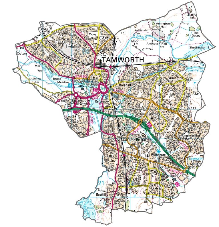
complement other proposals in the StrategyFigure 1
Tamworth Transport Strategy
F Development Sites
Residential Employment
(!
! ( !
( Broad Development in Lichfield District
Bus Service Extensions
Number 5 Number 6
Cycle Routes
Existing Proposed
Junction Improvements
!
( A5 Stonydelph
k
j "
) !
( Glascote Road / Marlborough Way
!
( A513 / Coton Lane / Gillway
!
( A5 Mile Oak
!
( Meadow Road / Ventura Park Road
Amington
!
( !
( Coton Lane / Fontenaye Road
k
j !
( Coton Lane / Claremont Road
!
(
k
j Other Improvements
k
j Salters Lane Pedestrian Improvements
k
j Access Improvements to Drayton Manor Park
Mile !
( k
j Potential Pilot Traffic Management Scheme
Oak Bonehill
k
j Potential Additional Car Park Exit
Belgrave
"
) Tamworth Rail Station Improvements
including Parking Capacity
Fazeley
Potential Site Access
Aldergate - Upper Gungate UTC
Drayton Manor "
)
Wilnecote Proposed Carriageway Widening
Wilnecote Stonydelph
Theme Park
Rail Station
(!
! ( Improved Sustainable Travel Links
(!
k
j Potential Walk / Cycle Bridge
Dosthill !
(
Not to Scale
!
(!(!
( Potential Walk / Cycle Routes
This product includes mapping data licensed from Ordnance Survey with the permission of the Controller of Her Majesty's
Stationery Office © Crown copyright and / or database right 2015. All rights reserved. Licence Number 100019422. Bus Access Improvements ( including RTPI )For more information please contact: Connectivity Strategy Transport and the Connected County Staffordshire County Council No. 1 Staffordshire Place Stafford ST16 2LP Tel: 0300 111 8000 Email: transport.planning@staffordshire.gov.uk If you would like this document in another language or format (e.g. large text), please contact us on 0300 111 8000 or email transport.planning@staffordshire.gov.uk
You can also read