2021 Atlantic Hurricane Forecast - Inside This Outlook 2020 Tropical Review 2021 Hurricane Forecast & - Andover, CT
←
→
Page content transcription
If your browser does not render page correctly, please read the page content below
2021 Atlantic Hurricane
       Forecast

               Inside This Outlook
                 2020 Tropical Review      2

               2021 Hurricane Forecast &
                                           2
                 Landfall Probabilities

                 The Oceans & La Niña      3

                 Historical Analogs &
                                           4
                  Forecast Guidance
2021 Atlantic Hurricane Forecast
2020 Tropical Season Review
The 2020 Atlantic Hurricane Season gusty winds to parts of the Mid-At-
featured a record 30 named storms, lantic into New York. Then, Isaias hit
14 hurricanes, and a record tying 7 North Carolina as a hurricane before
major hurricanes. 11 storms made racing up the East Coast, bringing
landfall in the United States, breaking widespread power outages, numer-
the previous record of 9 set in 1916. 10 ous tornadoes, and flooding rain
storms during the season underwent through New England. Power outag-
“rapid intensification” at some point, es were rather long lasting in parts
tying another record and keeping of New Jersey, New York and Con-
coastal residents on their toes. necticut, making Isaias the costli-
est hurricane in the Northeast since
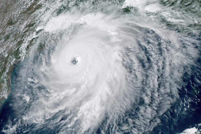
The U.S. Gulf Coast was extremely Radar image of Hurricane Laura making Sandy in 2012.
hard hit. 5 storms made landfall as landfall in Louisiana. Via NOAA.
hurricanes along the Gulf Coast, The season was prolonged, and con-
with Louisiana especially impacted, Louisiana since 1856. Hurricane Hanna tinued into November, with back-to-
seeing 3 hurricane landfalls (Laura, also made landfall in southern Texas, back major hurricanes (Eta and Iota)
Delta, and Zeta). While not as costly while Hurricane Sally struck Alabama. striking Nicaragua only 13 days and
or deadly as Katrina, Laura struck 15 miles apart. This resulted in hun-
the coast with winds of 150 mph, the In the Northeast, Tropical Storm Fay dreds of fatalities and billions of dol-
strongest winds in a hurricane to hit brought areas of flooding rain and lars in damage from the two storms.
The 2021 Outlook
A 2021 hurricane season with fewer storms than 2020 is a
near certainty. While some signals point to another active 2020 Tropical Cyclone Breakdown
season, they are more mixed than last year. We’re leaning
towards a more active than normal season, which would Named Major
Period Hurricane
be the sixth in a row if it verifies. Note that the “average” Storms Hurricanes
numbers for named storms and hurricanes are a bit higher Thru July 2-4 0-1 0
for this season, reflecting the new 30 year averages from
1991 - 2020. Regardless, we expect a few storms in June Aug - Sept 6-9 3-6 1-2
and July, though most of these will tend to be weaker. A
Oct - Nov 3-5 2-3 0-1
fairly sharp peak in activity is favored later in August into
September. Many recent seasons have been slow to end, Total 13 - 17 6 - 10 2-3
with notable activity into at least October, and we expect (Hist. Avg) (14) (7) (3)
a similar trend this year.
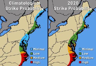
2021 Strike Probability Compared to Climatology
With a lean towards another active season and a pattern
that may steer storms towards the Mid-Atlantic at times,
the risk for a tropical impact is a category higher than nor-
mal from New Jersey and points south. This situation will
be more likely during the first half of the season (through
August). Further north, the risk of an impact is near normal
for New England and Long Island. In September and early
October, the threat area may shift towards the Southeast
and Gulf Coast. As we saw with Isaias last year, even one
direct hit can be quite damaging, and indirect impacts can
still result in heavy rain and rough surf from storms pass-
ing hundreds of miles away.
Page 2 www.weatherworksinc.com
2021 Atlantic Hurricane Forecast
The Oceans and La Niña
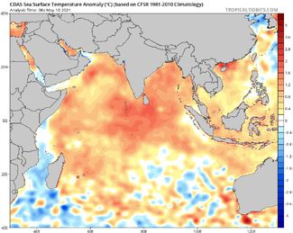
La Niña Weakening Looking East into the Indian Ocean
La Niña conditions, or cooler than usual waters across For the second year
the Tropical Pacific, were in place for the 2020 hur- in a row, the Indi-
ricane season and contributed to the record activity an Ocean is much
across the Atlantic. The La Niña event has weakened warmer than nor-
quite a bit this spring, with neutral conditions favored mal, and is most ex-
for much of the summer. This isn’t a strong indicator for pansive across the
above or below normal activity. Also, more spread de- western part of the
velops in the guidance after August; whether we break basin. This anomaly
towards El Niño, or back to La Niña, may tell if the sea- does two things: 1.)
son ends up closer to normal or turns active once again. A warm Indian Ocean
can stave off El Niño
Indian Ocean water temperature
development. El Niño
anomalies. Tropical Tidbits.
events (the opposite
of La Niña) can limit Atlantic Ocean tropical develop-
ment. 2.) The warmer Indian Ocean can provide added
fuel to tropical waves that move west across Africa.
These can become seeds for tropical development
when they enter into the Atlantic. The set-up may help
fuel a few longer-track hurricanes towards the peak of
the season in August and September. As a result, these
Indian Ocean waters are a potential signal for another
busy season.
El Niño model projections, courtesy of ECMWF.
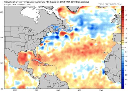
Pent-Up Atlantic Ocean Warmth
It’s a rather straight-forward meteorological concept:
warmer waters can fuel hurricane development. So,
seeing lots of “red” (above normal water temperatures)
on the Atlantic sea surface temperature map raises
concern for an active season. A potential saving grace
is the relatively cooler waters across the tropics, which
may try to keep a lid on some longer tracked, deep tropi-
cal hurricanes. However, it’s not a promise these cooler
waters last into the summer. Otherwise, the warmth in
the subtropics (closer to the US) may favor more activ-
ity than normal, and the overall warmth of the Atlantic Atlantic Ocean water temperature anomalies.
basin is enough to raise concern for increased activity. Courtesy of Tropical Tidbits.
Storm Names for 2021
• Ana • Elsa • Ida • Mindy • Rose • Wanda
• Bill • Fred • Julian • Nicholas • Sam
• Claudette • Grace • Kate • Odette • Teresa
• Danny • Henri • Larry • Peter • Victor
Page 3 www.weatherworksinc.com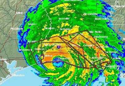
2021 Atlantic Hurricane Forecast
Historical Analogs & Forecast Guidance
A Look into the Past
Because computer model fore- Last year’s analogs strongly
casts become less accurate pointed to an active season; our
the farther out in time we look, analogs this year are a little more
we often augment the guidance mixed. As a result, they aver-
by analyzing the past for long age out to a near normal season,
range predictions. To do this, we with tropical activity peaking in
find past years with similar cur- August and September, but con-
rent and expected conditions tinuing into October. However,
to this year. Then, we see how out of the four analog years from
many storms occurred in these the last decade, three of them did
similar seasons, and where they end up rather active, which sug-
tracked. For 2021, we looked for gests we may be in a cycle where
Tropical cyclone frequency for
years with a weakening La Niña these conditions yield increased
analogous years.
in the Pacific, a warm Indian activity. Overall, the analogs sup-
Ocean, a fairly warm Atlantic, along with other condi- port the idea of less activity than last season, but still
tions such as upper atmospheric wind patterns. potentially finishing above normal.
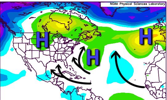
Favored Storm Tracks
The plot to the right shows surface pressure anomalies
from some of our top analog years. Blues reveal lower pres-
sure than normal and the potential for increased tropical
activity, where yellows indicate high pressure and reduced
storminess. 2020’s analogs strongly (and correctly) favored
Caribbean and Gulf Coast hurricanes, this year’s analogs
are more variable. A decent signal exists for storms curv-
ing well out to sea over the open Atlantic. There is also a
“soft spot” from the Caribbean and Gulf of Mexico to near
the East Coast, leaving the door open for some activity.
It’s possible that storms curve near or just off of the East
Coast during the first half of the season, then shift towards
the Caribbean and Gulf of Mexico towards Sept. and Oct. Surface pressure anomalies from analog years. ESRL.
Forecast Guidance
Some computer guidance does run several months into
the future and may provide clues for a seasonal fore-
cast. However, we give these models less weight in
the overall forecast due to reliability concerns at this
range. Nevertheless, guidance for this season does jive
with the analog and water temperature considerations
discussed previously. There are some signals for an ac-
tive tropical wave train coming off of Africa (note the
greens), along with increased activity over the open
Atlantic, especially a little farther north. There are also
some signs for activity in the Gulf of Mexico and near
or just off of the East Coast. Time will tell if the models
Peak season rainfall anomalies from the CFS model are onto something with a dry Caribbean, suggesting
(greens = wetter than normal). Tropical Tidbits. reduced activity there.
Page 4 www.weatherworksinc.com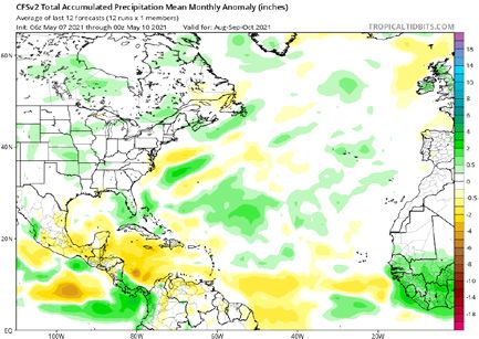

You can also read