9 SUMMARY, FINDINGS, AND DISCUSSION - Boston Region MPO
←
→
Page content transcription
If your browser does not render page correctly, please read the page content below
9 SUMMARY, FINDINGS, AND DISCUSSION

9.1    CORRIDOR SOCIOECONOMIC PROFILE, LAND USE, AND ZONING

The study corridor’s high population and employment densities, when they are supported by the
right land use, zoning, and transportation infrastructure, can form an excellent basis for smart
growth, transit-oriented development, and urban rejuvenation.

Existing population density is very high in Somerville, where approximately 75,000 residents
live in an area of four square miles, and also high along Route 28’s middle section. Population
density along the study corridor is lowest in the northern segment, from the Mystic River Bridge
to Mystic Avenue; it is 1,200 people per square mile in the Mystic View neighborhood. In the
middle section, between Mystic Avenue and Medford Street, it ranges from 1,200 to 12,000
people per square mile. Along its lower segment, from Medford Street to Museum Way,
population density in East Cambridge is about 6,500 people per square mile. The densest areas of
residential population contain multifamily residential buildings, including high-rise apartments.

Employment density along the study corridor exhibits a different pattern from that of population
density. The middle segment of the corridor has low employment densities, while the northern
and southern segments contain areas with high employment densities, around 2,100 employees
per square mile at Assembly Square and between 1,250 and 9,700 in Somerville and East
Cambridge areas along the southern segment.

Land use along the northern segment is light-to-medium-density residential (Mystic View),
industrial (Assembly Square), and urban open (public and institutional open space, vacant
undeveloped land along Mystic River at Assembly Square). The middle segment is characterized
by multi-unit residential, commercial, and recreational (Foss Park) land use. Land use along the
southern segment includes residential and commercial, but is mostly industrial and
transportation.

Zoning along the northern segment of the study corridor is single-family residential, commercial,
industrial, mixed use, and conservation. This type of zoning is intended to preserve the single-
family residential character of Mystic View, allow for mixed use, smart-growth types of
development in Assembly Square, and conserve open space for recreational uses. The zoning for
the middle segment is consistent with present uses, residential and commercial. Finally, zoning
along the southern segment includes residential and commercial, but is primarily industrial and
mixed use along the northern side of the roadway (North Point, Inner Belt, and Brickbottom, the
latter being the area bordered by Washington Street, Route 28, and Somerville Avenue).

CTPS                                                                                           57
Toward a Route 28 Corridor Transportation Plan: An Emerging Vision

9.2       ROADWAY CHARACTERISTICS

Route 28 is heavily used and is a very important roadway not only to Somerville but also
regionally, as it provides for mobility between origins and destinations beyond it and land access
along it. Consistently with the character of the service it is intended to provide, it is classified as
“Other Freeway,” a higher level of principal arterial.

The results from this study’s morning peak period license plate survey shed light on Route 28’s
function in the southbound direction:

      ●   Commuters from cities and towns with direct access onto Route 28 use the roadway to
          access points along it, East Cambridge, Cambridge, and points in Boston.

      ●   Commuters from north of Somerville who take I-93 for the major portion of their trip use
          Route 28 as a collector to reach the same types of destinations as those just listed for
          commuters from cities and towns with direct access onto Route 28.

      ●   On a typical commuter morning, the roadway is used far less as a through facility to
          Boston than as a collector/distributor facility between origin and destination towns that
          are not served well by I-93 more directly. Less than 11 percent of the Route 28 traffic
          observed just west of Broadway was also observed at the Museum of Science.

The survey results are for a typical weekday morning. However, when there is an emergency on
I-93 or the CA/T, Route 28 serves as the alternative to I-93 for points in downtown Boston and
south of it. This function is also consistent with its designation and intended use, as contingency
planning dictates that reroutings to lower-level facilities are necessary in emergency situations.

Route 28’s Traffic Pattern: A Collector-Distributor Road

Consistently with the results of the origin/destination survey, the roadway’s general traffic flow
pattern is one where its weekday traffic rises from north to south, with the highest point in the
vicinity of Washington Street.

The roadway collects traffic from major crossing roads beginning with Route 16, just north of
the Mystic River Bridge, and then from I-93, Route 38, Broadway, Pearl Street, and Medford
Street. After Medford Street, the roadway’s traffic begins to drop as drivers seek destinations
served by Washington Street, Somerville Avenue, Third Street, and Land Boulevard. Towards
the end of the study area, Cambridge Street’s and Charlestown Avenue’s traffic contributions are
significant, and Route 28 traffic rises again, but at lower levels than those in the midsection.

For comparison, at its highest traffic point, between Medford Street and Washington Street,
Route 28 carries as much traffic as Route 3A’s Neponset River Bridge south of Gallivan
Boulevard or the Leverett Connector south of the Route 1 off-ramp. At its midrange traffic point,
it carries about as much traffic as Route 9 in Newton just east of I-95/Route 128, New
Rutherford Avenue north of Austin Street, or Route 1A at the Boston/Revere city line. Some of
these roads do not intersect with roadways as high in traffic volumes as some roadways that

58                                                                                  Boston Region MPO
Toward a Route 28 Corridor Transportation Plan: An Emerging Vision Route 28 intersects, and some have grade-separated connections to other roads. Route 28’s lowest traffic volume, which is in the southern segment, is comparable to the volume on Massachusetts Avenue in the vicinity of Commonwealth Avenue. The traffic volume pattern and intensity of the roadway would of course be important factors in determining the feasibility of reconstructing it as a boulevard that intersects Washington Street at grade. In order to bring about significant traffic volume reductions, a variety of measures would be required that could include improved public transportation, improved incident management on I- 93, a direct I-93 connection to Brickbottom and East Cambridge, and policies promoting trip reduction, growth management, and parking limitation. Some of these ideas are already under study in the form of the Urban Ring, the Green Line extension, and the Orange Line station at Assembly Square. Roadway Traffic Conditions: Present and Future Major nodes of traffic exchange along Route 28 are at Wellington Circle (Route 16), Mystic Avenue (Route 38), Broadway, Pearl Street, Medford Street, Washington Street and Somerville Avenue ramps, Third Street, First Street, Cambridge Street, and Land Boulevard, all high- volume crossing roads with average weekday traffic in the high to low 30,000s. Delays and queues are common at most of these locations, especially during peak hours and midday Saturday, with operations at level of service C or worse. Because of these delays at the intersections, peak period speeds in the corridor are below the 35 mph speed limit. In the off- peak hours, speeds often exceed the limit, raising resident concerns, especially in the mid- McGrath section. Route 28 at I-93 and Mystic Avenue is the highest-crash location along the roadway (it is among the highest in the Boston region), followed by the intersections at Washington Street and at Broadway. Bicycle and pedestrian crashes are also at the corridor’s highest levels at these three locations. The intersections at Medford Street, Pearl Street, and Broadway were recently improved. Improvements included new or repaired pedestrian traffic signals with appropriate phases and phase durations. Additional intersections have been improved or soon will be as part of development mitigation (details on mitigation improvements can be reviewed in Appendix B). In the future, without significant traffic reduction measures, congestion is expected to grow progressively worse along Route 28. In most cases, level-of-service calculations from area development studies show development impacts to be mitigated by their proposed improvements. However, intersections that are currently problematic continue to have poor operations under future conditions even assuming implementation of the proposed mitigation strategies. CTPS 59
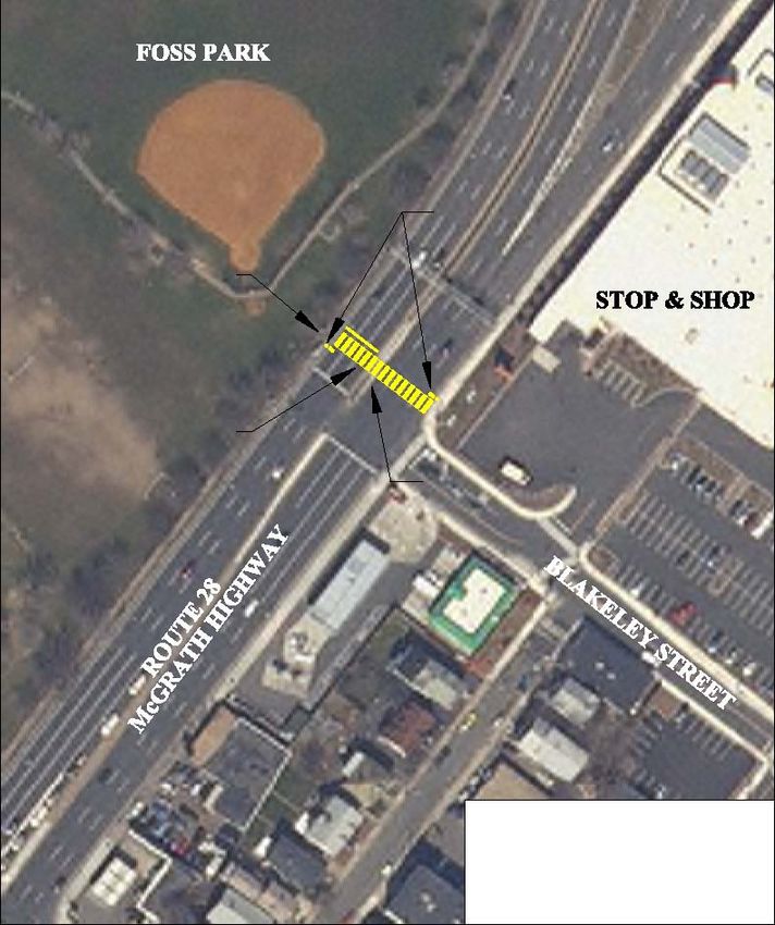
Toward a Route 28 Corridor Transportation Plan: An Emerging Vision

9.3      PUBLIC SAFETY AND URBAN DESIGN OPPORTUNITIES

Safety for drivers, pedestrians, and bicyclists is of great concern to task force members and
citizens. The focus of their concerns is certain accident-prone locations along Route 28.

Route 28 at Mystic Avenue (Route 38)/I-93 Ramps

This is a rather broad geographic area to which safety monitoring has attributed high levels of
crashes over the years. The area, sometimes referred to as the “area of Route 28 and Route 38
under I-93,” consists of several locations where conflicts between vehicles, pedestrians, and
bicycles may arise, including:

•     The signalized intersection of Route 28 northbound at Mystic Avenue
•     The signalized intersection of Route 28 southbound at Mystic Avenue
•     All I-93 ramp termini at either I-93, Route 28, or Route 38

Most recently, this location ranked 66th in the top 200 arterial crash locations statewide. Almost
half of the crashes are of the angle type involving conflicts with left-turning and
merging/diverging vehicles at the I-93 ramps.

In the past, MassHighway, its consultants, and the City of Somerville have studied this location
to improve vehicle and pedestrian mobility to the neighborhoods, Foss Park, Assembly Square,
Mystic Avenue, and I-93. The current Transportation Improvement Program has $432,130
programmed in the years 2007 through 2009 for the study and design of the interchange. Also,
the Regional Transportation Plan has provided $58,500,500, scheduled for the years 2021 to
2030, for construction.

In addition to safety improvements, important contributions of ongoing study should be
neighborhood accessibility, circulation, and connections across I-93 and Mystic Avenue. As part
of the study, it is critical in terms of urban design and neighborhood preservation to explore how
the roadway system and the highway’s ramp system in this area may be reconfigured to improve
connections for drivers, pedestrians, and bicyclists between Assembly Square and the residential
neighborhood at the southeast quadrangle of the I-93/Route 28 interchange, bounded by
Broadway, Route 28, and the Mystic Avenue eastbound/I-93 ramps. To this end, several schemes
were proposed in the original Assembly Square Transportation Plan Final Report (2003) and
most recently in the Planned Development Unit – Assembly Square, Preliminary Master Plan
filed with the City of Somerville in October 2006.

Route 28 at Foss Park

Since the opening of the Stop and Shop supermarket across from Foss Park, there has been a
pedestrian accessibility issue for residents using the park or that live north of Route 28. Advisory
Committee members reported that people have been climbing over the fence at Foss Park and
crossing Route 28 to the Stop and Shop without proper signal control. This is creating a highly
unsafe situation at this location.

60                                                                               Boston Region MPO
Toward a Route 28 Corridor Transportation Plan: An Emerging Vision

Constructing a pedestrian crossing at the existing Blakeley Street intersection that was
constructed as part of the Stop and Shop mitigation would help alleviate the unsafe situation and
improve access across Route 28. This crossing would alleviate the lack of access to Foss Park
and provide an additional crossing of Route 28 for area residents. Figure 9.1 provides a
conceptual design of the proposed pedestrian crossing.

Route 28 at Broadway, at Pearl Street, and at Medford Street

These three locations were improved recently in their operations and safety. The intersection at
Broadway ranked 114th in the state in crashes for MassHighway’s monitoring period, 2002 to
2005. 1 The majority of the crashes at these locations are the rear-end type, which is an indication
of stop-and-go traffic and congested conditions.

Improvements addressed operational, especially safety, problems related to the condition of the
equipment and operation of the pedestrian phases for safe crossing of Route 28, Broadway, Pearl
Street, and Medford Street. Past complaints have included “insufficient pedestrian phases to
cross Route 28” and “lack of exclusive pedestrian phases.”

The reconstructed intersections and new signal equipment have corrected those deficiencies. At
Broadway for example, there are concurrent pedestrian phases with long enough “walk/flashing
don’t walk” times to allow pedestrians to fully cross either Broadway or Route 28 without
getting caught halfway. The Pearl Street intersection has an exclusive pedestrian phase. Both
intersections’ signals are pedestrian actuated.

Route 28 at Washington Street

The majority of the crashes at this location are of the angle type, indicative of heavy left turns
and merging/diverging activity at the Washington Street ramps.

One safety-related issue of concern for the City of Somerville at this location is the structural
condition of the viaduct over Washington Street, which is part of the elevated Route 28 structure,
built in 1925. A 2008 bridge condition assessment by the Department of Conservation and
Recreation designated its overall condition “fair” with a rating of “5” which indicates that repair
or reconstruction is not required immediately. Some members of the Advisory Committee
believe this assessment underestimates the deterioration of the viaduct.

The thinking of some members of the Advisory Committee, the City, and many citizens is that
when the viaduct deteriorates to the point that it needs reconstruction, it should be demolished
and the roadway reconstructed at grade instead. This thinking is in line with the City’s urban
design vision for the corridor and the conversion of the midsection of the study area highway
into a boulevard. Citizens and the City are concerned that the elevated structure deters access,
obstructs visibility and economic development, and is an obstacle to neighborhood integration,
and that the ramp termini are dangerous for pedestrians.

1
    Ibid.

CTPS                                                                                                  61
PROPOSED PEDESTRIAN
BUTTON & SIGNAL HEAD
PROPOSED ACCESS
TO FOSS PARK
PROPOSED PEDESTRIAN
CROSSING
PROPOSED
BREAK IN MEDIAN
Notes
1. Maintain use of existing traffic control
signals and operations.
2. Relocate Route 28 southbound stop
line to proposed location.
3. Construct wheelchair ramps at either
side of proposed pedestrian crossing.
FIGURE 9.1 Toward a Route 28 Corridor
Proposed Foss Park Transportation Plan:
CTPS Pedestrian Crossing An Emerging VisionToward a Route 28 Corridor Transportation Plan: An Emerging Vision If the option of removing the viaduct section is pursued, the planning process for the project would need to explore in detail many related issues of access, traffic, design, and land use. The main focus would be to identify additional access points to Union Square, East Cambridge, and the rest of Cambridge in the context of future development of the Inner Belt, Lower Brickbottom, and Union Square and also in the context of the extension of the Green Line to Union Square and Medford Hillside. With multiple access connections to these destinations via roadways, public transportation, and bicycle/pedestrian paths, Route 28 would cease to be the sole collector/distributor road for people wishing to reach these cultural and economic development neighborhoods in Cambridge and Somerville, and its traffic volumes would be lower. 9.4 PLANNED PUBLIC TRANSPORTATION INFRASTRUCTURE The major public transit services for corridor residents are the Orange Line, the Green Line, and all MBTA buses to Lechmere, Sullivan Square, and Wellington Station. MBTA commuter rail lines run through the area, but there is no station near the Route 28 corridor. Significant for the corridor’s future economic development occurring in a transit-oriented fashion are three proposed public transit capital improvements, currently at different planning stages: • Urban Ring • New Orange Line station at Assembly Square • Green Line extension to Medford Hillside/Union Square The Urban Ring is a circumferential system of transit improvements to provide direct connections between many of the MBTA’s existing radial transit lines. Residents in Boston, Chelsea, Everett, Medford, Somerville, Cambridge, and Brookline stand to benefit from this service. The Urban Ring is proposed for implementation in three phases: Phase 1 improves bus service in the Urban Ring corridor; Phase 2 would consist of bus rapid transit service in the corridor; Phase 3 would add rail rapid transit in portions of the corridor. Elements of the Urban Ring would be integrated with the Green Line extension west of Lechmere. The Green Line extension would connect Lechmere Station to Medford Hillside (with a spur to Union Square), partly via an existing rail freight line and partly beside the Lowell commuter rail line. The distance from Lechmere to Medford Hillside is 4.2 miles, and approximately six new stations in Somerville and Medford would be built. The project includes the relocated Lechmere Station on the northern side of the O’Brien Highway, across from its existing location. The new Orange Line station project would add a station on the existing Orange Line at Assembly Square, between Sullivan Station in Charlestown and Wellington Station in Medford. The station would likely be used mostly for travel to and from the planned development at Assembly Square. Recent approval of the Assembly Square Master Plan will help determine the land uses of the development there, making ridership projections easier. The station is presently CTPS 63
Toward a Route 28 Corridor Transportation Plan: An Emerging Vision

listed in the Transportation Improvement Program for construction in 2010, and $31,250,000
will be appropriated for that purpose.

These potential transit improvements are expected to have a catalytic effect towards sustainable
development and enhanced urban design in the corridor, including reduced vehicle trips,
improved air quality, improved accessibility, and a safer Route 28.

9.5      LOWER ROUTE 28 SEGMENT: LAND ACCESS AND VISIBILIY

In contrast to Assembly Square, where development and urban design plans are already
underway, the lower segment of the corridor abuts many evolving industrial areas with great
development potential but largely unformed plans. The referenced area is located south of
Washington Street, east of Route 28, and in between the MBTA’s Lowell and Fitchburg
commuter rail lines and associated rail yards.

The attractiveness of this area, which is in excess of 90 acres, stems from:

●     Proximity to I-93 and Route 28
●     Urban Ring project
●     Proximity to the Orange and Green lines, and two commuter rail lines
●     Proximity to financial and educational institutions in Boston, Cambridge, and Somerville
●     “Gateway” potential to “cultural pockets” in Somerville and Cambridge (Union Square,
      Davis Square, Teele Square, Kendall Square, and Harvard Square)
●     Proximity to recreational destinations at the Charles River Basin and the Mystic and Malden
      rivers

However, despite its potential and high interest from the City of Somerville, there are no
definitive plans at present (except for the current phase of the North Point project, which is in the
early stages of construction) to develop this area, because it is, essentially, “landlocked” between
Route 28, Washington Street, active rail lines, and rail yards, with limited visibility and access
from these facilities and no access points across them. Potential access/egress opportunities
include connections to I-93, Rutherford Avenue bypass, Route 28, Union Square, East
Cambridge, North Point, the Green Line extension, and bicycle and pedestrian paths. Addressing
the accessibility challenges for this part of Route 28 is fundamental for the future development of
the entire corridor, including the potential incorporation of urban design and neighborhood-
integration elements into it, and for the improvement of the air quality and of the quality of life
of people who live along it.

9.6      BICYCLE AND PEDESTRIAN PATHS, AND OPEN SPACE

The ability to walk or bicycle throughout the metropolitan region is achieved through the sharing
of facilities with autos. The street system is the primary component of the bicycle network, and the
requirement that bicycles and cars successfully share the non-expressway road system is
fundamental to bicycle use regardless of the expansion of the recreational trail system.

64                                                                                Boston Region MPO
Toward a Route 28 Corridor Transportation Plan: An Emerging Vision Much as the auto network has been augmented with limited-access expressways, the pedestrian and bicycle transportation systems are being augmented by expanding subsystems of multi-use, off- road trails (usually referred to as “bike” trails), pedestrian-only paths, and designated on-road bike routes. Most of the existing trails in the Route 28 vicinity are in the waterfront area, and some are fragmentary. The proposed trails would provide some connection to the existing trails and make some of the open space more accessible. Also, the Community Path Phase 1 is programmed in the Transportation Improvement Program. However, continued work needs to be completed to ensure that bicycle safety and access are improved throughout the corridor and neighborhoods. 9.7 PUBLIC PARTICIPATION Public participation is essential to good planning and is required by federal, state, and local project- review laws. The underlying premise of public participation is that, because residents are stakeholders and may be impacted by public and private projects in their community, their concerns and comments need to be heard and addressed. Route 28 corridor citizens are very active in the public participation process. Some of the most well-known public advocacy groups are the Mystic View Task Force (MVTF), the Somerville Transportation Equity Partners (STEP), and the East Cambridge Planning Team. The geographic focus areas of these groups are different, but they hold goals in common: to advocate transit-based development, promote good urban design, maintain and increase open space, and achieve equitable transportation in order to protect the environment and the community. MVTF is best known for its advocacy efforts since 1998 to develop Assembly Square as a transit- oriented development: a mixed-use, high-density development around a new Orange Line station, with easy access to open space at the banks of the Mystic River. The group employed various participation tools to enforce existing zoning and environmental legislation, including lawsuits against Assembly Square developers and the City of Somerville. The 2006 approval of an Assembly Square Master Plan and the securing of federal funds (with developer matches) to construct the new Orange Line station have rewarded their efforts. STEP is largely concerned with air quality and transportation equity in East Somerville. STEP claims that transportation is inequitable in East Somerville, where population—immigrant population in particular—is high, a large segment of the population does not own cars, several MBTA rail lines cross the area but do not have stations, and cancer and respiratory incidents are higher than the state average. The organization’s website contains useful articles to educate people on these issues, and STEP has also advocated for studies to measure air quality levels in East Somerville. In Charlestown, an active public participation process led to the successful completion of the Rutherford Avenue Corridor Transportation Study, which developed various alternatives for land use and roadway alignment. CTPS 65
Toward a Route 28 Corridor Transportation Plan: An Emerging Vision

The East Cambridge Planning Team was very important in the process of developing the East
Cambridge Planning Study (ECAPS). The study recommends a set of zoning actions that aim to
fulfill a vision of the future of eastern Cambridge, which includes the areas of East Cambridge,
Wellington-Harrington, Area IV, and MIT.

These and other groups have a significant role to play in the creation and implementation of an
urban design/transportation vision for the Route 28 corridor. Participation needs to begin during
the planning stages and at various levels, including the city level—Boston/Charlestown,
Cambridge, and Somerville—and the subregional/tri-city level for coordination among the three
communities. For example, the redesign of Rutherford Avenue and the bypass road in
Charlestown, accessibility for Brickbottom and Inner Belt, and access across Route 28 to East
Cambridge are all related issues, and they must be discussed and understood together by the three
affected communities.

9.8     ENVISIONING A ROUTE 28 CORRIDOR PROCESS DESIGN:
        “THE BIG PICTURE”

The corridor is very attractive for economic development and presents a unique opportunity to
transform the existing postindustrial landscape into a visual and functional continuum of urban
space with human scale. In addition to the diverse ethnic and economic background of the
corridor’s and surrounding area’s population, the presence of the outstanding educational
institutions in Boston, Cambridge, and Somerville, the excellent access/egress opportunities
between Route 28 and I-93, and Somerville’s proximity to Boston’s economic basis are all
strong supporting factors for such a transformation.

The present zoning in Somerville and East Cambridge is designed towards a vision that promotes
the integration of land use with transportation and urban design, while respecting and integrating
neighborhoods. Examples of City and State efforts in that direction include the planned unit
development at Assembly Square, the studies of the Green Line extension and the Orange Line
station at Assembly Square, the planned studies of the I-93/Route 28 interchange and the Urban
Ring, the redesign/redevelopment of Union Square, and the plans for the Community Path and
access to recreational areas along the Mystic, Malden, and Charles rivers.

Most of these initiatives are in their initial stages; much more remains to be done in terms of
creative financing, legal commitments, growth management policies, design standards, and
project phasing so that these and other initiatives reinforce each other, and an optimum set of
development types and sizes, sustainable by the transportation infrastructure envisioned, is
arrived at.

In the corridor-wide design context, the redevelopment of the largest part of the developable land
in Somerville, Brickbottom, and Inner Belt is still an open topic. Major issues to be addressed
there include remediation of environmental contamination, restoration of the natural hydrology
of the sites, accessibility from/to and across I-93 and Route 28, connections to the extension of
the Green Line, bicycle and pedestrian paths, and the preservation and integration of
neighborhoods.

66                                                                              Boston Region MPO
Toward a Route 28 Corridor Transportation Plan: An Emerging Vision The renewal of the Route 28 corridor, like many such renewal processes, will likely be an ongoing and complex process with many actors, whose goals, strategies, financing potential, and political direction may change frequently. It is natural for this to create public uncertainty related to knowledge and values, intentions and strategies, and the decision-making process. To assist with this uncertainty, the City of Somerville’s leadership in open communication, including knowledge-sharing, with the public is very important. This will help people understand how the various individual and localized changes, including development mitigation, fit into the big picture, so that they can participate in the renewal process most effectively. CTPS 67
You can also read