SH6 MIDDLE RENWICK ROAD - CYCLE LANES PROJECT - Summary of Feedback
←
→
Page content transcription
If your browser does not render page correctly, please read the page content below
SH6 MIDDLE RENWICK ROAD
– CYCLE LANES PROJECT
Summary of Feedback
WAKA KOTAHI NZ TRANSPORT AGENCY
MARLBOROUGH DISTRICT COUNCIL
MARCH 2021
1. Background
Between 16 November and 14 December 2020, the Marlborough District Council (in conjunction with Waka
Kotahi NZ Transport Agency) sought feedback from the local community on the proposed cycle lanes for
Middle Renwick Road / State Highway 6 (SH6) in the Marlborough region.
The proposal was to extend cycle lanes along Middle Renwick Road between Blenheim’s Westwood
Business Park and Murphys Road/Battys Road and is part of a ‘big picture’ to develop a safe, convenient
and connected cycle network around Blenheim. By doing so, we aim to help make cycling a viable and
enjoyable transport option for those commuting to and from work and school, to get around town, and for
leisure.
Surveys indicate there are about 100 cyclists using this stretch of road each day, including school students.
Between 2015 and 2019, there were 16 crashes on this section of road, with six involving cyclists. This
project fills an existing gap in the cycle network along Middle Renwick Road and we would expect demand to
grow over coming years with the combined college merger and further subdivisions in the
Westwood/Springlands area.
This project also aligns to the Marlborough Walking and Cycling Strategy (2019-29) and the Government
Policy Statement (GPS) on land transport 2018 and 2021 (coming into effect July 2021) which prioritises
better travel options in our towns and cities. GPS 2021 also includes Climate Change as a strategic priority,
highlighting the Government’s commitment to reducing greenhouse gas emissions in the transport system.
2. Consultation process
Prior to undertaking the formal consultation process, we completed numerous steps including, for example,
car park demand surveys and a technical assessment of the road. This identified the existing provision for
cyclists on the road were not safe and appropriate for the current road characteristics and roadside
environments along this corridor.
Between 16 November and 14 December 2020, the Marlborough District Council undertook a number of
activities to raise awareness of the project and the public feedback process. These included:
Two letter drops to residents and businesses along Middle Renwick Road, between Battys Road and
Westwood Ave, on 13 November and 7 December 2020.
Two drop-in information sessions at Pak’n Save (Westwood Business Park) on Tuesday 24
November (4.00 pm to 6.00 pm) and on Saturday 28 November (11.00 am to 1.00 pm).
Two emails to each nearby school asking to distribute information about the project and public
consultation on 19 November 2020 and 7 December 2020. This included Marlborough Boys’
College, Marlborough Girls’ College, Bohally Intermediate and Springlands School.
Posters and design information were left at Council offices reception and Blenheim Library for
viewing by the public.
Two Council media releases on 11 November 2020 and 30 November 2020.
Subsequently, newspaper articles about the public consultation were published in The Blenheim Sun
(18 November 2020), Marlborough Express (12 November 2020) and Marlborough Weekly
(17 November 2020).
Information was included in the Council newspaper column on 18 November and 9 December 2020
in The Blenheim Sun newspaper and on 10 December in the Marlborough Midweek newspaper.
Facebook posts featured on the Marlborough District Council page on 19 November and
7 December 2020, including a sponsored post on 7 December 2020.
Council Antenno posts on 19 November and 24 November 2020.
Information and an online feedback form was made available on a dedicated project page at
https://www.marlborough.govt.nz/recreation/cycling-and-walking/projects-and-strategies/middle-
renwick-road-sh6-cycle-lanes
Engagement provided us with feedback which helped us to decide if an extension to the cycle lanes was in
line with community wishes and if any improvements to the design were needed.
People were able to submit their views through the electronic form on the dedicated Council web page and
hard copy submission forms which were available from the Marlborough District Council Blenheim office,
Marlborough District libraries (Blenheim) and via email or by ringing 03 520 7400.3. Feedback Question
The consultation phase is used to seek any additional information from stakeholders or the public that would
help inform the decision about the proposed cycle lane extension.
During this feedback process we asked the public to submit their feedback to the following question “Do you
have any feedback on the Middle Renwick Road cycle lane project design?”
We considered all factors raised during the feedback process when making design decisions for the cycle
lanes project.
4. Summary and Response to Submissions
We received 55 submissions of feedback - 51 online, 2 in hard-copy feedback forms and 2 via email.
We appreciated the response from the community and thank all those who provided their feedback.
The main factors that were expressed in the feedback from the public are summarised in the table on the
following pages. Appendix. 1 (following this summary) outlines the key themes, along with the main factors
people raised in their feedback and our comments in response.
Key themes identified were:
Parking
changes
Cycle lane
route and Street trees
design
Feedback
themes
Overall Crossings,
sentiment for footpaths and
the proposal shared paths
Roundabouts
Wider cycle
and
network
driveways
5. Decision
The table below shows the recommendations Marlborough District Council and Waka Kotahi have adopted
based on the feedback received between 16 November and 14 December 2020.
Construction is expected to be begin early May 2021 and be completed by June 2021.
Stakeholders will be notified by letter and the public are being notified via media release on the Marlborough
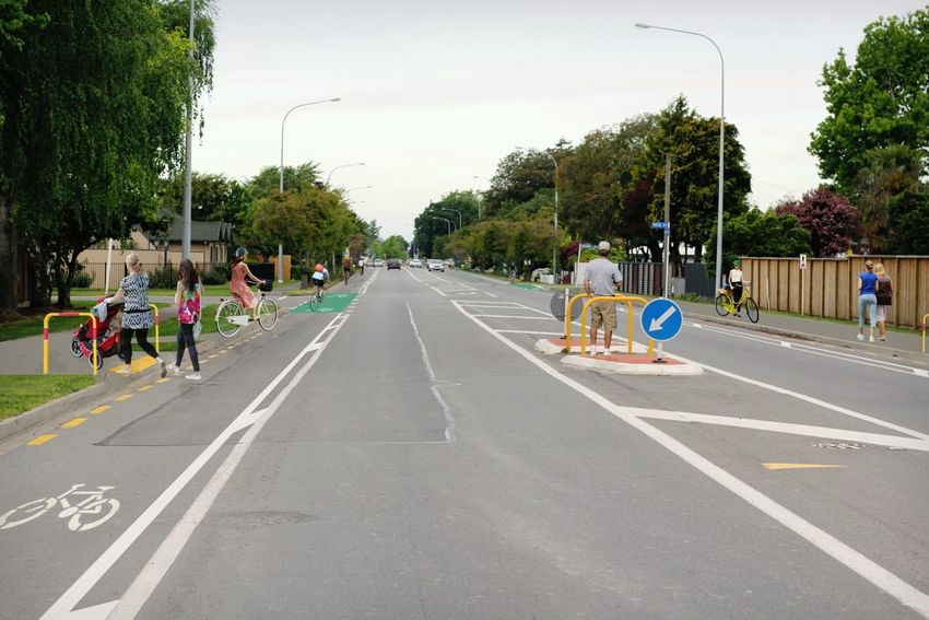
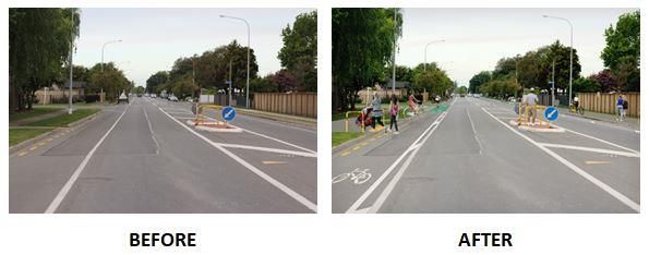
District Council website and social media ahead of the project getting underway.SH6/Middle Renwick Road Cycle Lanes On-road cycle lanes installed Lanes to be installed from Murphys Road/Battys Road through to Westwood Business Park, Blenheim 1.8 metre-wide cycle lanes Painted buffer between the cycle lane and traffic lane Parking Retention of 28 car parks, including retaining existing car parking near Murphys Road/Battys Road roundabout, and construction of four new indented parking bays between Battys Road/Murphys Road and Rose Street Removal of some car parking and the painting of yellow no-stopping lines Footpath Widening of the existing footpath to a shared pathway between Severne Street and Westwood Ave Murphys Road/Battys Road Roundabout Minor alterations to the entrance to the Murphys Road/Battys Road roundabout, to encourage cyclists to ‘take the lane’ when travelling through the roundabout Street Trees Removal of six street trees between Battys Road/Murphys Road and Rose Street to allow for indented car parking (offset by the planting of 150 other street trees annually) Map showing the cycle lane project location: To view the detailed design and aerial plans, visit the Marlborough District Council website: Menu > Recreation > Cycling and Walking > Projects and Strategies > Middle Renwick Road (SH6) Cycle Lanes Link: https://bit.ly/MRRCycleLanes
6. Submissions
A summary of the submissions received during the public consultation period is included in Appendix. 1 of
this document. The summary includes common themes that were submitted on, as well as illustrative quotes
to provide context, and response comments from Waka Kotahi NZ Transport Agency and Marlborough
District Council.
Appendix 1: Our responses to your feedback

Key themes          Illustrative Quotes                                       Comment from Waka Kotahi NZ Transport Agency/Marlborough District Council

General
General support     "Looks really good. Fully support this proposal."         The proposed cycle lanes provide a defined cycle route that is consistent with the
of proposal                                                                   existing cycle facilities along Middle Renwick Road (SH6).
                    "I consider the cycle lane proposal to be very
                    necessary for the future safety of cyclists, it would     The installation of cycle lanes is part of a wider vision to develop a connected network of
                    also be a great benefit to the environment and good       urban cycle facilities in Marlborough, as outlined in the Marlborough Walking and
                    health of the community."                                 Cycling Strategy (2019-29). Cycle lanes also align to the Government Policy Statement
                                                                              on land transport (GPS) both GPS 2018 and 2021 (coming into effect July 2021) which
                    "It looks great, definitely need more bike lanes in
                                                                              prioritises better travel options in our towns and cities. GPS 2021 also includes Climate
                    Blenheim."
                                                                              Change as a strategic priority, highlighting the Government’s commitment to reducing
                    "I think you should go ahead, as it can be very busy      greenhouse gas emissions in the transport system.
                    down that road, especially after school."
                                                                              The new cycle lanes will connect to the existing cycle lanes to the east between Boyce
                                                                              Street and Murphys Road/Battys Road, and the cycle bypass at the Westwood Ave
                                                                              roundabout, filling a gap in the network and improving connectivity for cyclists.

Safety concerns     "I often see cyclists being forced into the live lanes    Cycle lanes provide people on bikes with their own space on the road and reduces
about the current   due to cars being in the way and as a motorist it can     potential conflict with other road users (e.g. passing parked vehicles or vehicles entering
road layout         get a little hairy would be good to know all road         or exiting driveways).
                    users are being cared for with the surge in e-bikes
                                                                              Buffered cycle lanes comprise of a conventional on-road cycle lane with a painted buffer
                    and other bicycles."
                                                                              between the cycle lane and moving traffic lane and/or parking lane. The use of a buffer
                    "Fantastic idea, this is a very busy section of road in   makes it easier for drivers to pass cyclists at a safe distance, as well as increasing the
                    terms of car traffic and it would make it much safer      perception of safety by having something between the rider and the traffic lane.
                    for cyclists."
                                                                              People on bikes will still be required to 'take the lane' at the Battys Road/Murphys Road
                    "It can be very dangerous when you go wide around         roundabout. Speed differentials between bikes and vehicles were investigated at the
                    a car to make sure you don't get hit by a opening         concept stage and found to be at an acceptable level.
                    door, and then a car cuts very close while passing
                                                                              Road education campaigns and cycle skills training will continue, aimed at both drivers
                    you."
                                                                              and cyclists to improve the awareness of cyclists at intersections and roundabouts.
                    "I live close to the Westwood retail area and bike
                    there reasonably often. I regularly find it a hazardous
                    journey because the pathway for cyclists is unclear.
Key themes Illustrative Quotes Comment from Waka Kotahi NZ Transport Agency/Marlborough District Council
Opposed to "Absolutely unnecessary and a huge waste of Cycleways offer people alternative modes of transport for their commute, travelling to
proposal money!" schools, shops, or leisure activities. The proposed cycle lanes have been developed in
partnership between Waka Kotahi NZ Transport Agency and Marlborough District Council.
"Cycle paths are good, but there is NO need to make
them up to 2 metres plus a buffer zone."
The project aligns with the Marlborough Walking and Cycling Strategy (2019-29), and also
"I object to the proposed cycle lanes. If it turns out aligns to the Government Policy Statement on land transport (GPS) both GPS 2018 and
like Eltham Road it will be terrible." 2021 (coming into effect July 2021) prioritises better travel options in our towns and cities.
GPS 2021 also includes Climate Change as a strategic priority, highlighting the
"Plenty of room already for competent Cyclists and
Government’s commitment to reducing greenhouse gas emissions in the transport
Motorists."
system.
Design
Pak'nSave "I would like to see an access from Westwood Path access to Pak’nSave was initially raised in the concept design report. Due to budget
access avenue crossing over lawn into PAC and Save car constraints this connection has not been pursued as part of this project.
park."
Loss of trees "Hopefully each of the trees that has to come out will Care has been taken to maximise parking provision while minimising tree removal,
be replaced by others somewhere else, we have so however the indented car parking bays require the removal of six street trees.
few nice trees."
Street trees provide many benefits including beautification and traffic calming of the street.
Council plants 150 new street trees every year.
Z Petrol Station "At the Z petrol station what controls will there be on In relation to vehicles entering the Z Petrol Station, motor vehicles may drive within a
cars entering and exiting? This is a real worry." cycle lane to access a driveway if the driver gives way to cyclists using the cycle lane.
In relation to vehicles exiting the Z Petrol Station, like any other driveway, vehicles will be
required to give way to cyclists travelling along Middle Renwick Road (SH6).
This feedback has been incorporated into the design; green cycle paint will be painted in
the cycle lanes near the entry / exit points of the Z Petrol Station.
Cycle lanes - "I would like to suggest, however, that the buffer The painted hatched buffer will improve driver awareness of the cycle lanes, while also
audible cues lines incorporate some form of audible feedback for providing more separation between cyclists and passing vehicles than a traditional cycle
motorists if possible at key points (intersections, the lane.
start of lanes, and curves) such as rumble strip or
Audible devices such as rumble strips would not been suited to this environment given the
similar. My observations of motorist behaviour with
noise generation and likely impact on local residents’.
regard to other cycle lanes in Blenheim is that they
regularly stray/drift onto cycle lanes at these points
on roads, possibly without being aware that they are
doing this."Key themes Illustrative Quotes Comment from Waka Kotahi NZ Transport Agency/Marlborough District Council
Cycle lane "The width of the proposed cycleway would be 1.7m Cycle lane width is proposed to be 1.8m with a painted buffer between the traffic lane and
width plus a .4m buffer. However it is noted that in NZTA cycle lane. Where the cycle lane passes the indented parking bays, the buffer will be
guidelines for cycle lanes, the recommended width retained where possible.
for cycle lanes adjacent to parallel parked cars is
1.8m."
Shared "Shared pathways are always a problem." Shared pathways are for everyone to enjoy by foot and bike. Council promotes a shared
Pathway pathway etiquette that includes encouraging users to keep left, warn other path users on
approach, and move off the path when stopping.
Shared Pathway signage will be installed at the entry/exit points of the proposed shared
pathway.
Signage "I am all for the cycle lanes but there really needs to Waka Kotahi NZ Transport Agency and Council will continue various education
be some education (signage) on how the riders use programmes, including targeting people on bikes and other road users on how to use new
them." cycle infrastructure. This includes cycle skills training programmes targeting schools and
adult riders.
Footpath "… the tree roots have lifted up the concrete footpath This information has been passed onto Council Parks and Open Spaces and Marlborough
damage between our boundary and the tree making a real Roads to follow-up on.
hazard for people walking along the footpath
especially the elderly."
Parking
Loss of car "What concerns me is not having a car parking Weekday and weekend parking demand surveys in June and July 2020 have identified a
parking space on the roadside outside XXXXXXXXX for current parking demand of 16 car park spaces.
concerns when we have visitors as we only have a very small Twenty eight car parks would be retained, through retaining existing car parks between
section with very limited parking on the property." the Murphys Road/Battys Road roundabout and Adams Lane, as well as constructing new
"If this cycle lane goes ahead it will remove much indented car parks between the Murphys Road/Battys Road roundabout and Rose Street.
needed parking spaces outside our home/business. This comfortably exceeds the identified demand for parking by 40%.
We have a minimum of 3 cars requiring street Following feedback being received on trucks/heavy vehicles parking, the design for the
parking spaces week days." indented parking bays outside 169 and 174 Middle Renwick Road (SH6) will now be
"Trucks, cars with trailers etc frequently stay and constructed to 2.5 metres where possible to accommodate trucks and larger vehicles.
park directly outside. not enough room or because Two additional 2.0 metre wide indented parking bays, outside 163 and 157B Middle
of limited space we feel everyone (including the Renwick Road have been included in the detailed design. This will require the removal of
service station customers will park there.)" one additional street tree.
“The impact on our business will be huge. We hold
conferences which require parking on the street. We
have tour buses, trucks, boats and sports team with
large trailers, that park outside our motel. Also our
guests have visitors that visit that park on the street.”Key themes Illustrative Quotes Comment from Waka Kotahi NZ Transport Agency/Marlborough District Council
Sufficient "I rarely see cars parked on this piece of highway, as Weekday and weekend parking demand surveys in June and July 2020 have identified a
parking most motels, residences and other businesses have current parking demand of 16 car park spaces.
available sufficient off road parking."
Twenty eight car parks would be retained, through retaining existing car parks near the
Murphys Road/Battys Road roundabout, as well as constructing new indented car parks
between Battys Road and Rose Street. This comfortably exceeds the identified demand
for parking by 40%.
Indented “It’s good that there is offset, indented parking so Indented parking is included in the designs and intended to meet the current parking
parking that the bike paths are clear." demand along the route.
The painted buffer has been retained where it runs adjacent to indented parking where
possible. This buffer provides more room for cyclists particularly when passing parked
vehicles.
Indented "People pulling straight out in front of cycles from the Cycle lanes will be on both sides of the road and run adjacent to the indented car parks.
parking indented car parks ( as they are not use to cycle lane With the cycle lane positioned between the general traffic lane and the parking bay,
concerns being on the wrong side." drivers pulling out of the parking bay will need to look, signal and giveway to all road users
(including cyclists) before pulling out into the live traffic lane.
"Wide vehicles will still encroach on to the road."
Following feedback being received on trucks and larger vehicles parking on the road, the
two indented parking bays outside 169 and 174 Middle Renwick Road will now be
constructed to 2.5 metres where possible to accommodate trucks and larger vehicles.
Education information on how to use the new cycle lanes will be distributed through
council communication channels following construction.
Backing out of "Trying to back out of our driveway onto Middle Indented parking is included in the designs; therefore an on-road parking option will still
driveway Renwick Rd can be very challenging especially from be available for local residents.
concerns 2.45pm until after 5.30pm each day, visitors to our
Removing on-street parking will improve the visibility for drivers reversing from their
place prefer to park on the side of the road as they
driveways
find it to dangerous getting out of our driveway when
having to reverse out."Key themes Illustrative Quotes Comment from Waka Kotahi NZ Transport Agency/Marlborough District Council
Wider Network
Wider cycle "About time! We need more cycle lanes to Council aims to develop a safe, convenient and connected travel network for cycling as
network encourage exercise for parents and children to outlined in the Marlborough Walking & Cycling Strategy (2019-29), and also aligns to the
improvements access Marlborough and the CBD better." Government Policy Statement on land transport (GPS) both GPS 2018 and 2021 (coming
into effect July 2021), which prioritises better travel options in our towns and cities. GPS
"All the cycleways in Blenheim just end somewhere 2021 also includes Climate Change as a strategic priority, highlighting the Government’s
with no safe continuity." commitment to reducing greenhouse gas emissions in the transport system.
The implementation of this cycle network will take time and is dependent on available
"I think that the council should consider installing a funding from Council and Waka Kotahi NZ Transport Agency.
lot more cycle lanes in and around Blenheim."
The new cycle lanes will connect to the existing cycle lanes to the east between Boyce
Street and Murphys Road/Battys Road, and the cycle bypass at the Westwood Ave
roundabout, filling a gap in the network and improving connectivity for cyclists.
Extension of "I am fully in support of cycle lanes and I think they Cycle improvements between Westwood Avenue and Renwick are outside the scope of
cycle lanes to should be extended at least to Renwick." this project.
Renwick
"This will complete the 'feeder route' from suburban
The Blenheim to Renwick route along State Highway 6 has been identified in the
Blenheim into SH6 which will hopefully enable a
Marlborough Walking and Cycling Strategy (2019-29) as a proposed cycle route.
cycle route to be created between Blenheim,
Woodbourne and Renwick."
There is currently no budget allocated to this project and further investigation is required.
"I however would prioritise the creation of a safer
cycleway over the Opaoa River between
Woodbourne and Renwick. This area gets a lot of
cyclists, and would attract more if they were able to
safely cross the bridge away from traffic."
Existing Cycle "You end up between two lanes of cars with vehicles This section of cycle lane is outside the scope of this project; however, this feedback has
Lanes on needing to rapidly change lanes across the been passed onto Waka Kotahi NZ Transport Agency for further consideration.
Middle Renwick designated cycle way."
Road
"There have been many occasions when I have
been pulling out of my drive way looking right to get
out and have ended up with cycles riding in the lane
the wrong way going against the traffic."Key themes Illustrative Quotes Comment from Waka Kotahi NZ Transport Agency/Marlborough District Council
Treatment Options
Two-way "A second design option to consider is a wider 3.4m This option was discussed by Waka Kotahi (NZTA) and Council following the public
cycleway/ cycleway on one side of the road with a .8m buffer consultation. This option has not been pursued for the following reasons:
Shared Path area. Flexposts could be used to discourage parking
(on the North and protect cyclists. This would give greater The route is not considered desirable or suitable for the “interested but concerned”
side only) protection to cyclists." user group due to the high volumes of traffic (over 12,000 vehicles per day) and has
intersections including dual entry roundabouts. Lakings Road provides a parallel route
"Only need cycle lane on North side. This could be for this user group and provision for a shared pathway between Severne Street and
shared on footpath freeing up all the carparks on that Westwood Avenue has been included to improve connectivity for this user group to
side." access the Westwood Avenue shopping area.
Provide inconsistency along the route – i.e. on-road facility between Boyce Street and
Battys Road, and then an off-road facility between Battys Road and Westwood Ave.
A two-way facility on one-side would not achieve the desired connectivity – for
example cyclists travelling west-bound must cross the road to get onto the facility.
Depending on their end destination this could require crossing the road twice.
While some property boundaries would allow for this option, some do not and would
require land acquisition. If this option was pursued, there is still not the available road
width to the East of Battys Road / Murphys Road to continue a two-way cycleway or
shared facility.
Require cyclists cross 2 side roads - Rose Street and Adams Lane. This would
require cyclists to stop and give way at side roads, as opposed to an on-road option
where cyclists would have right-of-way at side roads. This would unlikely appeal to
the “enthused and confident” cyclist who would continue to use the road.Key themes Illustrative Quotes Comment from Waka Kotahi NZ Transport Agency/Marlborough District Council
Off-road cycle "We propose the cycle lane be placed beside the This option was discussed by Waka Kotahi (NZ Transport Agency) and Council following
lanes (on grass footpath and leave parking as it is." the public consultation. This option has not been pursued for the following reasons:
berm on both
sides of the
"This way pedestrians are safer from being bowled The route is not considered desirable or suitable for the “interested but concerned”
over by cyclists (and maybe those on scooters?) and user group due to the high volumes of traffic (over 12,000 vehicles per day) and has
road)
cyclists are less likely to be bowled over by cars on intersections including dual entry roundabouts. Lakings Road provides a parallel route
the road." for this user group and provision for a shared pathway between Severne Street and
Westwood Avenue has been included to improve connectivity for this user group to
"Why don’t you take the trees out and put the cycle
the Westwood Avenue shopping area
lane in the grass verge? This way it doesn’t impact
any parking."
Provides inconsistency along the route – i.e. on-road facility between Boyce Street
"Removal of all 36 trees and then take out grass and Battys Road, and then an off-road facility between Battys Road and Westwood
verge and other side of foot path to boundary fence." Ave
Require cyclists to cross approximately 25 driveways including high volume
driveways at businesses. Driveways present a potential conflict point between driver
and vehicle where there is a lack of visibility where vehicles are entering or exiting
driveways. For example where there are high fences, vegetation or parked vehicles
on the road that limits visibility between cyclist and driver
Require the removal of approximately 34 street trees. Care has been taken with the
proposed designs to minimise tree loss while maximising the number of car parks that
can be indented to meet demand
Require cyclists cross 3 side roads - Rose Street, Severne Street and Adams Lane.
This would require cyclists to stop and give way at side roads, as opposed to an on-
road option where cyclists would have right-of-way at side roads. This would unlikely
appeal to the “enthused and confident” cyclist who would continue to use the roadKey themes Illustrative Quotes Comment from Waka Kotahi NZ Transport Agency/Marlborough District Council
More physical "Would love to see more solid buffers, even if they're Separated cycle facilities aim to cater to the "interested but concerned" users. This route
separation rubber. Otherwise good to see cycle lanes on such a is not seen as a desirable route for this user group with significant infrastructure changes
busy stretch of road." needed to the corridor to make it suitable and yet it would still have the issues of road
noise and driveway risks that can make riding unpleasant and include higher risks. There
"Would greatly appreciate a concrete curb between
are shorter links along the route, such as between Severne Street and Westwood Ave,
cycle lane and road where possible to discourage
that would enable Lakings Road to be used as an alternative route for the "interested but
motorists from being super close to cyclists and so
concerned" user group.
cyclists keep in the lane without being to close to
motorists." Buffered cycle lanes comprise of a conventional on-road cycle lane with a painted buffer
between the cycle lane and moving traffic lane and/or parking lane. The use of a buffer
"In an ideal situation, a separated bike path is
makes it easier for drivers to pass cyclists at a safe distance, as well as increasing the
always preferred, as painted lines are not protection
perception of safety by having something between the rider and the traffic lane.
from car drivers making mistakes."
"Install physical separation between cyclist and
motorised traffic e.g. Kurds, ‘hit’ sticks, planter boxes
etc."
Roundabouts/Crossings
Roundabout "Mixing bikes and cars at peak traffic times in In relation to the Westwood Avenue roundabout, the proposed shared pathway between
(mixing cyclists/ roundabouts is also a worry to me, and I'm a Severne Street and Westwood Avenue will provide an alternative off-road option for
vehicles) confident cyclist." cyclists that do not wish to cycle on-road at the Westwood Ave roundabout.
"At present the cycle lanes terminate just short of the In relation to the Battys Road/Murphys Road roundabout, there are proposed changes to
roundabout, and turning motorists regularly cut off the Westbound approach that will include terminating the cycle lane earlier and
cyclists who are not turning. A better solution at this constructing new kerb and channel. These changes are intended to be consistent with the
intersection would be beneficial." Eastbound approach and encourage cyclists to take the lane. The current cycle lane on
the Westbound approach terminates at the roundabout that encourages cyclists to travel
"More clearance and road markings at the
on the outside of vehicles.
roundabouts."
Vehicle speeds on the approaches have been recorded, assessed, and found to be at a
"The idea is great, the bottleneck is at roundabouts
suitable speed for cyclists to take the lane.
…"
Westwood "I especially feel at risk from vehicles travelling on The proposed shared pathway and crossing between Severne Street and Westwood
Roundabout - Middle Renwick Road when trying to cross against Avenue will provide an alternative off-road route for cyclists accessing Westwood Ave
supportive of those coming into town. It's most difficult when I retail stores.
changes attempt to get into Westwood without
circumnavigating the roundabout."Comment from Waka Kotahi NZ Transport Agency/Marlborough District Council
Pedestrian "We need a way for the kids to safely cross Battys There is an existing pedestrian crossing on Middle Renwick Road between Battys Road
crossings Rd and Middle Renwick Rd to get to the north side of and Boyce Street that is used by students at Springlands School. A new crossing on
(Battys Road Springlands where the schools are. Solving this Battys Road is outside the scope of this project; however this feedback has been passed
and Middle would definitely reduce traffic congestion around onto Marlborough Roads for further consideration.
Renwick Road) Springlands School."
There is an existing crossing 100 metres to the west of Severne Street that we would
"Would it be possible to include a safe spot to cross encourage both pedestrians and cyclists to use. Further pedestrian refuges will not be
middle renwick road somewhere near Severne St or pursued at this stage due to budget constraints; however this information has been
Adams Lane so that the cycle lanes on both sides of passed onto Marlborough Roads for consideration in the future projects.
the road can be accessed even when the road is
A new crossing point on the west side of the Westwood Ave roundabout was investigated
congested with traffic."
at the concept design stage and will not be pursued at this time due to project budget
"A new footpath on the left hand side of the road constraints. There is an existing pedestrian refuge between Severne Street and
going toward Pak ’n Save with another pedestrian Westwood Avenue which we would encourage both pedestrians and cyclists to use to
crossing further up (to slow traffic from out of town)." access Westwood Avenue.
Pedestrian "… incredibly dangerous it is a state highway and a This is an urban residential and business zoned area as identified in the Marlborough
crossing very busy road." Environment Plan. Pedestrians and cyclists need a location to cross the road safely.
(between
"Also where they cross at the PaknSave is a major This is a pedestrian refuge only, therefore pedestrians and cyclists must give way to
Westwood Ave
concern on a State Highway for an accident also." vehicles travelling along Middle Renwick Road (SH6).
and Severne
St)
Project cost
Cost of project "I think the cost of your proposed changes to As this a State Highway, Waka Kotahi NZ Transport Agency will be contributing 85% of
concerns ratepayers needs to be considered" the total project cost. Council will be contributing 15% of the total project cost that is being
funded from existing roading budgets.
Increase "... would like to see greater investment in providing A request for increased Council funding for cycling projects should be submitted through
funding to cycle infrastructure for a broader range of cyclists." the 2021-31 Long Term Plan Process.
projects
Council has allocated $1.5m for cycling projects in its Long Term Plan, in addition to an
annual budget of $222,000 for walking and cycling projects. Council has also committed
$2m to the Whale Trail, a shared walking/cycling trail between Picton and Kaikoura, and
$1.27m has also been allocated to the Renwick Cycle Trail in the Long Term Plan - a
shared walking/cycling trail intended to connect Renwick with nearby cellar doors.Comment from Waka Kotahi NZ Transport Agency/Marlborough District Council
Other
Fine cyclists "Good idea as long as the cyclist use it. Should fines Waka Kotahi NZ Transport Agency and Council will continue various education
that don't use for cyclists not using it." programmes, including targeting people on bikes and other road users on how to use new
cycle lanes cycle infrastructure.
Maintenance/ "The cycle lanes be kept clean of stones and sharp Any feedback about road sweeping or general maintenance of specific cycle lanes should
road sweeping rubbish. Most current cycle lanes around town are be submitted to Marlborough Roads for their attention.
not at present."You can also read