NAVIGATION CHANNEL PROBLEMS DUE TO SEDIMENTATION - Marlog
←
→
Page content transcription
If your browser does not render page correctly, please read the page content below
Arab Academy for Science, Technology and Maritime Transport
                      The International Maritime and Logistics Conference “Marlog 8”
                      Towards Global Competitiveness in Maritime Industry
                                     “Investing in Ports”
                                   The Trends, The Future
                                     17 – 19 March 2019

  NAVIGATION CHANNEL PROBLEMS DUE TO SEDIMENTATION
             Mohsen M. Ezzeldin (1), Osami S. Rageh (1)i and MahmoudE. Saad (1)

                     (1) Irrigation and Hydraulics, Mansoura University, Mansoura, Egypt.

Keywords: Navigation Channel, Sedimentation, Maintenance, Damietta Harbour.

ABSTRACT
    Navigation channel is one of the main components of any harbour that it facilitates the access of
ships to harbour. Periodic maintenance is required to remove sediment trapped in navigation channel
to maintain the required depth of channel. Maintenance costs vary from one harbour to another
according to sediment volume and consume a considerable part of harbour income. So, sedimentation
problem in navigation channel is considered a crucial issue according to economical and
environmental point of view, which depends on geometric of navigation channel, hydrodynamic
parameters and protection structures. Improvement of channel by deepening or widening the channel
increases the sediment deposition. Also, improper design of protection structures made them
insufficient. So many different solutions such as using open cycle pumping system or construct one
way sand trap, extension of existing breakwater and changing orientation of channel were suggested to
minimize sediment volume. However, Extension of existing breakwaters or using additional structures
is considered the most practical solution that it is permanent, applicable alternative and doesn’t need
periodic cost. Damietta harbour on the northeastern of Nile delta in Egypt is a clear exampleof
sedimentation problem, that navigation channel trapping a huge volume of sediment reached 2 million
cubic meters per year, and requires high cost periodic maintenance. The conflict between
recommended solutions and disadvantages of them prove that Sedimentation problem in Navigation
channel of Damietta harbour needs more accurate study to find the proper way to solve the problem.
Also, according to navigation channel improvement, these solutions either failed or had not examined.
So, comprehensive study is needed to reach the optimum solution for the sedimentation problem
ofDamiettanavigation channel problem especially in case of development.

1. INTRODUCTION
   Navigation channel is a determined path dredged in sea bed to enable ships to accessharbour or to
pass through countries. So, it can be considered one of the major components of ports and deeply
effect on international trade and economy. Depth and width of channel depend on ship dimensions,
while side slope usually depend on soil type. The length of channel expands from port location to
required water depth in sea. Due to waves and currents, when suspended load reacheschannel location
with bigger water depth, the velocity reduced and soil particles settle into it, as shown in Figure 1. The
depth of channel decreases by sedimentation, so periodic dredging is required to keep the constant
depth of channel for safe navigation.Dredging costs vary from one harbour to another according to
sediment volume and dredging method. Minimizing sedimentation volume in navigation channel to
reduce maintenance costs has become urgent issueespecially for the developing countries. Also, beach
system near navigation channel suffers erosion due to the loss of suspended material that was trapped
in navigation channel. That mean sedimentation problem has an environmental effect on adjacent
MARLOG 8                                                                                                     1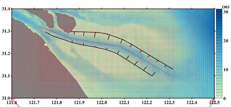
Arab Academy for Science, Technology and Maritime Transport
                     The International Maritime and Logistics Conference “Marlog 8”
                     Towards Global Competitiveness in Maritime Industry
                                    “Investing in Ports”
                                  The Trends, The Future
                                    17 – 19 March 2019

beaches. So sedimentation problem in navigation channel is considered a crucial issue according to
economical and environmental point of view. Many solutions could be used to reduce sediment
volume, but the proper methodologydepends on reasons, volume and sources of sediment which differ
from place to another. Sedimentation problem in different navigation channels will be investigated in
following part to clarify sedimentation process and the influence of different parameters on it.

                          Figure 1: Sedimentation Process in Navigation Channel

SEDIMENTATION PARAMETERS IN NAVIGATION CHANNEL
    Sedimentation process is controlled by geometric of channel, hydrodynamics and protection
structures. Geometric parameters of channel such as depth, width, orientation and length of navigation
channel depend on harbour requirements and dimension of ships that use the channel. Hydrodynamics
parameters such as wind, tide, waves and current differ from location and another. Additional
structures usually used to protect the channel from sedimentation. The priority of each parameter
varies from location to another.

1.1. Geometric parameters
   Figure 2 illustrates Geometric parameters of navigation channel such as the depth, width , side
slope and orientation of channel.
   Orientation of channel should satisfy shortest length and depend on prevailing wind, wave and
current. It is preferable to have the prevailing currents aligned with the channel axis, however usually
the prevailing wind and wave directions are the dominate design parameters.

MARLOG 8                                                                                                   2
Arab Academy for Science, Technology and Maritime Transport
                     The International Maritime and Logistics Conference “Marlog 8”
                    Towards Global Competitiveness in Maritime Industry
                                   “Investing in Ports”
                                 The Trends, The Future
                                   17 – 19 March 2019

                        Figure 2: Geometrical Parameters of Navigation Channel
  Depth of navigation channel depend on many factors such as ship draft, tidal range, ship squat and
wave response, as shown in Figure 3.

                                Figure 3:Channel Depth Parameters [26]

   Width of navigation channel depend on channel capacity, bank clearance, ship manoeuvrability,
bend configuration and environmental forces such as wind, current and waves. [26]
   Geometric parameters have a great effect on sedimentation rate of navigation channel. Annual
amount of dredged material in Otago harbor on the southeast coast of South Island of New Zealand
MARLOG 8                                                                                               3
Arab Academy for Science, Technology and Maritime Transport
The International Maritime and Logistics Conference “Marlog 8”
Towards Global Competitiveness in Maritime Industry
“Investing in Ports”
The Trends, The Future
17 – 19 March 2019
was ranged from 300000 to 400000 m3. 2D numerical simulation modelwas performed to study the
effect of port development and climate changes on sedimentation. Different scenarios were used such
as development of dredging, sea level rise by 0.50 m and using different bathymetric conditions.
Results showed that deepening channel increased dredging demand. [31]
In ST. Marys Entrance, FL/GA border, natural channel with depth 5.8 m was deepened to 10.4 m in
the interval between 1924 and 1954. Then it was deepened to 12.2 in 1974 and to depth 15.5 m at
1988. Sedimentation rate increased from 169000 m3/yr to 618000 m3/yr with 265% increase ratio
when the channel depth increased from 10.4 m to 15.5 m. That’s indicates that dredging rate depends
more on channel depth than any parameter. [27]
Improvement works in harbour basin and entrance channel of Dar el Sallam harbour increased
sedimentation rate from 25 cm/ year to 43 cm/ year. These works included deepening, widening and
straightening channel and installing navigation aids. It was clear that channelorientation was
responsible for increasing of sedimentation rate. The average deposition rate was 168000 m3/yr. [28]
Mojabi M. et. al. (2010) used finite volume method to study the significant parameters effect on
siltation on harbor and navigation channel. Sedimentation rate increased as navigation channel width
increased. Also, channel orientation strongly effect on sedimentation, that decreasing the angle
between channel and current increasing siltation. [23]
El-Toro navigation channel, Bahia Blanca estuary, Argentina required a periodic dredging to
remove 300000 m3 of sediment each year. The channel was acting as a sediment trap because of its
orientation. [25]
1.2. Hydrodynamic parameters
Hydrodynamic parameters such as wind, waves, tide and currents deeply effect on sediment
transport in navigation channel. In Thailand, approach channel of Bangkok harbour is maintained
through continuous dredging of 5million m3/yr of sediment. The high sedimentation rate was caused
by discharged silt from river and due to the effect of waves and tidal current. [9]
In São Francisco do Sul ,navigation channel trapped about 0.35 * 106 m3/ year, and dredged
material disposed at Atlantic Ocean. So, beach system suffers erosion due to the loss of suspended
material that was trapped in navigation channel. As a result of interaction between tidal
currents and waves, the ebb tidal deltas was formed and considered main sedimentation parameter.
However, erosion problems could be mitigated if we use eroded sites as a disposal sites. [2]
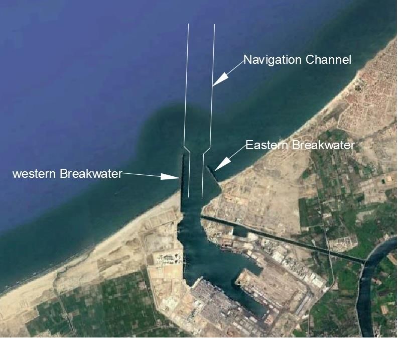
The estimated rate of sediment deposited in navigation channel of LNG port at Abu-Qir bay on North
Western coast of Nile Delta –Egyptwas between 0.048*106 m3/month and 0.388 *106m3/month, with
average annual rate of 1.977 *106 m3/yr, according to mathematical model results. Eroded sediment
from Rosetta was the main source of sediment which transported by wind and wave currents acting on
S-W direction. In the other hand, prevailing current directions N-W and S-E had insignificant effect
that it was flow parallel to the main axis of navigation channel. Also, N-E current had minor effect as
navigation channel was protected by 900 m breakwater in western side, as shown in Figure 4.
It was found that sedimentation consisted of 78 % bed load and 22 % suspended load and
sedimentation rate calculated during winter was greater than that in summer.[8]
MARLOG 8 4Arab Academy for Science, Technology and Maritime Transport
The International Maritime and Logistics Conference “Marlog 8”
Towards Global Competitiveness in Maritime Industry
“Investing in Ports”
The Trends, The Future
17 – 19 March 2019
Figure 4:Wave and Current Pattern at Navigation Channel of LNG port at Abu-Qir bay on North Western coast,
Egypt [8]
Saint John harbour had average rate of siltation ranged between 0.2 to 1 m/ year. Density currents,
tidal exchange and horizontal eddy exchange were the main parameters affected on sedimentation
process at port of Saint John.According to numerical simulation of MIKE21 model, the accumulated
sedimentation rate was 4.2* 106 m3/year.[20]
The entrance channel at Blankenberge harbour, BELGIUM, divided to four zones of siltation with
total amount of sediment reached 165000 m3/yr. It was obvious that, tide, wind and wave significantly
effect on siltation. 2D morphological model called X-Beach showed that western groins weren’t
sufficient to stop sediment. [32]
The deep navigation channel of Yangtze River Estaury, China was constructed at 1998 with 92.0
Km length and average depth of 12.0 m, protected by two dikes with length 48.1 Km and 49.20 Km.
To increase current speed and decrease siltation, 19 groins with total length of 30.0 Km was
constructed with dikes, as shown in Figure 5.Horizontal sediment transport from north to south was
trapped with the dikes. Sediment deposition was caused by tidal asymmetry, river discharge, waves
and wind. However, the wind had the great effect on siltation in navigation channel. [30]
The Yangtze Estuary is the fourth largest river in the world in terms of sediment discharge, that
annual mean is about 60.0–80.0 million m3 . [31]
MARLOG 8 5Arab Academy for Science, Technology and Maritime Transport
The International Maritime and Logistics Conference “Marlog 8”
Towards Global Competitiveness in Maritime Industry
“Investing in Ports”
The Trends, The Future
17 – 19 March 2019
Figure 5:Navigation channel with 92.0 Km length, Protected by Two Dikes with 19 groins. [30]
Due to high siltation volume that reached 1250000 m3 theinternational navigation channel in Dinh
An Estuary, Vietnam, used to be dredged twice a year. The main parameters affected on siltation were
tidal current, sediment load, bathymetry and salinity.[24]
At Mongla port in Bangladish, average sedimentation rate was 0.57 m3/day and maximum rate was
4.89 m3/day, which cause navigational problem. It was found that bed materials of fine sand
contributed one third of total transport of sediment. Contraction of river width was one of suggested
solutions to minimize sediment, but study showed that it couldn’t be useful. However, both
contraction and dredging can be useful. [29]
At Arisaig Harbour , on Nova Scotia, hydrodynamics parameters are the main responsible for
sedimentation process thatlongshore sediment transport is dominated by waves. [20]
A new breakwater and extension of existing rock structures were recently considered to solve
sedimentation issue.[3]
Sediment deposition is the main drawback of the Cuddalore port in south India, that there is heavy
sediment deposit in the entrance channel. Small boats can access the port easily, however the
launchers have to change their route periodically according to tidal range. The estimated amount of
sediment was 0.889 Mm3/year due to wave action. Realignment of existing breakwaters may solve
this problem. [3]
1.3. Protection structure
According to design criteria, geometric parameters are considered design requirements, and
hydrodynamic parameters are considered site constraints. So, protection structures are usually used to
protect the navigation channel from sediment and reduce sediment accumulation. For
example,navigation channel of LNG port at Abu-Qir bay on North Western coast of Nile Delta –Egypt
was protected by 900 m breakwater in western side, as shown in Figure 4. However, in many cases the
protection structure was not sufficient due to improper design.
At Bandy Creak Boat Harbour, Esperance, Western Australia, average cost of dredging was
estimated in 1991 to be 120000 $ to remove about 25000 m3 of sediment. It was clear that, western
breakwater trapped only 16 % of sediment due to insufficient length. [5]
Navigation channel at Damietta port trapped longshore sediment and gained sedimentation with
average rate of 1.39*106 m3 yr-1 at 1992. However, sedimentation rate decreased to 0.80*106 m3 yr-1 at
1995 due to stabilization of bed slopes.[11]
MARLOG 8 6Arab Academy for Science, Technology and Maritime Transport
The International Maritime and Logistics Conference “Marlog 8”
Towards Global Competitiveness in Maritime Industry
“Investing in Ports”
The Trends, The Future
17 – 19 March 2019
It was clear that the protection breakwater didn`t reach the closure depth. So, it was recommended
to extend the length of eastern breakwater to 1.50 km offshore, while the western breakwater should
be extend to1.70 km offshore to reach water depth of 8.0 m. [13]
Table 1 summarize the sediment rates in different harbours and major parameters effect on it.
Tableproves that sedimentation processes threaten navigation in approach channel and consume large
amount of maintenance cost in dredging.
Table1. Sedimentation rates in different harbours
Nation Location Average Main Parameter
Sedimentation Rate
1 United States ST. Marys Entrance Natural 618000 m3/yr Depth
channel inlet
2 New Zealand Otago harbor 350000 m3/yr Deepening
3 Tanzania Dar es Sallam Harbour 168000 m3/yr Channel orientation
4 Argentina El-Toro navigation channel 300000 m3/yr Channel orientation
5 Thailand Approach channel of 5 millions m3/yr Waves and tidal current
Bangkok Harbour
6 Brazil São Francisco do Sul 0.35 * 106 m3/ year Waves and tidal current
Navigation channel
7 Egypt navigation channel of LNG 1.977 *106 m3/yr wind and wave currents
port at Abu-Qir bay
8 Canada Saint John Harbour 4.2* 106 m3/year Current and tidal
exchanges
9 Belgium The entrance channel at 165000 m3/yr Tide, wind and waves
Blankenberge Harbour
10 China Yangtze River Estuary 70 *106 m3/yr Wind
11 Vietnam Navigation channel in Dinh 1250000 m3/yr tidal current
An Estuary
12 Bangladesh Mongla port 1790 m3/yr Bed material
13 India Cuddalore Port 0.889 *106 m3/yr Wave action
14 Australia Bandy Creak Boat Harbour 25000 m3/yr Insufficient protection
structure
15 Egypt Navigation channel at 1.39*106 m3 /yr Insufficient protection
Damietta port structure
From previous, the parameters effect on sedimentation can be conclude in the following
1. Orientation of navigation channel
2. Depth and width of navigation channel
3. Deepening navigation channel
4. Hydrodynamic parameters such as Wind, current, tide and waves
5. Weak protection structure
It was obvious that sediment deposition in harbor and river mouth is considered one of the main
issues in different countries, so many researchers studied the effect of different solutions on
sedimentation process. It was recommended that, sedimentation problems can be eliminated by
MARLOG 8 7Arab Academy for Science, Technology and Maritime Transport
The International Maritime and Logistics Conference “Marlog 8”
Towards Global Competitiveness in Maritime Industry
“Investing in Ports”
The Trends, The Future
17 – 19 March 2019
dredging, using open cycle pumping system or jetties used to bypass sand from upstream to
downstream. [21]
PREVIOUS SOLUTIONS
Geometric parameters such as depth and width depend on port requirements, so they cannot be
used to reduce sedimentation volume. Also, hydrodynamic parameters depend on natural location and
can be considered blocked parameters.
Practical solutions depend on controlling sediment movement by trapping it or redirect it away from
channel, that the geometric and hydrodynamic parameters cannot be modified.
So many researchersstudied the effect of different solutions such as using open cycle pumping system,
construct one way sand trap, extension of existing breakwater, changing orientation of channel
orientation.
1.4. Changing orientation of channel
Different solutionswere investigated to minimize sediment accumulation in El-Toro navigation
channel, Bahia Blanca estuary, Argentina. The best solution was changing orientation of channel
orientation. The proposed solution decreased sedimentation rate from 300000 m3/yr to 113250 m3/yr.
[25]
1.5. Extension of existing breakwater
At Bandy Creak Boat Harbour three alternative solutionswere studied to reduce siltation. It was
clear that, about 21000 m3 of siltation came from the western side, so that extension of existing
western breakwater with different alignment was the first solution. Second one, was breakwater spur
and beach groins east to entrance. Last solution was combination of previous solutions. Entrance
management programme was performed using a certain solution with two stages. First stage included
extend western existing breakwater by 60.0 m and construct one way sand trap east to entrance with
total cost of 665000 $. Second stage included extend breakwater with additional 60.0 m. However,
monitoring program was used to decide the necessity of second stage. Monitoring program show that
1st stage reduced significantly siltation in the entrance. [5]
1.6. Bypassing techniques and sediment trap
In the last decades, bypassing and backpassing techniques used to replenishment beaches by
restoration dredged sediment from navigation channel. these techniques had a great benefit to
environment, neighbouring shore and economy. Also, fluidization system provided a suitable solution
to gain and transfer sand that would be useful in beach nourishment and very suitable in sandy soil.
However, average cost of that system was very high. [7]
Also, the created noise by the system was one of remarkable operation disadvantages. Fixed planets
usually have limited capacity, that the boom had limited area of reach. Also, movable trestle-riding
planets had the same shortage. Clogging by gravel, plastics, sea weed or driftwoodis one of the most
important drawbacks of the system. High unit cost for small volume of dredged material could be a
MARLOG 8 8Arab Academy for Science, Technology and Maritime Transport
The International Maritime and Logistics Conference “Marlog 8”
Towards Global Competitiveness in Maritime Industry
“Investing in Ports”
The Trends, The Future
17 – 19 March 2019
considerable disadvantage according to economic aspect. Finally, the design of bypassing system
requires reliable information to be suitable, effective and economic.[6]
At Navigation channel at Damietta port, Sediment trap minimized siltation with about 79 %.
However, it was suggested to use combination of sediment trap and extension of western breakwater
to decrease siltation by about 84 %. [18]
So, there are many different solutions could be suitable. However, choosingthe proper solution
depends on reasons, volume and sources of sediment and requires accurate and reliable information,
because although in vicinity of these solutions, in many cases the problem is still unsolved.
Table 1 shows that navigation channel of Damietta harbour had one of the highestdeposition rates.
So, it could be a suitable example to clarify sedimentation process and how to mitigate it.
CASE STUDY : DAMIETTA HARBOUR
In 1980s, Egyptian authority decided to establish Damietta harbour on the northeastern of Nile
delta near the New Damietta city to improve trade and economy potential along the Mediterranean
Sea. The selected location 9.7 km west of the Damietta Nile branchwas characterized by minimum
wave and current effect. However, the location was described as one of long-term coastal accretion
area.[11]
The harbour entrance was protected from siltation by two breakwaters. The western breakwater
was constructed parallel to the navigation channel with 1500 m length and extends to a 7.0 m water
depth. The eastern breakwater was constructed perpendicular to shore linewith 500 m length and
extends to 3.0 m water depth. The navigation channel was completed in 1984, with a total length of 20
km and 15 m average depth and 200 m width of inner part that increased to 300 m in outer part as
shown in Fig (6).
MARLOG 8 9Arab Academy for Science, Technology and Maritime Transport
The International Maritime and Logistics Conference “Marlog 8”
Towards Global Competitiveness in Maritime Industry
“Investing in Ports”
The Trends, The Future
17 – 19 March 2019
Figure 6:Layout of Damietta Harbour
The project consultant estimated that the average volume of annual dredged materials was 1.18 x
106 m3/yr . However, the sedimentation rate exceeded this value to reached 2.0 x 10⁶ m3/yr in 1990.
According to the Damietta Port Authority, the unit cost of maintenance dredging in 1988 was 0.23
Euro /m3 and had reached 1.10 Euro/m3 in 2001. In 2004, the yearly cost of maintenance the access
channel of Damietta harbour had reached 7.1 million Euro. [1]
Figure 7 show sediment rates and dredging costs in the interval between 1985 and 2015, with
maximum sediment rate of 2 million m3.
Figure 7:Sediment Volume from Navigation Channel of Damietta Harbour and Annual Dredging Cost since
1985 to 2015 [14]
MARLOG 8 10Arab Academy for Science, Technology and Maritime Transport
The International Maritime and Logistics Conference “Marlog 8”
Towards Global Competitiveness in Maritime Industry
“Investing in Ports”
The Trends, The Future
17 – 19 March 2019
Damietta harbor and Damietta promontory were considered two main zones of erosion due to
construction of Aswan High Dam and cut of sediment discharge, also construction of coastal
protection works deeply effected on shoreline. Construction of Damietta harbor had affected long
shore current sediment, that western side of harbor had accretion rate of 12.0 m3/year. On the other
hand, the eastern side suffered from erosion with maximum rate -39 m/yr. The shoreline between
harbor and Ras El-Bar was subjected to sediment movement westward due to seasonal reversal current
that generated by waves from NE direction. [12]
It is found that, harbor jetties interrupted eastward moving littoral drift. So, western beach had
accretion of fine mean grain size sand with average rate of 25m yr-1 during interval from 1983 to 1993,
as shown in figure 8.a. In the other hand, eastern shoreline was losing coarse sand that was trapped in
navigation channel, as shown in figure 5.b. Navigation channel trapped longshore sediment and gained
sedimentation with average rate of 1.39*106 m3 yr-1 at 1992. However, sedimentation rate decreased
to 0.80 *106m3yr-1 at 1995 due to stabilization of bed slopes. [11]
Figure 8:a)Accretion in Western Side of Damietta Habour b)Erosion in Eastern Side of Damietta Harbor (from
1984 to 1991) [10]
It is obvious that construction of Damietta harbor had a greater effect more than expected that
effect extend for about 10.50 Km of shoreline. So, sedimentation in channel has economical effect of
maintenance cost and environmental effect on adjacent beach.
N-E orientation on approach channel trapped sediment moving from east or west, and navigation
channel acted as a sediment sink from different direction. Figure 9 shows the current pattern around
navigation channel that longshore currents were generated by predominated wave directions which
were found to be N.N.W , N.W. and W.N.W and transported sediment from eroded beach of Burullus .
Also, waves from N-E sector generate a reversed longshore current southwest and bring sediment
from Ras El-Bar beach and damping site navigation channel. In addition, offshore and onshore current
was responsible for siltation. Sediment accumulated at first four kilometres of navigation channel at
harbour entrance was about 65% of total sediment, and navigation channel reach balance at distance of
9.0 km offshore. It was concluded that the length of existing breakwaters were less than required
length to reach closure depth. So, it was recommended to extend the length of eastern breakwater 1.50
km offshore to reach water depth of 8.0 m. in the other hand the western breakwater should be extend
to1.70 km offshore to each the same depth. [13]
MARLOG 8 11Arab Academy for Science, Technology and Maritime Transport
The International Maritime and Logistics Conference “Marlog 8”
Towards Global Competitiveness in Maritime Industry
“Investing in Ports”
The Trends, The Future
17 – 19 March 2019
Figure 9:Sedimentation Processes at the Navigation Channel of Damietta harbour. [13]
At Damietta promontory current reversals and littoral drift to west could be neglected because of
orientation of shore line at Damietta promontory. So, eroded beach from Damietta promontory was
transported to east and curvilinear sand spit was formed and did not effect on navigation channel, as
shown in Figure 10.[19]
Figure 10:Curvilinear Sand Spit in Eastern Side of Damietta Promontories[18]
MARLOG 8 12Arab Academy for Science, Technology and Maritime Transport
The International Maritime and Logistics Conference “Marlog 8”
Towards Global Competitiveness in Maritime Industry
“Investing in Ports”
The Trends, The Future
17 – 19 March 2019
Natural beachesare influenced by many factors such as incoming waves, alongshoreand cross-shore
currents in the surf zone, wind-drivencurrent outside the surf zone, and constantly changingtides.[21]
At Ras El Bar area, shoreline showed accretion area beyond detached breakwater with average rate
9 m/yr, and erosion area in the region between detached breakwater and eastern jetty of Damietta
harbour with average rate -13m/yr. According to field measurements, predominate longshore current
directed southwest with average velocity 30 cm/s, as shown in Fig (11) . Grain sorting studies showed
that waves and longshore current were responsible for eroded sand from beach face and transport sand
alongshore and deposit in accretion area.[16]
Figure 11:Predominate Longshore Current Directed Southwest (47 % ) with Average Velocity 30 cm/s. [16]
ABO BAKER. I. ABO ZED (2007) studied dynamic factors that effect on sedimentation
processes in navigation channel of Damietta port. Studied area consisted of Gamasa drain, Damietta
harbor and Damietta shore line and Damietta promontory. Author showed that, N-NW waves were
responsible for predominate long shore current westward. However, small portion of wave act on S-E
direction that generates a reversely current during winter and spring. It was found that, during winter
season maximum current speed was generated toward SSW that led the redistribution of eroded
sediment.So, navigation channel interrupt sediment movement from various direction such as back
part of dredged sediment from damping location, eroded beach of El Brullus and Ras el bar ,
submerged Damietta shoals and Damietta promontory. Author concluded that existing breakwaters
were not sufficient to trap sand bypassing from various directions. [1]
From previous we can conclude that:
1. N-E orientation on approach channel trapped sediment moving from east or west.
2. Navigation channel interrupt sediment movement from various direction such as back part of
dredged sediment from damping location, eroded beach of El Brullus and Ras el bar.
3. The existing breakwaters were not sufficient to trap sand bypassing from various directions.
M. A. Gad et al. (2013)used multicomponent numerical model to minimize the volume of dredged
materials in Damietta navigation channel. Authors used data of bathymetry, wind and current in
interval from 1989 to 1997. They suggested four solutions with 13 configurations by modifying
existing breakwaters, as shown in figure 12. Results show that sediment transport from western side
reduced by about 62-74 % and from eastern side reduced by about 60-70%. However, study focused
on first 5.0 Km of navigation channel and neglect sedimentation in the rest of it as it is in deep water
MARLOG 8 13Arab Academy for Science, Technology and Maritime Transport
The International Maritime and Logistics Conference “Marlog 8”
Towards Global Competitiveness in Maritime Industry
“Investing in Ports”
The Trends, The Future
17 – 19 March 2019
and sedimentation is insignificant. It was obvious that maximum sedimentation occurred in the area
between the tips of two breakwaters and sedimentation depth reached 3.0 m. Among various
modifications, results showed that modification to western breakwater is the worst solution. In the
other hand modification to eastern breakwater showed better results.[17]
Figure 12:Four Modification to Existing Breakwater to Reduce Sedimentation in Navigation Channel of
Damietta Harbor.[17]
The results weren’tcompatible with previous researches that proved that main sediment source
came from western side.
Khalifa, A. M. (2017) used number of scenarios such as using extension the western jetty , using
submerged breakwater , current deflector wall (CDW) and sediment trap to minimize sedimentation
volume in navigation channel of Damietta harbour using 3D numerical model. Using submerged
breakwater was the worst solution, as sediment passed above breakwater crest and settle in navigation
channel. Current deflector wall significantly decreased sedimentation volume, however current speed
in approach channel threatened navigation. Extension of western jetty wasn’t sufficient solution, that
dredged material decreased by about 37 %. Sediment trap minimized siltation with about 79 % to be
the best solution among previous alternatives. However, author suggested using combination of
sediment trap and extension of western breakwater to decrease siltation by about 84 %. Fixed pump
system was recommended to install to exchange siltation gained in sediment trap. [18]
Using pumping system could have disadvantages of maintenance, operation and initial costs which
neglected in study. Also, results disagreed with M. A. Gad et al. suggestions.
In 2017 Damietta harbour authority decided to improve the navigation channel to accommodate the
improvement in berths and development in ship industry. The sedimentation problem could be
aggravated due to channel improvement, and even suggested solution could be useless.
MARLOG 8 14Arab Academy for Science, Technology and Maritime Transport
The International Maritime and Logistics Conference “Marlog 8”
Towards Global Competitiveness in Maritime Industry
“Investing in Ports”
The Trends, The Future
17 – 19 March 2019
In 2018, M. Bahgat made numerical simulation for different scenarios to mitigate sediment volume
in navigation channel of Damietta harbour using Delft 3D software package. Results showed that,
construction of sand trap either offshore or onshore at the western side of the harbour will not have
significant impact on minimizing the sediment deposition inside the approach channel.Also, increasing
the length of western jetty has no significant effect of sedimentation in navigation channel. The
proposed solution is to increase the length of eastern jetty with 450 m to reach the depth of 5.5 m. it
will decrease the sediment volume by about 40 %. However, according to the study the proposed
solution is not sufficient in case of development of approach channel. [4]
Table2. Illustrates the previous studies and proposed solutions to mitigate sediment deposition in
navigation channel.
Table 2. Summarise of Previous Studies
Authors Used Model Main Conclusions Proposed Solution Sediment
Western Jetty Eastern Construction reduction
Jetty of Sand Trap
M. A. Gad Multi Modification Should - Increasing eastern 68 %
et al. (2013) component was the worst be jetty by 700 m.
numerical solution increased
model .
Khalifa, A. Delft 3D Decrease No need Decrease Construction of sand 84 %
M. (2017) sediment for sediment trap and extension of
volume modificat volume western jetty by
ion 100m.
M. Bahgat Delft 3D Had no impact Should No Increasing eastern 40 %
(2018) be significant jetty by 700 m.
increased effect
.
The conflict between recommended solutions proves that sedimentation problem in Navigation
channel of Damietta harbour needs more accurate study to find the proper way to solve the problem.
Also, suggested solutions either failed or had not examined in case of development of approach
channel.So, comprehensive study is needed to reach the optimum solution for the sedimentation
problem of Damietta navigation channel problem especially in case of development.
According to previous research,practical solutions depend on controlling sediment movement by
trapping it or redirect it away from channel by many ways such as:
1. Using open cycle pumping system.
2. Construct one way sand trap.
3. Extension of existing breakwaters.
4. Changing orientation of channel.
However,the main target of study is to minimize the periodic maintenance cost. So, using open
cycle pumping system isn’t the best solution because of average cost of that system is very high and
required periodic cost for operation and maintenance.
MARLOG 8 15Arab Academy for Science, Technology and Maritime Transport
The International Maritime and Logistics Conference “Marlog 8”
Towards Global Competitiveness in Maritime Industry
“Investing in Ports”
The Trends, The Future
17 – 19 March 2019
Constructing sand trap is considered a temporary solution that accumulated sediment in sand trap will
be dredged with the same cost. So, this solution has the advantage of moving dredging site away of
navigation channel to avoid obstruction of ships movement in the period of dredging.
Changing orientation of channel could be unsuitable choice in case of existing harbour, that
consumes huge cost and may causeawkwardness in ships movement.
Extension of existing breakwaters or using additional structuresis considered the most practical
solution that it is permanent, applicable alternative and doesn’t need periodic cost. So, this solution
can be considered the most suitable solution to minimize the sediment in navigation channel of
Damietta harbour.
CONCLUSION
Sedimentation processes threaten navigation in approach channel and consume large amount of
maintenance cost in dredging and has environmental effect on adjacent beach.
The parameters effect on sedimentation can be conclude in the following:
1. Orientation of navigation channel
2. Depth and width of navigation channel
3. Deepening navigation channel
4. Hydrodynamic parameters such as Wind, current, tide and waves
5. Weak protection structures
However geometric parameters and hydrodynamic parameters can be considered blocked
parameters. So, practical solutions depend on controlling sediment movement by trapping it or redirect
it away from channel by many ways such as:
1. Using open cycle pumping system.
2. Construct one way sand trap.
3. Extension of existing breakwater.
4. Changing orientation of channel orientation.
However, Extension of existing breakwaters or using additional structures is considered the most
practical solution that it is permanent, applicable alternative and doesn’t need periodic cost. So, this
solution can be considered the most suitable solution to minimize the sediment in navigation channel.
Damietta harbour on the northeastern of Nile delta in Egypt is a clear example of sedimentation
problem, that navigation channel trapping a huge volume of sediment reached 2 million cubic meters
per year, and requires high cost periodic maintenance.The clear conflict between recommended
solutions proves that Sedimentation problem in Navigation channel of Damietta harbour needs more
accurate study to find the proper way to solve the problem. So, comprehensive study is needed to
reach the optimum solution for the sedimentation problem of Damiettanavigation channel problem
especially in case of development.
MARLOG 8 16Arab Academy for Science, Technology and Maritime Transport
The International Maritime and Logistics Conference “Marlog 8”
Towards Global Competitiveness in Maritime Industry
“Investing in Ports”
The Trends, The Future
17 – 19 March 2019
REFERENCES
1. Abo Zed, A. B. “Effect of Waves and Current on the Siltation Problem of Damietta Harbour, Nile Delta
Coast, Egypt,” Mediterranean Coastal Engineering, Vol. 46,2007,pp 127-138.
2. Angulo, R. J., Souza, M. D., & Lamour, M. R.“Coastal erosion problems induced by dredging activities in
the navigation channel of Paranaguá and São Francisco do Sul harbor, southern Brazil,” Journal of Coastal
Research, Vol. 39, 2006, pp 1801-1803.
3. Aravindan, S. and Thiruvenkatasamy, K. “Modelling Coastal Sediment Transport for Harbour Planning,”
Indian Journal of Geo Marine Sciences, Vol. (02), 2017,pp 405-413.
4. Bahgat, M. “Mitigation measures for sediment deposition problem inside the approach navigation channel of
Damietta harbour,” Hydraulic Research Institute report, July 2018, 49 p.
5. Boreham, P. “Sand Bypassing at Bandy Creek Boat Harbour, Esperance, Using an offshore breakwater,” 10th
Australasian conference on coastal and ocean engineering, Auckland, 2-6 Dec. 1991, pp 553-558.
6. Bruun, P.“Navigation and sand Bypassing at Inlet: Technical Management and Cost Aspect,” Journal of
Coastal Research, Vol. 23,1996, pp113-119
7. Bruun, P. ad Willekes, G. “Bypassing and Backpassing at Harbors, Navigation Channels, and Tidal
Entrances: Use of Shallow-Water Draft Hopper Dredgers with Pump-Out Capabilities,” Journal of Coastal
research, Vol. 8 , No. 4 ,1992, pp 972 – 977
8. Deabes, E. “Sedimentation Processes at The Navigation Channel of Liquid Natural Gas (LNG),Nile Delta,
Egypt,” International Journal of Geosciences Coastal Research ,2010, pp 14-20.
9. Deguchi, I., Sawaragi, T., Ono, M., & Koontanakulvong, S. “Mechanism and estimation of sediment in
Bangkok Bar Channel,” Coastal Engineering1994, pp 3002- 3015
10. El-Asmar, H.M. ,Taha, M. N. and El-Sorogy, A. S.“Morphodynamic Changes as an Impact of Human
Intervention at the Ras El-Bar-Damietta Harbor coast, NW Damietta Promontory, Nile Delta, Egypt,” Journal
of African Earth Science, Vol. 124, 2016,pp 323-339.
11. El-Asmar, H.M. and White, K. “Changes in Coastal Sediment Transport Processes Due to Construction of
New Damietta Harbour, Nile Delta, Egypt,” Coastal Engineering, Vol. 46,2002, pp 127-138.
12. Frihy, O. E. , Dewidar, K. M and El Banna, M. M. (1998). “Natutal and Human impact on Northeastern Nile
Delta Coast of Egypt,” Journal of Coastal Research, Vol. 14 , No. 3, pp 1109-1118.
13. Frihy, O. E., Badr, A. and Hassan, M. S. “Sedimentation Processes at The Navigation Channel of the
Damietta Harbour on the Northeastern Nile Delta Coast of Egypt,” Journal of Coastal Research, Vol.
18,2002, pp 459-469.
14. Frihy, O. E., Deabes, E.A. and Helmy, E. “Compatibility Analysis of Dredged Sediments from Routine
Pathways and Maintenance of Harbor’s Channels for Reuse in Nearshore Nourishment in the Nile Delta,
Egypt,” Journal of Coastal Research, Vol. 32, No 3,2016, pp 555-566.
15. Frihy, O. E., Hassan, M. S., Deabes, E. A. and Badr, A. “Seasonal Wave Changes and the Morphodynamic
Response of the Beach-Inner Self of Abu-Qir Bay, Mediterranean Coast, Egypt,” Marine Geology , Vol. 247,
2008, pp 145-158.
16. Frihy, O.E. , El Banna, M. M. and El Kolfat , A. I. “Environmental Impacts of Baltim and Ras El Bar Shore-
Parallel Breakwater Systems on the Nile Delta Littoral Zone, Egypt,” Environmental Geology, Vol. 45,2004,
pp 381-390.
17. Gad, M. A., Saad A., El-Fiky, A. and Khaled, M. “Hydrodynamic Modeling of Sedimentation in The
Navigation Channel of Damietta Harbor In Egypt,” Coastal Engineering Journal, Vol. 55, No. 2, 2013, pp 1-
31.
18. Khalifa, A. M. “Controlling Sedimentation problems of Damietta Harbor Navigation Channel Using
Numerical Modelling,” M.SC. Thesis, Alexandria University faculty of engineering, Alexandria, 2017, 150
p.
19. Lawrence, D. and Frihy, O. “Evolution of The Modern Nile Delta Promontories: Development of Accretional
MARLOG 8 17Arab Academy for Science, Technology and Maritime Transport
The International Maritime and Logistics Conference “Marlog 8”
Towards Global Competitiveness in Maritime Industry
“Investing in Ports”
The Trends, The Future
17 – 19 March 2019
Features during Shoreline Retreat,” Environmental Geology, Vol. 46, 2004, pp 914-931.
20. Leys, V. and Ryan P. Mulligan, R.P. (2011). “Modelling Coastal Sediment Transport for Harbour Planning:
Selected Case Studies,” Sediment Transport, Dr. Silvia Susana Ginsberg (Ed.), ISBN: 978-953-307-189-3,
InTech, Available from: http://www.intechopen.com/books/sediment-transport/modelling-coastal-
sedimenttransport-for-harbour-planning-selected-case-studies
21. Lin, Lihwa, and Zeki Demirbilek. “CMS: A Coastal Modeling System for inlets and navigation
projects,” proceedings of the 5th International Ocean-Atmosphere Conference. 2010.
22. Masria, A. , Negm, A. , Iskander. M. and Saavedra, O.“Coastal Zone Issues : a Case Study ( Egypt) ,”
Procedia Engineering, Vol. 70 ,2014, pp 1102-1103
23. Mojabi M. , Hejazi K. and Toosi K.N. “A Numerical Study on Harbor and Approach Channel Planform
Effects on Sedimentation Using F.V.M,” The 9th International Conference on Coasts, Ports and Marine
Structures (ICOPMAS 2010) 29 Nov.-1 Dec. 2010 (Tehran).
24. Nguyen, V. T., Zheng, J. H., & Zhang, J. S. “Mechanism of Back Siltation in Navigation Channel in Dinh An
Estuary, Vietnam. ,” Water Science and Engineering,Vol. 6, No. 2, 2013, pp 178-188
25. Perillo G. M. and Cuadrado D. “Geomorphologic Evolution of E1 Toro Channel, Bahia Blanca Estuary
(Argentina)Prior to Dredging ,” Marine Geology, Vol. 97 , 1991, pp 405-412
26. PIANC, W.“Harbour Approach Channels Design Guidelines,” Report of Marcom Working Group, 2014,
49 p.
27. Rosati, J. D., & Kraus, N. C. “Rapid Methods for Estimating Navigation Channel Shoaling,” WEDA 29th
Technical Conference & 40th TAMU Dredging Seminar,2009,17 p.
28. Sanga, I.P.L. and Dubi, A.M. “ Impact of Improvement of entrance Channel on the Rate of Sediment
Deposition into the Dar es Salam Harbour,” Western Indian ocean J. Mar. Sci., Vol. 3, 2004, pp 105-112.
29. Sarker, T. “Sedimentation processes at the navigation channel of Mongla port on the Pussur-Sibsa river
system in Bangladesh,” European Academic Research, Vol. III, Issue I, 2015, pp 787-798
30. Song, D. and Wang, X. “ Suspended Sediment Transport in the Deepwater Navigation Channel Yangtze
River Estuary, China, in the Dry Season 2009: 2. Numerical Simulations,” Journal of Geophysical Research :
Oceans, Vol. 118, 2013, pp 5568-5590.
31. Wilson, G. and Sutherland, A. J.“Numerical Modelling of Oatago Harbour,” 10th Australasian conference on
coastal and ocean engineering, Auckland, 2-6 Dec. 1991, pp 481-486.
32. Xu, T.L., Mao, X.D., Chen, W., Kuang, C.P. and Mao, C.H. “Numerical Simulation of the Hydrodynamic
Response of Regulation Engineering in the Deepwater Navigation Channel of the Yangtze
Estuary,”Proceeding of the 5th International Technical Conference on Hydraulic Engineering (CHE V), 15–
17 December 2017, Shanghai, P.R. China, pp 195-200.
33. Zimmermann, N., Trouw, K., Wang, L., Mathys, M., Delgado, R., & Verwaest, T. “Longshore Transport and
Sedimentation in a Navigation Channel at Blankenberge (BELGIUM) ,”Coastal engineering 2012, pp 1-16.
i
Prof. Dr. Osami Saeed Rageh professor of Harbour Engineering at Hydraulics and Irrigation Department,
Faculty of Engineering , Mansoura University.
MARLOG 8 18You can also read