A (NOT SO) BRIEF HISTORY OF LUNAR DISTANCES: LUNAR LONGITUDE DETERMINATION AT SEA BEFORE THE CHRONOMETER - arXiv
←
→
Page content transcription
If your browser does not render page correctly, please read the page content below
A (NOT SO) BRIEF HISTORY OF LUNAR DISTANCES:
     LUNAR LONGITUDE DETERMINATION AT SEA BEFORE THE CHRONOMETER

                                      Richard de Grijs
                 Department of Physics and Astronomy, Macquarie University,
                       Balaclava Road, Sydney, NSW 2109, Australia
                             Email: richard.de-grijs@mq.edu.au

Abstract: Longitude determination at sea gained increasing commercial importance in the late Middle
Ages, spawned by a commensurate increase in long-distance merchant shipping activity. Prior to the
successful development of an accurate marine timepiece in the late-eighteenth century, marine
navigators relied predominantly on the Moon for their time and longitude determinations. Lunar eclipses
had been used for relative position determinations since Antiquity, but their rare occurrences precludes
their routine use as reliable way markers. Measuring lunar distances, using the projected positions on
the sky of the Moon and bright reference objects—the Sun or one or more bright stars—became the
method of choice. It gained in profile and importance through the British Board of Longitude’s
endorsement in 1765 of the establishment of a Nautical Almanac. Numerous ‘projectors’ jumped onto
the bandwagon, leading to a proliferation of lunar ephemeris tables. Chronometers became both more
affordable and more commonplace by the mid-nineteenth century, signaling the beginning of the end for
the lunar distance method as a means to determine one’s longitude at sea.

Keywords: lunar eclipses, lunar distance method, longitude determination, almanacs, ephemeris tables

1 THE MOON AS A RELIABLE GUIDE FOR NAVIGATION

As European nations increasingly ventured beyond their home waters from the late Middle
Ages onwards, developing the means to determine one’s position at sea, out of view of
familiar shorelines, became an increasingly pressing problem. While latitude determination
only required one to measure the height of the Sun above the horizon at its local meridian
passage (i.e., at local noon), or that of Polaris, the North Star, at night, accurate longitude
determination relies on knowing one’s local time precisely with respect to that at a reference
location. Prior to the development and general availability—and affordability—of accurate
marine timepieces, careful observations of bright celestial objects were pursued as potentially
viable alternative means to position determination.

       In this article, I aim to provide a comprehensive review of historical applications to
determine one’s longitude at sea based on careful observations of the Moon. Perhaps
surprisingly given these methods’ importance in the history of maritime navigation, reviews of
lunar longitude methods are often narrowly constrained in their focus, and so any scholar
interested in obtaining a complete picture of the relevant developments must consult a wide
range of sources, not all easily accessible. An exception is Cotter’s (1968) A History of
Nautical Astronomy, but that latter publication is no longer easily available. I will start by
examining the use of lunar eclipses as reliable way markers, followed by a detailed exposition
of so-called ‘lunar distance methods’ which became the most important shipboard techniques
in use prior to the general adoption of chronometers.
                                                                                                       1
        The ancient Greek astronomer, Hipparchus of Nicaea (190–120 BCE; see Figure 1),
was convinced that accurate and internally consistent geographic maps should be based only
on astronomical measurements of latitudes and longitudes, combined with triangulation. He
adopted a zero meridian through Rhodes, in the eastern Mediterranean. Hipparchus
suggested that one could determine positions East and West of his reference meridian by
comparing the local time to the ‘absolute’ time determined at his zero meridian. He was the
first to suggest that geographic longitude could be determined based on simultaneous
observations of solar and lunar eclipses from geographically distinct locales:

       Many have testified to the amount of knowledge which this subject requires, and Hipparchus, in
       his Strictures on Eratosthenes, well observes, “that no one can become really proficient in
       geography, either as a private individual or as a professor, without an acquaintance with
       astronomy, and a knowledge of eclipses. For instance, no one could tell whether Alexandria in
       Egypt were north or south of Babylon, nor yet the intervening distance, without observing the
       latitudes. Again, the only means we possess of becoming acquainted with the longitudes of
       different places is afforded by the eclipses of the sun and moon”. Such are the very words of

                                                                                                      1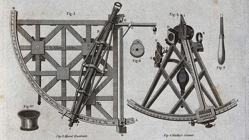
Hipparchus. (Strabo, 7 BCE: Book 1, Ch. 1)

Figure 1: Portraits of the main characters driving the developments described in this paper, ordered from left to
right and from top to bottom by date or birth. Individuals depicted include (i) Hipparchus of Nicea (190–120 BCE);
(ii) Jia Kui (30–101 CE); (iii) Ptolemy (c. 100–c. 170 CE); (iv) Liu Hong (129–210 CE); (v) Regiomontanus (1436–
1476); (vi) Columbus (c. 1451–1506); (vii) Vespucci (1454–1512); (viii) Werner (1468–1522); (ix) de las Casas (c.
1484–1566); (x) Apianus (1495–1552); (xi) Morin (1583–1656); (xii) Newton (1642–1726/7); (xiii) Flamsteed (1646–
1719); (xiv) Halley (1656–1741); (xv) Hadley (1682–1744); (xvi) Bradley (1693–1762); (xvii) Euler (1707–1783);
(xviii) de Lacaille (1713–1762); (xix) Mayer (1723–1762); (xx) Cook (1728–1779); (xxi) de Lalande (1732–1807);
(xxii) Maskelyne (1732–1811); (xxiii) de Borda (1733-1799); (xxiv) Lyons (1739–1775); (xxv) von Zach (1754–
1832); (xxvi) de Mendoza y Ríos (1763–1816); (xxvii) Norie (1772–1843); (xxviii) Slocum (1844–1909).
Figure credits: Wikimedia Commons (public domain), except for (i) http://www.ph.surrey.ac.uk/astrophysics/files/hipparchus.gif;
(ii) https://www.epochtimes.com/gb/19/9/20/n11535183.htm; (iv) https://xw.qq.com/amphtml/20181109A1R8ZX00; (xiii) Creative
Commons Attribution 4.0 International license; (xiv) National Portrait Gallery, NPG 4393; (xvi) NPG 1073; (xx) National Maritime
Museum, BHC2628; (xxi) Joconde database entry 50350212050 (public domain); (xxiv) Cambridge University Library; (xxvi)
Museo Naval de Madrid, Creative Commons CC0 1.0 Universal Public Domain Dedication; (xxvii) NPG 1131; (xxviii) U.S. Library
of Congress, Prints and Photographs division, digital ID cph.3b46344 (out of copyright).
In fact, Hipparchus was the first to realise that one’s longitude can potentially be
determined by means of accurate time keeping (de Grijs, 2017: Ch. 2).

       Meanwhile, halfway around the world, Chinese astronomers were already skilled in
using lunar eclipses to determine their local longitude (Menzies, 2012). Their procedure
involved a rather cumbersome process, however. It required synchronous time
measurements across long distances and a base observatory in China. Observers at both the
base observatory and the location of interest identified unique bright stars that passed
through the local meridian at the moment the Moon started to reappear after an eclipse. Upon
the travelling astronomers’ return to their base observatory, both observation records were
compared. A second measurement was obtained to determine the exact time difference of
the meridian passages of the stars selected at each observing location. The measured time
difference corresponded directly to the difference in longitude between both localities.

         In addition, Chinese astronomers have long known about the Moon’s irregular
                                  2
motion. The astronomer Jia Kui (30–101 CE) was the first to address the Moon’s irregular
motion in the context of calendar design. In early records from 206 CE, Liu Hong used a
linear interpolation method in his Qianxiang li to describe the Moon’s daily motion (Qu, 2000).
Liu’s method retained the Moon’s mean daily motion although adjusted for the orbit’s intraday
deviations. The Moon’s elliptical orbit around the Earth causes it to travel faster across the
sky at perigee (when the Moon is nearest the Earth) and slower at apogee.

        The Moon’s apparent motion takes it 360 degrees around the Earth to its original
projected position among the ‘fixed’ background stars in approximately 27.3 solar days. This
corresponds to an average of 13 degrees per day, or slightly more than half a degree per
hour. While the fixed stars appear to move westwards because of the Earth’s rotation, the
Moon appears to describe a retrograde orbit in the eastward direction. The Moon appears to
speed up when going towards the Sun and slow down when retreating. Its change in
apparent motion also depends on the Earth’s orbital position. The Moon’s tilted orbit with
respect to that of the Earth, inclined under an angle of 5.15°, causes it to perceptibly nod back
and forth along its path.

         Since Liu Hong’s first attempt at linear orbital interpolation, Chinese astronomers
have used a range of interpolation methods to predict the Moon’s ‘equation of centre’. Early
accurate predictions of the lunar motion across the sky were obtained through the piecewise
parabolic interpolation proposed by Liu Zhuo (544–610 CE; Qu, 2000). This method was
further improved, using third-degree interpolation (although for the irregular solar motion), in
compiling the Shoushi (1280) calendar by Guo Shoujing (1231–1316; Li and Du, 1987), the
Chinese astronomer, engineer and mathematician whom the Jesuit astronomer Johann Adam
Schall von Bell (1591–1666) called the ‘Tycho Brahe of China’.

       By simply measuring the angle on the sky between the Moon when it crosses the local
meridian and a given star, one can calculate the local longitude. This requires only access to
a sextant and a telescopic viewing instrument with a graduated arc to measure angles
between specific points of observation, without the need for an accurate clock. This thus
implies that Chinese astronomers would have been able to accurately calculate lunar
positions on the sky since the Yuan Dynasty (1271–1368). In turn, this would have allowed
them to compile ephemeris tables listing the projected positions of the Moon and a set of
carefully selected bright reference stars throughout the year. This approach is, in fact,
equivalent to the lunar distance method employed by European astronomers several
centuries later. The method involved angular measurements on the sky of the distances
between the Moon and a range of celestial objects (see Section 2).

        While medieval Chinese astronomers had thus made significant progress in
understanding the detailed lay of their land based on celestial observations, much of Europe
was languishing in an environment dominated by religious intolerance and wars. Progress in
science, technology and innovation was largely stifled.

        On 3 August 1492, Christopher Columbus embarked on his first transatlantic voyage
to discover ‘Islands and Mainlands’, with royal patronage. Columbus was familiar with

                                                                                               3
Claudius Ptolemy’s (c. 100–c. 170 CE) work, particularly with his description of what may be
the earliest record of a difference in longitude. On 20 September 331 BCE, Alexander the
Great’s Macedonian army had witnessed a widely reported total lunar eclipse at its
encampment near Gaugamela/Arbela (present-day Erbil, northern Iraq; Westfall and
Sheehan, 2015). Ptolemy recorded that the eclipse was seen at the fifth hour of the night. In
Carthage (near present-day Tunis, Tunisia), however, the eclipse occurred at the second
hour of the night. This timing difference thus implied a distance between Arbela and Carthage
of 45 degrees (Evans, 1998: 51), that is, 3 hours times the Earth’s rotation rate of 15 degrees
per hour. The actual longitude difference between both localities is, however, only 33
degrees. This large error is most likely attributable to the lack of information on when during
the eclipse it was observed in either location (at the onset, at mid-totality?), as well as to
difficulties related to the precision of local timekeeping (Westfall and Sheehan, 2015).

         Applications of geographically distinct naked-eye observations of lunar eclipses to
longitude determination became more successful in medieval Europe (Wright, 1922: 244–
246; Woodward, 1987). Walcher of Malvern, the theological scholar and astronomer, obtained
reliable results from simultaneous observations in England and Italy of the lunar eclipses of
30 October 1091, 18 October 1092 and those occurring in 1107–1112 (Wright, 1922: 244–
246; Cortesão, 1969: 182–183). Later in the twelfth century, the astronomer and alchemist
Roger of Hereford used simultaneous observations of the lunar eclipse of 12 September 1178
from Hereford, Marseilles and Toledo to calculate their longitudes with respect to that of Arin,
the mythical centre of the Islamic world.

        Columbus would thus have been familiar with the use of lunar eclipses as a means of
longitude determination. In fact, he is known to have owned a copy of the 1474 Kalendarium,
the astronomical almanac prepared by Johannes Müller von Königsberg (better known as
Regiomontanus; 1436–1476), which predicted the times of lunar eclipses for the next 30
years. Columbus carried a copy of the almanac with him on at least his first transatlantic
voyage (Morison, 1942: vol. I, 653–654; Morison, 1955). In fact, he reportedly observed a
lunar eclipse while in the Americas:

        He declared also from the observation of his people that when in the year of our Lord 1494
        there appeared an eclipse in the month of September, it was seen in Española four hours
        before that it was visible in Spain. (Thacher, 1903: 192, 195)

        On September 15th by the mercy of God they sighted an island which lies off the eastern end
        of Española … in the middle of a great storm he anchored behind this island … That night he
        observed an eclipse of the moon and was able to determine a difference in time of about five
        hours and twenty-three minutes between that place and Cádiz. (Colon and Keen, 1992: 48)

        Columbus himself also reported to have observed this particular eclipse (West and
Kling, 1991: 226–227):

        In the year 1494, when I was at the island of Saona, which is at the eastern end of the island of
        Hispaniola, there was an eclipse of the moon on the 14th of September, and it was found that
        there was a difference from there to the Cape of St Vincent in Portugal of five hours and more
        than one half,

a claim he repeated in a letter of 7 July 1503 to King Ferdinand II of Aragon and Queen
Isabella I of Castile:

        In the year ninety-four I navigated in twenty-four degrees [of latitude] to the westward to the
        end of nine hours, and I cannot be in error because there was an eclipse. (Jane, 1988: 82)

This was confirmed by Bartolomé de las Casas (c. 1484–1566), Bishop of Chiapas, in his
Historia de las Indias:

        From the end of Cuba (that is seen in Hispaniola), which was called the End of the East, and
        by another name Alpha and Omega, he sailed westward from the southern part, until he
        passed the end of ten hours on the sphere, in such a way that when the Sun set to him, it was
        two hours before rising to those that lived in Cádiz, in Spain; and he says that there couldn’t be

                                                                                                        4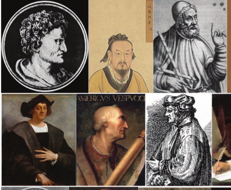
any error, because there was an eclipse of the Moon on the 14th of September, and he was
        well prepared with instruments and the sky was very clear that night, (de las Casas, 1951: 309)

and once again in a later chapter, although there de las Casas (1951: 395–396) reports a
longitude difference of 5 hours 23 minutes West of Cádiz.

        These historical records leave us with an unsatisfactory accuracy of Columbus’
longitude determination. Pickering (1997) tried to disentangle the underlying causes of these
discrepancies. The correct, modern longitude difference between Saona Island and Cádiz is 4
hours 10 minutes. If Columbus had based his measurements on Regiomontanus’ (1489)
almanac readings, he would have made a small mistake, since Regiomontanus’ predicted
time was 24 minutes late (see also Pickering, 1997)—he would thus have concluded that, at
his observation point at Saona, he was 4 hours 34 minutes West of Cádiz.

         The six longitude differences reported in the contemporary, primary records include
five different measurements which are discrepant with respect to the actual difference by
anywhere from 34 minutes to more than five hours. Local time could be measured to an
accuracy of 10–15 minutes, while the eclipse onset might be uncertain by up to 5 minutes;
these uncertainties do no add up to even the least discrepant measure of the local longitude.

        Historians have long been suspicious of Columbus’ reports (Morison, 1942; vol. II,
147). One cause for concern is a report that Columbus diverted to Saona to shelter from an
approaching storm. This report was confirmed by his son Fernando, who added that the
storm had already reached them by the time they reached their anchorage. But then, how
could they have made accurate observations of the lunar eclipse timings, observations that
are apparently lost today? And why did Columbus later suggest that the night was clear?
Pickering (1997) has suggested that Columbus’ motivation to report clearly fraudulent results
was driven by ambition. In his Libro de los Privilegios (Book of Privileges, 1502) we read that
Columbus asked the Spanish crown to confirm his dual status of ‘Admiral of the Ocean Sea’
and Viceroy of the New World. The Spanish sovereigns’ confirmation specifically restricted
his Admiral’s privilege to only “the Ocean Sea in the region of the Indies” (Nader and
Formisano, 1996: 73–74, 87, 151, 153), which may have motivated Columbus to represent
the newly discovered lands as the Asian continent (Morison, 1942: vol. II, 140–141).

           After all, as Columbus reminded his patrons in his letter of July 1503, the
African/Eurasian landmass was thought to span from 12 to 15 hours in longitude, depending
on whether one adopted Ptolemy’s or Marinus of Tyre’s calculations (Jane, 1988: 84).
Therefore, Columbus likely anticipated that the remaining section of the globe, 9–12 hours,
was covered by the extent of the ‘Ocean Sea’ between Europe and Asia, sailing westwards.
Although this reasoning may explain why he claimed a longitude difference with respect to
Cádiz of nine hours or more, the smaller differences reported by the other primary sources
are still too discrepant from the actual value to be attributed to timing uncertainties alone.

         These differences are likely owing to the misfortune that bad weather intervened in
Columbus’ attempt to observe the lunar eclipse of September 1494. In his Historia de las
Indias, de las Casas (1951: 497) points out that Columbus measured the distance between
the Canary Island of La Gomera and Dominica at 850 leagues. Adopting Columbus’
conversion of 56⅔ leagues to a degree of longitude, this translates into four hours of
longitude (although this conversion formally only applies at the Equator). Columbus himself
did not report this small longitude, but his biographer Antonio Gallo did, perhaps based on a
personal conversation with Columbus, his son Fernando or any of the sailors on board of the
Admiral’s ship. Note that the distance of 1142 leagues quoted in Columbus’ Diario, when
converted to degrees of longitude using the same conversion, translates to 5 hours 23
minutes—as reported by Fernando in his biography and by de las Casas in his Historia.

                                                                                                     5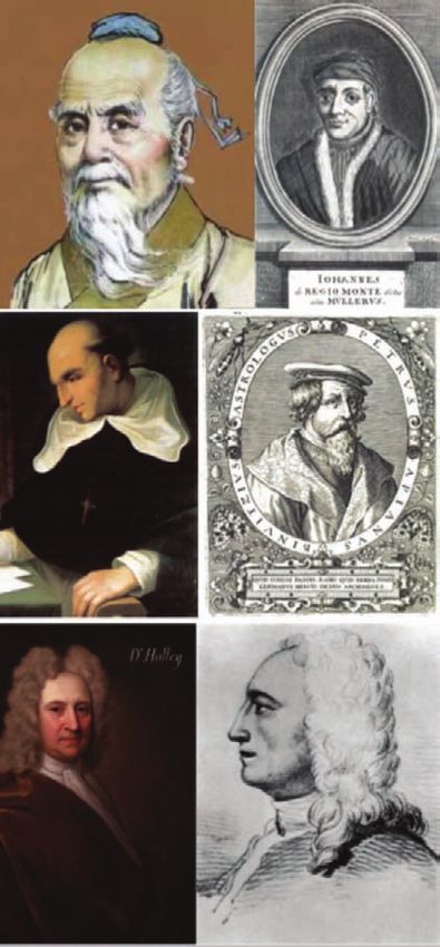
Pickering          (1997)
                                                                 suggests that Columbus may
                                                                 have been unsatisfied with the
                                                                 ‘short’ transatlantic distance he
                                                                 had recorded in his Diario. At a
                                                                 later stage, he proceeded to add
                                                                 the East–West distance he sailed
                                                                 within the Caribbean islands to
                                                                 the earlier total of 1142 leagues,
                                                                 which would have corresponded
                                                                 to at least 31 leagues from the
                                                                 Bahamas to Cuba (Pickering,
                                                                 1997), resulting in a total
                                                                 longitude difference with respect
                                                                 to Cádiz of 5 hours 31 minutes—
                                                                 similar to the difference he
                                                                 quoted in his Book of Prophecies
                                                                 (1501–1505).
Figure 2: Columbus on Jamaica during the lunar eclipse of 29          The numbers quoted in
February 1504. (Source: Flammarion, 1879: 231, Fig. 86; public
                                                               the Book of Prophecies are not
domain)
                                                               all internally consistent, however:
                                                               the       longitude       difference
Columbus reported for the second lunar eclipse he observed from Jamaica in February 1504
(see Figure 2) is 7 hours 15 minutes West of Cádiz. The correct, modern longitude difference
between both locations is 4 hours 44 minutes. In view of the fraudulent longitudes reported in
relation to the September 1494 eclipse, it may well be that Columbus proceeded along similar
lines here. In his July 1503 letter to the Spanish crown, he stated,

        When I set out thence to come to Española, the pilots believed that we were going to reach the
        island of San Juan [Puerto Rico], and it was the land of Mango [western Cuba], four hundred
        leagues more to the west than they said. (Jane, 1988: 98)

         The distance from San Juan Island to Mango is the longest East–West distance
Columbus recorded within the Caribbean archipelago. Added to the longest transatlantic
distance he recorded on his first voyage, 1142¼ leagues (re-determined by Pickering, 1997),
this yields a distance of 1542¼ leagues from Cádiz, corresponding to a difference of 7 hours
15 minutes in longitude—precisely the difference claimed by Columbus based on his
purported observations of the 1504 eclipse (for a different explanation, involving Columbus
having made a series of mistakes, see Olson, 1992).

2 FROM LUNAR ECLIPSES TO LUNAR DISTANCES

Lunar eclipses require close alignment of the Sun–Earth–Moon system. They occur only
occasionally and so cannot be relied upon for routine longitude determination at sea. Instead,
one could, in principle, use the projected position of the Moon with respect to a set of
reference stars—as we already saw in the context of early Chinese longitude determinations.

       This is the essence of the lunar distance method: given a sufficiently accurate
representation of the Moon’s path across the sky, one can calculate such lunar distances, or
‘lunars’, for any location on Earth and for specific times. At any other position, one can then
determine the local time(s) at which one or more specific lunars occur. The difference
between the tabulated time, in the sixteenth to nineteenth centuries most often that at
Greenwich Observatory, and the local time at the location of the observer—determined from
the altitude of the Sun, most often the Sun’s local meridian passage—can be converted
directly into a longitude difference. Although the principle of the lunar distance method is
straightforward, we will see shortly that its practical implementation is anything but (for the
method’s mathematical basis and practical implementations, see e.g. Inman, 1819; Merrifield,
1884; van der Werf, 1977; de Man, 2017).
It is generally thought that the lunar distance method’s first European publication can
be traced back to the German mathematician Johann(es) Werner’s In hoc opere haec
continentur Nova translatio primi libri geographiae Cl. Ptolomaei (Nuremberg, 1514), which
included a translation of Ptolemy’s Geographia. However, Werner may not have been alone
in pursuing longitude determination in the late Middle Ages. Around the time of his seminal
publication, Ferdinand Magellan was preparing for his round-the-world voyage of 1519–1522.
The explorer enlisted the services of the Spanish astronomer Andrés de San Martin (García
and del Carmen, 1997) as chief pilot of his fleet, the Armada del Maluco. The astronomer
brought with him Rui Faleiro’s set of instructions related to longitude determination collected
in Faleiro’s Regimento (Lopes de Castanheda, 1554: 161), which included a version of the
lunar distance method as one of three possible approaches to longitude determination
(Randles, 1984: 9).

       Randles (1984) has suggested that Faleiro may have drawn on a passage in the
Theori[c]a Planetarum, most likely attributed (Pedersen, 1981) to the thirteenth-century Italian
translator Gerard Cremonensis (also known as Gerard de Sabloneta),

      When the Moon is on the meridian, if you compare her position with that given in the lunar tables
      for some other locality, you may determine the difference in longitude between the place where
      you are and that for which the lunar tables were constructed by noting the differences in the
      position of the moon as actually observed and as recorded in the tables. It will not be necessary
      for you to wait for an eclipse. (Wright, 1922, transl.: 83–84)

       Using Faleiro’s proposed methods, de San Martin managed to accurately determine
the longitudes of both Puerto San Julián in Patagonia (southern Argentina) and Homonhon
Island in the eastern Philippines. It is likely that in doing so he relied predominantly on the
lunar distance method. At Puerto San Julián, he used the Moon’s conjunctions with the
planets to derive a position 61° West of Seville. The modern longitude difference between
both localities is 61.75°. This remarkably accurate longitude determination far exceeded that
of contemporary navigators (Joyner, 1992). Upon their arrival at Homonhon Island on 16
March 1521, de San Martin determined a longitude difference of 189° “from the meridian”,
that is, from the line of demarcation, 47° West of Greenwich. By modern standards,
Homonhon Island is located at 125° 43ʹ 47.3ʹʹ East. This implies that this 1521 longitude
determination was once again remarkably accurate, to within 2° of the current value.

        We will now return to Werner’s seminal work. He appears to have been inspired by a
letter from Amerigo Vespucci, the Italian explorer and Columbus’ cartographer, to his patron,
Lorenzo di Pierfrancesco de’Medici, referred to as ‘letter IV’ by Vespucci scholars. In that
letter, the Italian claimed to have determined his longitude based on observations of celestial
objects obtained on 23 August 1499 while on his second voyage in the Amazon river delta.

      Indeed, in a sixteenth-century copy of a fragmentary letter known as the Ridolfi
Fragment, discovered in 1937 by Professor Marques Ridolfi in the Conti archives (Conti de
Ottomano Freducci, Archivio di Stato, Firenze, Italy) and possibly dating from 1502, Vespucci
wrote to de’Medici,

      Briefly to support what I assert, and to defend myself from the talk of the malicious, I maintain
      that I learnt this [my longitude] by the eclipses and conjunctions of the Moon with the planets;
      and I have lost many nights of sleep in reconciling my calculations with the precepts of those
      sages who have devised the manuals and written of the movements, conjunctions, aspects, and
      eclipses of the two luminaries and of the wandering stars, such as the wise King Don Alfonso in
      his Tables, Johannes Regiomontanus in his Almanac, and Blanchinus, and the Jewish rabbi
      Zacuto in his Almanac, which is perpetual; and these were composed in different meridians: King
      Don Alfonso’s book in the meridian of Toledo, and Johannes Regiomontanus’ in that of Ferrara,
      and the other two in that of Salamanca. It is certain that I found myself, in a region that is not
      uninhabited but highly populated, 150 degrees west of the meridian of Alexandria, which is eight
      equinoctial hours. If some envious or malicious person does not believe this, let him come to me,
      that I may affirm this with calculations, authorities, and witnesses. And let that suffice with
      respect to longitude; for, if I were not so busy, I would send you full detail of all the many
      conjunctions which I observed, but I do not wish to become tangled in this matter, which strikes
      me to be the doubt of a literary man, and not one which you have raised. Let that suffice.
      (Vespucci, 1992: 38–39)

                                                                                                      7
Werner had carefully studied
                                                            Regiomontanus’               astronomical
                                                            treatises. His subsequent observations
                                                            of the orbital motion of a comet from 1
                                                            to 24 June 1500 laid the basis for what
                                                            we now know as the lunar distance
                                                            method. Although an ordained priest
                                                            (vicar) at Nuremberg since 1497, “his
                                                            pastoral duties were rather limited, [so]
                                                            he devoted much time to scientific
                                                            study” (Folkerts, 2020). Following
                                                            Regiomontanus’ teachings, his 1514
                                                            manuscript        discusses      longitude
                                                            determination on the basis of both
                                                            lunar eclipses and the Moon’s position
                                                            relative to the fixed stars or the Sun:

                                                            Our aim is to find the distance in longitude
                                                            between     two     distant  places.     The
                                                            geographer will be in one of these places
                                                            and will measure with a cross-staff [as
                                                            already used for latitude determination at
                                                            the time] the distance of the Moon from a
                                                            star on the Ecliptic [Earth’s equatorial
                                                            plane with respect to its orbital plane]. If
                                                            then we divide this distance by the velocity
                                                            of the Moon per hour, we will know at what
                                                            time in the future the Moon will be in
                                                            conjunction with this body. (Werner, 1514)

                                                                     Unfortunately, however, during
                                                              Werner’s     lifetime   the     celestial
Figure 3: Illustrations from (top) the title page of Apianus’
                                                              ephemerides        were    known       to
Introductio Geographica (Ingolstadt, 1533; public domain),
and (bottom) a folio from the Cosmographia Petri Apiani       insufficient precision  to   allow  this
(1524; public domain), both showing the lunar distance method to work. Werner’s method was
method in practice. Note the cross staffs employed by all discussed at length by Petrus
observers.                                                    Apianus, the German humanist and
                                                              mathematician. Apianus is perhaps
best known for his ‘volvelles’ or wheel charts, also known as ‘Apian wheels’, an early form of
analogue computers composed of rotating paper parts. He was clearly enamoured by
Werner’s lunar distance method (e.g., Gislén, 2018, 2019). He even illustrated the method on
the title page of his Introductio Geographica (Ingolstadt, 1533): see Figure 3. Apianus’ first
major work, Cosmographia seu descriptio totius orbis (Landshut, 1524), was the pre-eminent
sixteenth-century textbook for basic astronomy, surveying and cartography. Subsequent
editions were improved and expanded by Jemme Reinierszoon, the Professor of Medicine at
the University of Leuven better known as Gemma Frisius. The latter added numerous
appendices to the Cosmographia, including one outlining the use of clocks for determining
one’s longitude (Pogo, 1935).

       Apianus’ lunar distance method employed the cross staff (see Figure 4). However,
although useful for measuring latitudes, at the time the accuracy of the cross staff was
insufficient for use with the lunar distance method. One needed better lunar almanac tables
and the development of the octant. This latter development took until the early 1730s to
mature, with the (reflecting) octant’s first practical implementation by the English
mathematician John Hadley (aided by his brother George) and Thomas Godfrey, an inventor
based in the American colonies. The octant became the instrument of choice for navigation at
sea by the 1750s:

       The Instrument is design’d to be of Use, where the Motion of the Objects, or any Circumstance
       occasioning an Unsteadiness in the common Instruments, renders the Observations difficult or
       uncertain. (Hadley, 1731: 147; see also Figure 5)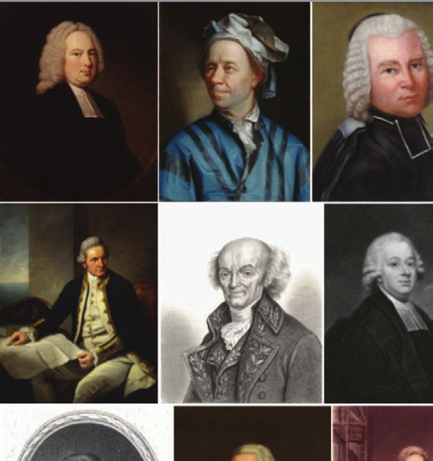
Independently from Werner and
                                                         Apianus, in 1634 the French
                                                         mathematician and astronomer Jean-
                                                         Baptiste Morin claimed that he had
                                                         discovered a new way of finding
                                                         longitude, commenting that, “I do not
                                                         know if the Devil will succeed in
                                                         making a longitude timekeeper but it
                                                         is folly for man to try” (Marguet, 1917:
                                                         7). Cardinal Richelieu, King Louis
                                                         XIII’s chief minister, established a
                                                         commission to examine this claim, the
                                                         Conférence           des       longitudes
                                                         (Bigourdan, 1916; Pares, 1977). The
                                                         body was composed of Henri-Auguste
                                                         de Loménie, Count of Brienne, other
                                                         government officials, naval officers
                                                         and mathematicians, including Blaise
                                                         Pascal’s      father     Étienne,    later
                                                         treasurer of France, Pierre Hérigone,
                                                         Claude Mydorge, Jean de Beaugrand
                                                         and Jean Boulenger. They concluded
                                                         that Morin’s approach, which was
                                                         based on measuring absolute time by
                                                         determining the position of the Moon
                                                         relative to the stars and which took
                                                         into account atmospheric refraction as
                                                         well as the lunar parallax (small
                                                         positional shifts depending on the
                                                         observer’s location), was simply a
                                                         more sophisticated version of the
                                                         common lunar distance method
                                                         (Bigourdan, 1916).

                                                                    Meanwhile,    in  the    early
                                                             seventeenth century proposals for the
                                                             development of viable methods of
Figure 4: Application of the cross staff (Jacob’s staff) for longitude determination at sea were
angular measurements between celestial objects (woodcut, actively considered by the Spanish
seventeenth century). Other geometric measurement Conseja de Indias (e.g., de Grijs,
instruments are shown on the ground in larger-than-natural 2020). In 1567, King Philip II
size. On the left, a different type of cross staff is shown. announced a significant monetary
(Credit: Wellcome Collection. Attribution 4.0 International; reward for anyone who could solve
CC BY 4.0)
                                                             the intractable longitude problem.
Upon his accession to the Spanish throne in 1598, King Philip III followed his father’s lead by
sponsoring a significantly more generous longitude prize.

       Hoping for a share of this Spanish longitude prize, the Flemish cartographer and
astronomer Michael Florent van Langren, seconded as cosmographer and mathematician to
the Spanish court, pursued a method of longitude determination based on the appearance
and disappearance of lunar features, particularly of the rising and setting of peaks and
craters. He realised that as the lunar phases progress from new to full moon, the Sun
progressively illuminates different lunar features from East to West, and vice versa from full to
new moon. In 1625 he presented his method as a possible solution to the longitude problem
to princess Isabella Clara Eugenia, daughter of Phillip II (Navarro Brotons, 2018; de Grijs,
2020). Despite initial royal encouragement (de Grijs, 2020), van Langren’s approach
ultimately failed, most importantly because lunar features appear gradually rather than
instantaneously.
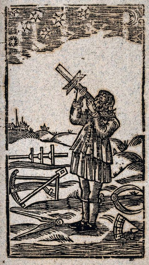
Figure 5: (left) Mural quadrant (‘Fig. 3’); (right) Hadley’s sextant (‘Fig. 4’). Engraving (detail). (Credit:
Wellcome Collection. Attribution 4.0 International; CC BY 4.0)

        Around the same time, the Spanish philosopher and mathematician Juan Caramuel y
Lobkowitz presented an altogether novel and systematic approach to longitude determination
based on lunar positions. In 1625, had Caramuel joined the Cistercian Order at the Monastery
of La Espina (García Camarero, 2018) under the patronage of Pedro de Ureña. Although he
was blind, de Ureña had independently devised his own version of the lunar distance method,
but he passed away before he managed to get his method published (Sanhuesa Fonseca,
1999; de Barcelos e Coles, 2014). He left the printing and dissemination of his invention to
Caramuel (Velarde Lombraña, 1982: 505; for an in-depth discussion, see de Grijs, 2020).

        Tabulated lunar distances reflect the Moon’s position as it would be seen by a
geocentric observer, that is, an observer located at the centre of the Earth. One must
therefore correct for the observer’s location on the Earth’s surface, which may require an
angular shift of up to a degree. In practice, a shipboard observer would measure the
                                                                        3
projected angular distance between the Moon’s sharp limb and his selected reference object
using a sextant or an octant. He would then need to correct the observed separation as well
as the Moon’s altitude for the projected size of the Moon on the date of the observation
(Dunlop and Schufeldt, 1972: 409), a quantity tabulated in contemporary almanacs. The
combined correction for atmospheric refraction and lunar parallax—usually also provided in
tabular form—is a relatively straightforward trigonometric function involving the observed
lunar distance and the respective altitudes of the Moon and the reference star(s) (Van
Flandern and Pulkkinen, 1979; see also Schlyter, n.d.), for which navigators would usually
use pre-calculated mathematical tables. This process is known as ‘clearing’ lunar distances.
The objects’ altitudes should be measured both before and after measuring the lunar distance
itself or, if possible, simultaneously (Stark, 2010; x–xiii). Finally, the observer would consult
his almanac again to read off the exact time at Greenwich Observatory implied by the
measured lunar distance. Combined with his local time, independently obtained from
observations of the Sun or bright references stars crossing the local meridian, this would then
result in an operational longitude determination.

       Despite this apparently straightforward approach, Morin and the Conférence des
longitudes were in dispute about the new method’s feasibility until 1639, given that ephemeris
tables of the requisite accuracy were as yet non-existent. During this period, Morin proposed
to establish an observatory in Paris (Delambre, 1821: 242; see Figure 6) to obtain regular
observations of the positions of the Moon and selected reference stars for the dual purposes
of longitude determination and cartographic corrections (Wolf, 1902: 2). Paris Observatory
was eventually established in 1667, although Morin’s influence in getting the project off the
ground is unclear (Deias, 2017).
Meanwhile, Richelieu died in 1642. In
1645, his successor, Cardinal Jules
Raymond Mazarin, gave Morin 2000
livres for his efforts, but his proposed
method was still deemed impractical.
In 1674, a French explorer
calling himself Le Sieur de Saint-Pierre,
most likely Jean-Paul Le Gardeur (de
Grijs, 2017: Ch. 6), claimed to have
solved the longitude problem based on
application of the lunar distance method
(Forbes, 1976). Meanwhile, in England,
King Charles II had been receiving ever
increasing numbers of proposals from
scholars and opportunists alike claiming
to have solved the longitude problem.
This development prompted him to
appoint a Longitude Commission to
validate these proposals,
… that he [de Saint-Pierre] hath found out
the true knowledge of the Longitude, and
Figure 6: Detail of the fixed observation structure desires to be put on Tryall thereof; Wee
proposed by Jean-Baptiste Morin (Morin, 1634, Ch. IX, p. having taken the Same into Our
355; Bibl. Nat., V-18023; public domain). consideration, and being willing to give all
fitting encouragement to an Undertaking soe
beneficiall to the Publick … hereby doe constitute and appoint you [the Commissioners], or any
four of you, to meet together … And You are to call to your assistance such Persons, as You
shall think fit: And Our pleasure is that when you have had sufficient Tryalls of his Skill in this
matter of finding out the true Longitude from such observations, as You shall have made and
given him, that you make Report thereof together with your opinions there-upon, how farre it
4
may be Practicable and usefull to the Publick.
On 4 March 1675, the King signed a royal warrant to appoint John Flamsteed as “our
astronomical observator" and assistant to the Royal Commission. He proceeded to undertake
an observational programme to test the viability of de Saint-Pierre’s proposal. Although he
acknowledged the method’s potential, Flamsteed also highlighted its practical infeasibility
given the lack of detailed tables of the positions of the fixed stars relative to both the Sun’s
annual path and the Moon’s orbital parameters.
Meanwhile, while compiling the first edition of his Philosophiæ Naturalis Principia
Mathematica (London, 1687), Isaac Newton (1687: 434) hoped to use the Moon’s path across
the sky for longitude determination at sea in an attempt to combine the best aspects of
astronomy and accurate timekeeping. Newton understood that the success of the lunar
distance method depended on an accurate understanding of the lunar motions. These are
fairly complex, however, given that the Moon’s orbit is determined by three-body gravitational
interactions among the Sun, the Earth and the Moon. Large numbers of careful and precise
observations of the Moon’s motion relative to the fixed stars are required to accurately trace
its movement across the sky. The global pattern, driven by precession of the lunar orbit
relative to the ecliptic plane, repeats only once every 18.6 years while also exhibiting
repeating minor perturbations and fluctuations, together posing a major problem for Newton
and his contemporaries (Smith, 1999).
As we will shortly see, despite the significant efforts he undertook in preparation for the
three editions of his Principia, Newton did not manage to obtain a satisfactory solution to the
problem. He continued to refine his treatment of the lunar motion and its application to
longitude determination until the publication of the Principia’s second edition (Newton, 1713;
Cook, 2000). Although Newton had apparently already invented an innovative reflecting
octant around 1699, which was meant to measure distances between the Moon and starswhile at sea, and hence to help him in his modeling efforts, a description of the instrument
(Newton, 1699) was only found among the papers of Edmond Halley, Britain’s second
Astronomer Royal, long after Newton’s (and Halley’s) death:
By this instrument the distance of the moon from any fixed star is thus observed; view the star
through the perspicil [telescope eyepiece] by the direct light, and the moon by the reflexed, (or on
the contrary;) and turn the index till the star touch the limb of the moon, and the index shall show
on the brass limb of the instrument the distance of the star from the moon's limb; and though the
5
instrument shake by the motion of the ship at sea, yet the moon and star will move together as if
they did really touch one another in the heavens; so that an observation may be made as exactly
at sea as at land. And by the same instrument, may be observed exactly the altitudes of the
moon and stars, by bringing them to the horizon; and thereby the latitude and times of
observation may be determined more exactly than by the ways now in use. (Newton, 1742)
3 FLAMSTEED’S MURAL ARC
Flamsteed realised that he would need years of observational data, obtained with large
instruments fitted with telescopic sights, to make the lunar distance method a practical reality.
On 11 September 1689, he inaugurated a new mural arc at Greenwich Observatory, allowing
for more precise observations. His first task following verification of the arc’s position and
calibration of its performance was to determine the equinox, that is, the date on which day
and night are approximately equally long anywhere on Earth, the Observatory’s latitude, the
obliquity (inclination) of the Earth’s ecliptic plane and other fundamental measurements
required to correctly determine the positions of the fixed stars.
Flamsteed also determined true solar, lunar and planetary motions. Newton was keen
to use these as the basis of his lunar distance method, but it took a number of years before
Flamsteed was prepared to make his results public. Flamsteed’s mural arc, used alongside
an accurate pendulum clock, allowed him to measure zenith distances of objects crossing the
local meridian, as well as the exact sidereal times when this happened. In turn, these
measurements enabled him to calculate the objects’ right ascensions and declinations, that
is, their accurate positions on the sky.
It is clear that Newton was struggling to make sense of the observations he had access
to. Ultimately, Newton’s failure to solve the complex Sun–Earth–Moon three-body problem led
to a significantly deteriorated relationship with Flamsteed, whom Newton accused of
ineptitude. Nevertheless, one should keep in mind that Newton was the first to attempt to
solve the three-body system’s equations of motion, and that his results were nevertheless
remarkably successful. The three-body problem was eventually solved numerically by the
6
Swiss polymath Leonhard Euler, who received a reward of £300 from the British Board of
Longitude (see below) in May 1765 “for Theorems furnished by him to assist Professor
[Tobias] Mayer in the Construction of Lunar tables”. (Howse, 1998: 408). I will shortly discuss
Mayer’s contributions (see Section 4).
The full body of Flamsteed’s observations was eventually published posthumously in
the second volume of his Historia Coelestis Britannica (1725), edited by his wife Margaret.
During his lifetime, he had put off publishing his observations until completed, despite being
pressured to do so by, among others, Newton and Halley. Around 1683, Halley actually
contributed observations of occasional lunar occultations (eclipses) of some bright stars, as
well as their ‘appulses’ (close encounters on the sky). He had hoped to use these
measurements as accurate timing devices (Halley, 1731), that is,
… he had found it needed only a little practice to be able to manage a five or six foot telescope
capable of shewing the appulses or occultations of the fixed stars by the moon on ship-board in
moderate weather, especially in the first and last quarter of the moon’s age, when her weaker
light does not so much efface that of the stars … Now the motion of the moon being so swift as
to afford us scarce ever less than two minutes for each degree of longitude, and sometimes
two and a half, it is evident that we were able perfectly to predict the true time of the appulse or
occultation of a fixed star in any known meridian, we might, by comparing therewith the time
observed onboard a ship at sea, conclude safely how much the ship is to the eastward or
westward of the meridian of our calculus. … [but] the best tables then extant [in 1715] were too
imperfect for this purpose; but that the errors of the tables returning to pretty near the same
12quantity after a period of 18 years and 11 days, or 223 lunations, the tables might be corrected
at any time from observations made at that distance of time in an antecedent period, provided
such were made. (Mayer, 1771)
Unfortunately, the occultation method turned out to be too cumbersome for practical
7
application given the scarcity of bright stars and their infrequent lunar occultations. It was
deemed impractical to train maritime navigators to recognise a useful set of dimmer stars.
The three volumes of Flamsteed’s Historia Coelestis contained more than 28,000
observations made with the mural arc between 11 September 1689 and 27 December 1719,
which provided 2935 stellar positions more accurately than published in any previous
compilation. Although the catalogue was not entirely free of errors, the tabulated stellar, lunar
and planetary positions were sufficiently accurate to make the lunar distance method a viable
8
navigation approach. However, one still needed to correct the motions of the Sun and the
Moon and somehow measure the Moon’s position with respect to the fixed stars while at sea.
Meanwhile, in the first edition of his Principia (Book I, Proposition LXVI; Book III),
Newton had discussed the Moon’s motion in general terms, concluding that understanding
the effects of the Sun’s gravity was paramount. He expressed the Sun’s gravitational pull as a
perturbation in the Moon’s Earth-centred acceleration. His treatise from 1702 aided him in
improving his description of the Moon’s motion, published in the Principia’s second edition
(1712). The description in the third edition was largely consistent with that published in the
previous edition, although Newton included an explanatory addendum by Machin (1726)
detailing the motion of the Moon’s orbital nodes (Cook, 2000). At the same time, Flamsteed
had used Newton’s insights from 1702 to prepare a set of tables that included some lunar
observations; however, these were not published until 1746, posthumously, and only in
France (Le Monnier, 1746: 251).
Separately, Halley had played an important role in firming up the observational basis of
Newton’s lunar orbital theory. By 1719, he had prepared—but did not publish—a large
number of observational tables pertaining to a range of celestial bodies, including the Moon,
representing Newton’s version of his theory as published in the Principia’s second edition.
Between 1721 and 1739, Halley obtained numerous detailed observations of the Moon.
Again, however, he did not publish his observational data, although halfway through his 18-
year observation cycle, in 1731, he offered some early insights into the accuracy of Newton’s
theory (Halley, 1731). Halley suggested that the Moon’s positions as predicted by Newton’s
theory agreed with his own observations to within 2 arcmin (standard deviation, with outliers
of up to 8 arcmin) of projected separation (Cook, 2000), and that his own observations agreed
well with those of Flamsteed and others, which had been obtained several lunar cycles
previously. Halley’s full tables were eventually published posthumously (Halley, 1749, 1752).
Meanwhile, on 9 July 1714 Queen Anne had given her royal assent to An Act for
providing a Public Reward for such Person or Persons as shall discover the Longitude at Sea.
As a result, 22 ‘Commissioners for the Discovery of the Longitude at Sea’, popularly known
as the ‘Board of Longitude’, were initially appointed to adjudicate claims. The British
Longitude Act included a reward of up to £2000 for work that appeared promising and
£10,000 for a demonstrably practical method that was successful in determining one’s
longitude at sea with an accuracy down to one degree of a great circle, equivalent to 60
nautical miles at the Equator. The monetary reward would be increased to £15,000 for
accuracies of 40 arcmin and to £20,000 for methods with an accuracy of half a degree or
better.
The Longitude Act did not include a role for an actual Board of Longitude nor any
formal procedure for submitting proposals or demonstrations. All interested parties were
expected to contact the Commissioners or the Admiralty through published pamphlets,
broadsheets or newspapers, by sending letters or in person. (The de facto Board of Longitude
did not meet in person until 1737; Baker, 2015.) The Queen’s endorsement of the 1714
Longitude Act led to a flurry of activity, generating numerous proposals from genuine
scientist-scholars, lunatics and those hoping to become wealthy easily.
13The increasing importance of Flamsteed’s observations, combined with the frenzied
activity triggered by the passing of the Longitude Act, led Robert Wright to prepare his
Viaticum Nautarum (Sailor’s Vade Mecum; Wright, 1726, 1732). Wright (1726) emphasised
the need for a practical quadrant and included images of such an instrument, a full nine years
prior to the development of Hadley’s reflecting octant. His follow-up submission of 1732
included lunar tables required to “make a complete System of all that is yet wanting in
Navigation”. Yet, despite his careful preparation, the Commissioners of the Board of
Longitude seem to have ignored his submission:
I hope I may be permitted to say without boasting, that I cannot think this so petty, trivial, jejeune,
and insignificant a Performance, that it ought to be thrown a-side unregarded, and buried in
Silence. (Barrett, 2013)
4 LARGE-SCALE PRACTICAL APPLICATIONS
It took until the 1750s before sufficiently accurate lunar tables became available for large-
scale practical use. While employed at the Göttingen University Observatory, the German
astronomer Tobias Mayer was instrumental in developing improved lunar and solar
ephemeris tables (Forbes, 1971). Mayer was once referred to by Euler as “undoubtedly the
greatest astronomer in Europe”, while the French astronomer Jean Delambre heaped even
more lavish praise on the cartographer, referring to him as “universally considered … one of
the greatest astronomers not only of the eighteenth century, but of all times and of all
countries” (Delambre, 1827).
In 1752, Mayer designed a novel ‘repeating circle’, allowing him to obtain more
accurate measurements, as we learn from the Spanish astronomer José de Mendoza y Ríos
(1801):
As the reflecting instruments employed at sea are supported by hand, their weight and scale
are limited within a narrow compass; and it seemed very difficult to obviate, by any expedient,
the inconveniences arising from the smallness of their size, while it was impossible to increase
it. The celebrated Tobias Mayer contrived, however, a method to determine, at one reading,
instead of the simple angle observed, a multiple of the same angle; and, by this means, the
instrument became, in practice, capable of any degree of accuracy, as far as regards the
above mentioned errors. His invention is essentially different from the mere repetition of the
observations ...
From 1753, he employed his novel instrument to improve and further develop the
lunar and solar ephemeris tables he needed to obtain better longitude determinations in
support of his cartographic work. (After 1778, Mayer’s repeating circle was perfected by the
French astronomer Jean-Charles de Borda, whom we will encounter shortly.) However,
Mayer was reluctant to submit his work to the British Board of Longitude since he did not
believe the Board would award its Longitude Prize to a foreigner. Nevertheless, in 1757 he
was eventually convinced to submit an amended set of lunar tables. His tables were sufficient
to determine longitude at sea to better than half a degree, as noted by Nevil Maskelyne, the
fifth British Astronomer Royal, in The British Mariner’s Guide (1763):
The Tables of the Moon had been brought by the late Professor Mayer of Göttingen to a
sufficient exactness to determine the Longitude at Sea to within a Degree, as appeared by the
Trials of several Persons who made use of them. The Difficulty and Length of the necessary
Calculations seemed the only Obstacles to hinder them from becoming of general Use.
In 1760, while writing a preface to his tables, Mayer had commented,
I am the more unwilling my tables should lie any longer concealed; especially as the most
celebrated astronomers of almost every age have ardently wished for a perfect theory of the
Moon ... on account of its singular use in navigation. I have constructed these tables ... with
respect to the inequalities of motions, from that famous theory of the great Newton, which that
eminent mathematician Eulerus first elegantly reduced to general analytic equations.
(O’Connor and Robertson, 2008)
14Yet it took until 1767 before his tables and the underlying theory (Theoria lunae juxta
systema Newtonianum) were published, well after his death. Meanwhile, James Bradley,
Britain’s third Astronomer Royal, had carefully checked Mayer’s tables. In his first letter to the
Secretary of the Admiralty, of 10 February 1756, the Astronomer Royal wrote
… that he had carefully examined Mr. Professor Mayer’s theory and tables of the moon’s
motions, and other papers relating to the method of finding the longitude at sea, and compared
several observations made (during the last five years) at the Royal Observatory at Greenwich,
with the places of the moon computed by the said tables; and in more than 230 comparisons,
which I have already made, I did not find any difference so great as 1ʹ½ between the observed
longitude of the moon and that which I computed by the tables: and although the greatest
difference which occurred is, in fact, but a small quantity; yet as it ought to be considered as
arising partly from the error of the tables, it seems probable, that during this interval of time, the
tables generally gave the moon’s place true within one minute of a degree. A more general
comparison may, perhaps, discover larger errors; but those which I have hitherto met with
being so small, that even the biggest could occasion an error of but little more than half a
degree in longitude, it may be hoped, that the tables of the moon’s motions are exact enough
for the purpose of finding at sea the longitude of a ship, provided that the observations that are
necessary to be made on ship-board can be taken with sufficient exactness. The method of
finding the longitude of a ship at sea by the moon, hath been often proposed, but the defects of
the lunar tables have hitherto rendered it so very imperfect and precarious, that few persons
have attempted to put it in practice; but those defects being now in great measure removed, it
may well deserve the attention of my Lords Commissioners of the Admiralty (as also of the
Board of Longitude) to consider what other obstacles yet remain, and what trials and
experiments may be proper to be made on ship-board, in order to enable them to judge
whether observations for this purpose can be taken at sea with the desired accuracy. (Mayer,
1771; Rigaud, 1831: 84–85)
In a follow-up letter, dated 14 April 1760, he attested to the success of the method’s
application at sea:
I computed the ship’s longitude from each of the observations made by captain Campbell, and,
upon comparing the results of several that were taken near the same time, and under the like
circumstances, it appeared, that in general the observer was not liable to err more than one
minute in judging of the apparent contact of the moon’s limb and the object with which it was
compared. Now this being nearly the same error that would be found to obtain if the like
observations were to be made with the same instruments on land, it may hence be inferred,
that in moderate weather the motion of the ship is not otherwise an impediment in this sort of
observations, than as it renders the repetition of them more tedious and troublesome to the
observer, which yet ought by no means to be omitted; because if each single observation be
liable to an error of a minute only, by taking the mean of five or six, the error on this head may
be so far diminished as to be of small moment. (Mayer, 1771; Rigaud, 1831: 86–88)
Shortly afterwards, Maskelyne used the tables on his voyages to St. Helena in 1761
and Barbados in 1763. The fact that he became a lifelong convert to the use of the lunar
distance method following these voyages speaks for itself. In fact, in a memorandum to the
Commissioners of the Board of Longitude of 9 February 1765, Maskelyne argued
… that the longitude deduced from observations made by himself and others, with the help of
Mr. Mayer’s printed tables, always came within a degree; but as I am informed that Mayer’s
last manuscript tables are much more exact than the printed ones, it may be presumed that the
longitude deduced from them will come considerably within a degree. (Mayer, 1771)
At Maskelyne’s request, several experienced mariners attended the Board’s next
meeting, providing supporting evidence in the form of their journals and other documents,
… that they had determined the longitude of their respective ships, from time to time, by
observations of the moon, taken in the manner directed by the aforesaid book, and found the
said observations easily and exactly to be made, and that the longitude resulting always
agreed with the making of land (near the time of making the observations) to one degree; that
they could make the observations in a few hours, not exceeding four hours, and are of opinion,
that of a Nautical Ephemeris was published, this method might be easily and generally
practised by seamen. (Mayer, 1771)
15You can also read