A Study of the Ablution Wastewater Conservation at Al Baythar Mosque in the Banjarbaru City, Indonesia
←
→
Page content transcription
If your browser does not render page correctly, please read the page content below
Timor-Leste Journal of Engineering and Science
 Vol.2, Issue.1, pp.1-10, 2021
 Available online at: http://tljes.org/index.php/tljes/data

A Study of the Ablution Wastewater Conservation at Al Baythar Mosque in the
Banjarbaru City, Indonesia
Nurfansyah Nurfansyah1, Ulfa Fitriati2, Novitasari Novitasari2*
1Department of Architecture of Lambung Mangkurat University, Indonesia
2Department of Civil Engineering, of Lambung Mangkurat University, Indonesia
Email: nfsarsitek@ulm.ac.id, ufitriati@ulm.ac.id, novitasari@ulm.ac.id (*Corresponding author)

ABSTRACT

The City of Banjarbaru, based on the attachment of existing RAKH, the current conditions, the area of Banjarbaru City Green Open Space is +
2,638.83 Ha or 8.213% of the Banjarbaru City area, which consists of public green open space and private green open space. In contrast, the
minimum green open space (RTH) is 30% of the city area. It is the trigger for flooding in Banjarbaru City. The aim of this research is to the
evaluation of the infiltration well for ablution wastewater in a public building. This monitoring includes water table monitoring from the pump
wells around the infiltration well. The future impact will reduce the volume of floods that occur in Banjarbaru City. This study used a mosque
as a pilot site to apply infiltration well design built-in 2014. The mosque, in this case, is not only burdened by rainwater but also from water used
for ablution, which has been released into road drainage channels. After five years of infiltration well was build the condition of the water table
around can be maintained. It is evidenced by the absence of additional depth of pump wells around the infiltration well.

Keywords: ablution wastewater, infiltration well, mosque, and Banjarbaru city

Received August 10, 2021; Revised September 29, 2021; Accepted November 04, 2021

1. Introduction City because the water table level is adequate for
 constructing infiltration wells. This solution has also been
 The land cover increase is one of the causes of flooding stated in one of the regional regulations owned by the City
due to lack of water infiltration into the ground other than of Banjarbaru, namely the Regional Regulation of the City
rainfall (Wesli et al., 2013). Implementation of Undang- of Banjarbaru, number 05 of 2000, concerning the
undang Republik Indonesia No. 26 of 2007 concerning Implementation and Tax Utilization of Groundwater and
Spatial Planning (UU RI No. 26, 2007). In this law, the Surface Water in chapter IV control, section 19 subsection
minimum green open space (RTH) is 30% of the city area. three. The content of the regulation is that for every 5 (five)
The minimum of public city green open space is 20% of the drilled wells in one location owned or for every underground
city area, and the rest is private green open space, which water extraction with a water discharge of more than 50
depends on the population in a city. (fifty) liters per second or in certain places where the water
 The City of Banjarbaru, based on the attachment of condition is considered vulnerable; the permit holder is
existing RAKH, the current conditions, the area of required to provide 1 (one) special drilled well to monitor
Banjarbaru City Green Open Space is + 2,638.83 Ha or environmental changes as a result of groundwater extraction
8.213% of the Banjarbaru City area, which consists of public in the vicinity and construct 5 (five) rainwater infiltration
green open space and private green open space. Public green wells to help restore water resources (Peraturan Daerah No
open space is 2,350.40 hectares or 7,315% of the total area 5, 2000).
of Banjarbaru City (Bappeda, 2016). It means that the The infiltration well technology is one of the rainwater
city/public and private green open space does not reach the harvests in urban and rural areas (Tamelan and Kapa, 2020).
minimum value stipulated in the law. The construction of One of the constructions of infiltration wells in urban and
private and public buildings without supervision will give public facilities is carried out in the ITB Bandung campus to
the community the freedom to cover all the land they own reduce surface runoff with an impermeable surface balance
with the pavement. It does not support the drainage of (Mardiah et al., 2018). The other academic’s community
rainwater to infiltration into the ground. When there is high- service with assistance and development of the infiltration
intensity rainfall, water will accumulate on the ground wells in Tlogomas Village, Lowokwaru District, Malang
surface without entering the land. It is the trigger for flooding City to subtract the flood (Hirijanto, Mundra and
in Banjarbaru City at this time. Wedyantadji, 2021; Prayitno et al., 2021). In the same study
 One of the best ways to store groundwater in the rainy area, there are many research development in infiltration
season is to build an infiltration wells system (Bahunta and technic to reduce floods or inundation. Research on
Waspodo, 2019). This system can be applied in Banjarbaru

 1
Timor-Leste Journal of Engineering and Science Vol.2, Issue.1, pp.1-10, 2021 Available online at: http://tljes.org/index.php/tljes/data infiltration wells in the Banjarbaru City area, especially in Q = inlet water discharge (m3/s) the ULM Campus, is being implemented because the F = the shape factor (m) existing groundwater level ranges from 7 to 18 m K = hydraulic conductivity (m/s) (Fachrurazie, Firman Arifin and Sri Susanti, 2002). Maulana T = flow duration (s) also developed a similar study by calculating the required R = well radius (m) budget for wells in the ULM (Isramaulana, 2016). This research aims to evaluate the infiltration well for The shape factor is a quantity that represents the ablution wastewater in a public building. This monitoring circumference and cross-sectional area of the well, the includes water table monitoring from pump wells around the hydraulic gradient, the state of the soil layer and the position infiltration well. In this case, the public facility that will be of the well against the layer, and the porosity of the suitable used as a model in this service is the mosque (Suratkon, Chan wall, which is expressed in terms of the radius of the well and Tuan Ab Rahman, 2014). The mosque is one of the (Sunjoto, 2016a). It is shown in Table 1. public facilities which is the center of religious and social activities, which is very appropriate to be used as a pilot Table 1. Shape Factor for Flat Bottom facility for the implementation of the infiltration well system for the community. The mosque was chosen as a pilot site Condition Shape Factor because the mosque received a load from rainwater and received a load from the water used for ablution, which had been released into the drainage channel. The Al Baythar Mosque was chosen, which is located in the Lambung Mangkurat University area. It is a public facility used by the community around the campus. Banjarbaru City, in general, has a fairly deep groundwater table (≥5 meters). In this mosque was built an infiltration well in 2014. So it can be used as one evaluation monitoring of the performance of infiltration well after five years. 2. Literature Review 2.1. Infiltration Well System Water resources management and protection are critical given the increased water use, one of which is preserving groundwater with infiltration wells (IKA, 2007). A recharged system or infiltration system is a technical building that is planned to absorb rainwater (surface runoff) into the ground, which consists of three types, namely infiltration well, infiltration trench, and infiltration yard (Sunjoto, 2016b). Infiltration wells are water conservation that is commonly made as an individual (Kimpraswil, 2000). Infiltration well is also effective in reducing the local excess runoff (Mardiah et al., 2018). The primary purpose of infiltration wells is to increase water entry into the soil aquifer as infiltration water. Infiltration Well Design Theoretically, according to (Sunjoto Sunjoto. 1994), the volume and efficiency of infiltration The methods concepts are fitted to probability concepts. wells can be calculated based on the water balance of SNI T-02-02-2006 states that the local drainage system entering the water to the well and infiltration into the ground. design is based on a five years return period (PU, 2006). They can be written as follows (Sunjoto, 2016b): 2.2. Infiltration and Soil Permeability Q − FKT H= 1 − exp R 2 Permeability is the ability of the soil to release water. Soil FK with high permeability can increase the infiltration rate, with, thereby reducing the water flow rate. Soil permeability can H = water depth in the well (m) be tested with a constant head (Sunjoto, 2016a). Permeability is affected by void ratio, grain size, temperature and 2
Timor-Leste Journal of Engineering and Science Vol.2, Issue.1, pp.1-10, 2021 Available online at: http://tljes.org/index.php/tljes/data structure, and stratification. Lower permeability correlated The empirical formula is used to convert the daily with the size of grain and void ratio. rainfall intensity to the rainfall intensity with a shorter duration, which can be written in the following equation: ( ) 2.3. Hydrology Analysis R24 24 2 3 The maximum rainfall frequency analysis is intended to I= 24 tc predict the maximum amount of rainfall with a specific with, return period, which will later be used for calculating the I = rainfall intensity (mm/hour) design discharge using the empirical method. The equation R24 = daily maximum rainfall in 24 hours (mm/hour) for the calculation of the frequency analysis method used is Tc = time of concentration (hour) the Normal distribution method, the Log-normal distribution 6. Design discharge method, the Gumbel Frequency distribution method, and the The method to calculate the amount of design discharge Log-Pearson Type III distribution method (Chow, is the rational method. Mathematical equations are Maidment, and Mays, 1988; Suripin, 2004; Bambang expressed in the form: Triadmodjo, 2008). The hydrology analysis was conducted Q = 0.278·C·I·A \ based on the maximum daily precipitation with the rainfall- with, runoff method (Suripin, 2004). Q = design discharge (m³/s) 1. Determination of data series for analysis with annual C = runoff coefficient of the roof or pavement maximum series. I = rainfall intensity (mm/hour) 2. Determination of statistical parameters, such as mean, A = area of the roof or pavement (km²) standard deviation, variation coefficient, skewness 7. Ablution waste water discharge coefficient, and kurtosis coefficient (Bambang Ablution wastewater is water used after the cleaning Triadmodjo, 2008). process in Muslim worship (Suratkon, Chan and Tuan a. Mean Ab Rahman, 2014). At certain times, such as during 1 n worship hours, water entering through the inlet pipe is X = Xi certain to be very abundant, especially during mass n i =1 worship times such as Maghrib, Friday, and Taraweeh b. Standard deviation prayers. Also, in the seasons of Islamic holidays, such n as Maulid and others, the mosque is always filled with (X i − X )2 worshipers who are sure to consume a lot of water for S= i =1 ablution. (n − 1)) c. Variation coefficient 3. Research Methodology S 3.1. Data Cv = X The data collected in this research are from primary and d. Skewness coefficient secondary data. Rainfall data were collected as secondary n n collected data from bmkg online from the year 1993 to 2012 3 Cs = . ( X i − X )3 for infiltration well design (BMKG, 2012). The data was (n − 1)(n − 2).S i =1 collected for redesign using rainfall data from 1993 to 2020. e. kurtosis coefficient The rainfall accumulated as input for infiltration is well n2 n influenced by the C coefficient (runoff coefficient). C 4 Ck = . ( X i − X )4 coefficient for roof cover is about 0.75 to 0.95 (Suripin, (n − 1)(n − 2)(n − 3).S i =1 2004). with: The land use and the capacity of wastewater from n = number of data ablution as primarily collected data. Permeability coefficient Xi = rainfall data is held out by laboratory tests using the constant head method and direct measurements using a Double Ring Infiltrometer 3. To estimated distribution type as Normal distribution, in the field to be used to infiltration well analysis. Log-normal distribution, Gumbel distribution, and Log The amount of wastewater from ablution was collected Pearson III distribution. by direct observation in Al Baythar Mosque for one month. 4. The analysis of the suitability test used two statistical Especially during mass worship times such as Maghrib, methods, namely the Chi-Square test and the Smirnov- Friday, and Taraweeh prayers. Based on observation, Kolmogorov test. wastewater ablution is 0.004 m3 (Q0W) per congregant. 5. Rainfall Intensity QRW = QoW *max.congregants/tw 3
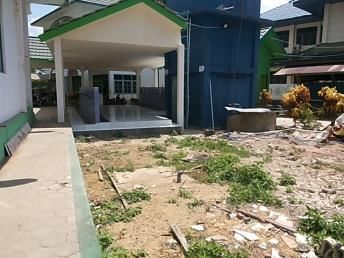
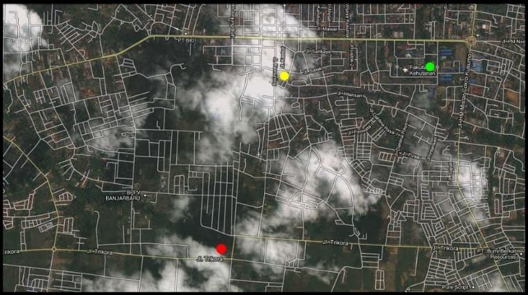
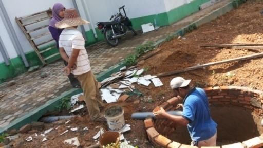
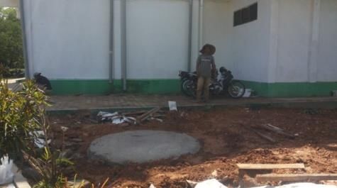
Timor-Leste Journal of Engineering and Science
 Vol.2, Issue.1, pp.1-10, 2021
 Available online at: http://tljes.org/index.php/tljes/data

 Tabel 2. Data on the Area of Mosques in Banjarbaru City
3.2. Study Area Area
 No Building Location
 This research is located in the Banjarbaru City, South (m²)
 Agung Al-Munawaroh
Kalimantan, Indonesia. Geographically, the Banjarbaru City 1
 mosque
 Jl. Trikora 4600
is located between 3º 25' 40"- 3º28'37'' South Latitude and Jami Hidayatul Muhajirin
 2 Jl. Manggis 1410
114º4'22''- 114º54'25'' East Longitude. The geographical mosque
position of Banjarbaru City is 35 km at 296°30' southeast of 3 Al-Baythar mosque Jl. A.Yani km.36 657
Banjarmasin City, which is the capital city of South Masjid Jami Sulaiman
 4 Jl. A. Yani km 21 625
 mosque
Kalimantan Province. 5 Nurul Muhajirin mosque Jl. A. Yani km 30,4 580
 The Banjarbaru City area is located at an altitude of 500 6 Istiqomah mosque Jl. A. Yani km 33,7 540
m above sea level, with an altitude of 0 – 7 m (33.49%), 7 – 7 Nur Jariyah mosque Jl. A. Yani km 30.5 529
25 m (48.46%), 25 – 100 m (15.15%), 100 – 250 m (2.55%) 8 Nurul Fallah mosque Jl. A.Yani km.36.5 456
and 250 – 500 m (0.35%). The slope classification of the 9 Darul Yaqin mosque Jl. A.Yani km. 20 440
Banjarbaru City is a slope of 0 – 2% covering 59.35% of the 10 Al-Ikhlas mosque Jl. Panglima Batur 400
 Kanzul Khairat mosque Jl. Panglima Batur
area, a slope of 2 – 8% covering 25.78% of the area, a slope 11
 Timur
 324
of 8 – 15% covering 12.08% of the area. The rocks 12 Darul Muttaqien mosque Jl. Kamboja 324
classification in the Banjarbaru City consists of Alluvium Jami Al-Mukarramah
 13 Jl. A. Yani km 25 309
48.44%. In the city of Banjarbaru, there are 3 (three) groups mosque
of soil types, namely Podzol soil (63.82%), Lathosol 14 Miftahul Khairat mosque Jl. A. Yani km 31.5 289
 15 Ishlah mosque Jl. RO Ulin 260
(6.36%), and Organosol (29.82%) (RPIJM, 2015). 16 Nurul Iman mosque Jl. A. Yani km 33.5 225
 The Banjarbaru land-use patterns are generally divided 17 Baitul Azhim mosque Jl. Bhayangkara 196
into two, namely developed areas and undeveloped areas.
The developed area in Banjarbaru consists of settlements, Al-Baythar Mosque was chosen as a pilot mosque
trade and services, education, health, worship, offices, because the mosque is located on the ULM Banjarbaru
tourism, and special area as security areas. The undeveloped campus. The mosque is also used by the community around
area as rainfed rice fields, shrubs, and abandoned land, which the campus for worship facilities.
are also areas prone to inundation (RPIJM, 2015).
 The Banjarbaru city as one of an urban area that is the
central of government in the province of South Kalimantan.
As the central of the government, the Banjarbaru is equipped
with public facilities that support the government facilities
and community activities.
 In the developed area in Banjarbaru accompanied by
green open spaces, neighborhood association park (area 0.22
Ha), citizens Association park (5.31 Ha), urban village park
(area 6.62 ha), sub-district park (9.36ha area), city park (area
46.82 Ha), urban forest (an area of 1,725.11 Ha), road island
and road median (395.81 ha), pedestrian path (2.17 Ha),
high-voltage power grid green line (129.87Ha), green open
spaces in bordering the river (0.19 Ha), and cemetery (area
28.92 Ha). Meanwhile, private green open space in Figure 1. Al-Baythar Mosque Location (Isramaulana,
Banjarbaru City is + 288.44 Ha, which includes: the yard of 2016)
the house with an area of 1.70 ha and office yard, shops, and
business premises covering an area of 286.73 hectares. These Al-Baythar Mosque coordinate: 3º 26'45" LS - 114º
green open spaces only covered 8.213% of the Banjarbaru 50'39" BT as shown in Figure 1. The roof plan is shown in
city area (Bappeda, 2016). Figure 2.
 The growth of worship places in the city of Banjarbaru is From the results of a review of the settlements around the
substantial. More than 100 mosques in the last ten years location of the Al-Baythar Mosque, it is known that the depth
built-in Banjarbaru City. From the results of research of the groundwater table (MAT) is around 5.4 m. For the use
conducted for two months, some data on mosques in of ablution wastewater, it can be analyzed from the number
Banjarbaru City were obtained, which will then be analyzed of mosque congregations with an estimated four litters of
to get one large mosque that will be used in the planning and ablution per person. From the results of the interview, it is
construction of infiltration wells. known that the maximum congregation of the mosque occurs

 4
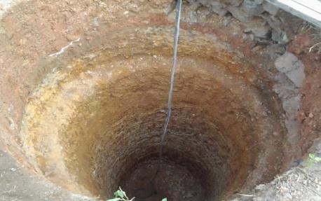
Timor-Leste Journal of Engineering and Science
 Vol.2, Issue.1, pp.1-10, 2021
 Available online at: http://tljes.org/index.php/tljes/data

at the time of Friday prayer, which is as many as 1,360 distribution. Rainfall frequency from the calculation of the
congregations. statistical parameters above, then the estimate is included in
 the Log-normal distribution. Then the rainfall frequency is
 taken as listed in Table 3.
 Table 3. The rainfall frequency distribution using the Log-
 Normal method
 Return Period Log-normal distribution
 T (year) (mm)
 2 103.08
 5 132.39
 10 150.94

 The infiltration well built-in 2014. In the year 2020, the
 rainfall frequency analysis was a redesign. It is conducted to
 find out whether we need the dimensions of the new
 infiltration well or not. The rainfall frequency redesign used
 data from 1993 to 2020 (BMKG, 2012). Mean value as 109.9
 mm and standard deviation as 35.91 mm. It is suitable for the
 Gumbel method distribution after being tested with the chi-
 squared test and the Smirnov-Kolmogorov test.
 Figure 2. The roof plan for Al-Baythar Mosque The conclusion from the analysis of the frequency of
 rainfall data used is the Gumbel distribution. Rainfall
 The method used in this academic community service is
 frequency from the calculation of the statistical parameters
to evaluation to the design of infiltration well system
 above, then the calculation is included in the Gumbel
construction from a pilot infiltration well building on public
 distribution. Then the rainfall frequency is taken as listed in
facilities.
 Table 7.
4. Result
 Table 7. The Rainfall Frequency Distribution Using the
4.1. The Rainfall Frequency
 Gumbel Method
 Infiltration wells with relatively short concentration times Return Period Gumbel Distribution
needed the largest (maximum) rainfall data. Rainfall data is
 T (year) (mm)
sourced from the Banjarbaru Meteorology, Climatology and
Geophysics Agency (BMKG) for 20 years, 1993-2012 2 104.45
(BMKG, 2012). Calculation of Statistical Parameters 5 141.30
Calculation of 5 statistical parameters includes the 10 165.70
calculation of the mean, standard deviation, coefficient of
variation, coefficient of skewness, and coefficient of 4.2. Rainfall Intensity Design
kurtosis. Mean value as 107.7 mm, standard deviation as
34.19 mm, coefficient of variation as 0.32, skewness The intensity of the rainfall frequency is used as the input
coefficient as 0.91, and coefficient of kurtosis as 3.03. discharges at the infiltration well, using hourly rainfall data.
 The chi-squared test was carried out for the four rainfall Assuming that the rainfall is uniformly distributed within a
analysis methods, so the ones that are below the limit value certain duration, the intensity of the rainfall frequency is
are the Log-normal Method and the Gumbel Method. The determined as the intensity of the rainfall with a return period
results of the chi-squared test can be concluded that the of 5 years and the duration of rainfall for 1 hour, then the
acceptable distribution is the Log-Normal distribution with a amount of the intensity of the rainfall frequency is:
Chi² value of 2.5 and Gumbel with a Chi² value of 3.0 smaller 2
than the 5% Chi² table of 5.991. The Smirnov-Kolmogorov 24 24 3
suitability test was carried out for the four rainfall analysis = ∗( )
 24
methods. None of them was an approach to the limit value. where:
Dmax ranged from 0.854 – 1.185 higher than the 5% Do T = tc
Table of 0.36. The conclusion from the analysis of the 0,77
 tc = 0.0195 [ ]
frequency of rainfall data used is the Log-Normal √

 5
Timor-Leste Journal of Engineering and Science
Vol.2, Issue.1, pp.1-10, 2021
Available online at: http://tljes.org/index.php/tljes/data
tc = 2.1208 slow. Calculation of Infiltration Wells with H = 5 m and
So: =1.4 m.
2
132.39 24 3 K = 4.585 x 10⁻⁵ cm/s = 1.651 x 10⁻³ m/hour
= ∗( ) T = 1 hour
24 2.1208
= 27.8 mm/hour I = 27.8 mm/hour
A = 649m2 = 0.000649 km2
Q = 0.278 * C * I* A
4.3. Design Discharge
= 0.278 * 0.95 * 27.8 * 0.000649
If the value of C is taken as 0.95, then the design = 0.00477 m3/s
discharge is obtained as a function of the roof area, namely: = 17.157 m3/hour
QRH = 0.278 x C x I x A (km2) R = 0.7 m
QRH = 0.278 x 0.95 x 27.8 x A (km2) Geometry factor:
QRH= 7.07*A (m3/s) = 2
Furthermore, the QRH value for each roof area on the mosque = 2 ∗ 0,7
building can be seen in Table 4. = 4.4m
So it can be substituted into the formula:
Table 4. Roof Area for Each Building and Design −
= {1 − ( )}
Discharge Value 2
Roof area (A) design discharge (QRH)
km² m³/s m³/jam Table 6. Depth (H) and Number of Wells
0.000649 0.004998 17.99448
Ablution
K Roof (m) Σ Wells
(m)
4.4. Ablution wastewater discharge
6.00 x 10⁻⁵ 12 3 5
Ablution waste water discharge can be calculated by
QRW = 0.004* x max.congregants/4800 1.651 x 10⁻³ 12 3 5
QRW = 8.33333 x 10⁻⁷ x max.congregants (m3/s)
Furthermore, the QRW value for each roof area on the The total depth of infiltration wells required for Al
mosque building in 2014 can be seen in Table 5. Baythar Mosque is 12 m for water from the roof and 3 meters
for ablution wastewater. The infiltration well depth (H) is 3
Table 5. The Use of Ablution Water in Each Time m. For implementation, one well was built for wastewater
used for ablution.
Discharge per Congregation (m³) 0.004 The loss of water into the soil in the infiltration wells are
Congregation Fajr 15 calculated as water seeping through all parts, both the bottom
and the channel cliffs on the original soil or with a porous
Dzuhur 70
coating, with the following data:
Asr 30
Hw =5m
Maghrib 25
Wb = 1.4 m
Isha 20 Ws = 1.4 m
Friday 1,360 =1
K = 4.58497 x 10⁻⁵cm/s = 4.58497 x 10⁻⁷ m/s
Duration (s) 4,800 ∑wells = 5
Discharge (m³/s) 0.001133 So,
4 √ ( + )
=
Permeability coefficient is held out by laboratory tests 2
+ 2√ ( + 2
and direct measurements in the field. Testing by the constant { + √( ) + 1}
head method in the laboratory resulted in the permeability 2√ ( + ) 2√ ( + )
coefficient (K) of 4,585 x 10-5 cm/s for the Al-Baythar q = 3.908 x 10⁻⁵m3/s/m
Mosque. Direct measurement of the infiltration rate with a
Double Ring Infiltrometer from the field obtained results of Design of Infiltration Wells and Examples of Its
1,667 x 10-6 m/s. The research location is silty soil, fine- Application in Al. Baythar Mosque in the year 2014 as part
grained with small permeability, so the infiltrated rate is of academic community service of Faculty of Engineering,
Universitas Lambung Mangkurat. This community service
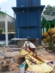
6Timor-Leste Journal of Engineering and Science Vol.2, Issue.1, pp.1-10, 2021 Available online at: http://tljes.org/index.php/tljes/data had an evaluation in 2020 as a form of wastewater ablution km2 from the infiltration well have been additional depth. conservation to surrounding wells. The infiltration wells are proven to be effective in increasing the water level in pump wells as substantiation of the applicability of wastewater conservation in urban public 5. Discussion facilities. 5.1. Rainfall Intensity The rainfall intensity used in this research took place in 5.4. Water Conservation Banjarbaru Station, from years 1993 to the year 2012, as the Water conservation refers to protection, development and rainfall design for infiltration well. Rainfall intensity to the efficient management of water resources for beneficial year 2020 for rainfall redesign. Based on rainfall frequency purposes. There are many examples of water conservation. redesign in 2020, the distribution used is Gumbel methods The infiltration wells are one of the most widely used as distribution. The rainfall pattern after 25 years has no water conservation methods in Indonesia. Infiltration wells significant difference. The difference in the value of the are usually built on soils with shallow groundwater levels, rainfall pattern only took no more than 10% from the design for example, in the study area where the groundwater level in 2014. It means that the design of the infiltration well in is around 5 meters. The infiltration well design is lower than 2014 is still reasonable for further use. It did not have to be 5 meters, with the walls that are left without a waterproof redesign or rebuilt the infiltration well in the Al Baythar layer so that all water that enters the well can be absorbed to mosque in this case. Based on rainfall frequency analysis in the ground and increase the groundwater level. In this case, this rainfall station in the Banjarbaru city has a rainfall data the infiltration wells not only have to function as a reduction that has been well recorded since 1993 to support hydrology of flood but also has a function as an infiltration area that is analysis. able to maintain the groundwater level around the infiltration 5.2. Wastewater Ablution Discharge Design well. Water conservation in this study includes wastewater In 2020, the total of wastewater ablution still used the conservation, such as from wastewater ablution. Water data from 2014, as 0.001133 m³/s, with duration 4800 s. It conservation with infiltration well, where wastewater caused of in 2020 there still be a pandemic that people did ablution is put into the ground, is effective for maintaining not allow to go to the mosque frequently due to activity groundwater level in the research field, and it can maintain restrictions on all public facilities in Indonesia. The activity the quantity of pump well water. The infiltration well built- in the Al Baythar Mosque will be restricted too, so there is in Al Baythar mosque is an example of water conservation not much wastewater from ablution activities. There is no in public facilities in the Banjarbaru city. It can be built in need for a new wastewater ablution infiltration well building. other public facilities around Banjarbaru for water In an academic community in the year 2020, we only need to conservation and to prevent flood disasters. observe the infiltration well building in the year 2014 and to monitoring the pump well around the infiltration well after 6. Conclusion and Future Research five years. The infiltration well can be one solution for 6.1. Conclusion wastewater management in public facilities in an urban area like in the Banjarbaru city. In many studies, wastewater management and water conservation are two separate activities, but not in this case. 5.3. Infiltration Well Design and Monitoring In this research, wastewater ablution management can be implemented as water conservation practice with the Infiltration well in Al Baythar as a pilot project of the infiltration well design. The conclusion of the construction academic community service to apply their knowledge in of infiltration well in 2014 and monitoring in 2020 in Al society. The infiltration wells construction is one solution for Baythar mosque after five years divided as 3 point as 1. handling wastewater ablution in public facilities, especially Infiltration well is effective for wastewater from wastewater the mosques that are widely spread in Banjarbaru city as an ablution in public facilities in the urban areas, 2. Based on alternative to wastewater conservation in Banjarbaru City groundwater monitoring, the results show that the with sufficient groundwater levels. wastewater ablution stored in the infiltration wells can The infiltration well monitoring implemented in the year increase the quantity of pump well water in the area with a 2020. The method used to monitor the effectiveness of the fairly short observation time. The infiltration well in Al infiltration well in Al Baythar Mosque is by observing the Baythar can be used to maintain the water level in the pump water level in the pump wells around the infiltration well as well around the infiltration well, and 3. The infiltration well evidence of water conservation with the construction of not only effective as a prevention method for flood disaster, infiltration wells. As far as five years, the pump well in the but also as wastewater conservation method in public location near the infiltration well never deepened. At the facilities in an urban area like Banjarbaru city. same time, almost all the wells as far as radius more than 1 7
Timor-Leste Journal of Engineering and Science
 Vol.2, Issue.1, pp.1-10, 2021
 Available online at: http://tljes.org/index.php/tljes/data

6.2. Future Research
 This research had a small scope of the area caused is only
based on academic community service in public facilities in
Lambung Mangkurat University, which must be observed
continuously. As the first academic community service
based on research in the water resources civil engineering
field, this service has quite a good impact and can continue
to be developed by other academic staff. The implementation
of infiltration well can be applied in other public facilities
with different cases, such as in-office areas, tourist areas, or
other public facilities in urban areas.

 8
Timor-Leste Journal of Engineering and Science
 Vol.2, Issue.1, pp.1-10, 2021
 Available online at: http://tljes.org/index.php/tljes/data

 Figure 2. Site project of infiltration well

 Figure 3. Infiltration well detail

 9
Timor-Leste Journal of Engineering and Science
 Vol.2, Issue.1, pp.1-10, 2021
 Available online at: http://tljes.org/index.php/tljes/data

Acknowledgments Bandung, Indonesia.

 The research was completed with collaboration between Mardiah, A. M. et al. (2018) “Study on the Effectiveness of
the academic community service and the Hydraulic Infiltration Wells to Reduce Excess Surface Run off in ITB,”
Laboratory, Engineering Faculty of ULM in the year 2020, MATEC Web of Conferences, 147, pp. 1–5. doi: 10.1051
with the title, are "A study of the evaluation performance of /matecconf/201814703008.
infiltration well in Al Baythar Mosque in Banjarbaru City.
And the second, I would like to express my deepest Peraturan Daerah No 5 (2000) Peraturan Daerah KOta Banjarbaru
appreciation to Prof. Dr. Ir. Sunjoto, DIP., HE., DEA (In No 05 Tahun 2000. Available at: https://repository.up.ac.za
memory of the deceased) for his knowledge of this research. /bitstream/handle/2263/64096/LaPlacaHow2018.pdf?sequence=1

References: Prayitno, G. et al. (2021) “Planning and Assistance the Making of
 Infiltration Institusi Pendidikan Islam berupa Pondok Pesantren
Bahunta, L. and Waspodo, R. S. B. (2019) “Rancangan Sumur berperan penting,” 4(1), pp. 212–220.
Resapan Air Hujan sebagai Upaya Pengurangan Limpasan di
Kampung Babakan, Cibinong, Kabupaten Bogor (The Design of PU (2006) “Perencanaan Sistem Drainase Jalan,” p. 99.
Infiltration Wells to Reduce Runoff in Babakan Village, Cibinong,
Bogor Regency),” Jurnal Teknik Sipil dan Lingkungan, 04(01), pp. RPIJM (2015) RPIJM Kota Banjarbaru 2016-2021.
37–48.
 Sunjoto, S. (2016a) Groundwater Engineering. Department of Civil
Bambang Triadmodjo (2008) Hidrologi Terapan. Yogyakarta, and Environmental Engineering UGM.
Indonesia: Beta Offset.
 Sunjoto, S. (2016b) Teknik Drainase PRO-AIR dan Konservasi
Bappeda (2016) Rencana Aksi Kota Hijau (RAKH) Kota Berkelanjutan.
Banjarbaru Tahun 2016.
 Sunjoto Sunjoto. (1994) “Infiltration well and urban drainage
BMKG (2012) Data Hujan Online. Jakarta. Available at: concept,” Future groundwater resources at risk, (222), pp. 527–
http://dataonline.bmkg.go.id (Accessed: January 30, 2016). 532.

Chow, V. Te, Maidment, D. R. and Mays, L. W. (1988) Applied Suratkon, A., Chan, C. M. and Tuan Ab Rahman, T. S. (2014)
Hydrology, McGraw-Hill Book Company. McGraw-Hill Book “SmartWUDHU’: Recycling ablution water for sustainable living
Company. doi: 10.1061/(ASCE)1090-025X(1999)3:3(132). in Malaysia,” Journal of Sustainable Development, 7(6), pp. 150–
 157. doi: 10.5539/jsd.v7n6p150.
Fachrurazie, C., Firman Arifin, Y. and Sri Susanti, D. (2002)
“Analisa Drainase Sumur Resapan Pada Kampus UNLAM Suripin (2004) Sistem Drainase Perkotaan yang berkelanjutan.
Banjarbaru,” Info-Teknik, 3(1), pp. 24–34. Yogyakarta, Indonesia: Andi Offset.

Hirijanto, Mundra, I. W. and Wedyantadji, B. (2021) “Infiltration Tamelan, P. G. and Kapa, M. M. J. (2020) “Rainwater harvest using
Wells Alternatives to Reduce Water Puddle in Lowokwaru District well infiltration technology in the dry land rural areas with semi arid
, Malang City,” 2(1), pp. 1–8. climate,” 6587(December), pp. 6577–6587.

IKA, S. (2007) Pedoman Umum Pembangunan Sumur Resapan UU RI No. 26 (2007) Undang-undang No 26 Tahun 2007 tentang
dalam Rangka Antisipasi Kekeringan tahun. Jakarta, Indonesia. Penataan Ruang.

Isramaulana, A. (2016) “Rencana Anggaran Biaya Untuk Sumur Wesli et al. (2013) “the Effect of Land Use and Community
Resapan Masjid Besar Kota Banjarbaru,” Info Teknik, 15(2). Participation on Flood Control At North Aceh District,” Indonesian
Available at: https:// ppjp. ulm.ac. id/journal/ index.php/ infoteknik/ Journal of Geography, 45(2), pp. 171–186. doi: 10.22146/ijg.4874.
article/view/ 226.

Kimpraswil (2000) Petunjuk Teknis. Tata-Cara-Perencanaan-
Sumur-Resapan-Air-Hujan-untuk-Lahan-Pekarangan.pdf.

 10
You can also read