A Traveler's Guide to Craco and Basilicata
←
→
Page content transcription
If your browser does not render page correctly, please read the page content below
A Traveler’s Guide to Craco
      and Basilicata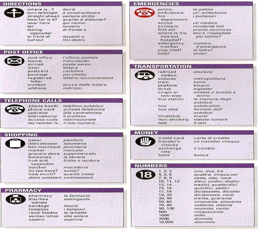
The Craco Society

Dear Traveler,

This guide is designed to assist you in getting the most out of your visit to Craco
and Basilicata. The material includes a brief history of the town and region with
suggestions about many of the sites we feel are worth visiting during your stay.

You will also find a detailed map of Craco Vecchio, published in 1939, which
contains street names and property numbers. Through additional research, the
Society has been able to correlate these property (map) numbers with the past
street addresses. With the ability to now accurately locate these former
domiciles, anyone who knows where an ancestor was born or lived can now find
this location on the map, and perhaps, explore it in person.

We have also included a section containing a map of the new town (Craco
Peschiera), along with a list of surnames in the new town. In addition, there is a
very small phrase guide to help you communicate in Italian and a guide to
speaking Cracotan which contains words and phrases you may have heard as a
child growing up with Cracotan parents.

We hope this booklet serves in some small way to enrich the experience of a
journey back to our roots and allows you to have both a memorable and
enjoyable stay in Craco.
Contents

Welcome! – “Benvenuti!” ........................................................................................................2
A Brief History of Basilicata ..................................................................................................... 4
Observations about the Region ................................................................................................ 6
History of Craco .......................................................................................................................8
Craco Population (Census inhabitants) ..................................................................................... 11
Churches of Craco ..................................................................................................................... 12
Craco Today .............................................................................................................................. 15
Craco Peschiera ......................................................................................................................... 16
Craco Peschiera – Surnames ..................................................................................................... 17
Italian Phrase Guide .................................................................................................................. 18
Staying in Basilicata................................................................................................................... 20
Suggested Day Trip Excursions ................................................................................................. 21
Map of Craco Vecchio – 1939 ................................................................................................... 32
Craco Vecchio: Street Names and Civic Numbers .................................................................... 33
Parlë Crac’tan? Guide to Speaking Cracotan ........................................................................... 46
About The Craco Society ........................................................................................................... 63
Welcome! – “Benvenuti!”

Craco has always been an amazing place but now it seems to be finding a revitalized interest.
Perhaps it is the thousand year history that gives the town an appeal far beyond any
accomplishment or contribution it ever made to history. Or it may the haunting beauty and
mystery of the abandoned town that draws attention to the casual observer. But for us it is
more – it is our home. For no matter how many generations we are removed from the town it
is still in our blood.
Many people who seek their history are perplexed with the challenge of finding where they
came from. Yet Craco, for some reason, left an imprint on her children who passed it along to
their descendants. We know of over 1,500 sons and daughters of the town who left during the
bleak times of the late 1800’s to find opportunity. In their new lands they maintained contact
and provided support for their old village. But as they assimilated into new cultures they
preserved Craco for the future by making sure their children and grandchildren knew about
their heritage.
So as we prepare to make this journey back into our past we hope the enclosed material will
contribute to making your experience memorable. It is our sincere hope that you will be
overflowing with lifelong memories of Craco when you return. Please follow the advice of our
ancestors as you travel so you can savor and enjoy the trip and our companionship during the
upcoming week; “Ci va chianë, va sanë e va lundanë” - he who travels slowly goes safely and
goes far.

A presto!

                                              2
3
A Brief History of Basilicata

The very ancient land known as Basilicata was already inhabited in the prehistoric age. The
settlements of Venosa and the Bradano Valley date from the Palaeolithic period while the
organized agricultural villages around Matera and Melfi sprang up during the Neolithic period.
From that time until the Bronze Age the region became an important centre of communication
between the Ionian and Tyrrhenian populations, giving rise to important settlements. The
inland regions began to be populated during the Iron Age. It was during this phase that many
Indo-Europeans arrived in Lucania, among whom the Liky from the Illyrian coast. In the 8th
century B.C. Greek colonists landed on the Lucanian shores of the Ionian Sea.

This historic event gave birth to the flowering civilization that will be remembered in history as
the Magna Grecia. Metaponto, Siris, and Heraclea were the most important settlements.
Between the 6th century and the 5th century B.C., Osco-Sabellic tribes came down from the
Irpinia, while the Lucanians settled the more inland regions. Later, in the 5th and 4th centuries
B.C., the Lucanians attacked the Greek colonies along the Ionian coast in their quest for new
land to cultivate. Meanwhile, between the 4th century and 3rd century B.C., the Romans
pushed their way into Lucania as they continued their expansion. At first the Lucanians were
allied with the Romans against the Samnites. Later, not wanting to yield to Roman domination,
they allied themselves with the Samnites and the Greek colony in Taranto to combat the
Romans.

Meanwhile, in 291 B.C., Venusia (today Venosa) becomes the first Roman colony in Lucanian
territory. The Romans fought against Pyrrhus who was rushing to the aid of the Greek colonies,
and lost a battle that took place between the areas of Metaponto and Heraclea (today
Policoro), which became famous for the heavy losses incurred on both sides. In the northeast,
Roman domination increased: the town of Grumentum (today Grumento) was founded and the
road that connects Grumentum to Venusia was constructed (Via Herculia). In 280 B.C. the era
known as Magna Graecia ended. In the 2nd century B.C. Lucania was under Roman domination.
The proud and warlike Lucanians rebelled against Rome when they decided to impose landed
estates, but were defeated. From 27 B.C. to 14 B.C., under the Augustan Empire, Lucania was
divided into two parts and unified with Apulia, the Regio II, and with Brutium, the Regio III.

At the end of the 3rd century Dioclesian reunited the area, unifying it with Brutium. With the
decline of the Western Roman Empire the region sunk into deep isolation, which destroyed the
already impoverished economy. By the Middle Ages, between the 6th century and the 9th
century, the Lombards annexed Lucania (with the exception of the Byzantine possessions in the
region of Matera) to the Duchy of Benevento. The Byzantines, gathered in Lucania in their
effort to escape religious persecution in the Orient, give life to the phenomenon of the
Rupestrian (rock) Churches. They proliferate in the area around Matera. Meanwhile, the
Saracen invasions forced the Lucanians to retreat to the surrounding mountains and hills.
Between the 8th century and the 9th century, Matera was annexed to the Duchy of Benevento,
while the rest of the region passed to Byzantine domination.

                                                4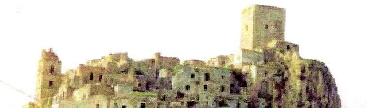
In the 11th century and 12th century the Normans conquered Lucania, making it the centre of
Italian political life. In 1059, Melfi is the capital of the Norman realm. When Norman
domination ended, the Swabians and Angevins competed for control of Lucania and southern
Italy. Frederick II of Swabia was born in 1231, in Melfi. He enacted the Constitutiones Utriusque
Regni Sicilae (the Constitutions of the Two Sicilies). At the end of the 13th century the Angevins
took control the Realm of Naples and the Two Sicilies. Feudalism began in this period, with
many Lucanian lordships springing up but they were opposed by the Aragonese. The Barons,
faithful to the Angevins, tried to overthrow the Aragonese Reign and the 'Congiura dei baroni'
(baron conspiracy) was planned in the Miglionican Castle in 1441.

Between the 13th century and the 16th century Bourbon power consolidated. Certain Albanian
communities arrived in Basilicata, settling along the slopes of Vulture and the Pollino Massif. In
1663, Matera was the capital of the Lucanian Province of the Kingdom of Naples. This period
witnessed the beginning of bloody rebellions by peasants against the barons who exploited the
land, forcing the population into famine. In 1707, the Austro-Sabaudian army occupied Lucania,
and after the Treaties of Utrecht and Rastadt it passed into the hands of Charles VI of Austria.
The Bourbons returned to power with the Peace Treaty of Aquisgrana. In 1799 a peasant
rebellion was repressed with mass executions. Then power passed briefly to the French, who
after a short time were forced to return it again to the Bourbons. A part of the Lucanian
bourgeoisie however continued to adhere to the 'Moti carbonari' (Carbonari uprisings).
Between 1861 and 1868 the entire region was affected by the phenomenon of Brigantaggio
(banditry), rebellions against power generated by the extreme isolation of the population and
which found an ideal habitat in the thick woods of Mount Vulture.

At the beginning of the 20th century, in 1902, the first meeting of Socialists occured in Potenza.
Poverty had reached unacceptable levels and the phenomenon of emigration began, reaching
its high point in 1913. In 1943, Matera was the first southern Italian province to rebel against
Nazi-Fascist occupation. When World War II ended, it became necessary to tackle the problem
of the 'Sassi of Matera' (ancient rock dwellings) which, because of overpopulation, had become
a health risk. In 1952, a state law decreed the evacuation of the Sassi district. During the same
period 'Riforma Fondiaria' (land reform) began and transformed the face of the region.

Unfortunately, the emigration damages to the communities of Basilicata from prior years left
the area demographically impoverished. The 1980 earthquake in Irpinia created serious
problems in the entire northern region and in the capital Potenza. The University of Basilicata
was established in Potenza in 1984, and a few years later opened a campus in Matera. In 1986,
the Italian government enacted a law to finance the restoration of the Sassi of Matera, which is
still being carried out. At the beginning of 1994, UNESCO declared the Sassi of Matera a
“heritage of humanity to be handed down to future generations” and included it among the
territories under its protection. Following that FIAT established an enormous factory in the
industrial zone of S. Nicola of Melfi and in the same year the National Park of Pollino was
established. 1

1
    APT Basilicata website: http://www.aptbasilicata.it/History.52+M52087573ab0.0.html

                                                        5
Observations about the Region
Southern Italy, known as “Mezzogiorno” (land of the midday sun) by Italians, is an area marked
by lonely villages and empty untrammelead landscapes. Clichéd images in rural areas still
prevail with shepherds driving herds of sheep across stony hills, black-clad peasant women,
washing hung across streets, and classic passions of food, family, love, and religion. Poverty,
crime and other social ills are amplified here along with Old World ideals of honor and
hospitality. 2 These images and ideals were strong influences on the inhabitants who pass them
along to their families.
Geography molded the character of the region by placing it far from markets and unable to
support industrialization or large scale agriculture. Climatically, during the summer months it
bakes under an almost African sun impeding agricultural development and in areas away from
the coast the winter is bitter and cold. 3 The poor soils are unsupportive of agricultural
development and the mountains are devoid of raw materials.
Historically, the region was endlessly conquered by Phoenicians, Carthaginians, Greeks,
Romans, Arabs, Normans, Swabians 4, Angevins 5, and Bourbons. 6 For centuries it remained in a
feudal system and finally in the hands of Spanish rule, stagnation developed that continues to
this day. 7 This system of land ownership known as “latifondi” where large estates employed
landless laborers was exacerbated in the 1860’s by confiscation of church lands during Italian
unification. 8 During the next 20 years conditions for peasants declined further as more land
went to private owners who deforested it increasing the spread of malaria and landslides. In
the 1880’s Europe suffered an agrarian crisis which brought ruin to many of the Southern Italian
landowners and also diminished the economic situation of the peasants. In the 1880’s fewer
than half the children lived past the age of 15! 9
Small and mostly mountainous, the region is situated at the “instep of the boot” in Southern
Italy. It has large tracts of barren and eroded wasteland resulting from systematic
deforestations over the centuries. The enormous emigration of the past left it under
populated. The economy is mostly based on subsistence agriculture, with the eastern and
central areas are almost desert-like. Industrial development is low, but there are some
2
Insight Guide: Southern Italy, Langenscheidt Publishers Inc., Maspeth, NY, 2001
3
Italy, Fodor’s 2001.
4
Swabians were a Germanic group from the Danubina Plain of the Hungary-Romania area.
5
Angevins were the Anglo-French dynasty of the first millennium. King Richard the Lionhearted was one of the
more famous rulers of this family.
6
The Bourbons were the ruling house of French from the 1600’s to the French Revolution.
7
Passage to Liberty: The Story of Italian Immigration and the Rebirth of America, Ciongoli, A. Kenneth and Parini,
Jay, 2002.
8
Between Salt Water and Holy Water: A history of Southern Italy, Astarita, Tommaso, W.W. Norton & Company,
New York, London, 2005, page 288.
9
Between Salt Water and Holy Water: A history of Southern Italy, Astarita, Tommaso, W.W. Norton & Company,
New York, London, 2005, page 289.
6flourishing crafts sectors, such as ceramics, woodwork, and textiles. Tourism is mostly along the
Tyrrhenian coast. 10
Archeological findings show areas around the region’s rivers were inhabited since Paleolithic
times. In the 13th century BC the Lyki, probably the origin of the name Lucani, which is another
name for the people of the area, came from the Danube area of northern Europe settling the
region. In the following century they were enriched culturally by the Greeks who colonized the
area. The Lucani established a strong military state and fought against the other inhabitants of
Apulia for centuries. After being allied to the Romans, they sided with Hannibal in the Punic
Wars. Under the Roman Empire the region was called Bruttium. In the Napoleanic era it was
under the control of Naples which was allied with the French. After 1815 it was part of the
Kingdom of Two Sicilies which was under Bourbon control. Then between 1932 and 1945 was
renamed Lucania and finally became "Basilicata" under the Republic. 11
Today Basilicata is divided into two Provinces, Matera and Potenza. Potenza serves as the
administrative center for the region and is the major city associated with it. However, the
Italian province of Matera has in it the “comune” of Craco, the hometown of over 1,500 families
who left there between 1892 and 1922 for opportunities in North America.
Craco Peasant Costume 1795 12
10
Italy, Gillman, Helen, Lonely Planet Publications, Hawthorn, Australia, 3rd Edition, January, 1998.
11
http://www.italyworldclub.com/basilicata/index.html
12
Costume del Paese di Craco prov.MT (anno 1795), Gouache su carta, mm. 308 x 235. Museo degli Argenti e delle
Porcellane presso Palazzo Pitti Firenze (Dir. dott.ssa Marilena Mosco.).
7Craco
Craco c. 2000 Joseph Di Sipio photo
Located about 25 miles inland from the Gulf of Taranto at the instep of the “boot” of Italy the
medieval village of Craco is typical of the hill towns of the region with mildly undulating shapes
and lands surrounding that it sown with wheat. Craco was built on a very steep summit, in
medieval times for defensive reasons, giving it a stark and striking appearance and
distinguishing it from the surrounding lands which are characterized by soft shapes. The center,
built on the highest side of the town, facing a ridge runs steeply to the southwest where newer
buildings exist. The town sits atop a 400 meter high cliff that overlooks the Cavone River
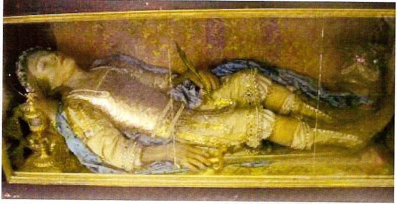
Valley. Throughout the area are many unique vegetation-less mounds formed by intensive
erosion that are called “calanchi.”
Calanchi
8Little is known about ancient Craco but tombs dating to the first century were found in the
Sant’ Angelo area and it is assumed that an indigenous settlement was established by then.
Around 540AD the area was called “Montedoro” and inhabited by Greek monks who moved
inland from the coastal town of Metaponto. The town’s name can be dated to 1060 when the
land was the possession of Archbishop Arnaldo, Bishop of Tricarico, who called the area
“GRACHIUM” which means from the little plowed field. 13 This long association of the Church
with the town has had a great influence on the inhabitants.
From 1154-1168 the control of the village passed to Eberto who established the first feudal
control over the town. After that in 1179 Roberto di Pietrapertos became the landlord of
Craco. In 1276 a university was established in town. During this period in the 13th Century the
landmark castle was built under the direction of Attendolo Sforza. 14 In 1293 under Federico II
the Castle Tower became a prison. By the Fifteenth Century four large palazzi had developed in
the town:
• Palazzo Maronna near the Tower
• Palazzo Grossi near the church of San Nicola Vescovo
• Palazzo Carbone on the Rigirone’s property
• Palazzo Simonetti
Credit Pierfrancesco Rescio, Storia E Architettura Di Craco:
13
CRACO La Sua Storia, Amministrazione Communale, Craco, MT, no date.
14
Il Paesaggio di Craco.
9The population of the town went from 450 (1277), to 655 (1477), and 1,718 (1532) until
reaching 2,590 in 1561; and averaged 1,500 in succeeding centuries. During 1656 a plague
struck with hundreds dieing and reducing the number of families in the town.
By 1799 there was enough impetus to change the feudal system and Innocenzo De Cesare who
had been a student in Naples returned and promoted an independent Municipality. This led to
the town coming under the control of the Italian King but was followed by a period of French
occupation. By 1815 the town was large enough to divide it into two districts:
• Torrevecchia – the highest area adjacent to the castle and tower
• Quartiere della Chiesa Madre – the area adjacent to San Nicola’s Church.
With the unification of Italy there was a growth of “brigands” in the area who plagued the town
until mid-1860. With the end of the civil strife the greatest difficulty the town would face were
from environmental and geological factors.
By the 1880’s conditions in the region deteriorated as a series of events changed the economic
and social conditions. These included almost annual catastrophes that seemed to compound
the distress on the population and can be summarized with the list below:
• 1884-1887 Cholera epidemics take over 55,000 lives in the south
• 1887 Trade relations with France are severed
• 1888 Beginning of trade war with France
• 1888 Legislation recognizes the right to emigrate
• 1890 The plant disease Phylloxera destroys the grapevines in the south
• 1890 Drop in agricultural prices causes a trade war
• 1894 Major land reforms proposed to try to quell Sicilian unrest
• 1894 Large earthquake
• 1898 Bread riots throughout Italy lead to suppression of civil rights
Meanwhile, in the New World, economic conditions had created a huge demand for labor and
offered social structuures that enabled individual accomplishment and rewarded hard work.
This combination of events triggered an exodus.
From 1892 - 1922 over 1,300 Crachesi left to settle in North America because the poor
agricultural conditions created desperate times as the land was not producing enough for the
people. Other important factors were earthquakes, landslides, and war.
10During the mid-Twentieth Century recurring earthquakes began to take a toll on the viability of
the town until between 1959 and 1972 the village was almost totally destroyed by a series of
landslides. The geological threat to the town was known to scientists since 1910. Originally
built “on a hill of Pliocene sands overhanging the clays, with ravines causing progressive
incisions” 15 Craco was doomed. Now, Craco is uninhabited. Starting in 1963, the 1,800
inhabitants were gradually transferred to a valley in a locality called Craco Peschiera. That
population is now below 800 inhabitants.
Craco Population (Census inhabitants) 16
15
http://www.hsh.it/cracoricerche/pages/cennistorici/_tourist_info.htm
16
http://it.wikipedia.org/wiki/Craco
11Churches of Craco
Churches are central to the town’s history with its founding stemming from monks.
Noteworthy buildings include the church of the Observant Friars Minor dedicated to St. Peter,
which dates back to 17th century and has now been partially restored and used as a Conference
and Tourist Information Center. This complex has several components with the oldest structure
being the church (c. 1620) and the convent (1630-1631). 17
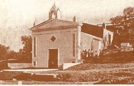
The major church in the old town was San Nicola Vescovo (St. Nicholas Bishop) and was also
known as “La Chiesa Madre” or Mother Church because of the role it played in the town. Its
arched dome stands above the skyline just below the Tower and was the largest church in the
village.
S. Nicola Vescovo in Craco Vecchio
With the collapse of the old town the statuary and interior fixtures were moved to a new
church building which is now in the center of the new town, Craco Peschiera. Although modern
in appearance on the outside the old statues inside from the original church provide a
transition to visitors that give them the atmosphere of old Craco.
S. Nicola Vescovo in Craco Perchiera
17
Storia e Architettura de Craco, Resco, Pierfrancesco, Basilicata Reginal News, 1998.
12Also located in the heart of the old town were two small chapels that were dedicated to saints
and used primarily on the feast days of their namesakes. The Cappella di Santa Barbara was
located in the Terravecchia area while the Cappella di San Rocco was at the Palazzo Maronna.
Several families also maintained private chapels or alters in their homes to venerate patron
saints.
The church of the Madonna della Stella, a small chapel built on the
hillside is part of an active association paying homage to the Virgin
Mary. The site of the chapel is the location where the statue of the
Virgin and Child was miraculously discovered in a body of water by a
shepherd. The statue of the Virgin is still housed there although the
original infant was stolen and replaced.
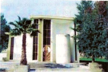
There is also a small new church in Sant’Angelo, the only remaining section of the hilltop that is
still inhabited, which houses the religious relic of the mummified body of San Vincenzo the
martyred patron saint of the town. It is actively attended to with fresh flowers brought into the
church daily. San Vincenzo was a soldier in the Legion of Tebea, in service to the army of
General Massimiliano in 286CE who was martyred because he refused to renounce Christianity
and worship the Emperor Marco Aurelio. A relic was brought to the town in 1769 and his body
arrived in 1792 and was housed in the Monestary. It was moved to the new little church after
the old town collapsed and the Monestary was damaged. A story is told of another town,
Pisticci claiming the relic should be in their town and a group from there tried to take the relic.
It became too heavy for them to carry very far and was abandoned on the road where the
people of Craco found it and returned it to the town.
Relic of San Vincenzo
13This strong religious connection in the town generates many regularly scheduled festivals:
• Madonna della Stella Festival – first Sunday of May in Craco Vecchio
• San Nicola Festival – second Sunday in August
• Madonna della Stella Festival – second Sunday of August in Craco Peschiera
• Madonna di Monserrato Festival – third Sunday of September
• San Vincenzo Fair – fourth Saturday of October in Craco Vecchio
• San Vincenzo Martire – fourth Sunday of October
The agricultural traditions of the town also continue with a local market held in Craco Peschiera
each month.
COAT OF ARMS OF CRACO
An arm with three grain ears in hand
14Craco Today
Today, the old village majestically rises with its Norman Tower, visible in the surrounding valleys
retaining a special charm that attracts tourists as well as old inhabitants. Although abandoned,
its ancient construction makes it look like a city of 2000 years ago and has served as the set for
several movies that are trying to portray a very old village. These include:
• “La Lupa” (1953)
• “Cristo si e fermato a Eboli” (Christ Stopped at Eboli) 1977
• “King David” (1985)
• “Saving Grace” (1986)
• “il sole anche di notte” (Night Sun) 1990
• “The Passion of the Christ” (2004)
• “The Nativity Story” (2006)
It also served as a vignette in a television documentary called “The Colors of Italy” illustrating
how modern perspectives of the town find it a charming backdrop to reflect ancient times.
In 2010 Craco was named to the World Monuments Fund Watch List.
15Craco Peschiera
Map of Craco Peschiera
16Craco Peschiera – Surnames
Province of Matera, Region Basilicata, Italy
INFO: -- Population: ca. 850 inhabitants -- Zip/postal code: 75010 -- Phone Area Code: 0835
SURNAMES: [154 different surnames presently recorded in the phone directory]
(the number after each surname refers to the number of families - no number means one family)
ALIANI 2 * ALIANI SCARPETTA * ALIANO * ALO' * ANDRISANI * BAGLIVO VIGNOLA *
BAGNULO TRIANNI * BARBALINARDO 2 * BARBARO 2 * BARTOLOMEO * BITONTO 3 * BLOISI
2 * BOFFILO * BORNEO * CACCIAPAGLIA * CAMMISA * CAMPERLENGO * CANDIA *
CAPOGROSSO MONTEMURRO * CASCINI 3 * CASELLA 2 * CASTO 2 * CAVALERA * CHIRONNA
* CIFUNI * CIPOLLINI 3 * CIPOLLINO * CLEMENTE 2 * COLABELLA * COLABELLA LAVAIA *
COLANGELO 2 * COLLEVECCHIO * COLONNA 3 * COPETA ALIANO 5 * COPETI 3 * COPETI
LISANTI * COVELLA * COVELLA PECORARO * COVELLI COPETI * COVIELLO * CRAPULLI *
D'ADDIEGO * D'AMBROSIO * D'AMELIO * D'ELIA 4 * D'ONOFRIO 5 * D'ONOFRIO L'EPISCOPIA
* DADDIEGO * DAMATO 2 * DE FELICE 2 * DE LIA * DE ROSA * DI DIO * DI SANTO * DI
SANTO COVELLA * DI SANTO 3 * DI STEFANO 3 * DICHIARA * DUCA 2 * FANTASIA *
FERRANTE 2 * FITTIPALDI * FORNABAIO * FORTE * FORTUNA * FUMAROLA * GALLOTTA 2 *
GENTILE * GERMINO * GIAMPIETRO LATEGANA * GIANGRECO * GIULIANI * GRIECO *
GROSSI 4 * GUARIGLIA 2 * IANNUZZIELLO 2 * L'EPISCOPIA * LACICERCHIA 3 * LACOPETA 3
* LAPACCIANA PANARELLA * LAPILLA * LATEGANA * LAURIA ALIANI 5 * LAURIA ALIANI
POIDOMANI * LAVAIA 2 * LAVIERI 6 * LAVIOLA * LISANTI 3 * LO FRANCO 4 * LOFRANCO 3 *
LONGOBUCCO 3 * LOPATRIELLO * LOPORCHIO * LORUBIO 4 * LOSPINOSO 3 * LOSPINOSO
PACIGLIO * MAFFEO 4 * MAGISTRO * MAGNANTE * MANIGLIA * MAROTTA * MARRAUDINO *
MASTRONARDI 2 * MATTOSSOVICH * MERCORELLA * MIGGIANO * MITIDIERI * MODENA 2 *
MONTEMURRO 10 * MORMANDO 5 * NICOLETTI 2 * NUZZO 3 * PALESE * PANARELLA 2 *
PECORARO 2 * PETRACCA 4 * PETRACCA COPETI * PIRRETTI * POIDOMANI 2 * PUCCI *
PUCCIARIELLO * QUARATO * RAGONE 2 * RINALDI 7 * ROMANO * RUBINO * SABATO
BOLLETTIERI 4 * SACCO 2 * SANCHIRICO D'ONOFRIO * SANTANGELO * SANTORO *
SCARCIOLLA * SCARPETTA 2 * SCAZZARIELLO * SECCAFICO 5 * SECCAFICO LOSPINOSO *
SERRA * SILLARI * SPENNATO * SPERA 4 * SPERA RAGONE * STIGLIANI * STIGLIANO *
STIGLIANO PACILIO * STRAMIELLO 2 * TORNAQUINDICI * TRIANNI CIMINNELLI * TRICARICO
* TURCO * TUZIO * VIGNOLA 2 * VINCIGUERRA * VITARELLE * VITELLI 3 *
copyright italyworldclub - all rights reserved
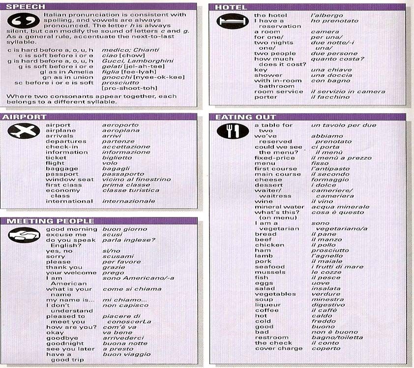
17Italian Phrase Guide
1819
Staying in Basilicata
Traveling to Southern Italy can be intimidating for those not familiar with the Italian language,
as English is not commonly spoken in these regions. Travel options to visit Craco are limited to
renting a car and driving, or taking a train from any major airport to Ferrandina (about 5 hours
from Rome, or 2 ½ hours from Bari) and then securing the services of a taxi for the short trip to
Craco.
Hotel options are also somewhat limited in the area. There are a few “agriturismo” to consider,
but they typically will not be able to help you with travel arrangements or be fluent in English.
Magna Grecia and Club Med have resorts nearby on the Ionian Sea, but they tend to cater to
local residents looking for a seaside holiday.
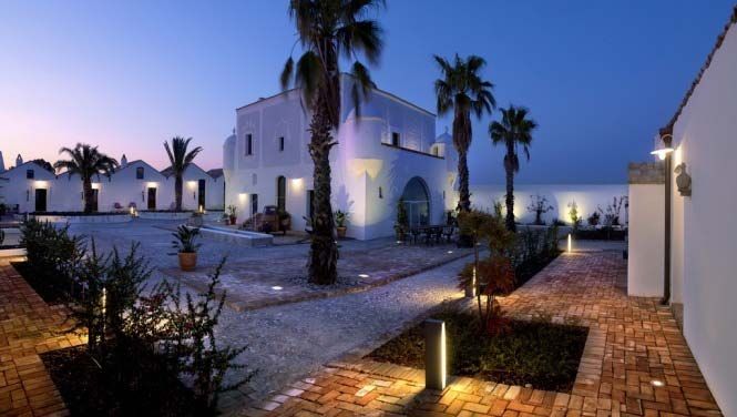
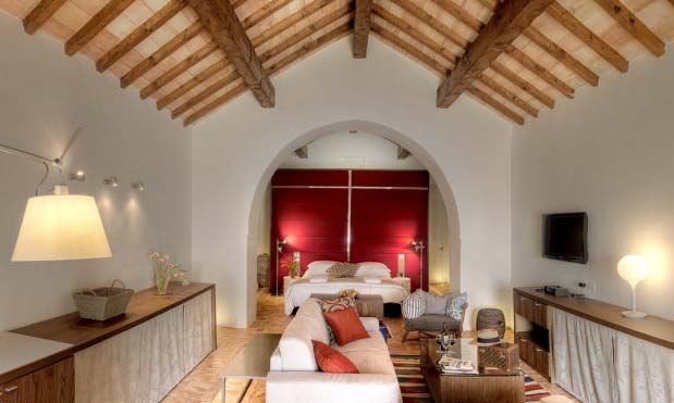
Another option, which we highly recommend, is staying at the Torre Fiore Hotel, located on the
outskirts of Pisticci. The staff speaks English, they offer airport transfers, can arrange local
tours, and provide five star authentic Lucanian dishes.
This luxurious facility was originally built as a military outpost to guard against Turkish
invasions, but now offers 13 private suites along with a wine cellar, a restaurant with valley and
sea views, a pool with a bar and lounge, wireless internet access, formal and informal gardens
and courtyards, complementary shuttle to and from Torre Fiore beach facility, cultural classes
and tours (history, arts, cooking, music) and even an outdoor pizza oven!
For further information about staying at the Torre Fiore Hotel you can reach them via
telephone: 39 0835 580 239, write them at Torre Fiore Hotel, Contrada Terranova, 75015,
Pisticci, Italy, or by contacting Frank Giannone at fgiannone@framgroup.com.
Visit their website at www.www.hoteltorrefiore.com.
20Suggested Day Trip Excursions
3 Cities Tour: Pisticci, Bernalda, and Ferrandina
PISTICCI
In the midst of the Valle del Basento and Cavone is where one will come across Pisticci, spread
over three Calanchive (gully/ravines) hills not many kilometres from the Jonic Coast.
History
Pisticci’s foundation came about at the hands of the Enotri during the Iron Age (IX
century BC) as testified by Necropolises (VII century BC) found on the territory. It was a
centre in contact with the Greek culture of Metaponto, providing enduring and vast
cultural influences.
During the V century BC it excelled in pottery production in Attic style which had its
major exponent in the so called “Pittore di Pisticci” (a Pisticci artisan); probably an artist
who had emigrated from Greece.
During the III century BC, following the defeat of Taranto, Pisticci came under the orbit
of Rome and over the years became an important agricultural centre; mainly for olives.
Its name derives from the Latin, Pesticius that is pasture land. Another etymology
suggests it derives from the Greek pistoikos, signifying “loyal place”, seemingly a
named earned in the field of war against the Romans (III century BC).
During the High Medieval period it was a Byzantine centre which saw the arrival of
Basilian monks escaping from persecution in the East. These monks formed new
communities and also erected monasteries in Pisticci. The district of Terravecchia was
created and then made a fief of the Normans during the XI century.
Under the Swabians, Pisticci was assigned to the Sanseverino family (1212) who were
succeeded by the Spinelli family during 1553. It then passed to the Acquara and
Càrdenas families.
Over the centuries the terrain where the village lay gave way to landslides. The one
during 1688 was terrible and caused partial demolition of the ancient district of
Terravecchia.
A visit to the City
The Mother Church, dedicated to Saints Peter and Paul, is situated in a panoramic
position facing the ruins of the ancient Norman Castle. It houses canvases from the
Neapolitan School and precious wooden altars. Its bell tower dates back to the era of
the previous church (XII century).
21In the City, which is characteristic for its white houses, one will come across the
Sant’Antonio Church which preserves canvases of Domenico Guarino. In the ancient
district of Terravecchia, at 1km from the Village, one can visit the Santa Maria del
Casale Abbey (XI-XII century).
In the San Basilio locality, one can visit the Masseria Berlingieri, derived from the Castle
which was erected during 1050 by Robert Guiscard, then handed over to the Basilian
monks (1133) and later the Benedictines.
Places of interest
The ruins of the Norman Castle; The Mother Church of Saints Peter and Paul (1542);
Sant’Antonio Church or Convent; Madonna of Loreto Church; Franchi Tower; Dirupo
District; Palazzo Giannantonio; Palazzo De Franchi; Palazzo Rogges; Palazzocchio;
Immaculate Conception Church (XVI century); Santa Maria del Casale Abbey (XII
century); Masseria in the San Basilio locality; Excursions to San Teodoro Nuovo (VII
century BC).
Events
Feast of Sant’Antuono on 17th January; Feast of the Assunta on 15th August; Feast of
San Rocco on 16th August; Feast of the Madonna delle Grazie on the 2nd Sunday of
September in Marconia.
BERNALDA
At the very end of the Valle del Basento, in a panoramic position is where Bernalda is
positioned between two rivers, the Bradano and Basento. It is not too far from the Jonic coast
where Metaponto is located.
History
This centre has medieval origins, but the territory where Bernalda was founded hosts
Lucani and Greek settlements. Archaeological finds have identified an ancient centre
not too distant from the modern habitation.
The City’s coat of arms strongly re-establishes ties with rural symbolism depicting an ox
surrounded by ears of wheat.
The centre’s origins date back to around the X or XII century, when it assumed the
name Camarda. It wasn’t until 1470, that it became known by its current name, being a
contracted form of the feudatory Bernardino de Barnaudo, secretary to the Aragonese
King. This feudatory saw the construction of the Castle in the village, which
immediately became his family’s residence.
The fief was then sold to the Navarreta Family in 1609 and remained theirs until the
end of feudal rights sanctioned by law by Giuseppe Bonaparte during 1806.
22After a brief period characterised by the Republican motions and major figures during
the Renaissance period under the Bourbon Reign of the Two Sicilies, Bernalda passed
into the Reign of Italy in 1861.
The 20th century strengthened the City’s economy through tourism, both seaside and
archaeological. Every year, the splendid Jonic beaches and Archaeological Park in
Metapontino attract more and more visitors.
A visit to the City
The nucleus of a visit to Bernalda is Piazza Cavour where one can admire the majestic
Aragonese Castle dating back to the XV century, which is positioned in front of the
Chiesa Madre (Mother Church) dedicated to San Bernardino (XVI century). From here
one can enjoy a beautiful panorama over the Valle del Basento.
The Sant’Antonio Convent, seat of the town hall, and the ancient San Donato Church
(XI-XII century) complete the picture of architectural works in Bernalda.
Tourists also visit Bernalda for its close proximity to the splendid Jonic Coast, where
they can enjoy clean waters and beaches that have been recognised by the Bandiera
Blue over the last few years.
The grandfather of the Italo-American film director Francis Ford Coppola was born in
Bernalda.
Places of interest
The Aragonese Castle (XV century); Chiesa Madre of San Bernardino (XVI century);
Sant’Antonio Convent (XVII century); Chiesa San Donato (XI-XII century).
FERRANDINA
In a territory that is characterised by the presence of numerous olive trees, which produce
excellent Majatica oil, is where one will find Ferrandina, a locality of the Basento Valley.
History
It was founded by Greeks or Trojan refugees around the X century BC, by the name of
Troilia, meaning small Troia. It had an acropolis known as Obelanon by the Romans,
which subsequently became Uggiano.
During the Imperial era, it lost importance because the Romans concentrated more on
the development of the road network leading from Calabria to Puglia.
During the Byzantine era, the first Castle (VI century) was built. In the subsequent
century, under the Longobards (VII century) it became part of the Gastaldo of
23Latiniano. During the X century it once again became Eastern Imperial property, but
already during 1058, it was conquered by the Norman Robert Guiscard.
The City was destroyed by an earthquake in 1456 and its inhabitants moved and
populated the new centre of Ferrandina.
Tombs containing funerary objects from an ancient period, dating back to between the
VIII and IV centuries BC, have been found.
The present day habitation instead sprung up during 1490, under the wishes of King
Frederick of Aragona, who in 1494, named it Ferrandina to commemorate his father
Ferrante. The town’s coat of arms shows six F’s which stand for: Fridericus Ferranti
Filius Ferrandinam Fabbricare Fecit.
It was a fief of Bernardo Castriota Scanderberg, Fabrizio Pignatelli, and Garcia de
Toledo.
After the end of feudal rights (1806), Ferrandina lined up with the Republican faction,
adhering to the Carbonari motions of 1820 and 1821, as well as those which led it to
the Unification of Italy (1860).
During the Second World War, the population rebelled against the hierarchal fascists
(September 1943).
A visit to the City
The centre of the City is Piazza del Plebiscito, where one can visit the beautiful Santa
Maria della Croce Church (1492), with its oriental dome and 16th century wooden
statue in its interior.
There are many religious buildings worthy of being visited: the S. Chiara Monastery (XIV
century); the S. Francesco (XVII century) and the Cappuccini convents (XVII century),
and in the higher part of the City, the beautiful S. Domenico Church.
It’s impossible not to visit the evocative Uggiano Castle, sadly in ruins and abandoned
after the terrible seismic tremours of 1453.
Places of interest
The Uggiano Castle (VI-X century); San Francesco Convent (1614); Sant’Antonio Church
(1615); Chiesa Madre of Santa Maria della Croce (1492); Santa Chiara Monastic
Complex (XIV century); Palazzo Cantorio; San Domenico Monastic Complex (1517);
Palazzo Centola; Palazzo Lisanti; Purgatorio Church; Santa Maria dell Consolazione
Chapel; Madonna dei Mali Chapel.
24City Tour of Catelmezzano
CASTELMEZZANO
At the foot of the spectacular rocky area of the Dolomiti Lucane is where one will find
Castelmezzano, a City of the Valle del Basento (Basento Valleys), a few kilometres from
Pietrapertosa.
History
The territory was inhabited since ancient times by a Magno-Greek population who
landed on the coastal area (V century BC) and founded the nearby centre of Maudoro.
Castelmezzano sprung up during the Longobard era as a stronghold to defend
Longobard territories during their reign (VII century).
Castelmezzano was occupied by the Saracens (IX century) together with Pietrapertosa
and Abriola, then re-conquered by the Longobards from the Principality of Salerno,
who then destroyed it.
The Normans rebuilt Castelmezzano (XI century), constructed the Castle then assigned
it to a certain Tommaso.
Under the Swabians (XIII century) it continued to prosper, so much so that
Castelmezzano participated in the Ghibelline revolts against the Angioiniansans, who
then became the new nobles of the South (1268).
The Angioiniansans made it a fief under Guglielmo de Tournespèe and later Roberto de
Ponziano. During 1310 it passed under the diocese of Potenza and in 1324 under
Acerenza.
With the Aragonese ascension to the throne of Naples (1442), Castelmezzano was
assigned to various families: Garlon d’Alife, Suardo, De Leonardis (1580) and the de
Lerma Family (1686) who kept it until the abolition of Feudal rights (1806).
Following unification of the Reign of Italy (1861) and the fall of the Reign of the Two
Sicilies, the phenomenon of brigandage fed from the spillages of Bourbonic troops was
asserted. Due to its geographic position, Castelmezzano and its forests were the main
places of refuge for the brigands.
A visit to the City
Castelmezzano enjoys a panoramic position which offers striking settings and the
possibility of nature excursions to its visitors.
In this noteworthy village one can visit the Chiesa Madre (Mother Church) dating back
to the XIII century, which hosts a precious wooden statue depicting the Madonna with
25Child (XIV century). The Madonna delle Grazie Chapel is also interesting as well as the
ruins of the town-walls and the Castle.
One can enjoy a visit to the Capperino torrent and admire the ruins of the ancient mills.
Not too far away, there is also the habitation of Campomaggiore, which has striking
parts of the abandoned village.
Places of interest
S. Maria dell’Olmo Mother Church (XIII century); Remains of the Castle walls; Madonna
delle Grazie Chapel (XV century); Ruins of the Castrum Medianum Castle; Regional Park
of Gallipoli Cognato and Piccole Dolomiti; Dolomiti Lucane.
2 Cities Tour: Metaponto and Matera
METAPONTO
Situated in front of the Jonic Coast, on the part of the Gulf of Taranto, Metaponto today is
both a cultural and seaside destination.
History
Its foundation has various hypotheses, including some legendary: one links it to the
arrival of Mètabo, son of Sisifo who was King of Epiro; another links the arrival of Focesi
by sea; and yet another links to the arrival of Pilesi veterans or legionaries from
besieged Troy.
History is content to nominate the Achei and Leucippo peoples, who arrived by sea
during the VIII century BC and founded the centres of Metaponto, Siris, and Pandosia.
It was allied to Crotone and Sibari during the war against Siris which led to the
destruction of the latter (530 BC).
The end of the VI century saw the arrival of Pythagoras (520 BC), who founded a school
here that made Metaponto famous for more than two centuries. On his death, his
house was transformed into a temple.
During 413 BC, it became an ally of Athens during the expedition against Siracusa by
being host to an Athenian fleet.
The City allied to Taranto during the Battle of Heraclea (280 BC) and after the war
between Rome and Pirro (280-272 BC), it became a Roman colony.
26On Hannibal’s arrival, during the Second Punic War, the City gave itself up to the
Carthaginians (207 BC) and for this reason it was destroyed by the Romans.
It was annexed to the Roman Republic as a federate city and regained importance by
becoming a Municipium at the beginning of the First century BC.
A few years later, Metaponto was plundered by Spartaco (72-72 BC) during the Servile
War, losing all its importance when it was abandoned, submerged under alluvial
sediments and forgotten until modern times.
The modern history of Metaponto is linked to that of Tor di Mare, which experienced
some development beginning during the XI century. This centre was also abandoned
due to a malaria epidemic during the XVII century. Today, only the ruins of the Castle
which was built with material from ancient Metaponto remain.
A visit to the City
Metaponto Archaeological Park preserves monuments which narrate the history of the
site, from its foundation until the Roman era. This includes: the remains of the urban
sanctuary dedicated to Apollo Licio (Lycian Apollo), the adjacent Agora
(market/assembly square), the ceramic or Kerameikos district and a regular town plan
consisting of long and narrow blocks, with a plateia (the main street).
In the sacred area, the main Doric temples have their own place: Heranion, Apollonion,
Hera, Apollo Lykaiosc and Atena (Athena).
The Agora hosts the semicircle theatre built on a previous circular one.
Only 2kms from the Archaeological Park, one can stay in the seaside area of the
Metaponto Lido, which offers the necessary equipment for modern tourism and a
beautiful fine sandy beach.
Places of interest
The Metaponto Archaeological Park; Athena Temple (VI century BC); Apollo Temple (VI
century BC); Hera Temple (VI century BC); Aphrodite Temple; Tavole Palatine; Agorà;
Theatre; Antiquarium; Sacred Area; Necropolis; Metaponto Lido; Visit to Bernalda; Visit
to Torre di Mare; Visit to Pisticci.
Museums
National Archaeological Museum
27MATERA
The city was established on the Gravina di Matera (tributary on the left of Bradano), 200m
above sea level.
History
The Town Planning of Matera City is of particular interest, if not unique in its genre. It is
built on a calcareous ram of the western Murge and faces towards the deep gorge of
the Gravina with its sheer cliff walls interrupted by two hollows (formed from two small
rivers to the right of the Gravina): the Sasso Barisano to the north and the Sasso
Caveoso to the South. The “Sassi” (Stones) are the old, picturesque, rocky landscape
quarters of Matera, with habitation for the most, excavated from volcanic tuff,
disorderly placed one on top of another, and often having only one façade in brickwork.
Following the transfer of inhabitants of the “Sassi” and the development of the
industrial district, numerous new quarters were established in the higher areas of the
City and close surrounding elevations.
The origins of the City are to this day uncertain: after the fall of the Roman Empire in
the West (476), it was devastated by the Ostrogoths of King Teodorico and following
that, was put under the Byzantine domination of General Belisario. When the
Longobards conquered it, it was united with the Duchy of Benevento. The City was
destroyed for the first time by the Franchi under the Emporer Carlo Magno, and was
rebuilt during the course of the 9th Century, and once again destroyed (994) by the
Saracens, who expelled its inhabitants. In 1061 it was conquered by the Normans, and
then passed hands to domination by the Svevi, the Angioini and the Aragonese. At the
beginning of the 15th Century, it was given great privileges by the King of Aragona and
Sicily, Ferdinando I il Giusto (the Just), and then it fell under the tyranny of Count
Giancarlo Tramontano, who was killed by its inhabitants in 1514. During the 18th
Century, the city was given the title of the main town of Basilicata, which it then lost in
1806 in favour of Potenza.
From the districts of the Sassi we can see the churches of: Santa Maria de Idriss,
probably the oldest, completely dug out in the rocks, apart from its front, with frescoes
from the 14th, 15th and 16th Centuries; San Pietro Barisano, from the 12th and 13th
Centuries, partly rocky with a 17th Century curvilinear façade; San Pietro Caveoso,
erected in 1656 on the edge of a precipice. The Tramontano Castle, which remains
unfinished, but is notable for the donjon or keep and its two towers, dating back to the
15th Century.
The Cathedral is in the Roman-Pugliese style (1268-1270) with internal decoration in
the Baroque style of 1627 and 1776. The following Baroque buildings are also
noteworthy: the churches of Carmelo, San Francesco (erected in honor of Saints Peter
and Paul, dating back to 1000) with a façade from 1670 and a beautiful polyptych by B.
Vivarini, of Santa Lucia, of Purgatory (1747), Sant’Agostino on the scenographical
façade (reconstructed in 1750), the convent of Santa Chiara (National Museum), the
seminary (secondary school specializing in the Classics), ex Dominican convent (Law
28building), the Palazzo Bronzini Padula of 1779, but in Baroque style, dominating the
Sassi.
Many archaeological and historical finds are preserved in the Domenico Ridola National
Museum.
For the last few years ago, some of the most beautiful “Sassi,” have been revalued and
assigned to evocative exhibitions; and with particular frequency, those of the sculptural
exhibitions.
City Tour of Tursi
TURSI
Tursi is positioned between the Sinni and dell'Agri Valley, a few kilometres from the Jonic
Coast and the Pollino National Park.
History
The centre came about under the Visigoths of Alarico (410 BC) who erected the first
fortress on the hill after having almost completely destroyed neighbouring Anglona.
Anglona subsequently had to also suffer Saracen raids (IX century) and many of its
inhabitants therefore took refuge in Tursi and allowed its expansion.
It entered into the Ostrogoth Reign (475-553) which ended with the Greek-Gothic War
(535-553). Tursi then firstly passed under the Byzantines and later the Longobards (VII
century).
The descent of the Francs (754) of Pipino and of Carlo Magno took away the power
from the Longobards in the territory, opening a gap which was soon filled by the
Saracens. The latter left a strong architectonic imprint which today is still recognisable
in the Rabátana, namely the Arabic district.
In 890, the Byzantines arrived once more after defeating the Saracens and re-occupying
the village. They then made Tursi an Episcopal Seat of Greek Rites (960).
During the XV century the troops of Queen Giovanna completely destroyed Anglona,
leaving only its Sanctuary standing and determining the escape of the population, who
once more took refuge in Tursi.
Under Norman (XI century) and Swabian (1196) domination, the village developed
strongly, so much so that it became one of the most highly populated centres of
Lucania.
29It was a fief of the following families over the centuries: Sanseverino, Doria, Visconti
(1758) and the Colonna of Paliano (1781).
The dialectal poet, Albino Pierro, was born in Tursi.
A visit to the City
In the lower part of the village, one can visit the Annunziata Cathedral ('700s) with
frescoes and sculptures in its interior and the San Filippo Neri Church (1661) with
frescoes and canvases from the Neapolitan School.
In the higher part of Tursi, which is dominated by the Castle remains, one will come
across the Rabátana Church, being an Arabic construction with a portal from the XIV
century and a triptych attributed to the school of the great master Giotto in its interior.
Close to Tursi one will come across the ancient Madonna of Anglona Sanctuary where
thousands visit on annual pilgrimage.
Places of interest
The Castle Remains; Rabátana Church; SS Annunziata Cathedral ('700s); Santa Maria
Maggiore Church; San Filippo Neri Church (1661); San Nicola Church; Santa Maria delle
Grazie Church; Madonna of Anglona Sanctuary.
Events
Feast of San Filippo Neri on 26th May; Feast of the Madonna della Icona on 2nd July;
Festival of the Madonna of Anglona Sanctuary on 2nd September; Madonna of Anglona
Festivities on 8th September.
City Tour of Aliano
ALIANO
Aliano is situated in a territory characterised by calanchi (ravines) or erosive forms on the
landscape, on a clay spur 500 metres above sea level overlooking the Valle d’Agri; a town of
forced confine for the writer Carlo Levi during the Fascist period.
History
A Necropolis was found in the area behind the village, in the Cazzaiolo district. It is rich
with furnishings dating back to the VII and VI centuries BC. Aliano was definitely already
a known Greek and Etruscan centre which was developed during the III century BC,
during the period when it was conquered by Rome.
Its name derives from Praedium Allianum, meaning Allius property. The village received
some impulse for development by Basilian monks, who arrived in Basilicata during the
VIII century to escape from persecution from the East.
30Later, Aliano appeared in two bulls in 1060 and 1123, where the Bishop of Tricarico was
acknowledged as administrator of the village.
During the Middle Ages it was a fief of Givano of Montescaglioso, Giovanni Bricaldo,
who was advisor to Carlo I of Angiò and the Sanseverino Family. In 1492, it passed over
to the following families: Eligio della Marra, Carafam Gusman and eventually to the
Colonna of Stigliano.
Between 1935 and 1936, the writer Carlo Levi was an internee in Aliano, where he
wrote his book “Cristo si è fermato a Eboli” (Christ Stopped at Eboli.) At the entrance to
the village, one can visit the Carlo Levi Casa Museo (House Museum). His book was
made into a movie using thw town of Craco as the set.
A visit to the City
Here, one can enjoy splendid panoramic views overlooking the Valle d’Agri. The village
preserves tracks of intact ancient walls and is rich with houses constructed with raw
bricks, and the beautiful San Luigi Gonzaga Church (XVI century) which preserves
precious ‘500 and ‘700 canvases.
One can also visit the ‘Museo della Civiltà Contadina’ (Museum of the Peasant
Civilization) and the Carlo Levi Casa Museo (House Museum).
One can extend a visit on the outskirts of Aliano and admire the Madonna della Stella
Sanctuary.
Places of interest
The San Luigi Gonzaga Church; Casa Museo Carlo Levi; Parco Letterario (Literary Park)
Carlo Levi.
31Map of Craco Vecchio – 1939
32Craco Vecchio: Street Names and Civic Numbers
MAP NUMBER STREET NUMBER STREET NAME
3 6 Borgo Risorgimento
3 4 Borgo Risorgimento
4 8 Borgo Risorgimento
4 8 Borgo Risorgimento
6 10 Borgo Risorgimento
13 12 Borgo Risorgimento
13 14 Borgo Risorgimento
54 43 Borgo Risorgimento
55 41 Borgo Risorgimento
57 39 Borgo Risorgimento
58 37 Borgo Risorgimento
59 35 Borgo Risorgimento
60 33 Borgo Risorgimento
63 1 Borgo Risorgimento
63 27 Borgo Risorgimento
64 25 Borgo Risorgimento
64 29 Borgo Risorgimento
65 23 Borgo Risorgimento
66 21 Borgo Risorgimento
68 17 Borgo Risorgimento
69 15 Borgo Risorgimento
69 13 Borgo Risorgimento
70 11 Borgo Risorgimento
70 13 Borgo Risorgimento
71 --- Borgo Risorgimento
71 --- Borgo Risorgimento
72 9 Borgo Risorgimento
73 9 Borgo Risorgimento
74 7 Borgo Risorgimento
75 5 Borgo Risorgimento
76 13 Borgo Risorgimento
33MAP NUMBER STREET NUMBER STREET NAME
77 --- Borgo Risorgimento
628 1 Borgo Risorgimento
628 2 Borgo Risorgimento
3 / 573 2 Borgo Risorgimento
95 --- Cavalcavia Sa. Cantoniera
370 18 Largo Amighieri
352 5 Largo Garibaldi
500 2 Largo Guglielmo Marconi
500 5 Largo Guglielmo Marconi
500 10 Largo Guglielmo Marconi
500 7 Largo Guglielmo Marconi
500 6 Largo Guglielmo Marconi
503 4 Largo Guglielmo Marconi
503 5 Largo Guglielmo Marconi
500 / 623 / 662 9 Largo Guglielmo Marconi
505 / 625 3 Largo Guglielmo Marconi
506 / 625 2 Largo Guglielmo Marconi
215 3 Largo Macchievelli
262 16 Largo Macchievelli
262 12 Largo Macchievelli
262 14 Largo Macchievelli
264 5 Largo Macchievelli
265 4 Largo Macchievelli
266 6 Largo Macchievelli
267 8 Largo Macchievelli
271 36 Largo Macchievelli
272 30 Largo Macchievelli
272 32 Largo Macchievelli
272 34 Largo Macchievelli
272 20 Largo Macchievelli
272 24 Largo Macchievelli
272 28 Largo Macchievelli
272 --- Largo Macchievelli
34MAP NUMBER STREET NUMBER STREET NAME
272 18 Largo Macchievelli
272 26 Largo Macchievelli
264 / 599 7 Largo Macchievelli
370 2 Largo Vittorio Emanuele
628 --- S. S. 103
628 2 S. S. 103
182 --- Via Agesilao Milano
183 2 Via Agesilao Milano
186 11 Via Agesilao Milano
210 7 Via Agesilao Milano
210 --- Via Agesilao Milano
83 --- Via Alfieri Vittorio
274 2 Via Alfieri Vittorio
274 4 Via Alfieri Vittorio
277 1 Via Alfieri Vittorio
277 5 Via Alfieri Vittorio
277 7 Via Alfieri Vittorio
279 8 Via Alfieri Vittorio
279 6 Via Alfieri Vittorio
279 10 Via Alfieri Vittorio
279 12 Via Alfieri Vittorio
281 13 Via Alfieri Vittorio
281 15 Via Alfieri Vittorio
281 17 Via Alfieri Vittorio
281 23 Via Alfieri Vittorio
281 --- Via Alfieri Vittorio
281 9 Via Alfieri Vittorio
281 21 Via Alfieri Vittorio
281 11 Via Alfieri Vittorio
281 19 Via Alfieri Vittorio
285 27 Via Alfieri Vittorio
285 25 Via Alfieri Vittorio
295 24 Via Alfieri Vittorio
35You can also read