A Water Cycle Observation Mission WCOM - Jiancheng Shi Xiaolong Dong, Tianjie Zhao, Jiyang Du, Lingmei Jiang, Hao - GEWEX Events

Page created by Jay Rogers
 
CONTINUE READING
A Water Cycle Observation Mission WCOM - Jiancheng Shi Xiaolong Dong, Tianjie Zhao, Jiyang Du, Lingmei Jiang, Hao - GEWEX Events
A Water Cycle Observation
    Mission (WCOM)
               Jiancheng Shi
Xiaolong Dong, Tianjie Zhao, Jiyang Du, Lingmei Jiang, Hao
     Liu, Zhenzhan Wang, Dabin Ji, and Chuan Xiong

      “The 29th SSG meeting of the WCRP/GEWEX”
                      Feb. 6-9, 2017
                       Sanya, China
A Water Cycle Observation Mission WCOM - Jiancheng Shi Xiaolong Dong, Tianjie Zhao, Jiyang Du, Lingmei Jiang, Hao - GEWEX Events
Introduction of WCOM

• 2013, WCOM was selected as one of 8 candidate science
  driving missions to be launched before 2020; It is only one
  that for EO in China.
• 2014-2015:Phase-A to study key technologies;
• In Feb., 2015, 3 from 8 candidate missions were selected as
  the key support missions with full funding for 2014-2015.
  WCOM is one of them;
• WCOM has passed PDR and CDR. Now, it is under the
  engineering phase;
• Launch date around 2020.

                                                                2
A Water Cycle Observation Mission WCOM - Jiancheng Shi Xiaolong Dong, Tianjie Zhao, Jiyang Du, Lingmei Jiang, Hao - GEWEX Events
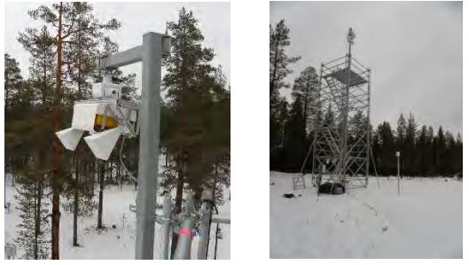
Water Cycle & Climate Change
            Water Cycle /Climate Linkage                         Clausius-Clapeyron Equation

• One of the Earth system’s major cycles
• The Clausius–Clapeyron equation governs the water-
holding capacity of the atmosphere that increases by
about 7% per degree Celsius.
Expectations: drizzles, storms, ET, speed of water
cycle, therefore, hydrological extreme events
                                                             Water in the climate system functions
               Application Linkage                            on all time scales (from hours to
                                                                           centuries)
Basic requirements for monitoring and prediction of
water resource, flood, drought, agricultures …..
                Key Science Questions
What are the spatial-temporal distribution characteristics
of water cycle components and processes? Are the
changing speeding up?
A Water Cycle Observation Mission WCOM - Jiancheng Shi Xiaolong Dong, Tianjie Zhao, Jiyang Du, Lingmei Jiang, Hao - GEWEX Events
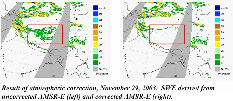
Available Sensors for Water
                                  Cycle
                                                                        Soil                     Sea       Sea
                                                                                Freeze
           Sensor       Frequency(GHz)       vapor   Preci.   Temp.   Moistur            SWE   Salinit   Surface
                                                                                 Thaw
                                                                          e                       y       wind
                     6.925;10.65;18.7;23.8
          AMSR-E                              √        √       √        √        √       √                 √
                           ;36.5;89
          GCOM/      6.9;7.3;10.65;18.7;23
                                              √        √       √        √        √       √                 √
          AMSR2           .8;36.5;89
          FY-3/      10.65;18.7;23.8;36.5;
                                              √        √       √        √                √
          MWRI                89
Multiple SMMR         6.6;10.7;18;21;37       √                √                 √       √                 √
Frequency
                     19.35;22.235;37.0;85.
Sensor    SSM/I                               √        √       √                 √       √                 √
                               5
                     10.65;19.35;21.3;37;8
          TRMM/TMI                                     √                                                   √
                              5.5
          WindSat    6.8;10.7;18.7;23.8;37    √        √                                                   √

                     19.35;22.235;37;50-60
          SSMIS                               √        √       √                         √                 √
                       ;91.655;150;183.31
          ASCAT             5.255                                                                          √
          ERS                5.3                                                                           √
Single    QuikSCAT           13.4                                                                          √
Frequency
          Aquarius          1.413                                                                √
Sensor
          SMOS               1.41                                       √                        √
          SMAP            1.26; 1.41                                    √        √
A Water Cycle Observation Mission WCOM - Jiancheng Shi Xiaolong Dong, Tianjie Zhao, Jiyang Du, Lingmei Jiang, Hao - GEWEX Events
Problems in SWE inversion
• Passive microwave(~25km):
    –   SMMR                 AMSR-E B04 product
    –   SSM/I                  (no pixel mixing
                                decomposition)
    –   AMSR-E
                                                                               5 0 .0 0

                                                                               4 0 .0 0

                             Our algorithm ( with
    –   AMSR2
                                                                               3 0 .0 0

                                pixel mixing                                   2 0 .0 0

    –   FY-3                   decomposition)                                  1 0 .0 0

                                                                                0 .0 0

                  (                     )
                                                                                          0   10   20   30   40   50

SD(SWE) = a + b ⋅ TBp (18) − TBp (37)
                                            4. Insufficient spatial resolution, horizontally
1. Semi-empirical algorithm:                in homogenous of snow (mixed pixel)
   Regional differences, inconsistent
   accuracy globally
2. Vertical inhomogeneous (layered
  snow), changes in snow
  characteristics
3. Atmospheres

                 Need: Spatial observation capacity
A Water Cycle Observation Mission WCOM - Jiancheng Shi Xiaolong Dong, Tianjie Zhao, Jiyang Du, Lingmei Jiang, Hao - GEWEX Events
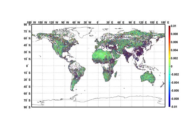
Problems of Current Techniques
1、Single-Frequency:             2、Multi-Frequency:                   3、Both: Lack of
Lack of synergistic             Lack of optimal                      systematical
                                                                     observations on the
observations on the other       frequency on the surface             characteristics the
affecting factors               water cycle components               water cycle
                       Disadvantages in
Parameters                                                Disadvantages in Inversion
                        Observations
                Weak penetration for high freq.; lack    Lack of valid inversion technique on
Soil Moisture    of temperature for low freq. ; RFI       vegetation and surface roughness
                  Low spatial resolution of passive      More considerations needed for snow
   SWE                      microwave                     process and atmosphere conditions
                 Low spatial resolution for passive         Limited validity for using fixed
     FT                    microwave                              Threshold values
                Lack of temperature and atmosphere
Sea Salinity               observations
                                                         Lack of surface roughness correction

   Sea          lack of simultaneous observations on    Uncertainties in the inversion of related
Evaporation       both sea surface and atmosphere                     parameters

   Precip.              Cloud 3D properties                 Need to Discern rain and snow
A Water Cycle Observation Mission WCOM - Jiancheng Shi Xiaolong Dong, Tianjie Zhao, Jiyang Du, Lingmei Jiang, Hao - GEWEX Events
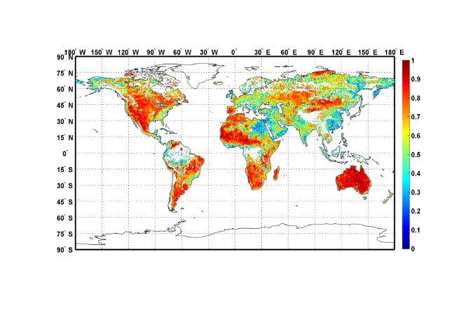
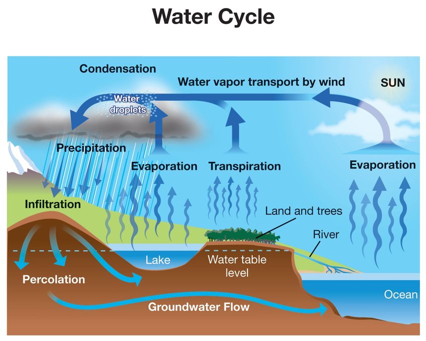
Payloads and Configurations
• 1. IMI,Full Polarized Interferometric Radiometer:
  Soil Moisture and Sea Salinity
• 2. DPS, Dual Frequency Polarized Scatterometer:SWE
  and FT
• 3. PMI, Polarimetric Microwave Imager, 6.8~89GHz:
  Temperature, rain, water vapor , atmosphere correction,
  and bridge to historical data

         Payloads                 IMI                PMI                     DPS
                       L, S ,C            C~W                         X, Ku
     Frequency(GHz)
                       (1.4,2.4,6.8)      (7.2,10.65,18.7,23.8,37,89) (9.6,14/17)
          Spatial
                     L: 50, S: 30, C:15   4~50(frequencies)          2~5(processed)
      Resolution(km)
     Swath Width(km) >1000                >1000                      >1000
       Polarization    Full-Pol           Full-Pol                   Full-Pol
        Sensitivity    0.1~0.2K           0.3~0.5K                   0.5dB
        Temporal
                     2~3                  2~3                        2~3
     Resolution(Day)
A Water Cycle Observation Mission WCOM - Jiancheng Shi Xiaolong Dong, Tianjie Zhao, Jiyang Du, Lingmei Jiang, Hao - GEWEX Events
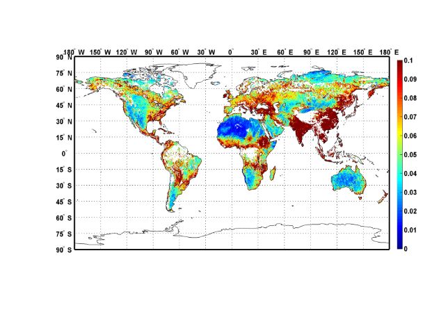
L/S/C Microwave Interferometric
                                                        Radiometer
                                                                                                                          system        1D Interferometry + parabolic cylinder
                                                                                                                                        reflector
                                                                                                                          frequency     L:1.4~1.427GHz,S:2.64~2.70GHz,
                                                                                                                                        C:6.6~6.9GHz
                                                                                                                          Sensitivity   L-band:0.1K;S-band:0.4K;C-band:
Instrument Concept:1D Microwave
                                                                                                                                        0.4K
  Interferometric Radiometer with
  parabolic cylinder reflector                                                                                            Polarization Full pol(H,V,Q,R)
  antenna                                                                                                                 A n t e n n a Reflector:6.0m×6.0m(after deployment)
•       Use parabolic cylinder reflector and                                                                              size          Feed array:4m×0.5m
        interferometric technology to achieve High
        spatial resolution                                                                                                FOV           >1000km
•       Patch feeds and shared reflector to achieve                                                                       Incidence     30~55º
        the multi-frequency ability
                                                                                                                          S p a t i a l L-band:50km,S-band:30km,C-
•       Dual-size feeds to enhance the system
        sensitivity performance                                                                                           resolution    band:15km
360
340                                                                                                                       revisit       2-3 days
320
300
280
                                                                                                                          weight        250kg
 -900   -800   -700   -600   -500   -400   -300   -200   -100   0   100   200   300   400   500   600   700   800   900

         Simulated footprints on the ground                                                                               Data rate     < 1Mbps
A Water Cycle Observation Mission WCOM - Jiancheng Shi Xiaolong Dong, Tianjie Zhao, Jiyang Du, Lingmei Jiang, Hao - GEWEX Events
Advantages in soil moisture retrieval

     RFI influence
                     Atmosphere                •     IMI
                        PMI
      FPIR-L&S                    Vegetation   1)Combination of L- and S-band can solve the
                                   correct     polarization effects in vegetation correction.
                                  FPIR-L&S
                                               2)The probability of RFI occurrence at the
        Surface effective
          temperature                          same area and frequency is vary small. RFI can
            PMI-Ka                             be avoid by switching L- and S-band .

                                                     • DPS
•     PMI : Surface effective temperature            Vegetation information of high resolution

                      PALS             Only L-band                      L+S-band
    SMEX02 experiment area

                                                   RMSE=0.047                      RMSE=0.035

    Various vegetation types
A Water Cycle Observation Mission WCOM - Jiancheng Shi Xiaolong Dong, Tianjie Zhao, Jiyang Du, Lingmei Jiang, Hao - GEWEX Events
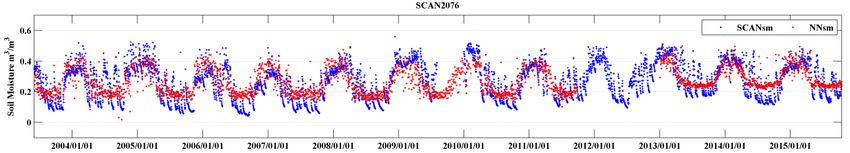
Soil moisture Products
                                                      Spectral analysis downscaling method for passive microwave
A) Passive microwave (IMI)
         Soil Moisture Active                                                                       V
  L/S/C-bands:   50/30/15
         and Passive (SMAP) km
  ExperimentMission
                  with Airborne             data:
  Downscale the L-band Tb (4km) at a
       scale of 800m using higher                                                                   H

    resolu7on Tb of S-band, and its
  valida7on with original L-band data
Passive:Sensi7ve to soil moisture but low resolu7on                       Downscaling using both active and passive
Ac7ve:High resolu7on but sensi7ve to vegeta7on and roughness

B)Active/passive microwave
(IMI/PMI+DPS)
                                            Ac7ve /passive
                    t
                    σ
                    vh
                        ⎛      σ vht ⎞ t   combina7on of C
        TBp = A + C t
                      + ⎜ B + D t ⎟ σ pp
                    σ
                    vh  ⎝      σ vh ⎠        and X band:                                   Observed Downscaled
                                                                               TBv~4km
                                                                                           (~0.8km)  (~0.8km)

  Products:Soil moisture estimates at a scale of both 15km and 5km over
  nominal areas and 30km over forests.                                                                             10
Advantages of WCOM Payloads
                           Design
                          IMI                          PMI                              DPS
                1 More sensitive to land
                surface                    1 Sensitive to temperature
Soil Moisture   2 Minimizing vegetation    2 Observing       large-scale 1
                                                                         2
                                                                           Surface Roughness and vegetation
                                                                           high resolution soil moisture
                effects                    surface roughness
                3 Mitigating RFI
                1 More sensitive to sea    1 effective correction on
                surface                    atmosphere
Sea Salinity    2 Faraday rotation                                       High resolution Wind Vector
                                           2 ensitive to sea temperature
                correction
S     e     a Corrections on sea surface
              roughness                  Sensitive to temperature        High resolution Wind Vector
Evaporation
                                                                1 Time series techniques for FT
                Obtaining Soil Surface Sensitive to temperature detection
FT              Parameters             changes                  2 Downscaling techniques for FT
                                                                inversion
                Obtaining Soil Surface Obtaining SWE by scattering 1 Estimating SWE
SWE             Parameters             effects                     2 Mitigating Mixed pixel effects

Vapor and  Helping determine land 1
                                  2
                                    )obtaining Water Vapor                High resolution observations on
          surface emissivity        )Precip. Rate                        precip.
Precip.                           3)Discerning Rain and snow

                          Vital                        major                            help

  The Payloads Design:1)Optimal channels for inversion,2)Effective corrections on
  affecting factors,3)Simultaneous observations
Objectives of WCOM

• Overall scientific objectives of WCOM
  • To significantly improve the accuracy and synchronization of measurements
    for spatial and temporal distribution of global water cycle key elements and
    system

  • To refine the long-term satellite observations over past decades, and to
    provide a new opportunity to improve water cycle related model.
2014-2016 Objectives

              Science part                           Technology part
1)Further evaluation of science objectives;    1)Design and evaluation of
further optimization of payloads, to achieve   payloads: FPIR, PMI and DFPSCAT
higher precision water cycle parameters
observation than any existing satellites;      2)To make breakthroughs in key
                                               technologies in payloads, and the
2)Based on the simultaneously multi-           experimental validation of the key
sensor observation, to achieve joint key       technologies ;
water cycle parameters and environmental
parameters retrieval, and the preliminary      3)WCOM satellite platform design
algorithm validation;                          and evaluation based on the
                                               requirement of payloads and their
3)The study of the method to calibration of    observation; Design and evaluation
historical observations of other satellites    of interface between satellite system
based on WCOM observations; Water cycle        and other systems
models parameter optimization;
Scientific Application System
1) Subsystem of Joint Retrieval        L1 data            Scien7fic objec7ve 1:
        and Validation
                                                          spatial or       Spatial
                                                          temporal
     Retrieved high accuracy         L2/L3 data                            and
                                                       distributions of
   scientific products of major                         current water      Temporal
     water cycle components                              cycle system      Patterns
                                                                           and
                                   Historical              spatial or      Trends of
       2) Subsystem for           observations             temporal
                                                                           the
        historical data                                  variations of
         reprocessing                 L4 data           water cycle in a   Water
                                                       long-term period    Cycle

       Long-term remote                           Scien7fic objec7ve 2:
    sensing data products of
    water cycle components                Parameter
                                       optimization and               Responses of
                                                                     Water Cycle to
  3) Subsystem for Modeling             refinement of
                                         hydrological                Global Change
   and Data Assimilation of
                                                                    and Its Feedback
         Water Cycle                        models
WCOM data processing Structure

                                          Calibration

    WCOM                                   L1 dataset
 Ground System
                                 Atmospheric correction
Design and test the
porotype algorithms
                         IMI                  PMI                DPS
for snow water
equivalent, soil
moisture, soil freeze/                   Joint Retrieval
thaw, ocean salinity,                                 L2/L3 datasets
atmosphere water         Soil Moisture               Ocean salinity
vapor and
                         Snow water
precipitation.            equivalent                Soil freeze/thaw

                           Ocean                    Water vapor and
                         evaporation                 precipitation
SWE retrieval and Validation
SWE inversion algorithm for
DPS scatterometer is
developed based on
                               2009-2010 Winter
Bicontinuous+VRT model .

 Three-year time series
measurements at dual-
polarization X and Ku bands
in Finland Nosrex campaign.   2010-2011 Winter

                              2011-2012 Winter
WCOM data simulator
                       Dynamic forcing data module
      WCOM payloads                              Land/Ocean/Atmosphere radiative
       configuration                             transfer and backscatter modelling
                          1. FPIR/PMI Brightness temperature
                          2. DFPSCAT Backscatter coefficient
DPS

                                                       Satellite orbit, Sensor gain
                                                        function, footprints and
                                                                resampling
                             Initial WCOM data
                                                       Calibration with current
IMI

                                                       satellites (SMOS/SMAP,
                                                              AMSR2, etc)
                            Final WCOM data
                                                                  2) Evaluate
                                                              instrument error on
                                                             science requirements
PMI

                            3) Parameter
                           optimization of             1)Retrieval algorithm
                          hydrologic model           development and validation
Establishments of Historical Data
Improving the algorithms using the                       Form long time
accurate WCOM measurements                               series
                                                         measurements to
                      SWE        WCOM          F/T
                                                         analyze the
                            Soil Moisture                change
                                                         characteristics
                                    AMSR-E
     风云3号微波辐射计

                                                              ASCAT 1-3
                                                              on METOP
        5 频率(10.7-87 GHz)             6 频率(6.9-89 GHz)        Series

TMI/TRMM 1998-GPM                           ERS + ASCAT 1991-Now
SSM/I(R): 1978 – Now                        Combined Passive/Active
Test from SMOS-AMSR-E
    • input:SMOS soil moisture and AMSR-E observations;
    • output:simulated SMOS soil moisture with AMSR-E.

                                                                                                    R

         2003   2004   2005   2006   2007   2008   2009   2010   2011   2012   2013   2014   2015

1                                                                                                   SD

                                                                                                    BIAS
Model parameter optimization using
                systematic satellite observations
 1、Parameter optimization using single-element observation
                                                         Changes in model performances
            Case                   Soil
                                                    Soil moisture       Sensible heat flux   Latent heat flux
                                temperature
soil temperature observation      21.99%              -41.87%                11.13%             -46.08%
  Soil moisture observation         -0.46%            10.85%             1.15%                 1.29%
Test experiments by CoLM demonstrate that: the model error will transfer to another state variables when only
one state is optimized by using single-element observation

2、 Parameter optimization using multi-element observation
  Parameter Selection                Building Surrogate Models
    Select the most sensitive        Building statistical models to             Multi-Object Optimization
   and controlling parameters        surrogate the physical models

        ASMO:higher efficiency                  SCE-UA:lower efficiency
                                                                          Simultaneous multi-
                                                                          parameters optimization
                                                                          provide a much better
                                                                          chance for the model
                                                                          improvement
International Collaborations
                      WCOM,SMOS,SMAP
         FY-3 Preci
                                             GPM
            Sat

                      Global Water Cycle
                         Observa7ons
WCOM
         Ocean Salinity,
         Water Resource                    SWOT,
             Sat(s)                        GRACE

 Form a global water cycle consolidation
Water Cycle Observation Mission
             (WCOM) Summary
                          Systematic and Simultaneous
                          Observations For Water Cycle
       Accurate
     Inversion of
                           Soil Moisture                                Key Science
     Water Cycle                                      1) Accurate
     Parameters
                                                                         Questions:
                               Freeze/Thaw                key            1) Improving on
       based on                                      components
W     Synergistic                 SWE               measurement;
                                                                        understanding of
                                                                         spatial/temporal
C    Observations
                           Ocean Salinity             2) Improve            distribution
O                                                      historical    characteristics of water
                                                    measurements      cycle key parameters
M                              Precipitation
                                                         and to        and related physical
      New Payloads               Ocean              Improving the            processes?
        Designs                Evaporation          related models
                                                                         2) Response and
                                                                     feedback of water cycle
                                                                        to global changes?
                                                  Science and
    Demand and feasibility
                                                 measurements
    analysis for the sensors
                                               current drawbacks
You can also read