An Overview of Flood Resilience: A case of Surat City - International Journal of ...
←
→
Page content transcription
If your browser does not render page correctly, please read the page content below
International Journal of Management, Technology And Engineering                                                   ISSN NO : 2249-7455

               An Overview of Flood Resilience: A case of Surat City
                                          Kashyap A. Patel1, Sejal S. Bhagat2
               1
                   Post Graduate Student, Town and Country Planning, Sarvajanik College of Engineering and
                                                Technology (Surat, Gujarat)
                   2
                       Assistant Professor, Faculty of Civil Engineering, Sarvajanik College of Engineering and
                                                    Technology (Surat, Gujarat)

           ABSTRACT
           Resilience is the ability of individuals, communities, organizations and states to adapt and recover from
           hazards, shocks or stresses without compromising long-term prospects for development. Disaster resilience
           programming aims to save lives, protecting infrastructure, livelihoods, social systems and the environment
           (Cabot Venton et al., 2013; Turnbull et al., 2013). River Tapi is originating from a Multai Hills (Gavilgadh hill
           ranges of Satpura) and flowing through three states Maharastra, Madya Pradesh and Gujarat having length of
           725 Kms. The flow of water and water level in the river Tapi is controlled at Ukai am which is 100 kms away
           from Surat city. The major purposes of the dam being essentially irrigation, power generation and partial flood
           control. Major floods occur in the year of 1968 and 2006. floods of August 2006 remained devastating for
           Surat in terms of the extent of damage, during which nearly 75% of the city was inundated. Surat city faced
           huge amount of life ,property loss also infrastructure that cost crores of rupees. Hence, some preventive
           measures are crucially required or we can say there must be need of improving resilience of the city to
           withstand or reduce the diverse effects of flooding. This paper address some possible and suggestive measures
           to overcome this issues and challengesthat can be very crucial for improvement of resilience of the surat city
           against floods.

           Keywords-Resilience, Flooding,River Tapi, Preventive measures.
           1. Introduction
           The combination of climate change and increasing urbanization brings great challenges to planning and
           managing cities for sustainability. Recent studies show that climate change is very likely to alter the
           hydrological cycle in many regions, causing a higher probability of extreme weather events such as droughts
           and floods (Bates et al., 2008). In a recent report on natural disasters (UNISDR, CRED, 2015), the United
           Nations pointed out that 43% of them, in the period between 1995 and 2015 were related to floods. These event
           affected more than half (56%) of all people who suffered from any type of natural disaster, kill ing about a
           quarter of them (26%).
           In many parts of the world, the intense urbanization process and rapid growth of the cities has led to the
           emergence of so-called mega cities, which are especially sensitive due to major land use changes and resource
           consumption. Mega cities, especially in late urbanization countries, tend to be densely populated, with many
           areas that have grown fast, often with insufficient infrastructure, resulting in environmental degradation and
           greater flooding. Mostly in river flood is problem from which economy and culture of city to be distracted so it
           is necessary to analyze the flood on river and forecast the flooding condition on river. Flood inundation is the
           process in which we have to inundate or analyze flood in particular region of river so it is easy to prevent future
           flood condition and also precaution against hazardous condition.

Volume IX, Issue I, JANUARY/2019                                                                                           Page No: 3043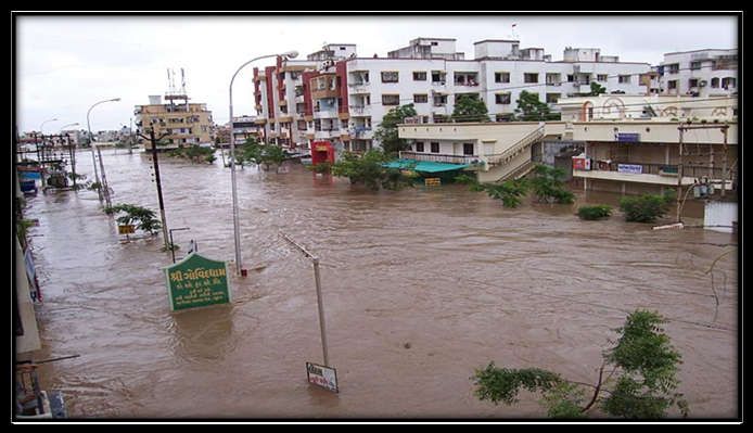
International Journal of Management, Technology And Engineering ISSN NO : 2249-7455
Flood Resilience
Resilience is the ability of individuals, communities, organizations and states to adapt and recover from hazards,
shocks or stresses without compromising long-term prospects for development. Resilience is the capacity of
individuals, communities, businesses, and systems within a city to survive, adapt, and grow, no matter what
kinds of chronic stresses and acute shocks they experience.(Surat Resilience Strategy,April 2017)
Benefits of Disaster Resilience
Disaster resilience programming aims to save lives, protecting infrastructure, livelihoods, social systems and the
environment (Cabot Venton et al., 2013; Turnbull et al., 2013).
Potential contribution of Disaster resilience can be,
Saving lives
Protecting infrastructure and livelihoods
Protecting social systems
Protecting the environment
Supporting broader resilience in contexts of violent conflicts or fragile states.
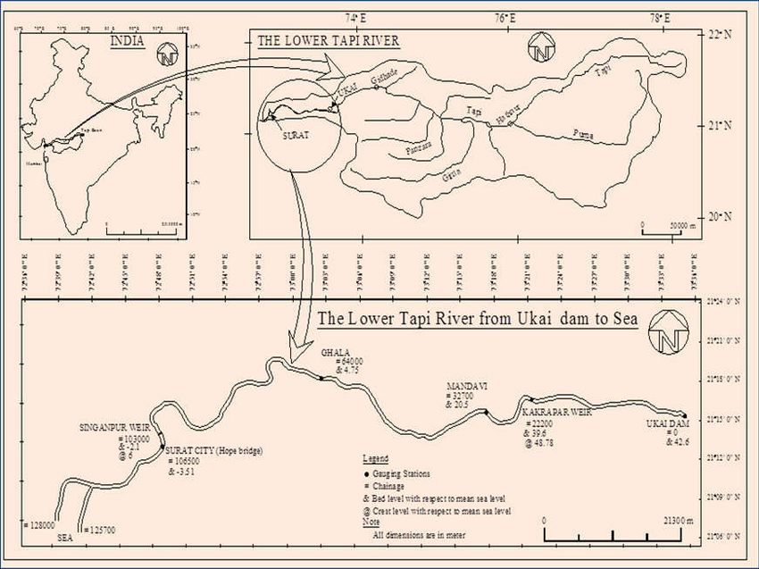
2. Study Area
River Tapi is originating from a Multai Hills (Gavilgadh hill ranges of Satpura) and flowing through three states
Maharastra, Madya Pradesh and Gujarat having length of 725 Kms. The flow of water and water level in the
river Tapi is controlled at Ukai am which is 100 kms away from Surat city. The foundation of dam is resting on
Dolerite dykes (Basalt). It is constructed for irrigation purpose mainly and also served the purpose of flood
control, generation of hydropower and supply of industrial and drinking water. The average rainfall in the
catchment area is about 785 mm and average yearly run off is 17,226 MCM. The area of Surat city situated at
delta stage of the river is 326.51 sq.km. and population is about 40 lacs. The city is having 60,000 Shops &
Establishment in trading activity. The city is also famous for diamond industry. The Major industries like Essar
Steel, Reliance, ONGC, L & T, Gail, Kribhco, Shell, NTPC, GSPC, Torrent Power etc. are situated in the city.
The study area is shown in Fig. No.1. Floods are occurring in river Tapi time to time, due to which major
portion of the city is submerged creating lot of damage in residential as well as industrial areas. There is a need
of reducing the effect of flood. In this paper the aspects of river channel modification are considered for
enhancing the carrying capacity and reducing the effect of flood in the city.
7%
Water bodies
of total 326 sq.
km .
Volume IX, Issue I, JANUARY/2019 Page No: 3044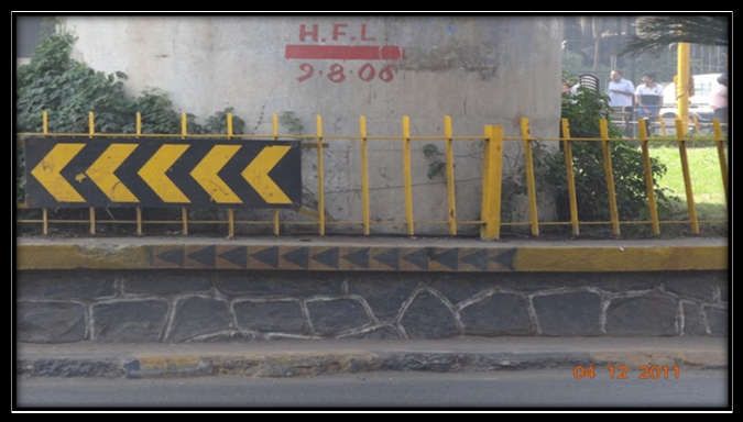
International Journal of Management, Technology And Engineering                                                  ISSN NO : 2249-7455

                                  Figure 1 Tapi River within Surat City (Source-BISAG,Gandhinaga

                                                  Figure 2 Tapi Basin (Source-SMC)

           Surat, previously known as Suryapur, is a city in the Indian state of Gujarat. Surat - the modern port city of
           today boasts of a great historical and cultural heritage. Surat of today has earned the reputation of an important
           industrial hub and commercial center of the country Diamond City": Surat is well known for its Diamond
           business. “Silk City" : Surat is also known as "Textile city".

           Demographic Profile
                                               Table 1Democratic Profile Table of Surat City

            Sr. No.      Name of Zone         Area (km2)                    Totalpopulation                 Total house
                                                                                                                hold
                                                                      2001                    2011

               1          Central Zone           08.18              413641                408760               74679

               2           North Zone            36.363             416370                705163               82775

               3            East Zone            37.525             711516               1137138              143574

               4           South East            19.492             397257                748304               81999
                              Zone

               5           South zone            61.764             407980                695028               94582

               6           South-west           111.912             242466                347447               50236
                              zone

Volume IX, Issue I, JANUARY/2019                                                                                          Page No: 3045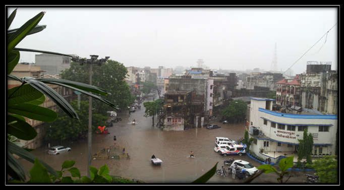
International Journal of Management, Technology And Engineering                                                  ISSN NO : 2249-7455

               7           West Zone                51.29           287144               424986                57687

                        Total                   326.515            2876374              4466826                585532

                                                                                                           (Source-SMC)
           History of Flooding in Surat and the Reasons
           Since 1869 up to 1884, on an average, the city was flooded every two and half years followed by a fall in its
           frequency by 1914. During 1949 to 1979, the average natural flood occurrence was once in every four years.
           With this in mind, the Ukai dam, located about 100 km upstream of Surat, was completed in 1972. The major
           purposes of the dam being essentially irrigation, power generation and partial flood control. However, heavy
           Rainfall in the catchment area of Ukai Dam in the upstream (mainly in Maharashtra) which leads to heavy
           inflow in the Ukai Dam has often resulted in heavy discharge of water from the Ukai Dam, responsible for
           flooding in Surat in the past 20 years. This is largely caused by the competing objectives of the Ukai dam, which
           designed mainly for irrigation and power generation with partial flood control. To meet the first two objectives,
           the dam has to be able to hold as much water as possible leaving a limited cushion for flood control, especially
           during the later parts of the monsoon.

           .
                             Figure 3 Digital elevation modelling image showing low lying area of surat city

           The floods of 1998, 2004 and 2006 occurred following emergency discharges from Ukai dam. Out of these
           years, floods of August 2006 remained devastating for Surat in terms of the extent of damage, during which
           nearly 75% of the city was inundated. Anthropogenic changes including building of bridges, embankments and
           the Singanpore weir have reportedly increased the siltation and reduced the carrying capacity of the river
           channel, as evident from the increasing flood levels for the similar amount of the discharge over last few
           decades (Flood Risk Management Study, Centre for Social Studies. 2009).
           Types of Floods in Surat- floods due to the Ukai dam & the Khadi
           Flooding due to Ukai Dam:
           The floods in August 2006 were primarily due to the discharge of water from the Ukai dam in a very short span.
           The Tapi River within embankments can safely discharge about 8,495 cubic meter per sec (0.3 million cusecs).

Volume IX, Issue I, JANUARY/2019                                                                                         Page No: 3046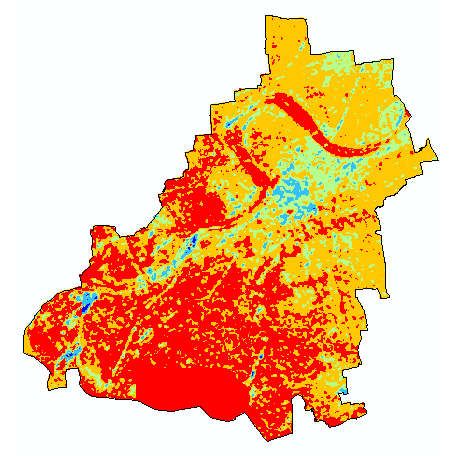
International Journal of Management, Technology And Engineering                                                ISSN NO : 2249-7455

           Khadi Floods- The second type of flood is caused by the two streams passing through the city. These floods are
           more frequent but cause comparatively less damage. While not causing severe impacts now, the Khadi floods
           can be expected to impact significant sections of population living on the stream banks. With the change in
           future tidal conditions and increased population growth along (especially poorer sections of the population)
           along the tidal creaks will be at a high risk.
                                                     Table 2 Flood Events at Surat city

                                             Discharge
              Sr         Flood                                                                               Period
                                            (Lac Cusecs)             Water Level at Hop Bridge (m)
                         Event
             no.

              1          1883                   10.05                                 11.05                    July

              2          1884                    8.46                                 10.05                September

              3          1894                    8.01                                 10.33                    July

              4          1942                    8.60                                 10.56                  August

              5          1944                   11.84                                 11.32                  August

              6          1945                   10.24                                 11.09                  August

              7          1949                    8.42                                 10.49                September

              8          1959                   12.94                                 11.55                September

              9          1968                    15.5                                 12.08                  August

             10          1994                    5.25                                 10.10                Aug.-Sept.

             11          1998                    7.0                                  11.40                September

             12          2006                    9.09                                 12.40                  August
                                                                                                 (Source-Flood Cell,Surat)
           Scenario of Flood during August 2006
                                                                                                                             st
           The flood occurred in the year 2006 was devastating. The level of water started rising in the river Tapi from 1
                                                                                 th      th
           August 2006 and started spreading in the nearby area of city. By 5 to 9 August 2006, almost 90% area of the
           city was flooded and the depth of flood water observed in the different areas was varying according to the
           topography of the City. The information and warning about flood must be reached to the people timely so that
           the people can take their own measures of safety and precautions. Figure 2 shows the status of warning in Surat
           during flood 2006. From the figure, it is evident that about 43% of people did not receive any warning from the
           Surat Municipal Corporation (SMC) or any other state agency. They learnt about the approaching flood only
           when they saw the water rising. This proportion was highest (64%) in areas like Citylight, Umra and Piplod, all
           of which are considered Surat’s posh or upcoming localities. Only around 7% of respondents said that they had
           received some warning from the administration through vans or Short Service Messages (SMS) on mobile
           phones.

Volume IX, Issue I, JANUARY/2019                                                                                        Page No: 3047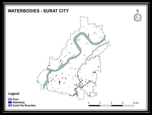
International Journal of Management, Technology And Engineering                         ISSN NO : 2249-7455

                                     Figure 4 Flood water level at area of Surat city

                                          Figure 5 Flooded Area of Surat City

Volume IX, Issue I, JANUARY/2019                                                              Page No: 3048
International Journal of Management, Technology And Engineering ISSN NO : 2249-7455
3. Recommendations
Below listed some flood prevention measures that can reduce the flooding effects as well as improves the
resilience of the city.
Construction of artificial Reservoirs
Land use control
• Spatial Planning Flood risk adapted land use
• Building regulations
• Building codes
• zoning ordinances
Construction of Embankments/ protection wall
Channel Improvement
Drainage Improvement
Diversion of Flood Waters
Watershed Management
Increasing the carrying capacity of river
Channel Dredging
4. Conclusion
Surat city (India) situated at the tail end of river Tapi is subjected to moderate to heavy floods frequently
due to heavy rainfall in the catchment area. Study of floods at Surat city has been made in this paper. To
minimize the effect of flood at Surat city, certain preventative measures have been suggested.
5. References
I. Surat resilience strategy,2011 & 2017
II. Urban flood resilience – a multi-criteria index to integrate flood resilience into urban planning-
Louise Bertilsson, Karin Wiklund, Isadora de Moura Tebaldi, Osvaldo Moura Rezende, Aline
Pires Veról, Marcelo Gomes Miguez
III. Preparation of Flood Reduction Plan For Surat City And Surrounding Region (India) Rasit G.
Agnihotri, Lecturer
IV. Surat resilience strategy,2011 & 2017
V. Identifying Probable Submergence Area of Surat City Using Digital Elevation Model and
Geographical Information System-Dhruvesh P. Patel, Mrugen B. Dholakia
VI. Surat 2006 floods: a citizen’s report..
Volume IX, Issue I, JANUARY/2019 Page No: 3049You can also read