Anthropogenic climate change and glacier lake outburst flood risk: local and global drivers and responsibilities for the case of lake Palcacocha ...
←
→
Page content transcription
If your browser does not render page correctly, please read the page content below
Nat. Hazards Earth Syst. Sci., 20, 2175–2193, 2020
https://doi.org/10.5194/nhess-20-2175-2020
© Author(s) 2020. This work is distributed under
the Creative Commons Attribution 4.0 License.

Anthropogenic climate change and glacier lake outburst flood risk:
local and global drivers and responsibilities for the case
of lake Palcacocha, Peru
Christian Huggel1 , Mark Carey2 , Adam Emmer3 , Holger Frey1 , Noah Walker-Crawford4 , and
Ivo Wallimann-Helmer5
1 Department  of Geography, University of Zurich, Winterthurerstrasse 190, Zurich, Switzerland
2 Robert D. Clark Honors College and Environmental Studies Program, University of Oregon, Eugene, USA
3 Global Change Research Institute, The Czech Academy of Science, 603 00 Brno, Czech Republic
4 Department of Social Anthropology, Manchester University, Manchester, UK
5 University of Fribourg Environmental Sciences and Humanities Institute, Fribourg, Switzerland

Correspondence: Christian Huggel (christian.huggel@geo.uzh.ch)

Received: 12 February 2020 – Discussion started: 26 February 2020
Revised: 17 June 2020 – Accepted: 24 June 2020 – Published: 13 August 2020

Abstract. Evidence of observed negative impacts on natural         commit to support strengthening capacities in affected re-
and human systems from anthropogenic climate change is in-         gions and localities and that local institutions and societies
creasing. However, human systems in particular are dynamic         engage in local risk reduction measures and policies in col-
and influenced by multiple drivers and hence identifying an        laboration with and driven by local communities.
anthropogenic climate signal is challenging.
   Here we analyze the case of lake Palcacocha in the An-
des of Peru, which offers a representative model for other
glacier lakes and related risks around the world because it
features a dynamic evolution of flood risk driven by physical      1   Introduction
and socioeconomic factors and processes. Furthermore, it is
the object of a prominent climate litigation case, wherein a       Impacts of climate change are increasingly observed in many
local Peruvian citizen sued a large German energy producer         natural and human systems worldwide (Cramer et al., 2014;
over risk of flooding from lake Palcacocha.                        Hoegh-Guldberg et al., 2018). Shrinking glaciers are among
   Adopting a conceptual model of cascading impacts and            the most visible indicators of climate change, as the mountain
multiple drivers of risk, we first study climatic and other geo-   cryosphere is especially prone to warming (Dussaillant et al.,
physical drivers of flood risk. We find that an anthropogenic      2019; Hock et al., 2019; Zemp et al., 2015). While glaciers
signal from flood risk to greenhouse gas emissions is trace-       are widely monitored from the ground and from space, the
able. In parallel, flood risk has been strongly shaped (and in-    impacts of glacier changes on natural and human systems
creased) by interacting socioeconomic, institutional and cul-      are often more difficult to observe, and attribution of the ob-
tural processes over the past few decades.                         served changes to causal factors can be challenging (Carey
   The case raises important questions about the differenti-       et al., 2017; Hansen and Stone, 2016; Huggel et al., 2016).
ation of responsibilities relating to flood risk of both global    Changes in water resources and natural hazards are thereby
and local agents, which are, however, difficult to address in      the most substantial effects and have been documented in
cases like Palcacocha, where we reveal a complex network of        many mountain regions of the world (Casassa et al., 2009;
interlinked global, national and local drivers. Following from     Cramer et al., 2014; Harrison et al., 2018). Glacier lake out-
this, we outline a normative framework with a differentiated       burst floods (GLOF) are among the most destructive and far-
perspective on responsibility, implying that global emitters       reaching hazards related to glacier changes and have killed

Published by Copernicus Publications on behalf of the European Geosciences Union.
2176                                   C. Huggel et al.: Anthropogenic climate change and glacier lake outburst flood risk

thousands of people in single events (Carey, 2005; Carrivick
and Tweed, 2016).
   Glaciers will continue to shrink and impact downstream
natural and human systems in the coming decades, although
emission pathways will have a crucial effect on the extent of
the process and impacts (Hock et al., 2019; Huss and Hock,
2018; Kraaijenbrink et al., 2017; Schauwecker et al., 2017).
Adaptation to cryosphere impacts is of fundamental impor-
tance and has so far taken place in the majority of countries
(McDowell et al., 2019). Recent research has emphasized
the importance of comprehensively understanding adapta-
tion around socio-cryospheric and socio-hydrologic systems,
with accumulating evidence from the Himalayas (Mukherji
et al., 2019), including Ladakh (Nüsser et al., 2019; Nüsser
and Baghel, 2016) and Tsho Rolpa, Nepal (Sherry et al.,
2018); the Andes (Carey et al., 2014); and comparative anal-
yses (Orlove et al., 2019). Some of this research has pointed
to adaptation to cryosphere change potentially reaching cer-
tain limits, e.g., with the disappearance of glaciers in regions
that are highly dependent on glacier meltwater or large slope      Figure 1. Study region with lake Palcacocha and the city of Huaraz
                                                                   (source: SPOT image; year of acquisition: 2006).
instabilities making certain areas uninhabitable or existing
livelihood strategies unviable, thus resulting in losses and
damages (Huggel et al., 2019). Loss and damage (L&D) as
a concept in global climate policy has been defined as the
impacts that cannot or have not been avoided through miti-
gation and adaptation (Okereke et al., 2014; Warner and van        and vulnerability of people and assets (IPCC, 2014). Lake
der Geest, 2013), but there is still missing clarity and de-       Palcacocha offers a representative case for other glacier lakes
bate about what L&D comprises (Calliari, 2018; Lees, 2017;         and related risks around the world because it features many
Mechler et al., 2019). In the Paris Agreement, L&D was an-         physical and social dynamics found elsewhere: a shrink-
chored in a separate article, but at the same time the agree-      ing glacier that led to the formation of a large glacier lake
ment specifies that this article does not provide any basis for    where ice previously existed; continued lake instability due
liability and compensation.                                        to glacier retreat and moraine dam instability; a past glacier
   Despite this disclaimer at the level of international pol-      lake outburst flood that killed thousands of local residents
icy, important questions of responsibility and justice emerge      and partially destroyed a city and other communities and in-
from negative effects and risks related to climate change in       frastructure; repeated flood prevention and lake drainage en-
general and to the mountain cryosphere specifically, such          gineering works; a history of glacier lake monitoring and on-
as which natural and social processes can be identified as         going scientific studies; contested knowledge, science, and
drivers of risk; to what extent are global greenhouse gas emit-    perceptions about the lake and its risks among experts, pol-
ters contributing to these risks; who must be held accountable     icymakers, local residents, and other groups; a complex po-
to reduce local loss of lives and goods; and under what cir-       litical and institutional context with periods of increased at-
cumstances are local people, institutions, and governments         tention and neglect of the problem by authorities and the lo-
able to manage these risks? There is currently only limited        cal population; unclear responsibilities among different gov-
research that offers evidence for and responses to these ques-     ernment agencies and levels; and, overall, a dynamic evolu-
tions. In this paper, we analyze these aspects from different      tion of risk driven by physical and socioeconomic factors and
disciplinary perspectives and associate them with a norma-         processes. Our objective is to analyze to what extent we can
tive responsibility framework to identify responsibilities for     identify natural and social processes as factors and drivers of
action.                                                            risk at lake Palcacocha and in Huaraz and to discuss whether
   This paper focuses on the glacier lake Palcacocha and as-       this analysis can inform the conceptualization of responsi-
sociated flood risk for the downstream city of Huaraz in the       bilities related to managing the negative impacts of anthro-
Peruvian Andes (Fig. 1) to help answer these questions in          pogenic climate change.
a specific context and to offer larger insights into climate           This analysis is timely not only because glacierized moun-
change risks and responsibilities. While being attentive to        tain regions are increasingly grappling with unstable glacier
a diversity of risk frameworks and concepts (Blaikie et al.,       lakes but also because lake Palcacocha recently made head-
1994; Oliver-Smith, 2013; Wisner et al., 2004), we under-          lines worldwide because of a legal case, Saúl Luciano Lliuya
stand risk as a function of physical hazard, human exposure        vs. RWE (Frank et al., 2019). This case, pending at a Ger-

Nat. Hazards Earth Syst. Sci., 20, 2175–2193, 2020                                 https://doi.org/10.5194/nhess-20-2175-2020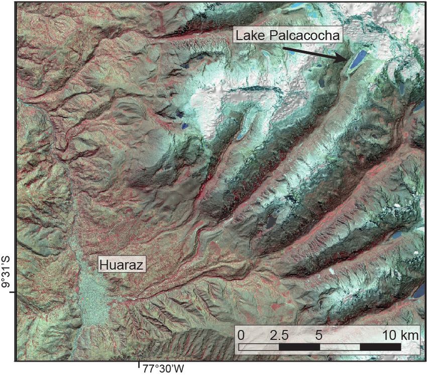
C. Huggel et al.: Anthropogenic climate change and glacier lake outburst flood risk                                           2177

man court, 1 emerged when a local resident of Huaraz (Lu-           in institutional, urban, and rural settings, as well as inter-
ciano Lliuya), sued the German energy producer RWE over             views with people from these three spaces.
flood risk from glacier lake Palcacocha, threatening his prop-         This case demonstrates the inherent links between local
erty if the lake were to cause a flood. Luciano Lliuya argues       and global activities to manage climate risks and how they
that Palcacocha is unstable as a result of anthropogenic emis-      drive localized climate-related risks. The local–global link-
sions (to which, he alleges, RWE made a significant contri-         ages raise many questions about causality, liability, respon-
bution), which caused glacier retreat and the growth of lake        sibility and justice (Sect. 7). Our assumption is that a better
Palcacocha, making the lake unstable and threatening down-          understanding of the diverse drivers of risk in a case like Pal-
stream communities. The case was initially dismissed at a           cacocha allows us to clarify the differentiation of responsi-
local German court but then admitted by a higher appeals            bilities and the challenges ahead vis-à-vis impacts and risks
court. As the first lawsuit of its kind to reach this stage, it     of loss and damage.
was considered a significant breakthrough in climate litiga-
tion (Ganguly et al., 2018; Huggel et al., 2016). Although the
literature on climate litigation is steadily growing (Marjanac
and Patton, 2018; McCormick et al., 2018), questions of re-         2   Lake Palcacocha
sponsibility, and possibly liability, in a case like Palcacocha,
remain mostly unanswered and hence call for studies that an-        The evolution and history of lake Palcacocha in Peru’s
alyze risk and responsibility during climatic, cryospheric and      Cordillera Blanca is linked to glacier retreat, driven by both
societal change. The purpose of this paper, however, is not         natural and anthropogenic forcing, large flood disasters, and
to analyze legally relevant questions of causality but rather       human intervention and flood mitigation at the lake (see Ta-
to substantiate and situate the Palcacocha case in a broader        ble 1). According to the lichenometric dating, the moraine
context and within the concept of responsibility.                   that later dammed the lake developed between 1590 and 1630
   To achieve a comprehensive picture of flood risk in Huaraz       (Emmer, 2017) due to advancing glaciers from the south-
and its relation to climate and socioeconomic change, we            western slopes of Palcaraju (6274 m a.s.l.) and Pucaranra
make use of existing data and information and conduct addi-         (6156 m a.s.l.) mountains. This period corresponds to the be-
tional research where needed, including hazard field studies,       ginning of the first, more distinct, phase of the LIA in the
numerical flood modeling, satellite data analysis, census data      Cordillera Blanca (Thompson et al., 2000; Solomina et al.,
and interviews. We structure our paper as follows: we first an-     2007). It is not known precisely when the lake formed; how-
alyze the physical evolution of lake Palcacocha from the mid-       ever, based on the available evidence we estimate that it was
19th century Little Ice Age (LIA) to the present (Sect. 2).         likely after the second phase of the LIA in the second half
We then disentangle the different drivers of GLOF risks fol-        of 19th century. The Palcacocha drainage outlet nourishes
lowing the aforementioned IPCC-based risk concept. We be-           the Paria river, joins other waterways downvalley and flows
gin with the physical hazard component of risk, studying            into the Quillcay River that runs through downtown Huaraz,
how global drivers of anthropogenic greenhouse gas emis-            the capital city of Peru’s Ancash Region, with approximately
sions affect the local conditions of GLOF hazard (Sect. 3).         140 000 inhabitants today.
We collected remote sensing and fieldwork-based informa-               The first scientific expeditions and observations of the lake
tion to document the evolution of lake Palcacocha. We ana-          were undertaken by Austrian and German researchers led by
lyzed the hazard conditions at and around the lake to develop       Hans Kinzl in the late 1930s, a time before anyone realized
a number of flood scenarios that we then implemented in             the threat that Palcacocha posed to downstream communities
a physically based GLOF flow model following established            (Carey, 2012; Portocarrero, 2014; Wegner, 2014). Shortly af-
methodologies to evaluate the downstream hazard in Huaraz.          ter, on 13 December 1941, lake Palcacocha’s moraine dam
We then look at how social, economic, institutional and cul-        failed, resulting in a GLOF with a volume of >10 million
tural aspects become drivers of risk exposure and vulnerabil-       cubic meters and peak discharge in excess of 10 000 m3 s−1 ,
ity (Sects. 4–6). For this purpose, we used a mixed methods         causing devastating impacts on the city of Huaraz, located ca.
approach to elucidate various environmental and sociocul-           25 km downstream of the lake (Mergili et al., 2020; Somos-
tural drivers that contribute to risk. Our historical analysis of   Valenzuela et al., 2016). The flood killed nearly 2000 peo-
risk development in Huaraz derives primarily from histori-          ple and destroyed one-third of the city of Huaraz, focused
cal document analysis, literature review and interviews with        particularly in its most developed downtown area and mod-
contemporaneous figures. The more recent analysis of socio-         ern commercial district (Carey, 2010; Wegner, 2014). This
cultural and institutional factors contributing to risk (since      event is considered among the worst floods ever documented
2009) draws on qualitative data from participant observation        worldwide resulting from natural dam failure (Carrivick and
                                                                    Tweed, 2016; Costa and Schuster, 1988). Although the pre-
                                                                    cise cause is not known, the 1941 flood likely followed an
  1 Saúl Ananías Luciano Lliuya vs. RWE AG, Oberlandesgericht       impact of an ice avalanche into the lake or failure related to
Hamm, Az.: I-5 U 15/17.                                             piping in the dam (Oppenheim, 1946).

https://doi.org/10.5194/nhess-20-2175-2020                                 Nat. Hazards Earth Syst. Sci., 20, 2175–2193, 2020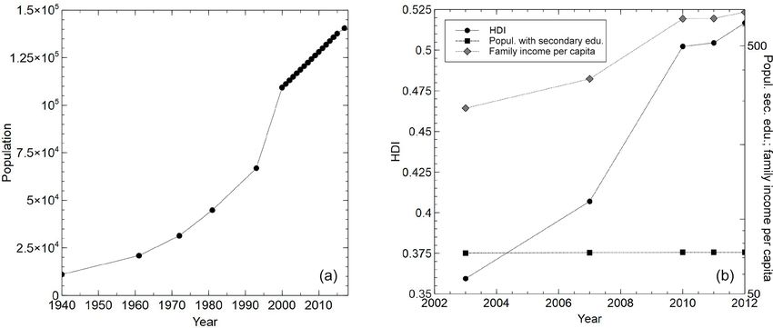
2178                                      C. Huggel et al.: Anthropogenic climate change and glacier lake outburst flood risk

Table 1. Milestones in the evolution of lake Palcacocha.

       Period/date          Milestone                        Details                                       Reference
       1590–1630            Glacier advance and formation    Formation of the moraine that (later)         Emmer (2017)
                            of the moraine                   dammed the lake.
       Late 1930s           European expeditions to the      Hans Kinzl visited Palcacocha and             Byers (2000),
                            lake and the first photographs   other Cordillera Blanca glaciers and          Carey (2012),
                                                             glacier lakes (1939).                         Wegner (2014)
       13 December 1941     Dam failure and GLOF             See main text.                                Carey (2010),
                                                                                                           Oppenheim (1946)
       1950s–1960s          Lake stagnation                  1942: clearance of drainage canal to fa-      Air photographs;
                                                             cilitate drainage.                            Carey (2010)
                                                             1950s: construction of a security dam
                                                             with a drainage canal at its base to pre-
                                                             vent rising lake levels. Minimal lake
                                                             growth or stagnation.
       31 May 1970          Heavy earthquake                 A heavy earthquake (M = 7.9) hit the          Lliboutry et al. (1977)
                                                             region, no recorded damage to the dam.
       1973–1974            Remediation                      Lowering lake level by 1 m and stabiliz-      ELECTROPERU (1974)
                                                             ing it at 4566 m a.s.l.; reinforced and re-
                                                             built the 1950s security dam, including
                                                             a permanent drainage canal; construc-
                                                             tion of a second security dam on the ter-
                                                             minal moraine.
       1974                 Bathymetry                       Volume 0.515 × 10⁶ m3                         ELECTROPERU (1974)
       1970s–2000s          Lake growth                      See main text.                                Zapata et al. (2004)
       2003                 Dam overtopping and GLOF         Landslide on left lateral moraine into        Vilimek et al. (2005)
                                                             the lake; partial destruction of sec-
                                                             ondary security dam, which was rebuilt
                                                             in 2004.
       2003                 Bathymetry                       Volume 3.690 × 10⁶ m3                         Zapata et al. (2004)

       2003–present         Accelerated lake growth          See main text.                                UGRH (2016)
       2009                 Bathymetry                       Volume 17.325 × 10⁶ m3                        Portocarrero (2014)
       2011                 Remediation                      A set of siphons was installed to lower       Portocarrero (2014)
                                                             the lake level prior to the implementa-
                                                             tion of a permanent solution.
       2016                 Bathymetry                       Volume 17.403 × 10⁶ m3                        UGRH (2016)
       August 2018          Remediation                      Lake level lowered by 3 m.                    Field visits

   After the 1941 GLOF, a small “residual” lake remained,              and stabilizing it at 4 566 m a.s.l., with 7 m of freeboard and
dammed by the basal moraine (elevated part of the former               0.515 × 10⁶ m3 of water (Table 1). The contemporary period
bottom of the lake basin). The lake volume remained rela-              of glacier retreat and downwasting accompanied by lake ex-
tively stable for several decades (Figs. 2, 3), even when a            pansion started by the end of the 1970s and extends to the
heavy earthquake on 31 May 1970 (M = 7.9) caused dis-                  present (Vilimek et al., 2005).
astrous effects on the region (Lliboutry et al., 1977). In the            On 19 March 2003, the left lateral moraine along lake
early 1970s, after almost 3 decades of minimal lake growth             Palcacocha slid into the lake and produced a displacement
or stagnation, a permanent drainage canal and two artificial           wave that overtopped the dam and caused a small lake out-
dams were constructed, lowering the lake water level by 1 m            burst flood further down the valley. This flood, combined

Nat. Hazards Earth Syst. Sci., 20, 2175–2193, 2020                                       https://doi.org/10.5194/nhess-20-2175-2020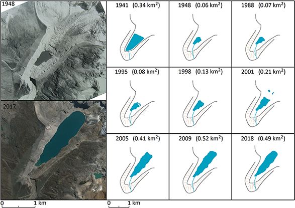
C. Huggel et al.: Anthropogenic climate change and glacier lake outburst flood risk                                           2179

Figure 2. Evolution of lake Palcacocha from 1941 to present (source of 1948 image: Archives of the Autoridad Nacional de Agua, Peru;
source of 2017 image: CNES/Airbus image, © Google Earth, date of acquisition: 18 June 2017; source of lake evolution data from 1988–
2018: Landsat images).

                                                                    ment studies (e.g., Hegglin and Huggel, 2008; Vilimek et al.,
                                                                    2005). The lake volume at that time was determined as being
                                                                    3.690 × 10⁶ m3 (+640 % in 29 years; Zapata et al., 2004), al-
                                                                    though some doubts have arisen concerning the accuracy of
                                                                    this 2003 lake bathymetry, and the lake area in fact would
                                                                    suggest a higher lake volume. The existing hazard mitiga-
                                                                    tion measures built in the 1970s were no longer found to be
                                                                    sufficient (Emmer et al., 2018). In 2009, a new bathymetry
                                                                    revealed that the lake had grown to 17.325 × 10⁶ m3 (Porto-
                                                                    carrero, 2014). As a response, six siphons were installed in
                                                                    2011 to temporarily reduce lake volume prior to the imple-
                                                                    mentation of a permanent engineering solution. This project
                                                                    progressed slowly in the context of institutional instability,
                                                                    and volume regulation remains ongoing in 2019 with a set of
                                                                    10 siphons.
                                                                       With a volume of 17.403 × 10⁶ m3 in 2016 (i.e., +3380 %
                                                                    in 42 years; UGRH, 2016), lake Palcacocha is among the
                                                                    largest moraine-dammed lakes in the Cordillera Blanca. Fur-
                                                                    ther potential for lake growth is, nevertheless, limited by to-
Figure 3. Evolution of area and volume of lake Palcacocha from      pographic constraints of lateral side moraines and bedrock
1941 to present (data sources: see Table 1).                        slope reached in the rear part of the lake. According to the
                                                                    recent lake inventory and GLOF susceptibility assessment
                                                                    (Emmer et al., 2016), Palcacocha is among the lakes suscep-
with an inaccurate but high-publicity NASA announcement             tible to the production of a GLOF, which could be triggered
1 month later in April 2003 about glacier instability above         by rapid landslide processes from surrounding moraines, ice
Palcacocha, reopened discussions about the lake’s threat to         and rock slopes. A detailed study of a potential landslide-
the city of Huaraz (Carey, 2010; Kargel et al., 2011). Given        induced outburst flood was performed by Klimeš et al. (2016)
the more than 110 000 inhabitants of Huaraz at the time,            and flood and inundation hazard modeling for Huaraz was
these events led to a number of new hazard and risk assess-         published by Somos-Valenzuela et al. (2016) and Frey et al.

https://doi.org/10.5194/nhess-20-2175-2020                                 Nat. Hazards Earth Syst. Sci., 20, 2175–2193, 2020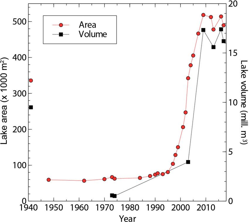
2180                                   C. Huggel et al.: Anthropogenic climate change and glacier lake outburst flood risk

(2018), suggesting a decreasing hazard level if the water level    the most likely cause of the longer-term warming (Vuille et
is lowered. The population of Huaraz has increased from ap-        al., 2015).
proximately 12 000 residents at the time of the 1941 GLOF             We proceed along the impact cascade (Fig. 4) with
to about 140 000 today, with tens of thousands inhabiting the      glaciers. Glaciers are closely coupled to the climate system,
path that the 1941 followed along the Quillcay River.              but surprisingly only very few studies that explicitly attribute
                                                                   glacier change to anthropogenic climate change exist world-
                                                                   wide. If we revisit glacier decay in the Cordillera Blanca, in-
3   Physical drivers of risk                                       cluding the Palcacocha area, we find a phase of rather strong
                                                                   glacier retreat in the late 19th century, followed by a slow-
In this section we explore to what extent flood hazard and         down in the early 20th century with small advances in the
risk from lake Palcacocha can be attributed to anthropogenic       1920s (Kinzl, 1969). Later, a period of strong glacier shrink-
climate change and to other physical drivers of risk. This         age in the 1930s and 1940s led to a phase of slow retreat
is a challenging task with hardly any precedents and first         in the 1950s to 1970s, eventually followed by very marked
needs some conceptual considerations, drawing on recent un-        glacier loss since the late 1970s up to the present (Georges,
derstandings of how impacts can be attributed to (anthro-          2004; Hastenrath and Ames, 1995; Kaser and Georges, 1997;
pogenic) climate change (Cramer et al., 2014; Stone et al.,        Rabatel et al., 2013). The continuous mass loss since the late
2013). A formal attribution study investigates whether a par-      1970s was enhanced (or reduced) by variations in the Pa-
ticular system has shown any observable trend and whether          cific sea surface temperatures and El Niño–La Niña phases,
this trend can be attributed to anthropogenic climate change.      respectively, with ENSO exerting a significant effect on
Figure 4 visualizes a cascade of impacts from anthropogenic        Andean glaciers on interannual timescales. The long-term
emissions to climate change, glacier shrinkage, and lake           glacier-shrinking trend, however, cannot be explained by
growth and eventually to GLOFs and the resulting flood haz-        ENSO-related variability (Schauwecker et al., 2014; Vuille
ard and damage. If we want to decipher the influence of cli-       et al., 2015), and therefore climate change clearly plays a
mate change on GLOF hazard we need to analyze each com-            significant role. This is also reinforced by the IPCC, who at-
ponent of this cascade of impacts, considering that a varying      tributed glacier retreat in the Andes to climate change with
number of confounding factors (i.e., factors not related to cli-   very high confidence (Magrin et al., 2014).
mate change) interact at each stage.                                  A global-scale study finds that more than two-thirds of the
   In this cascade, we start with climate change where attribu-    1991–2010 global glacier mass loss is due to anthropogenic
tion research has a long and advanced track record and would       forcing, while for tropical regions (including the Cordillera
typically conclude with a statement such as to what degree         Blanca) an anthropogenic signal in observed glacier mass
the observed climatic changes or trends can be attributed to       loss of recent decades is detectable with high confidence
anthropogenic emissions (Bindoff et al., 2013; Stott et al.,       (Marzeion et al., 2014). A new study, however, focusing
2000).                                                             specifically on Palcaraju glacier (the glacier driving the
   Specific studies on the attribution of observed climatic        growth of lake Palcacocha), concludes that close to 100 % of
trends in the tropical Andes to anthropogenic emissions so         the observed temperature trend of 1.3 ◦ C warming since 1880
far hardly exist. Global-scale attribution studies and assess-     can be attributed to anthropogenic climate change and that
ments, however, have considered the broader Andes and Pa-          the glacier’s retreat is entirely attributable to the observed
cific coastal region. Bindoff et al. (2013) and Jones et al.       temperature trend (Stuart-Smith et al., 2020).
(2013) show that temperature changes in this region are               We now analyze how Palcacocha lake growth relates to
broadly in line with climate model runs that include anthro-       glacier shrinkage and anthropogenic climate change. Lake
pogenic forcing and clearly deviate from model runs with           Palcacocha extends on a relatively flat area that was previ-
natural forcing only. Further research has analyzed the ob-        ously occupied by glacier ice and is dammed by LIA and
servational temperature and precipitation record of the region     early 20th century moraines. Lake growth at Palcacocha can
over the past few decades, as well as the link to phenomena        therefore be attributed to glacier retreat in a straightforward
of climatic variability such as the El Niño–Southern Oscil-        way, as glacier ice was simply replaced by lake water and
lation (ENSO) (Heidinger et al., 2018; Vuille et al., 2008).       close to 100 % of the lake growth can be explained by glacier
Schauwecker et al. (2014) and Vuille et al. (2015) concur that     retreat (Fig. 2). Thermal energy of lake water accelerates ice
temperatures in the Andes of Peru, including the Cordillera        mass loss at the glacier front, generating a positive feedback
Blanca, have increased since the beginning of the observa-         between glacier retreat and lake growth (Kääb and Haeberli,
tional record in the 1960s at rates of about 0.2 to 0.3 ◦ C per    2001). Lake growth was strongest in the 1990s and 2000s
decade, with reduced warming rates during the last ca. 30          (Fig. 3), coinciding with the period of high anthropogenic
years (∼ 0.1 ◦ C per decade).                                      emissions. Considering our well-documented glacier retreat
   While ENSO and the Pacific Decadal Oscillation (PDO)            and lake growth and new evidence on attribution of Palcaraju
exert an important influence on an interannual or decadal          glacier’s retreat from (Stuart-Smith et al., 2020), we therefore
scale, anthropogenic radiative forcing has been identified as      conclude that the growth of lake Palcacocha over the past 3

Nat. Hazards Earth Syst. Sci., 20, 2175–2193, 2020                                https://doi.org/10.5194/nhess-20-2175-2020
C. Huggel et al.: Anthropogenic climate change and glacier lake outburst flood risk 2181
Figure 4. Causation chain from anthropogenic emissions to glacier lake flood risk. At each element of the causation chain non-climatic
(confounding) factors are indicated, which also influence the respective element.
decades cannot be explained by natural variability and has a of close to 20 000 (Somos-Valenzuela, 2014). Based on spa-
clear and high anthropogenic signal. tial census data from the National Statistical Institute of Peru
How GLOF hazard and risk in Huaraz or elsewhere can be (INEI), here we found that about 22 500 inhabitants living in
attributed to anthropogenic climate change is still an open the high-hazard zone are highly exposed to GLOF (Fig. 5).
field of scientific debate. Physically, flood risk in Huaraz However, because the high-hazard zone intersects with the
is determined by GLOF hazard, which is a function of the central business and market places of Huaraz, the number of
magnitude (or intensity, such as flood height) of a hazardous people present during the day is much higher, possibly up to
process at a given location and its probability of occurrence 50 000.
(Raetzo et al., 2002; UNISDR, 2009). A number of factors While recent studies quantitatively attributed the retreat of
influence and determine GLOF magnitude and probability Palcaraju glacier to anthropogenic climate change (Stuart-
of occurrence at lake Palcacocha, notably lake volume, dam Smith et al., 2020), it remains to be clarified whether quan-
stability, and freeboard, as well as landslides from unstable titative attribution can also be achieved for GLOF hazard
moraines or ice/rock avalanches impacting the lake (Emmer encountered at Huaraz or whether only qualitative state-
and Vilímek, 2013; Schneider et al., 2014). Some of the fac- ments are possible at the current state of science. Overall,
tors (such as lake formation) are closely related to climate despite the non-climatic factors also influencing GLOF haz-
change, while others are associated with geologic or geotech- ards, we can confidently state that the clear and strong signal
nical conditions (e.g., dam stability) or are explicitly influ- of anthropogenic emissions in the growth of lake Palcacocha
enced by human intervention aiming at reducing the risk of translates to GLOF hazard in Huaraz. In the absence of an-
GLOFs (e.g., lake freeboard determined by the height of the thropogenic climate change, the flood hazard would be much
constructed drainage canal). In addition to effects on glacier lower, primarily because the size of the lake would be sub-
retreat, climate change can influence some of these hazard- stantially smaller, and a longer, flat glacier tongue, as was
determining factors, e.g., increasing temperatures can de- present in 1941, would significantly attenuate the impact en-
grade permafrost and thus destabilize the flanks of the steep ergy of potential ice or rock and ice avalanches (Mergili et
headwalls surrounding lake Palcacocha or alter thermal con- al., 2020).
ditions and stability of steep glaciers (Carey et al., 2012; Fail-
lettaz et al., 2015; Haeberli et al., 2017).
To assess how GLOF hazard at lake Palcacocha trans- 4 Socioeconomic drivers of risks
lates into flood hazard in the city of Huaraz, we draw on
numerical mass flow simulations by Frey et al. (2018) and While physical drivers of GLOF hazard, such as climate
Somos-Valenzuela et al. (2016), who modeled different sce- change, ice loss and glacier lake expansion, increased risk
narios of avalanches impacting the lake and producing dam- in the valley below lake Palcacocha, many societal drivers
overtopping waves and downstream-propagating floods (see of risk have simultaneously intersected with geophysical
Supplement). They follow state-of-the-art hazard assessment changes and have exacerbated vulnerability and people’s ex-
approaches (GAPHAZ, 2017), which were also applied to posure in Huaraz. Socioeconomic status, governance and in-
others lakes in the Cordillera Blanca (Schneider et al., 2014). stitutional aspects, technology and knowledge production,
Corresponding model results indicate that an urban area of and cultural forces have all influenced GLOF risk from Pal-
similar size as that destroyed by the 1941 GLOF is threat- cacocha. For one, risks stem from the placement of the city of
ened by high GLOF hazard and thus by potential devastating Huaraz and its ever-increasing population at the confluence
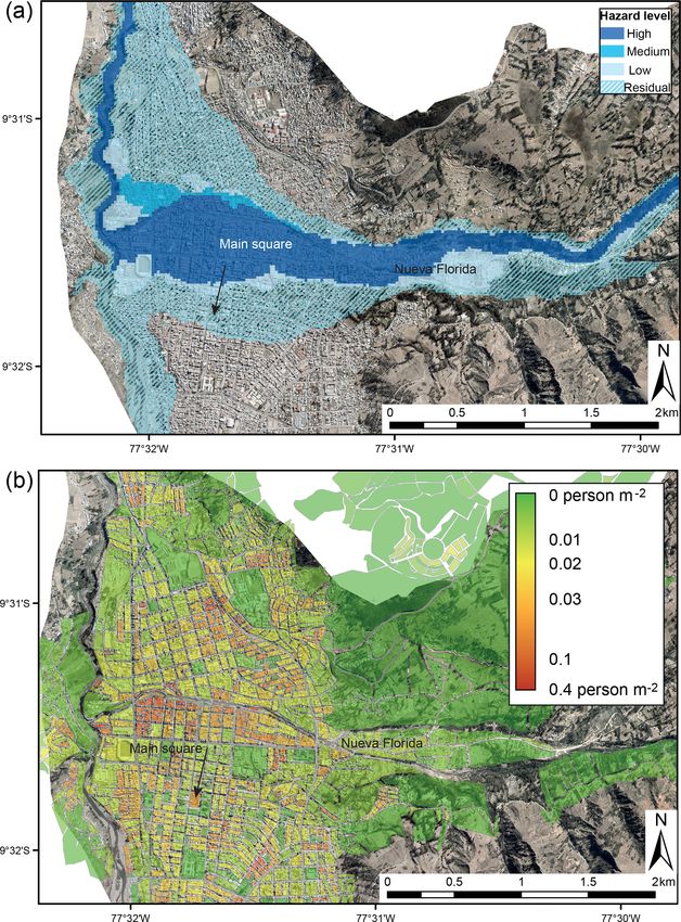
effects (Fig. 5). Previous studies estimated about 40 000 peo- of the lower Quillcay River and the Santa River, where sev-
ple living in the inundation zone with a potential death toll eral Cordillera Blanca lake basins drain. Spanish colonists
initially founded Huaraz in the 16th century, preferring to
https://doi.org/10.5194/nhess-20-2175-2020 Nat. Hazards Earth Syst. Sci., 20, 2175–2193, 20202182 C. Huggel et al.: Anthropogenic climate change and glacier lake outburst flood risk
Huaraz and expanding upstream along the banks of the Quill-
cay River toward Palcacocha and other glacier lakes. Ac-
cording to flood hazard assessment and mapping presented in
Fig. 5, the Huaraz inhabitants most exposed to a future Palca-
cocha GLOF are clustered along the Quillcay river in the dis-
tricts of Nueva Florida, Antonio Raimondi, Centenario, parts
of San Francisco, Huarupampa, Nicrupampa, José Olaya
and Patay, which have largely expanded in the past decades
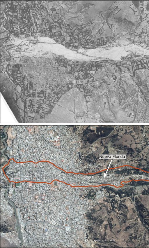
(Bode, 1990; Carey, 2010; Wegner, 2014). Figure 6 spatially
compares the urban area of Huaraz from the immediate af-
termath of the 1941 GLOF to the current situation, revealing
enormous urban growth including the most hazard-exposed
areas. Census data from a similar timeframe also show an
enormous population increase from about 11 000 in 1940 to
more than 140 000 in 2017 (Fig. 7). Several reasons moti-
vated inhabitants to resettle and build within the potential
path of a Palcacocha GLOF, even though they recognized
the GLOF risks. Analysis of these reasons helps illuminate
socioeconomic drivers of GLOF risk that are useful not only
for understanding Palcacocha but also for evaluating GLOF
and worldwide hazard risk.
First, inhabitants recognized key economic factors: some
believed they would incur direct economic losses if they
moved away, while others thought that inhabiting the area
along the Quillcay River adjacent to Huaraz would yield eco-
nomic gains. This dynamic emerged as early as the 1940s,
and residents were outspoken about defending their rights to
live in the potential GLOF path – often based on economic
Figure 5. (a) Hazard map for the city of Huaraz as related to GLOFs reasoning – starting in the 1950s (e.g., Anonymous, 1956,
from lake Palcacocha. The district of Nueva Florida and the main 1951, 1945). Inhabitation of flood-prone areas and other
square of the city are indicated (for a more detailed description places susceptible to natural disasters, even when people un-
of the hazard mapping methodology, see the Supplement) (image derstand the risks, is not unusual (e.g., Steinberg, 2000; Wis-
source: © Google Earth/Maxar Technologies; date of acquisition: ner et al., 2004). In Huaraz, however, many worried that the
10 Oct 2017). (b) Population distribution for the same extent of government would not compensate them for their lost land
Huaraz. Also indicated is the extent of the high-hazard zone (dark or provide them with a comparable plot and home elsewhere.
blue in a) (source of population data: INEI). Others were concerned that relocation of the city or even
moving upslope to safer terrain would diminish Huaraz’s po-
sition as the region’s financial hub, where jobs and markets
build their towns on valley floors in riparian zones, a pattern offered opportunities, transportation and commercial centers
that contrasted with pre-Columbian populations that imple- attracted people, and banks and credit institutions existed
mented a form of hazard adaptation by settling in upland ar- (Doughty, 1999; Oliver-Smith, 1977, 1999). While many
eas away from alluvial fans (Oliver-Smith, 1999). The 1941 were reluctant to leave Huaraz for these economic reasons,
Palcacocha GLOF illustrated the consequences of this place- others migrated into the city for related motives, such as re-
ment and the city’s long-term exposure to Cordillera Blanca ceiving relief and disaster aid following the catastrophe (Wal-
hazards (Wegner, 2014). ton, 1974; Wrathall et al., 2014).
Following the flood, authorities attempted to reduce haz- One part of Huaraz, the Nueva Florida district adjacent
ard zone inhabitation by prohibiting construction in the to the Quillcay River, exemplifies these economic incentives
GLOF path, but residents and newcomers ignored the hazard outweighing GLOF risks. Ethnographic research we con-
zoning policies, and the government did not enforce its man- ducted in the area provided insights that exemplify the his-
date (Carey, 2010). After the devastating 1970 earthquake torical and contemporary factors playing into this dynamic.
destroyed much of Huaraz, the government again prohib- Quechua-speaking farmers from the highlands above Huaraz
ited reconstruction in the 1941 GLOF path due to new con- began buying inexpensive property in Nueva Florida after
cerns about unstable glacier lakes above Huaraz (Bode, 1990; the 1970s. This previously vacant land was not only afford-
Carey, 2010; Oliver-Smith, 1986). Once again, residents de- able but also offered proximity to employment, public ser-
fied government hazard zoning, both rebuilding downtown vices and an overall higher standard of living for historically
Nat. Hazards Earth Syst. Sci., 20, 2175–2193, 2020 https://doi.org/10.5194/nhess-20-2175-2020C. Huggel et al.: Anthropogenic climate change and glacier lake outburst flood risk 2183
unique opportunity for Quechua-speaking villagers to access
social and economic opportunities in Huaraz. According to
a survey we conducted in 2017 (see the Supplement), most
Nueva Florida residents showed little concern for the risk of
flooding either in the past or today. Though many were aware
of recent public and media discussions about the threat of a
Palcacocha GLOF, they contended that such warnings were
exaggerated. It appears that economic and material benefits
of inhabiting Nueva Florida outweigh the potential flood risk.
Second, social status among Huaraz residents – influ-
enced primarily by racial and class divisions – has been
another key factor influencing GLOF risk and explaining
some inhabitants’ continued occupation of the Quillcay ri-
parian zone. Cities like Huaraz have long been inhabited by
the ruling classes – the Spanish-speaking residents and sup-
posedly non-indigenous people (Oliver-Smith, 1999). Liv-
ing higher and more rurally, on the other hand, signified
a poorer, more indigenous status in this culturally con-
structed schematic of race–class dynamics (Walton, 1974).
Post-disaster urban zoning after the 1941 GLOF and 1970
earthquake that attempted to relocate populations to safer
ground higher above the river came to symbolize, for some, a
government-imposed assault on ruling-class privilege, down-
ward social mobility and loss of socioeconomic status (Bode,
1977, 1990; Carey, 2010; Doughty, 1999).
Analysis of GLOF risks, exposure and vulnerability must
consider both how inhabitants rank their risks and how disas-
ter prevention policies such as hazard zoning, building prac-
tices and urban planning affect socioeconomic status. It is
difficult to pinpoint responsibility for people’s decisions to
inhabit the potential GLOF path below Palcacocha. Inequal-
ity driven by class and race divisions has led to the marginal-
ization of some segments of the Peruvian population. As a
result, their decision-making may be shaped by economics,
livelihood and employment opportunities, social standing,
Figure 6. Aerial photograph from 1948 showing the traces of the
1941 GLOF (upper panel) and a 2016 satellite image of the same and other socioeconomic factors that are usually impossible
area (lower panel). The outlines in orange indicate the extent of to assign to certain individuals but instead can be assigned
the area affected by the 1941 GLOF. The highly flood exposed ur- to overall populations, such as racism, poverty and global
ban district of Nueva Florida is indicated (source of upper image: inequality. Furthermore, the economic level of Peruvians, in-
Archive of Autoridad Nacional de Agua, Peru, year of acquisition: cluding the citizens of Huaraz, is also affected by global his-
1948; lower image: © Google Earth/Maxar Technologies, 11 Octo- tories and legacies of colonialism, neoliberalism, resource
ber 2017). extraction, political domination and economic marginaliza-
tion. Parts of these historical processes continue to affect the
lives of people in Huaraz, which contributes to making them,
marginalized people. In the 1990s, new multinational mining generally speaking, poorer compared to residents of the most
operations near Huaraz triggered an influx of mine workers, developed nations, who tend to have lower levels of vulnera-
who frequently settled in Nueva Florida. Given the district’s bility and can afford to rank risks differently than Peruvians
growth, authorities built paved roads and installed electricity living beneath lake Palcacocha (Carey, 2010).
and sewage networks in Nueva Florida in the early 2000s.
Today, Nueva Florida is a flourishing district, attracting even
more people to the area along the Quillcay River. While 5 Institutional and governance-related risk drivers
authorities have officially prohibited construction in Nueva
Florida since Palcacocha GLOF risk concerns arose again in Institutions, policies and governance also affect levels of
2009, residents attest that officials tolerate the construction GLOF risk. In particular, government instability, fluctuating
of smaller buildings. Over time, living in Huaraz provided a support (funding and resources), and institutional inconsis-
https://doi.org/10.5194/nhess-20-2175-2020 Nat. Hazards Earth Syst. Sci., 20, 2175–2193, 20202184 C. Huggel et al.: Anthropogenic climate change and glacier lake outburst flood risk Figure 7. Population growth of Huaraz over the period 1941–2017. Data since the year 2000 are based on an extrapolation produced by the National Statistical Office of Peru (INEI) (a). Vulnerability indicators and their changes between 2002 and 2012 for the city of Huaraz: human development index (HDI), the percentage of population with secondary education and family income per capita in Peruvian Nuevo Soles per month (data from INEI) (b). tency creating confusion about disaster-prevention roles and tion and nonaction that left residents more vulnerable or ex- responsibilities have all exacerbated risk below lake Palca- posed to potential GLOFs. cocha. It initially took 10 years after the 1941 Huaraz disaster Amidst decentralization, the Ancash government has also to form the first GLOF prevention office, the Control Com- experienced exceptional turmoil in recent years: since 2014, mission of Cordillera Blanca Lakes (CCLCB). Since the es- three governors of Ancash have been imprisoned over tablishment of the first glaciology and lake security office in charges including corruption and assassination (El Comer- 1951 to mitigate Cordillera Blanca GLOF risks, the agency cio, 2018). Further, there remains a host of national govern- has passed through four different ministries, had 12 different mental institutions and ministries with jurisdiction over the names and even disappeared completely for nearly 4 years Cordillera Blanca, including the Glacier and Lake Evaluation in the late 1990s (Carey, 2010). Some disaster events (e.g., Office (formerly the Glaciology and Water Resources Unit, the 1950 Los Cedros GLOF and the 1970 earthquake and UGRH) of the National Water Authority (ANA) and asso- Mount Huascarán avalanche) and some authoritarian govern- ciated local and provincial water authorities and Huascarán ments (e.g., Presidents Odría in the 1950s and Velasco in the National Park. They interact with the Ancash regional gov- 1970s) stimulated strong investments in Cordillera Blanca ernment; provincial and municipal authorities and their cor- GLOF prevention. At other times, glacier disasters (1962 responding entities, such as civil defense; rural community Ranrahirca avalanche) and authoritarian governments (Pres- jurisdictions (comunidades campesinas); and a host of other ident Fujimori in the 1990s) triggered little government re- stakeholders including mining companies, Duke Energy, and sponse or even backward steps in GLOF risk reduction. non-governmental organizations (NGOs). More specifically Decentralization of the national government has also ex- for GLOF risk reduction, the national government agencies, acerbated institutional inconsistency and instability, which ANA, and the National Institute for Glacier and Mountain also influences GLOF risk. Prior to the 2002 start of the de- Ecosystem Research (INAIGEM), founded in 2015, operate centralization process, Peru’s 25 departmental governments in the Cordillera Blanca but sometimes overlap in confusing functioned as administrative extensions of the national gov- ways, ultimately impeding institutional capacity to respond ernment, with departmental governors (prefects) appointed to increasing glacier risks. by the national government. During this period, the cen- This regional government instability and uneven decen- tral government directed and consolidated Cordillera Blanca tralization has obstructed effective GLOF risk reduction GLOF monitoring and mitigation. Decentralization created measures at lake Palcacocha specifically. In 2003, Palca- new, more autonomous regional governments that were in- cocha overflowed and caused a small flood due to a land- dependently elected (Arce, 2008; Dickovick, 2011). On pa- slide into the lake (Vilimek et al., 2005). While debate en- per, the reforms made the Ancash regional government pri- sued about jurisdiction and responsibility (e.g., Congreso marily responsible for identifying and implementing Palca- de la República, 2003), it took nearly a year to conduct cocha risk reduction measures, but in practice decentraliza- a bathymetry study and repair the damaged flood protec- tion generated confusion about jurisdiction, expertise, au- tion dam at the lake. In 2009, when a new study revealed thority, funding and responsibility, often leading to stagna- that Palcacocha contained 17 million cubic meters of water Nat. Hazards Earth Syst. Sci., 20, 2175–2193, 2020 https://doi.org/10.5194/nhess-20-2175-2020
C. Huggel et al.: Anthropogenic climate change and glacier lake outburst flood risk                                          2185

(more than it had for the 1941 GLOF), no single institution       ments to land and community also motivated people to re-
took charge and led a permanent engineering project to par-       main living in Huaraz, even after disasters struck or when
tially drain and secure the lake, as the UGRH had done for        they had knowledge of GLOF risks (Bode, 1990; Oliver-
decades previously. Instead, the institutional instability gen-   Smith, 1982, 1986; Yauri Montero, 1972). While some sur-
erated only short-term, unsustainable measures (temporary         vivors emigrated to Lima after the 1941 and 1970 disasters,
siphons) to protect downstream populations, despite repeated      others remained in their former homeland, connected to their
studies documenting risks relating to Palcacocha (Hegglin         birthplace, close to those who died in the disasters, and part
and Huggel, 2008; Klimeš et al., 2016; Portocarrero, 2014;        of the same community where they had always lived and ex-
Somos-Valenzuela et al., 2016; Vilimek et al., 2005).             perienced trauma.
   In response to political inaction at a regional level, the        Another factor influencing risk is the diverse understand-
local governments of Huaraz and Independencia – the two           ings of environmental processes and hazards, particularly
main municipalities affected by GLOF risk from Palcacocha         where scientific and technical explanations contrast with lo-
– have collaborated to implement a Palcacocha early warn-         cal beliefs and values. In May 2017, two ice avalanches
ing system. Moreover, in 2016, international experts, in co-      descended into lake Palcacocha within a 24 h period, caus-
operation with local institutions, released a new hazard map,     ing 3 m high waves that lake workers witnessed. The work-
including GLOF hazards and evacuation plans, for the Quill-       ers’ supervisor maintained that this event occurred because
cay catchment (Frey et al., 2018; see Sect. 3 above). In-         he had not paid tribute to Palcacocha and the surrounding
ternational scientific institutions and NGOs primarily took       mountains. For workers at Palcacocha and other Quechua-
charge of producing the map, in collaboration with (but with-     speaking farmers living nearby, the lake and mountains are
out leadership of) local, regional or national institutions in    beings that require respectful engagement. According to this
Peru. Overall, a combination of effects has contributed to the    understanding of glaciers and lakes, spiritual disruptions
increase in risk, namely related to decentralization of the na-   could trigger a GLOF – such as lake workers’ inadequate
tional government; institutional instability; conflicting roles   offerings to mountain beings, rather than only geophysical
and jurisdictions; and waning government support for Pal-         processes such as glacier and bedrock instability. Some lo-
cacocha hazard reduction research, monitoring, and projects.      cal accounts voiced that past glacier-related disasters such as
Given the complexities surrounding these processes and dy-        the 1941 GLOF occurred because people failed to show the
namics over time, a more detailed indication of their contri-     landscape entities adequate respect (Yauri Montero, 2000).
bution to risk is elusive.                                        According to our interviews and focus groups that we con-
                                                                  ducted in 2017 and 2018, some elderly villagers in areas be-
                                                                  low Palcacocha corroborate these stories. In one of these lo-
6   Cultural and emotional components of risk                     cal’s accounts of the 1941 flood, 2 a deity told a rural woman
                                                                  to perform a ritual offering at Palcacocha. When she failed
Cultural factors also influence risk in the valleys below lake    to do so, the lake became angry and flooded Huaraz. When
Palcacocha. Attachment to place can motivate people to in-        asked why Cordillera Blanca glaciers are melting, lake work-
habit potential flood zones, while varying local explanations     ers at Palcacocha pointed to contamination and global in-
of cause and effect (particularly causation between human         dustry. While they recognized a global dimension of envi-
behavior and environmental change) can also yield certain         ronmental change, they regularly paid tribute to the lake and
understandings of risk that collide with scientific assessments   mountains in an effort to prevent disaster. As long as the su-
and may lead to inaction in the face of GLOF risks. Re-           pervisor kept the lake happy with offerings of coca leaves
search on these cultural dimensions of glaciers is growing        and alcohol, he explained, there would be no GLOF disaster.
both elsewhere (Allison, 2015; Cruikshank, 2005; Sherpa,             These accounts thus reveal how local people perceive both
2014; Sherry et al., 2018) and in the Peruvian Andes and          global and local aspects as drivers of risk, but their percep-
Cordillera Blanca specifically, where locals often perceive       tions are often not in line with technical and scientific assess-
sentient landscapes and maintain spiritual relationships with     ments of risk. For instance, many urban and rural residents
mountains and glaciers (Bolin, 2009; Carey, 2010; De la Ca-       have referred to enchanted lakes, which, in local understand-
dena, 2015; Jurt et al., 2015). One key cultural driver of risk   ings, can lure people to their shores and then suck people in-
along the Quillcay River is the emotional and psychologi-         side, to the other world, if they do not perform proper rituals
cal attachment to place that has historically attracted people    or resist approaching these lakes (Carey, 2010; Yauri Mon-
to Huaraz, even after the 1941 GLOF and 1970 earthquake           tero, 2000). Other residents offer different cultural explana-
devastated the city. A profound sense of place – that is, at-     tions for natural disasters, such as Catholic residents say-
tachment to homelands, personal identity, heritage, familiar-     ing that the 1970 earthquake resulted from sinners’ behavior
ity with landmarks and landscapes, and links to community –       and God’s will (Bode, 1990; Oliver-Smith, 1986). Attributing
frequently bonds people to particular places, not just in areas   GLOFs to their neighbors’ behaviors or to the will of certain
prone to GLOFs but in disaster zones worldwide (Hastrup,
2013; Oliver-Smith, 1982; Sherry et al., 2018). These attach-        2 Interview conducted in 2017.

https://doi.org/10.5194/nhess-20-2175-2020                               Nat. Hazards Earth Syst. Sci., 20, 2175–2193, 2020
2186 C. Huggel et al.: Anthropogenic climate change and glacier lake outburst flood risk
deities can ultimately lead to a relinquishment of responsi- the case of Palcacocha, a complex network of responsibili-
bility and fatalism: why move outside a potential GLOF path ties and dependencies exists between different agents of re-
if floods are determined by God’s will or neighbors’ sins? sponsibility and institutions. Differentiation and assignment
When a resident believes sinning causes floods or coca leaf of responsibilities to subjects depends on the perspective of
offerings presented to mountain deities stabilize glacier lakes the different drivers of GLOF risk and on whether a forward-
– as opposed to the scientific conclusions attributing these or backward-looking concept of responsibility is adopted
processes to climate change, glacier shrinkage or bedrock (Miller, 2007). Backward-looking assignment of responsibil-
geometry – then development and implementation of risk re- ities identifies the agents bearing responsibility for risks and
duction plans become more difficult, as not everyone agrees outcomes already materializing and can be adopted to justify
about the source of the hazard. In fact, people in Huaraz ne- corrective duties. Forward-looking ascription of responsibil-
gotiate cultural and scientific understandings of flood risk on ities concerns remedial duties to prevent negative impacts
a daily basis and may regard multiple explanations as valid. or minimizing risks (Burns and Osofsky, 2009; Grossman,
These trends in the Cordillera Blanca also exist inter- 2003).
nationally, and people knowingly inhabit areas exposed to Observed physical risk drivers indicate that, to a large ex-
GLOFs in other glacier-fed watersheds. In some cases, they tent, glacier shrinkage and lake growth are due to anthro-
are “forced” into these areas due to cheaper land in the flood- pogenic climate change, which also contributes to GLOF
plain or nearby job and livelihood opportunities (Carey et al., risks. Detection and attribution research is primarily a
2014; Orlove et al., 2019). In other cases, they select GLOF- backward-looking science and may inform the assignment
prone sites to live due to historical and cultural connections of responsibilities for past emissions causing present climate
to those flood-prone places (Sherry et al., 2018), they uti- risks (Huggel et al., 2016; James et al., 2019). Historically,
lize other cultural or spiritual techniques to manage glacier- emitters contributing to climate change are primarily highly
related risks (Allison, 2015; Gagné, 2019), or they possess developed western countries and regions, with large emerg-
different local knowledge about risk that sometimes differs ing economies strongly increasing their emission footprint
from scientific or institutional assessments of GLOF risks over the past couple of decades. Accordingly, detected and
(Drew, 2012; Williams and Golovnev, 2015). Furthermore, in attributed physical risk drivers of GLOFs allow us to ascribe
India, for example, there are documented recent major GLOF some responsibilities for increased risk of GLOFs to these
disasters that are also due to exposure and high vulnerability countries and regions. In climate litigation, countries or pri-
of a large number of people due to religious and tourism- vate companies, typically large corporations as in the case of
related reasons (Allen et al., 2016). Lliuya vs. RWE, are sued by plaintiffs, and courts verify the
legal responsibilities (liabilities) of these entities.
Attribution research has only limited explanatory value for
7 Implications for responsibility and justice assigning forward-looking responsibilities, which also de-
pends on the extent to which specific future risks are con-
So far we have examined physical climate-change-related, trolled by past emissions and related environmental changes.
socioeconomic, institutional and cultural aspects of Palca- For instance, lake Palcacocha has formed as a result of cli-
cocha GLOF risk. Drawing on that, we now analyze the pos- mate and glacier change of the past decades but is likely to
sible implications for responsibility and ask how concepts of persist for decades or even centuries into the future. Assign-
justice can inform these and other similar issues. Responsi- ment of forward-looking responsibilities in case of climate-
bility as a concept commonly concerns four aspects that be- related loss and damage commonly implies remedying neg-
come relevant when analyzing the differentiation and assign- ative impacts or minimizing the risk of their occurrence, i.e.,
ment of responsibilities in specific circumstances and at dif- in case of Huaraz minimizing risks of GLOFs and their im-
ferent policy levels (Bayertz, 1995): (i) someone (the agent pacts (Wallimann-Helmer et al., 2019). Investigating the dif-
or subject of responsibility) is responsible for (ii) something ferent risk drivers can be useful to identify what risk reduc-
(the object of responsibility) and answerable to some (iii) in- tion measures need to be taken, but it cannot identify the ap-
stitution according to some (iv) norm. This conceptualiza- propriate responsibility bearers or whether remedial respon-
tion of responsibility encompasses aspects of legal liability or sibilities should concern monetary payments, help in build-
causal responsibility, explaining the link between the subject ing the required infrastructure and protection measures, as-
of responsibility and the object of responsibility that becomes sistance in governance, or capacity building (O’Neill, 2017;
relevant in legal cases like the court case Lliuya vs. RWE. Page and Heyward, 2016).
However, this understanding of responsibility is more gen- It seems plausible that the industrialized countries and
eral, including aspects and concerns that are beyond a more regions contributing most to anthropogenic climate change
narrow legal understanding of responsibility in the sense of could foster the development of appropriate infrastructure
liability. and capacity in order for the affected people to be able to gov-
Responsibility in this wider understanding often concerns ern local climate risk themselves (Wallimann-Helmer, 2016).
different agents and objects (Wallimann-Helmer, 2016). In In cases like Huaraz, this is particularly important for two
Nat. Hazards Earth Syst. Sci., 20, 2175–2193, 2020 https://doi.org/10.5194/nhess-20-2175-2020You can also read