ASSESSMENT OF HAZARD MAPPING SYSTEM IN GEORGIA AND RECOMMENDED ACTIONS - Road Map
←
→
Page content transcription
If your browser does not render page correctly, please read the page content below
ASSESSMENT OF HAZARD MAPPING SYSTEM
IN GEORGIA AND RECOMMENDED ACTIONS
Road Map

            2018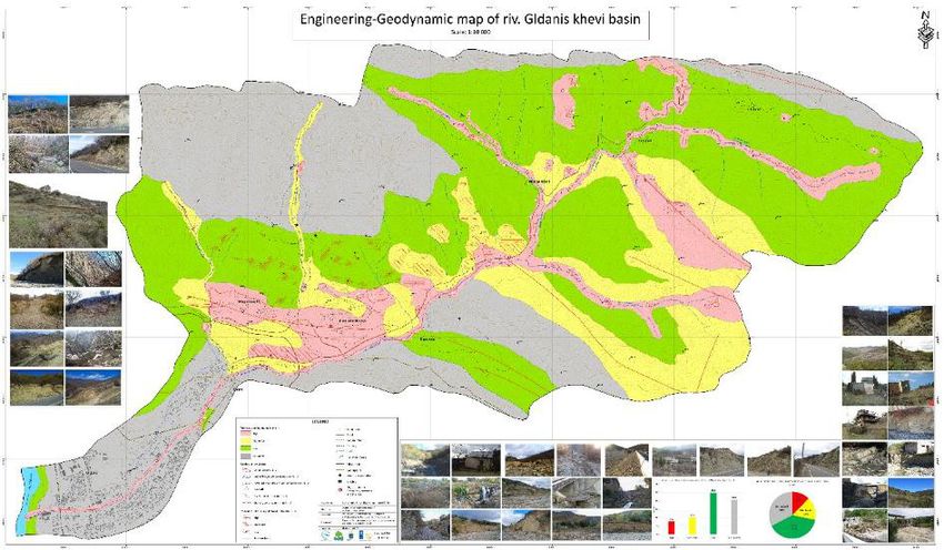
This publication has been prepared and published by the Georgia’s
Environmental Outlook (GEO) with the support from the United Nations
Development Programme (UNDP) and Swiss Agency for Development and
Cooperation (SDC). Its contents are the sole responsibility of its authors and
do not necessarily reflect the views of UNDP and SDC.
Contents
Acronyms and Abbreviations....................................................................................................... 3
Executive Summary...................................................................................................................... 7
Objective, scope and methodology of the study....................................................................... 7
Existing legal-regulatory and legal frameworks and key stakeholders..................................... 8
Capacity gaps......................................................................................................................... 11
Recommended actions........................................................................................................... 13
1.0 Objective, scope and methodology of the study................................................................ 16
2.0 Legal-regulatory and policy framework for hazard mapping............................................ 17
2.1 International commitments................................................................................................ 17
2.2 National legislation............................................................................................................ 19
2.3 Policy framework............................................................................................................... 21
3.0 Institutional setting for hazard mapping............................................................................. 23
3.1 State institutions................................................................................................................ 23
3.1.1 National Environmental Agency.............................................................................. 23
3.1.2 Emergency Management Service........................................................................... 32
3.1.3 Ministry of Regional Development and Infrastructure (MRDI)................................. 32
3.1.4 Ministry of Economy and Sustainable Development............................................... 32
3.1.5 Ministry of Defense.................................................................................................. 33
3.1.6 Georgian Air Navigation (Sakaeronavigatsia) ........................................................ 33
3.1.7 The Architecture Service of Tbilisi City Hall............................................................. 33
3.1.8 Ministry of Justice.................................................................................................... 34
3.1.9 NGOs and Private Sector ....................................................................................... 34
3.1.10 Academic and research institutions....................................................................... 36
3.1.11 Donors................................................................................................................... 36
4.0 Existing experience, practice, methodologies and available data/maps in the field
of hazard mapping....................................................................................................................... 37
4.1 Existing climate-induced hazard data and maps.............................................................. 36
4.2 Applied methodologies...................................................................................................... 37
4.3 Existing experience gained from various projects............................................................. 42
5.0 Gap and needs analysis of existing hazard mapping norms, practices and
capacities in relation to international commitments and national statutory and
policy requirements.................................................................................................................... 48
5.1 Gaps in climate-induced hazard mapping methodologies................................................ 48
5.2 Gaps in managing hazard databases............................................................................... 49
1
5.3 Gaps and needs in climate-induced hazard assessment and mapping............................ 49
5.3.1 Capacity gaps.......................................................................................................... 49
5.3.2 Capacity development needs.................................................................................. 52
5.3.3 Multi-hazard mapping.............................................................................................. 53
5.3.4 Knowledge gaps and needs of local academic and research institutions,
NGOs and private consultancies in hazard mapping, including multi-hazard mapping... 54
6.0 Conclusions and Recommended Actions.......................................................................... 54
6.1 Conclusions ..................................................................................................................... 54
6.2 Recommended actions (road map) to address capacity gaps in climate-induced hazard
mapping.................................................................................................................................. 56
2
Acronyms and Abbreviations
AAR Adjara Autonomous Republic
ADB Asian Development Bank
AF Adaptation Fund
AHS Automated Hydrological Station
ALCP Alliances Lesser Caucasus Programme
ARCC Agricultural Research and Consultation Centre
ASB Arbeiter-Samariter-Bund
ASL Above Sea Level
ASS Georgian Samaritan Association
AWS Automated Weather Station
BDD Basic Data and Directions
BMU German Federal Ministry for the Environment, Nature Conservation and Nuclear Safety
BS Bachelor of Science
BSME-FFG Black Sea and Middle East Flash Flood Guidance (BSMEFFG) System
BUR Biennial Update Report
0
C Celsius degree
CADRI Capacity for Disaster Reduction Initiative
CBMHEWS Community-based multi-hazard early warning system
CBMHRM Community-based multi-hazard risk management
CC Climate Change
CCA Climate Change Adaptation
CCD Climate Change Division
CCM Climate Change Mitigation
CCNH Centre for Control of Natural Hazards
CCTV Closed-circuit television (also known as video surveillance)
CENN Caucasus Environmental NGO Network
CEF Climate Forum East
CIS Commonwealth of Independent States
CLIDATA archiving software for climatological data
CMF Caucasus Mountain Forum
CMS Composite of Multiple Signals
CNF Caucasus Nature Fund
COP Conference of Parties
CORS Continuously Operating Reference Station
CRM Climate Risk Management
CSA Climate Smart Agriculture
CSO Civil Society Organization
CZDA Czech Development Agency
DELFT-FEWS open data handling platform/software developed by Deltares as a hydrological forecasting
and warning system
DEM Digital Elevation Model
DIPECHO EU Disaster Preparedness Programme
DMCT UN Disaster Management Coordination Team
DoECC Department of Environment and Climate Change
DRM Disaster Risk Management
DRR Disaster Risk Reduction
3
EC European Commission
ECCD Environment and Climate Change Division
ECMWF European Centre for Medium-Range Weather Forecasts
ED Environment and Development, Georgian NGO
EEC European Economic Community
EIA Environmental Impact Assessment
EIB European International Bank
EIEC Environmental Information and Education Centre
EMA Emergency Management Agency
EMS Emergency Management Service
ENPARD European neighbourhood programme for agriculture and rural development
ENPI European Neighbourhood and Partnership Instrument
EU European Union
EUAA EU Georgia Association Agreement (full title: ASSOCIATION AGREEMENT between the
European Union and the European Atomic Energy Community and their Member States, of
the one part, and Georgia, of the other part)
EUD EU Delegation to Georgia
EWS Early Warning System
FAO Food and Agriculture Organization
FD0 Number of frosty days (extreme weather index)
FCCC Framework Convention on Climate Change
FEWS Flood Early Warning System
FNC Fourth National Communication
FTP File Transfer Protocol
GCAA Georgian Civic Aviation Agency
GCF Green Climate Fund
GDP Gross Domestic Product
GEF Global Environment Facility
GEL Georgian Lari
GEO Georgia’s Environmental Outlook, Georgian NGO
GEO Group on Earth Observations
GEOSS GEO System of Systems
GEO CORS Georgian Continuously Operating Reference Station
G4G Governance for Growth (USAID Economic Development Programme)
GFA Gesellschaft für Agrarprojekte in Übersee (Society for agricultural projects, overseas)
GFS Global Forecast System
GIS Geographic Information System
GiZ Deutsche Gesellschaft für Internationale Zusammenarbeit (GIZ) GmbH
GNSS Global Navigation Satellite System
GoG Government of Georgia
GPRS General Packet Radio Service
GRF The Governance Reform Fund
GRCS Georgian Red Cross Society
GSHS Georgian State Hydrographic Service
GSM Global System for Mobile communications
GTU Georgian Technical University
HEC-HMS Hydrological modeling system of the Hydrological Engineering Centre
HCT Humanitarian Coordination Team
HR Human resources
4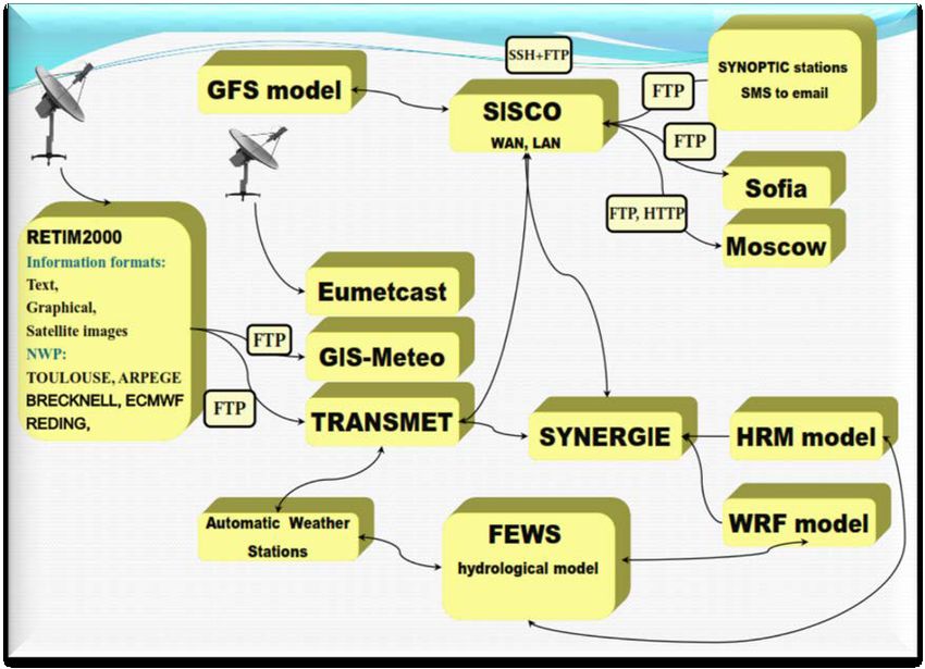
HRM Hydrological Research Model
HTTP Hypertext Transfer Protocol
IALA International Association of Marine Aids to Navigation and Lighthouse Authorities
ICRC International Committee of the Red Cross
ID0 Frosty days index
IDPs Internally Displaced Persons
IFAD International Fund for Agriculture Development
IHO International Hydrographic Services
INDC Intended Nationally Determined Contribution
INSPIRE Directive 2007/2/EC of the European Parliament and of the Council of 14 March 2007 es-
tablishing an Infrastructure for Spatial Information in the European Community
IP Internet Protocol
IR50 Tropical thunderstorm index (number of days with more than 50 mm precipitation)
JOC Joint Operational Centre
KfW Entwicklungsbank (German Development Bank)
km Kilometre
km2 Square kilometre
LAM Limited area model
LAN Local Area Network
LEPL Legal Entity of Public Law
LG local government
LMD Land Management Division
L-SLM Landscape and Sustainable Land Management
Ltd Limited liability
m metre
mm millimetre
m2 square metre
m3 cubic metre
MDF Municipal Development Fund
MoEPA Ministry of Environmental Protection and Agriculture
MoESCS Ministry of Education, Science, Culture and Sports
MoESD Ministry of Economy and Sustainable Development
MHEWS Multi-hazard early warning system
MIA Ministry of Internal Affairs
MIKE Flood computer program that simulates inundation for rivers, flood plains and urban drain-
age systems.
MRDI Ministry of Regional Development and Infrastructure
MS Master of Science
MWS Manual Weather Station
NALAG National Association of Local Authorities of Georgia
NAP National Adaptation Plan
NAPA National Adaptation Program of Action
NAPR National Agency for Public Registry
NC National Communication
NCMC National Crisis Management Centre
NDC Nationally Determined Contribution
NEAP National Environmental Action Programme
NEA National Environmental Agency
NEMIS National Emergency Management Information System
5
NFA National Food Agency
NGO Non-Governmental Organization
NVE Norwegian Water Resources and Energy Directorate
OCMC Operation Control/Management Centre
OPMET Operational aeronautical meteorological data
QA/QC Quality Assurance/Quality Control
PCPM Polish Centre for International Aid
PDNA Post-Disaster Need Assessment
PIF Project Identification Form
PPRD Prevention, Preparedness and Response to Natural and Man-made Disasters in the East-
ern Partnership Countries
RC/HC Resident Coordinator/Humanitarian Coordinator (of UNDP)
RDFG Association Rural Development for Future Georgia
RECC Regional Environmental Centre of Caucasus
RETIM 2000 part of World Meteorological Organization’s Global Telecommunication System
RS Remote Sensing
RTMC pro Real-Time Monitor and Control Software, Professional Version
SDC Swiss Development Cooperation Agency
SDG Sustainable Development Goal
SIDA Swedish International Development Agency
SISCO Security Identification Systems Corporation
SNC-mt Scientific Network for the Caucasus Mountain Region
SNC Second National Communication
SOLAS International Convention for the Safety of Life at Sea
SOP Standard Operating Procedure
SSCMC State Security and Crisis Management Council
SSH Secure Shell (cryptographic network protocol for operating network services securely over
an unsecured network)
SU25 Number of hot days index
TNC Third National Communication
TSU Tbilisi State University
TR20 Tropical nights index
TV Television
UN United Nations
UNECE The United Nations Economic Commission for Europe
UNEP United Nations Environment Programme
UNDP United Nations Development Programme
USA United States of America
USAID United States Agency for International Development
WAN Wide Area Network
WB World Bank
WG Working Group
WinZPV complex information system used by the Czech Hydrological Institute to record river water
measurements
WMO World Meteorological Organization
WMS Web Map Service
WRF model Weather Research and Forecasting Model
6
Executive Summary
Objective, The study “Assessment of hazard mapping system in Georgia and recom-
scope and mended actions (road map)” was developed under the inception phase of
methodology of the Project “Strengthening the Climate Adaptation Capacities in Georgia”,
the study implemented by the UNDP Country Office in Georgia with financial sup-
port from the Swiss Agency for Development and Cooperation (SDC). The
primary objective of the study is to assess the existing hazard mapping
architecture in Georgia, including current capacities and gaps, and based
on that, develop recommended actions (a “road map”) for the country to
fill the gaps and meet existing capacity needs in hazard mapping. It is
composed of the following parts:
A stakeholder analysis to identify relevant entities from national and
local governments, international and local non-governmental organi-
zations (NGOs), civil society organizations, and academia engaged
in hazard mapping;
An assessment of the institutional and legal set-up for hazard map-
ping in Georgia and progress achieved in implementation of interna-
tional commitments, existing practices, gaps and technical (including
financial) and human capacities for hazard mapping; and
A series of recommendations (road map) for the period (2018-2023),
with actions required to enhance hazard mapping capacities, as per
identified gaps/weaknesses.
The assessment only addresses mandates and capacities of stakeholders
engaged in mapping of climate-induced natural hazards such as: floods,
flash floods, mudflows, rockfalls, avalanches, strong winds, hailstorms,
droughts etc. The study covers the entire country as well as its regions,
except for the Adjara Autonomous Republic (AAR), which is covered by
another consultancy assignment commissioned by the UNDP Inception
Executive Summary
Phase of the project funded by SDC.
This report was developed by applying the following methodology:
Desk review and analysis of:
previously prepared studies/reports, in particular the feasibility
study of the UNDP/SDC/GCF project “Scaling-up Multi-Haz-
ard Early Warning System and the Use of Climate Information
in Georgia” (hereafter, the UNDP/SDC/GCF MHEWS project)
and the study “Consolidation of the hazard mapping methodol-
ogy and assessment of the legal framework for its application”,
carried out by the firm Geographic with SDC’s assistance under
7
the Civil Society Organizations (CSO) Disaster Risk Reduction (
(DRR) project in Georgia.
relevant current legal-regulatory and policy documents in the
area of hazard mapping
Interviews with public and non-public institutions engaged in hazard
mapping;
Capacity gap analysis against international commitments and nation-
al statutory requirements;
Stakeholder consultations.
Existing legal- International agreements. The major international agreements that set
regulatory and out Georgia’s obligations in hazard assessment and mapping are the fol-
legal frameworks lowing:
and key The Sendai Framework for Disaster Risk Reduction (2015-2030),
stakeholders the first priority of which is “Understanding disaster risk”, in-
cluding hazard assessment and mapping.
The Convention on Access to Information, Public Participation in
Decision-Making and Access to Justice in Environmental Matters
(Aarhus Convention), that obliges Georgia to provide a right for
all citizens to receive environmental information that is held by
public authorities (“access to environmental information”). This
includes information on the state of the environment.
The Association Agreement between the European Union and the
European Atomic Energy Community and their Member States
of the one part, and Georgia on the other part (EUAA) makes
reference to the Aarhus Convention and obliges Georgia to set
up a publicly available information management system. Further-
more, it requires the country to establish a flood assessment and
management system in line with the EU’s Flood Directive.
the European Directive 2007/2/EC establishing an Infrastructure
for Spatial Information in the European Community (INSPIRE)
aims to create an EU Spatial Data Infrastructure (SDI), enabling
the better sharing of environmental spatial information and public
access to spatial information across Europe. Geospatial infor-
mation considered under the Directive is extensive and includes
a great variety of themes, defined in its Annexes I, II III http://in-
spire.ec.europa.eu/data-specifications/2892. The INSPIRE geo-
portal prototype is available at http://inspire-geoportal.ec.europa.
eu. Regardless of the fact that Georgia is not obliged to trans-
pose INSPIRE into Georgia, the Government of Georgia (GoG)
has already started this process.
National statutory documents. The following national laws and regula-
tions are critical for hazard mapping:
Law of Georgia on Structure, Powers and Operational Procedures of
the GoG (2004), as amended in July 2018;
Law of Georgia on Basic Principles of Spatial Arrangement and City
Planning (2005), as amended in 2014;
8 Local Self-Governance Code (2014);
Law on Emergency Situations as amended in 2017;
Law of Georgia on Civil Safety of 3 May 2018; Civil Safety
Law of Georgia on the Procedure of Planning and Coordination of National Security (2015);
Resolution #262 of the GoG, dated 9 October 2013 on Setting up the Governmental Commis-
sion for the Creation and Development of Spatial Data Infrastructure;
Government resolution on a National Action Plan for the Implementation of the Association
Agenda between Georgia and the EU (approved annually by a governmental decree);
Resolution #508 of the GoG on Approval of Civil Security National Plan, of 24 September 2015;
Order #2-255 of the Minister of Environmental Protection and Agriculture (MoEPA) of Georgia on
Approval of the Regulations of the Legal Entity of Public Law - National Environmental Agency
(NEA), dated 19 April 2018; and
Government Resolution #4 on Approval of National DRR Strategy (2017-2020) and Action Plan.
Major policy documents. Major policy documents for hazard mapping are as follows:
Basic Data and Directions (BDD; 2018-2021), a mid-term expenditure framework for Georgia
including strategic directions and actions to be implemented by the GoG through state funding;
Intended Nationally Determined Contribution (INDC) defining Georgia’s plans until 2030 for cli-
mate change mitigation (CCM) and climate change adaptation (CCA), including hazard mapping;
National Environmental Action Plan (NEAP 3) , a major environmental policy document covering
the period 2017-2021 and containing long-term goals, immediate objectives and a number of
actions for CCA/DRR;
National Civil Safety Plan of Georgia (2015), a major policy document for the unified emergency
management system, regulating activities of the state, regional and local authorities in the area
of civil safety and, defining: i) protection measures for affected population and territories, their
scale, implementation procedures and competent main and supportive authorities, including risk
mapping; and ii) rules and procedures for prevention, preparedness, response, recovery and
rehabilitation works;
National DRR Strategy and Action Plan, containing national DRR goals, objectives, strategic
priorities and a plan of action for 2017-2020. The goal of the DRR Strategy is to create a unified,
flexible and efficient system, which will ensure reduction of natural and man-made disaster risks
by joint efforts and coordinated activities of the agencies defined in the Georgian legislation. The
National DRR Action Plan combines planned and ongoing projects, programmes and initiatives
of different Governmental agencies and NGOs. Concerning hazard assessment and mapping
and related activities, the action plan includes such actions as field studies for hydraulic and
hydrological modeling, development of hydraulic and hydrological models for high risk areas
of Tbilisi and other areas under high risk, monitoring of geodynamic processes, assessment
and mapping of geological hazards, assessment and mapping of avalanche hazards in several
highly susceptible areas, procurement of a regional radar for Kutaisi airport and mini-radars, and
integration of existing radar data into the NEA’s weather forecasting platform etc.;
Spatial arrangement and city development plans: currently with the assistance of GIZ, work is
ongoing to develop a National Spatial Arrangement Master Plan (NSAMP) and spatial and city
plans for various municipalities and settlements.
Institutional setting. Following are the key public institutions engaged in hazard assessment and
mapping:
National Agency for Public Registry (NAPR) under the Ministry of Justice (MoJ), responsible for
creating a unified geospatial information management system, through establishing a national
9geoportal and standards for geospatial information, as well as for a land cadastre;
National Environmental Agency (NEA) under the Ministry of Environmental Protection and Agri-
culture (MoEPA), responsible for monitoring and forecasting of hydrometeorological and geolog-
ical parameters and climate-induced hazards, assessing and mapping climate-induced hazards
and establishing and operating user-friendly climate, geological and climate-induced hazard da-
tabases;
Ministry of Regional Development and Infrastructure (MRDI) through its Spatial Planning and
Construction Policy Department1, responsible for development and coordination of implemen-
tation of a state policy on land use, land use zoning, urban development and spatial planning,
including facilitation/coordination of development of masterplans for land use, land use zoning
documents, urban development plans and spatial zoning documents, and development of tech-
nical methodologies for land use, spatial planning and urban development;
Emergency Management Service (EMS) under the Prime Minister’s Office, responsible for risk
assessment and mapping and running an emergency risk database to be interlinked with hazard
databases;
Ministry of Economy and Sustainable Development (MoESD) through the Georgian State Hy-
drography Service (GSHS), responsible for hydrographic surveys, cartography and weather
forecasting for the marine environment;
Georgian Air Navigation (Sakaeronavigatsia)2, a limited liability company fully owned by the
GoG, through its Meteorological service, responsible for the provision of necessary meteorolog-
ical information flights into and out of the city airports; and
Architecture Service of Tbilisi City Hall, responsible for a multi-layer interactive map of the city.
In the near future, it intends to integrate hazard and risk maps into its online map in cooperation
with the NEA and other stakeholders.
According to the newly-adopted Law on Civil Safety, as well as national Strategies on Civil Safety
and DRR, municipal authorities are responsible for developing emergency passports (assessment/
inventory of emergency threats/disaster risks) and local threat assessment documents, which also
implies hazard assessment and mapping.
Apart from public agencies, various NGOs are engaged in climate-induced hazard assessment,
modeling, mapping, processing geospatial information and developing various geospatial meta-da-
tabases. The most active NGOs are the following:
CENN, which in 2010-2014 was actively involved in hazard and risk mapping;
Sustainable Caucasus, involved in designing and introducing undergraduate and graduate uni-
versity courses for hazard mapping and DRR, based on a Swiss methodology;
Geographic, a GIS and Remote Sensing and Consulting Centre, active since 1998 in the areas
of GIS, spatial analysis and planning, development of thematic and web-based maps. It ap-
plies such methods as field topo-geodetic surveys, GIS, remote sensing (RS), photogrammetry,
GPS-technologies, integrated geodatabases, web-based maps and spatial planning etc.;
GeoLand, a GIS and spatial information management company, with some experience in hazard
mapping;
GisLab, a GIS and spatial information management NGO, with experience in sensitivity analysis
of Georgian forests, slope stability assessment and assessment of erosion processes; and
Environment and Development (ED), recently involved in: assessment of suitable flood miti-
gation measures in Tbilisi, with a major objective to improve the flood risk management in the
Tsavkisiskhevi River basin.
1 This function was recently transferred from the Ministry of Economy and Sustainable Development to the MRDI.
2 Source: http://airnav.ge/index.php?page=ms&fullstory=49
10Concerning academic and research institutions, there are geography and
geology departments under the applied science faculty at Tbilisi State
University (TSU) for undergraduate and graduate degree programmes.
Among various mandatory courses is one on assessment of natural haz-
ards. Furthermore, the Institute of Geophysics at TSU has experience
in multi-hazard assessment, including assessment of earthquakes, land-
slides, snow avalanches, flash floods, mudflows, droughts, hurricanes,
frost and hail.
Major donors active in Georgia in climate-induced multi-hazard mapping
are the following:
SDC, supporting capacity development for DRR and hazard mapping,
including development of capacities of academic institution in DRR
and hazard mapping;
UNDP, supporting establishment of a near-real-time multi-hazard ear-
ly warning system across the country through financial assistance
from the Green Climate Fund (GCF) and SDC;
the EU, supporting adoption of major provisions of its Flood Directive;
Sida, supporting establishment of information/data management sys-
tems in line with EU standards;
FAO, supporting development of agrometeorological monitoring and
advisory services; and
the German Federal Ministry for the Environment, Nature Conserva-
tion and Nuclear Safety (BMU), through GIZ, supporting development
of the National Spatial Arrangement Plan and Spatial Arrangement
and City Plans for selected municipalities.
Capacity gaps Based on the review and analysis of existing climate-induced hazard
mapping architecture, gaps and capacity needs, the following conclusions
can be drawn and relevant recommendations made:
Climate-induced hazard mapping methodologies. There is no sin-
gle regulation on a commonly-agreed, international, standards-based
methodology for multi-hazard assessment and mapping in Georgia.
Moreover, there is no EU-compliant flood assessment and mapping
methodology as mandated by the EUAA.
Hazard databases/maps and data accessibility:
There is a shortage of data and information on climate, geolog-
ical and geographic parameters necessary for climate-induced
natural hazards in Georgia.
The most comprehensive, renewable, open-source database on
natural hazards (the Web-Portal on Natural Hazards and Risks)
hosted by the CENN is outdated. Relevant stakeholders do not
actually use or maintain it. Moreover, maps contained in the Por-
tal are of very small-scale.
Currently, generally available climate-induced hazard maps with-
in the NEA are for floods and geological hazards (landslides,
mudflows, rockfalls etc.). For other climate-induced hazards, in-
cluding flash floods, droughts, strong winds and hailstorms, haz-
11 ard maps are lacking. Most maps are of small scale (1:100 000 and more) and there is a
significant shortage of small-scale maps, which require hydrometeorological and geological
parameters that the NEA also lacks.
A major portion of climate and geological data and information necessary for hazard map-
ping is archived at the NEA mostly in paper format, and these data are not available for free
to non-public sector representatives.
Existing hazard, climate and geological databases and GIS maps are not fully compatible
with the requirements and standards of the INSPIRE Directive and are not linked with the
Geospatial Portal, created within the NAPR under the Sida-supported project which aims at
building a unified geospatial information system in Georgia, having a single geoportal and
relevant meta-databases in line with the INSPIRE Directive.
Climate-induced hazard assessment and mapping practices
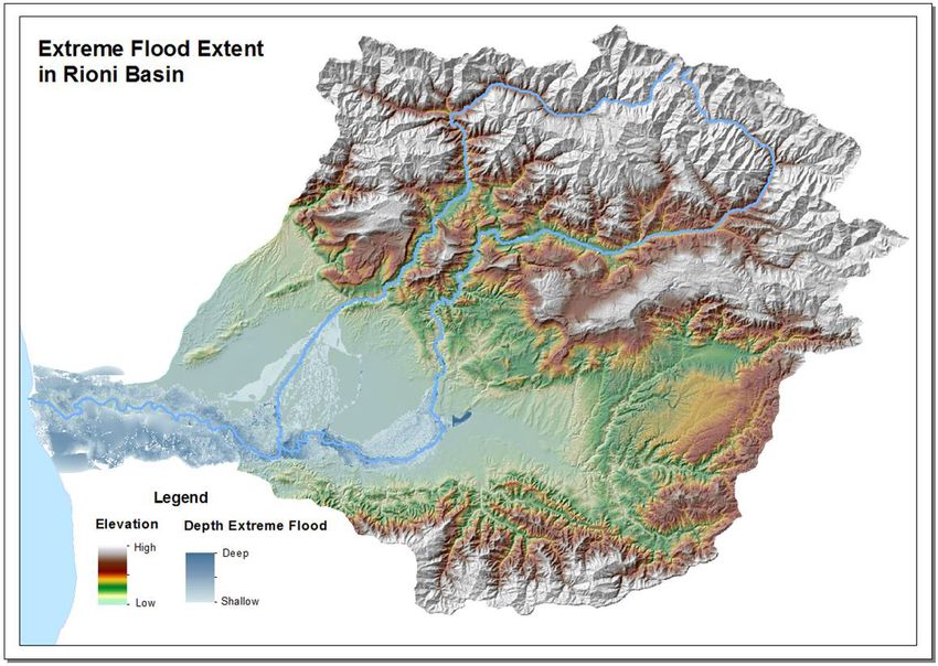
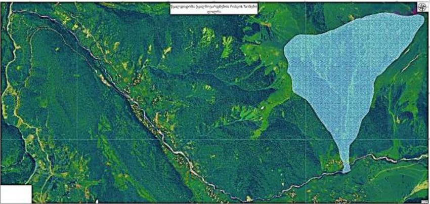
Floods and flash floods: The NEA lacks large-scale maps on high-probability floods, flash
floods, flood depth, flow velocity and direction. These are lacking due to: i) a shortage of
hydrometeorological (rainfall, peak discharges, water elevation/level), geodetic and geo-
logical data on river channel and floodplains as a result of limited hydrometeor-ological
and geological monitoring and field surveys; ii) limited weather modeling capacities; iii)
limited hydrological modeling capacities (a lack of models for major river basins, except
for the Rioni River basin and the left tributaries of Alazani River basin), stemming from a
lack of hydrographs for smaller watersheds due to the lack of data on watershed physical
features/parameters and a lack of high-resolution (5-m and higher resolution) DEMs; iv) lim-
ited hydrodynamic/hydraulic modeling capacities without e.g. the 1D-2D/MIKE Basin-based
hydraulic models for river basins other than the Rioni River basin and catchments of the
left tributaries of the Alazani River basin, also attributable to a shortage of data on chan-
nel-floodplain hydrodynamic and topographic data and lack of a high-resolution DEM; v)
limited use of ground radar, and satellite imagery data and their integration into forecasting
and modelling platforms.
Concerning flash flood modeling, hazard maps on these are practically absent due to: i) a
shortage of real-time rainfall monitoring data; and ii) a lack of data on soil moisture, slope
and soil permeability/drainage.
Glacier retreat: The NEA has limited experience in developing glacier hazards maps due to:
i) the lack of data on complexity of terrain, weather variables, baseline data (volume, thick-
ness), lack of the special hydrological models allowing glaciers’ dynamic modeling, limited
topographic and ice cover surveys/inventories and use of aerial photography and satellite
imagery.
Landslides: The NEA lacks up-to-date large-scale maps on landslide hazards due to: i)
a shortage of data on meteorology (e.g. rainfall etc.) geology, topography, hydrology and
vegetation cover, that can be attributed to limited hydrometeorological and geological moni-
toring and field surveys, and also to the limited use of software and knowledge of numerical
models (e.g., the Swiss-based RAMMS).
Mudflow and debris flow: The NEA lacks larger-scale (at least river basin level) mudflow
hazard maps due to: i) a shortage/lack of data on runoff coefficient, design rainfall (inten-
sity, duration and total amount of precipitation), peak discharges and amount of sediment
available for transportation, attributable to limited hydrometeorological and geological mon-
itoring, geological and geodetic surveys and use of aerial photography and satellite imag-
ery; and ii) a lack of modeling tools, knowledge and capacities in application of numerical
models.
Avalanches: The NEA has limited experience in developing avalanche maps due to: i)
the lack of data on complexity of terrain, weather variables, on-site weather (temperature,
snowfall) and snowpack (snow depth), that can also be attributed to diminished hydromete-
orological monitoring and forecasting, including snowfall and snowpack monitoring, limited
topographic and snow cover surveys/inventories and use of aerial photography and satel-
12lite imagery; and ii) a lack of numerical computer models (e.g.
RAMMS) and capacities to run such models.
Droughts: Only large-scale drought maps are available in the
Hazard Web-Atlas, although even these are outdated. Up-to-
date maps, both large- and small-scale ones are not current-
ly produced due to: i) the lack of data on meteorological (e.g.
rainfall, air temperature, relative humidity, wind velocity, solar
radiation) and hydrological (e.g. discharge/streamflow) parame-
ters, that can again be attributed to limited hydro-meteorological
monitoring; ii) the lack of agrometeorological data (e.g. evapo-
trans-piration, soil moisture, leaf wetness, phenology etc.), also
attributable to extremely limited agrometeorological monitoring;
and iii) a lack of knowledge and capacities for deriving various
drought indices.
Strong winds: Up-to-date strong wind hazard maps are not avail-
able, due to: i) the shortage of real-time meteorological data
attributed to limited hydrometeorological monitoring; ii) limited
weather forecasting/modeling (Numerical Weather Prediction
Models) capacities; iii) limited use and integration of ground ra-
dar, lightening and satellite imagery data into existing forecast-
ing/modelling platforms.
Thunderstorms and hailstorms:up-to-date thunderstorm and
hail hazard maps are not available, due to: i) the shortage of re-
al-time meteorological data (e.g. rainstorms, thunderstorms, air
temperature, etc.) attributed to limited hydrometeorological mon-
itoring; ii) limited weather forecasting/modeling (NWP -Numerical
Weather Prediction Models) capacities; iii) absent ground-based
lightening networks and limited use and integration of ground ra-
dar and satellite imagery data into existing forecasting/modelling
platforms.
Multi-hazard mapping. The NEA does not practice multi-hazard
mapping; however, there is some limited experience in this realm in
the NGO sector.
Knowledge gaps and needs of local academic and research in-
stitutions, NGOs and private consulting companies in hazard
mapping. There is very limited experience of climate-induced hazard
mapping in the NGO, academic and local private sectors, although
many of these institutions, in particular those dealing with spatial in-
formation, GIS/RS, modeling and database management have both
a solid technical background and the geospatial technologies to carry
out hazard mapping (there are a few NGOs and universities that do
have past and current experience in hazard mapping). The abso-
lute majority of university courses on DRR provided by some of the
leading academic institutions do not include climate-induced hazard
assessment and mapping, including any on multi-hazard mapping.
Recommended The recommended actions (road map) at the end of this document cover
actions the period 2018-2023 to address gaps and meet needs in climate-induced
hazard mapping. Each action is linked with relevant capacity gap(s)/
need(s), international obligations, national statutory and policy require-
ments, responsible parties, potential source(s) of financing/donor(s), and
approximate cost and timeframe.
13 According to cost criteria, actions are divided into low (up to 100 000 USD), medium (100 000-
1 000 000 USD) and high (above 1 000 000 USD) cost categories. In terms of timeframe, actions
are divided into short-term (up to one year), mid-term (up to three years) and longer-term (three to
five years) categories.
The road map is a wide menu of non-structural measures that are grouped into the following three
major categories: i) hazard assessment and mapping methodologies; ii) hazard databases/maps
and data accessibility; and iii) hazard assessment and mapping practices.
The recommended actions focus on all of the following:
Developing and adopting a regulation on EU-compliant flood assessment and mapping meth-
odology;
Developing and adopting a regulation on an international standards-based multi-hazard assess-
ment and mapping methodology;
Building knowledge and capacities of public authorities, primarily the NEA and local govern-
ments, as well as the non-public sector (e.g. research and academic community, NGOs and
private consulting companies), representatives in application of international standards-based
flood and multi-hazard assessment and mapping methodologies;
Updating the electronic Hazards Atlas and inclusion of more detailed geospatial data and hazard
maps therein;
Building capacities of relevant state institutions, primarily the NEA, for developing climate-in-
duced hazard maps for all types of climate-induced hazards relevant to Georgia, as well as for
detailed hazard maps;
Creating a user-friendly, electronic, climate-induced hazard database within the NEA, which
various uses can readily access;
Establishing national standards for geospatial data and maps, including hazard data and maps,
aligning hazard data and maps with these standards and linking climate-induced hazard data
and maps with a common Geospatial Portal;
Expanding and upgrading existing hydrometeorological (including snowfall and snowpack/depth
monitoring), agrometeorological and geological monitoring networks to cover all major river ba-
sins, as well as smaller watersheds with high climate-induced multi-hazard risks;
Procuring additional radars (two radars for Western Georgia, in Kutaisi and Poti) as well as
ground-level lightning (six detectors/antennas) detectors and integrating them into multi-hazard
forecasting systems;
Filling data gaps on watershed physical parameters, including land cover, channel-floodplain
topography, geodesy, geology, hydrodynamics, soil moisture, slope, drainage, rainfall runoff co-
efficient, peak discharges and amounts of sediment available for transportation, and snow pack
through:
conducting an inventory and processing historic hydrometeorological, agrometeor-ological
and geological data;
intensifying field geological, geodetic, hydrological and snow cover surveys;
procuring/developing a high-resolution DEM; and
acquiring and effectively integrating radar, ground-based lightning detectors, aerial photog-
raphy and satellite imagery data into multi-hazard forecasting and modeling platforms.
Characterizing nearly all Georgian glaciers based on complex integrated use of high-quality
satellite monitoring, along with rich historical data, current field data and expert knowledge;
implementation of the quality assessment/quality control (QA/QC) procedures to obtain highly
accurate and high-quality results;
Carrying out research to determine current/recent regional climate change impacts on glaciers:
14 Definition of large glaciers’ retreat and changes of small glaciers’ depth/volume;
Determination of glaciers’ degradation dynamics according to climate change scenarios
based on hydrological modelling;
Estimation of potentially existing fresh water resources contained in the glaciers; and
Determination of glacial runoff share in the country’s water balance and its evolution through
time.
Purchasing advanced numerical weather forecasting, hydrological, hydraulic, landslide, mud-
flow, avalanche and glacial melting models and training the NEA’s staff in applying such models;
Developing/calibrating hydrological, hydraulic (1D-2D/MIKE Basin), landslide, mudflow and av-
alanche models for all major river basins, as well as for sub-basins/smaller watersheds of river
basins with high climate-induced multi-hazard risks; e.g., smaller watersheds of the Kura River
Basin within the boundaries of the city of Tbilisi;
Setting up near-real-time fully integrated flood/flash flood, landslide, mudflow/debris flow, ava-
lanche, drought, strong wind, thunderstorm and hail forecast platforms for all major river basins,
as well as for sub-basins/smaller watersheds of river basins with high multi-hazard risks, and
integrating various-scale weather forecasting models and all available data into these, including
monitoring, radar, ground-based lightning network and satellite data;
Selecting and calculating proper drought indices and developing drought hazard maps: the NEA
has lengthy historical data sets on daily (and sub-daily in some cases) precipitation and tem-
perature from old stations, and a review of these data, particularly in the drought-prone regions
should determine which indicator(s) should be used to calculate drought susceptibility. A drought
indicator should be calculated for each grid cell within the model and for each month within the
year, resulting in a drought hazard map by month and a drought susceptibility map. The results
should be calibrated based on observed droughts, in particular the drought of 2000.
Developing flood, flash flood, landslide, mudflow/debris flow, avalanche, drought, strong wind,
thunderstorm and hail hazard maps, as well as climate-induced multi-hazard maps for all major
basins, as well as for sub-basins/smaller watersheds with high multi-hazard risks;
Building the NEA’s and other stakeholders capacities in multi-hazard assessment and mapping,
based on commonly-agreed, international standards-based methodology(-ies); and
Developing university courses on international standards-based multi-hazard assessment and
mapping.
15 1.0 This study “Assessment of Hazard Mapping System in Georgia and rec-
ommended actions (road map)” was developed under the inception phase
Objective, of the Project “Strengthening the Climate Adaptation Capacities in Geor-
scope and gia”, and implemented by the UNDP Country Office in Georgia with finan-
cial support from the Swiss Agency for Development and Cooperation
methodology of
(SDC).
the study
The primary objective of the study is to assess the existing hazard map-
ping architecture in Georgia, including current capacities and gaps, and
based on this develop a capacity building action plan (road map) for the
country to fill the gaps and meet existing capacity needs in hazard map-
ping.
This report is composed of following parts:
stakeholder analysis to identify relevant entities from national and lo-
cal governments, international and local non-governmental organiza-
tions, civil society organizations and academia engaged in hazards
mapping;
assessment of the institutional and legal set-up for hazard mapping
in Georgia and progress achieved in approximating EU standards,
existing practices, gaps and technical (including financial) and human
capacities for hazard mapping; and
An action plan (Road Map) for the period covering 2018-2023, with
required actions for enhancing hazard mapping capacities, in relation
to the identified hazards.
The assessment only addresses mandates and capacities of stakehold-
ers engaged in mapping of climate-induced natural hazards such as
floods, flash floods, mudflows, rockfalls, avalanches, strong winds, hail-
storms and, droughts etc. Furthermore, the study geographically focusses
on the entire country, as well as regions except for the Adjara Autonomous
Republic, which is covered by another consultancy assignment commis-
sioned by the UNDP Inception Phase of the project and funded by the
Objective, scope and methodology of the study
SDC.
This report was developed by applying the following methodology:
Conducting of a desk review and analysis of previously prepared stud-
ies/reports and, in particular, the feasibility study of the UNDP/SDC/
GCF project “Scaling-up Multi-Hazard Early Warning System and the
Use of Climate Information in Georgia” (hereafter UNDP/SDC/GCF
MHEWS project), and the study “Consolidation of the hazard mapping
methodology and assessment of the legal framework for its applica-
tion” carried out by Geographic with SDC’s assistance under the CSO
DRR project in Georgia;
Conducting of a second desk review of the relevant current legal-reg-
ulatory, policy and institutional setting in the area of hazard mapping;
Deriving information from interviews held with institutions engaged in
hazard mapping;
Preparation of a capacity gap analysis against international commit-
ments and national statutory requirements; and
Stakeholder consultations.
162.0 2.1 International commitments
Sendai Framework. Georgia is a party to the Sendai Framework for Di-
Legal- saster Risk Reduction (2015-2030), adopted at the Third UN World Con-
regulatory and ference on Disaster Risk Reduction in Sendai, Japan, on 18 March 2015.
policy framework The first priority under this Global DRR Platform is “Understanding di-
for hazard saster risk”, which among other issues includes hazard assessment and
mapping mapping.
Convention on Access to Information, Public Participation in Decision-Mak-
ing and Access to Justice in Environmental Matters (Aarhus Convention).
Georgian is a party to the Aarhus Convention, one of the major objectives
of which is to provide the right to every person to receive environmental
information that is held by public authorities (“access to environmental in-
formation”). This includes information on the state of the environment, but
also on policies or measures taken, and on the state of human health and
safety where this can be affected by the state of the environment.
Association Agreement between the European Union and the European
Atomic Energy Community and their Member States of the one part, and
Georgia (EUAA). Article 301 of EUAA states that “The Parties shall de-
velop and strengthen their cooperation on environmental issues, thereby
contributing to the long-term objective of sustainable development and
greening the economy. It is expected that enhanced environment protec-
tion will bring benefits to citizens and businesses in Georgia and in the
EU, including through improved public health, preserved natural resourc-
es, increased economic and environmental efficiency, as well as use of
modern, cleaner technologies contributing to more sustainable production
patterns. Cooperation shall be conducted considering the interests of the
Parties on the basis of equality and mutual benefit, as well as taking into
account the interdependence existing between the Parties in the field of
Legal-regulatory and policy framework for hazard mapping
environment protection, and multilateral agreements in the field.”
Article 230 of the EUAA calls for implementation of the Aarhus Conven-
tion, including the provisions related to access to information.
According to Article 302 of the EUAA, “Cooperation shall aim at preserv-
ing, protecting, improving and rehabilitating the quality of the environment,
protecting human health, sustainable utilization of natural resources and
promoting measures at international level to deal with regional or global
environmental problems, including in the areas of:
(302.a) environmental governance and horizontal issues, including
strategic planning, environmental impact assessment and strategic
environmental assessment, education and training, monitoring and
environmental information systems, inspection and enforcement,
environmental liability, combating environmental crime, trans-bound-
ary cooperation, public access to environmental information, deci-
sion-making processes and effective administrative and judicial re-
view procedures;
(302.c) water quality and resource management, including flood risk
management, water scarcity and droughts as well as marine environ-
ment.”
The EUAA’s Annex XXVI sets concrete targets and timelines for the trans-
position/approximation of environmental laws, institutions and manage-
ment systems to relevant EU directives in the realm of the environment.
17 Under this Annex, there are the following concrete targets for adoption and implementation of the
EU Flood Directive:
“Directive 2007/60/EC of the European Parliament and of the Council of 23 October 2007 on the
assessment and management of flood risks
The following provisions of that Directive shall apply:
adoption of national legislation and designation of competent authority(ies). Timetable: those
provisions of that Directive shall be implemented within four years of the entry into force of this
Agreement.
undertaking preliminary flood assessment (Articles 4 and 5). Timetable: those provisions of that
Directive shall be implemented within five years of the entry into force of this Agreement.
preparation of flood hazards maps and flood risks maps (Article 6). Timetable: those provisions
of that Directive shall be implemented within seven years of the entry into force of this Agree-
ment.
establishment of flood risk management plans (Article 7). Timetable: those provisions of that
Directive shall be implemented within nine years of the entry into force of this Agreement.“
The EU Directive on Flood Assessment and Management does not give a detailed methodology nor
criteria for flood hazard assessment. Instead, it sets general criteria for hazard mapping to depict:
1. flood extent;
2. water depths or water level, as appropriate; and
3. where appropriate, the flow velocity or the relevant water flow.
It requires hazard assessments and mapping at the River Basin District level, which may or may not
coincide with natural hydrological boundaries of river basins; e.g., several river basins can be com-
bined for river basin planning and management purposes, as defined by the EU Water Framework
Directive.
There is a guidance document on reporting under the Flood Directive, which includes specifications
for preparing flood hazard maps3. More specifically, it allows for Member States to choose different
scales of maps depending on the type of maps and floods although, in the EU’s WISE (Water Infor-
mation System for Europe) system, mostly 1:250 000 maps are accepted and readily available.
Flood hazard maps must show the geographical area that could be flooded under different scenari-
os. The flood maps must be prepared for the following flooding scenarios:
floods with low probability, or extreme event scenarios;
floods with a medium probability (likely return period ≥ 100 years); and
floods with a high probability, where appropriate.
Member States have the flexibility to assign specific flood probabilities to these scenarios. For each
scenario, Member States must prepare information on flood extents and water depth or levels.
Where appropriate, Member States could also prepare information on flow velocities or the relevant
water flow.
The maps may show other information that Member States consider useful, such as the indication
of areas where floods with a high content of transported sediments and debris floods can occur, and
information on other significant sources of pollution. For coastal flooding where there is an adequate
level of protection in place, and for groundwater flooding, Member States can decide to limit the
preparation of flood hazard maps to low probability or extreme events.
3 Source: Guidance for Reporting under the Floods Directive (2007/60/EC). Guidance Document No. 29. A compilation of reporting
sheets adopted by Water Directors Common Implementation Strategy for the Water Framework Directive (2000/60/EC). https://
circabc.europa.eu/sd/a/acbcd98a-9540-480e-a876-420b7de64eba/Floods%20Reporting%20guidance%20-%20final_with%20re-
vised%20paragraph%204.2.3.pdf
18Each Member State should also report through the WISE system the following: 1. Summary (< 10 000 characters) on methods used to identify, assess or calculate: flooding extent (including resolution of digital terrain models); flooding probabilities (including information as to why particular probabilities have been selected) or return periods; depths or water levels; velocities or flows (where appropriate); models used, data sets, uncertainties, if - and if so how - climate change has been taken into account in the mapping; 2. Where particular flood scenarios have been omitted, summary (
Law on Emergency Situations as amended in 2017;
Law of Georgia on Civil Safety (2014) as amended in 2017;
Law of Georgia on the Procedure of Planning and Coordination of National Security (2015);
Resolution #262 of the GoG dated 9 October 2013 on Setting up the Governmental Commission
for the Creation and Development of Spatial Data Infrastructure;
Government resolution on National Action Plan for the Implementation of the Association Agen-
da between Georgia and the European Union (approved annually by a governmental decree);
Resolution #508 of the GoG on Approval of Civil Security National Plan, dated 24 September
2015;
Order #2-255 of the Minister of Environmental Protection and Agriculture (MoEPA) of Georgia on
Approval of the Regulations of the Legal Entity of Public Law - National Environmental Agency,
dated 19 April 2018; and
Government Resolution # 4 on Approval of National DRR Strategy (2017-2020) and Action Plan.
According to the Law of Georgia on Structure, Powers and Operational Procedure of the Govern-
ment of Georgia (2004), the following falls within the terms of reference of the Government: setting
key tasks, duties and operational procedures for the executive authorities with a view to prevention of
emergencies or reaction thereto (Article 20b). Among various measures response activities includes
preparation of an emergency risk map, division of the territory of Georgia and cities into groups and
organizations according to categories (Article 28.2b). This stipulation of the law means that the risk
map is a set of interdisciplinary databases, which embodies all predictable risks (industrial risks,
natural calamities, spread of epidemics etc.) that may lead to or cause an emergency situation. The
map of natural disaster hazards is an integral part of the emergency risk map. Thus, the preparation
of the emergency risk map is one of the decision-making instruments for prevention and response.
Obligations related to preparation, maintenance and use of the risk map should be defined by the
GoG in a related resolution.
Pursuant to the Law of Georgia on the Procedure of Planning and Coordinating National Security,
one of the fields of national security policy is environmental and energy safety, which includes but is
not limited to detection, identification, assessment and prediction of ecological and energy hazards,
risks and challenges. According to the same Law, the nation-wide conceptual documents are:
a) National security concept;
b) Georgia’s risk assessment paper; and
c) National strategies in security field.
According to the Laws of Georgia on Civil Safety, a National Civil Safety Plan should be developed.
In an ideal case, a disaster risk assessment and related map including hazards should be an integral
part of the given plan.
According to the Law of Georgia on Basic Principles of Spatial Arrangement and City Planning,,
competent authorities are obliged to develop:
National Master Plan on Spatial Arrangement;
Master Plans of autonomous republics (e.g. Adjara and Abkhazia);
Municipal Spatial Arrangement and Development Plans; and
Urban/City Development Plans, composed of: i) a Land Use Master Plan (also including land
use zoning maps); and ii) a Construction/Development Regulation Plan.
The above law allows for an exceptional (restricted) regime of regulation for certain territories with
special spatial arrangement status, which is assigned to the territory based on various socio-eco-
nomic and environmental criteria, including risks of natural disasters.
20You can also read