AP Human Geography Bootcamp: Summer Assignment 2021
←
→
Page content transcription
If your browser does not render page correctly, please read the page content below
AP Human Geography Bootcamp: Summer Assignment 2021
         Welcome to one of the most relevant learning experiences of
your high school career! Many students take this course without any real
understanding of what geography is, exactly… something to do with maps?
While maps are one of a geographer’s many useful tools, geography is so
much more than memorization of place locations. AP Human Geography is
sometimes described as the “why of where”. It is the systematic study of
patterns and processes that have shaped human understanding, use, and
alteration of Earth’s surface. Simply put, geographers seek to explain why
the world is the way it is today, and why things happen where they
happen. Pretty neat, huh?

Summer Work Overview

Your summer work will allow you to build a foundation in geographic concepts that will enable you to be successful
in AP Human Geography. Your summer work is designed to meet three major objectives. Your requirements to
meet each of these objectives will be described on the pages that follow. The objectives of the AP Human
Geography Summer Work are:
1. To establish a habit of keeping up with current events and connecting them to course concepts.
2. To familiarize you with locational geography—where things are!
3. To critically analyze major themes in Geography and to prepare for collegiate discussions using the Harkness
method (a tool that will be used often in this class).

Guidelines and Formatting Requirements (SEE GRADING RUBRIC on pg. 4)
1. All PHYSICAL work (Objectives 1 and 3 below) is due on the first day of class—no exceptions or excuses. As per
BMC policy no late work is accepted in AP classes, and a grade of zero will be given to any missing portions.
Objective 2 will be quizzed on the second day.
2. PRINT OUT a copy of the packet to annotate/highlight.
3. Type ALL written assignments into one word document denoting which Reading/Assignment each comes from.
Use Times New Roman, in 12-pt size, 1” margins, single spaced.
4. TURN IN you’re a) written assignments document and b) log (see Objectives One and Three below) to your
teacher on the first day of class. You will submit this PHYSICALLY on the first day, and you must save a DIGITAL
COPY to your iPad which you will be taught how to submit to Schoology/TurnItIn in class on the first day.
5. Your summer work must be your own unique creation. Copying from any source—written work, online
resources, or a classmate—is plagiarism and will result in an automatic zero for the entire assignment and
disciplinary action through the Dean’s Office.
*If You have any questions please feel free to email me at mcaninchb@bishopmoore.org. Please remember to cc a
parent to any email to a teacher as I cannot respond otherwise.

Citation: Fouberg de Blij; Human Imprint; Katz, Rik; Postlethwaite, Jessica Robson;

                                                                                                                  1
Objective 1: Current Events
        In AP Human Geography, you will strive to understand the role
people play in making places, see the geographic context in which
major issues occur, think critically about the world, and appreciate the
complexities of globalization. You will make connections with the
world around you and learn to think spatially when seeking to answer
some of the most meaningful questions facing the world today. To
understand all of this, you must have strong knowledge of what’s
happening in the world around you!
        There are many ways in which you can keep track of world
events: you can watch the news, listen to the radio, read newspapers,
follow your favorite news organization on Facebook (NEWS
ORGANIZATIONS NOT BLOGS OR CLICK BAIT), or subscribe to Twitter or
RSS feeds. Here are some suggested websites:

www.nytimes.com                    www.csmonitor.com                   www.npr.org
www.latimes.com                    www.chron.com                       www.economist.com
www.slate.com                      www.cnn.com                         www.bbc.com
http://america.aljazeera.com/      https://www.ap.org/en-us/           http://www.reuters.com/

To complete this portion of your summer work, you will find 4 events (local, national, and
international). You will fill out the attached log for these events. Our goal is not to become foreign
policy experts… Rather, we seek to build a habit of global awareness! This log can be found in this
packet on Page 6.

Objective 2: Locational Geography
        In order to understand the “why of where”, you must know
where things are! Every test you take in this class will include questions
that assume a level of geographic knowledge. You will have a series of
map tests over the course of the year based on packets of information to
build your geographic background knowledge. Your first map test will be
on the second day of class and will include basic geographic information
as specified by the College Board in the AP Human Geography Course
Description.

                                                                                                     2
Objective 3: Introduction to Major Topics of Course and Analysis of
Material.
        Throughout your time at Bishop Moore and in college you will be expected to analyze
material and use it towards organized discussions (seminars, debates, etc.). In my class, as well as
others as Bishop Moore we will be utilizing this as a
tool for students work as a team to analyze
information, make connections across material, and
arrive at deeper understandings of core concepts; all
of which are CENTRAL to success in the AP program.
One of our earliest assignments will be an
introductory discussion based on a series of articles
meant to help us dive into the major unit themes of
AP Human Geography as delineated by the College
Board. Further down in the packet you will see an
assignment based on a series of articles and video
clips which for now you will read, annotate/note take,
and answer questions from in preparation for this
assignment.

                           Summer Assignment Directions
Objective 1: Current Events – Assignment (pg. 5): Using the current events chart use a variety of
REPUTBALBE sources (see good example sources on page 3 of this packet) and read 4 articles pertaining
to DIFFERENT events that must be in varying locations from local to global. For each one you will
identify the source, title of article and link to it, location, and a 1-2 sentence summary that brings across
the main idea of the article. TURN THIS IN FIRST DAY OF CLASS.

Objective 2: Locational Geography – Assignment (pp. 6-7): Using the attached blank maps and the
checklist (found in this packet on pp. 7) fill them out, and study for your map quiz on the second day of
class. YOU DO NOT NEED TO TURN THIS IS AS YOU MAY STUDY FROM IT.

Objective 3: Introduction to Major Topics of the Course and Analysis of Material – Assignment: On the
following pages (found in this packet on pp. 8-40) you will find a series of articles, book excerpts, video
links, and interview requests. They are organized in Assignments 1-8. Each one was chosen for a
reason, and each relates to 1 or more of the units we’ll study throughout the year. Read and annotate
the copy that you print out. Then answer the attached questions for each task (most in paragraph
form). As stated in the instructions on pg. 1 please TYPE ALL ANSWERS on one word document which
you will print and turn in on the first day. When answering the questions, please try not to quote
heavily. I don’t simply want you to find the key words and repeat them. TURN THIS IN FIRST DAY OF
CLASS.

                                                                                                            3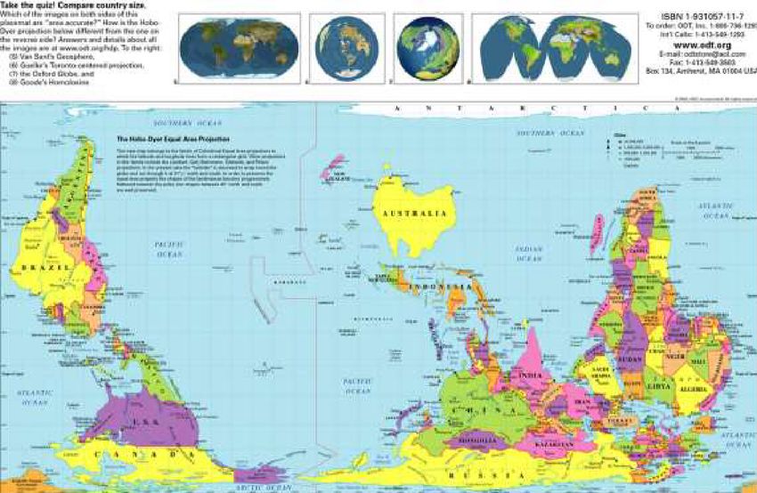
AP Human Geography Summer Work 2021 Grading:                                 ________ /100
 Objective                                         Points Awarded   Comments
    1) Current Events Log (pg. 5)
    -   4 current events (5 points each)
    -   Variety of sources
    -   Variety of locations                       _____/20
    -   Relevant summaries that capture the
        main idea

    2) Locational Geography (pp. 6-7)
                                                   _____/30
    -   Identified all locations required on the
        AP regions map. Points based on Map
        Quiz Score.

    3) Articles and Questions (pp. 8-40)
    -   Read/watch/interview and afterwards
                                                   _____/40
        adequately/fully answer the questions
        after each reading in full sentence and
        paragraph format.

    4) Organization/Quality
                                                   _____/10
    -   Work is organized and neat, easy to
        read, clearly followed formatting
        directions (on pg. 1 of packet)

   ● Please note plagiarized work will earn a ZERO and will result in disciplinary action with the
     Dean’s Office.
Your summer work will count as an Alternate Assessment grade for the 1st quarter. Remember
that you will take a map test on the second day of school, so be sure to study!

                           Be curious about the “why of where”!
                                      Have a great summer

                                                                                                     4
APHG Summer Work 2021: Current Events Log

Note that articles must pertain to the week in which they are cited. Articles should come from a variety
of sources and pertain to a variety of locations, from local to global. WRITE answers in the frame.

 Date                  Source (CBC,      Article Title         Location of      One-Sentence Summary
                       CNN, NYT)                               Event

 1

 2

 3

 4

                                                                                                           5
6
AP Regions Map Identification
 Use the course description pg. 16 (LINK HERE) and other resources to help you. The maps can
                                       be found on pg. 16.

Regions.                                          ____ Oceania
____Africa                                        ____ Polynesia
____Antarctica                                    ____ Russian Federation
____Asia                                          ____ Siberia
____Australia                                     ____ South America
____ Brazil                                       ____ South Asia
____Canada                                        ____ Southeast Asia
____ Caribbean                                    ____ Southern Africa
____Central Africa                                ____ Sub-Saharan Africa
____ Central America                              ____ United States
____ Central Asia                                 ____ West Africa
____ East Africa                                  ____ Western Europe
____ Eastern Europe
____ Europe                                       Demarcations (Draw them on)
____ Latin America                                ____ Equator
____ Melanesia                                    ____ International Dateline
____ Micronesia                                   ____ Prime Meridian
____ Middle East                                  ____ Tropic of Cancer
____ North Africa                                 ____ Tropic of Capricorn
____ North America

                                                                                               7
Objective 3 Assignments and Questions
*Before each article I have given you some context as to how each article relates to things we’ll
study. Please read this over BEFORE reading the article. In some cases I’ve also included some extra,
supplemental things in case you’re interested. You will find the questions after each source.

Reading # 1 - Globalization
One of the major themes of the course is the topic of globalization – a term that is used very often and
has multiple meanings. For our purposes, let’s define globalization as the interconnectedness of
different places in the world. This means that various places on Earth that were once isolated from
one another now interact, sometimes on a daily basis. This interaction can be between individuals
(imagine 2 people in different countries communicating via Twitter or Facebook) or between countries
in one of the following ways:
· Economic (trade, multi-national corporations like McDonald’s or Wal-Mart)
· Political (warfare, organizations like the United Nations, NATO, or the
European Union)
· Social/Cultural Elements/Values (clothing, music, social media, language, food, and other cultural
elements)
Now read the following article, “How India Became America” (New York Times) and answer the
questions based on the description above and the article:

                                                                                                       8
1.) How India Became America
By AKASH KAPUR (New York Times - March 9, 2012)

Shoppers in the Express Avenue mall, the largest in Chennai.

Pondicherry, India
ANOTHER brick has come down in the great wall separating India from the rest of the world. Recently,
both Starbucks and Amazon announced that they would be entering the Indian market. Amazon has already
started a comparison shopping site; Starbucks plans to open its first outlet this summer.

As one Indian newspaper put it, this could be “the final stamp of globalization.”

For me, though, the arrival of these two companies, so emblematic of American consumerism, and so
emblematic, too, of the West Coast techie culture that has infiltrated India’s own booming technology sector,
is a sign of something more distinctive. It signals the latest episode in India’s remarkable process of
Americanization.

I grew up in rural India, the son of an Indian father and American mother. I spent many summers (and the
occasional biting, shocking winter) in rural Minnesota. I always considered both countries home. In truth,
though, the India and America of my youth were very far apart: cold war adversaries, America’s capitalist
exuberance a sharp contrast to India’s austere socialism. For much of my life, my two homes were literally —
but also culturally, socially and experientially — on opposite sides of the planet.

All that began changing in the early 1990s, when India liberalized its economy. Since then, I’ve watched
India’s transformation with exhilaration, but occasionally, and increasingly, with some anxiety.

I left for boarding school in America in 1991. By the time I graduated from high school, two years later,
Indian cities had filled with shopping malls and glass-paneled office buildings. In the countryside, thatch huts
had given way to concrete homes, and cashew and mango plantations were being replaced by gated

                                                                                                               9
communities. In both city and country, a newly liberated population was indulging in a frenzy of
consumerism and self-expression.

More than half a century ago, R. K. Narayan, that great chronicler of India in simpler times, wrote about his
travels in America. “America and India are profoundly different in attitude and philosophy,” he wrote.
“Indian philosophy stresses austerity and unencumbered, uncomplicated day-to-day living. America’s
emphasis, on the other hand, is on material acquisition and the limitless pursuit of prosperity.” By the time I
decided to return to India for good, in 2003, Narayan’s observations felt outdated. A great reconciliation had
taken place; my two homes were no longer so far apart.

This reconciliation — this Americanization of India — had both tangible and intangible manifestations. The
tangible signs included an increase in the availability of American brands; a noticeable surge in the population
of American businessmen (and their booming voices) in the corridors of five-star hotels; and, also, a striking
use of American idiom and American accents. In outsourcing companies across the country, Indians were
being taught to speak more slowly and stretch their O’s. I found myself turning my head (and wincing a little)
when I heard young Indians call their colleagues “dude.”

But the intangible evidence of Americanization was even more remarkable. Something had changed in the
very spirit of the country. The India in which I grew up was, in many respects, an isolated and dour place of
limited opportunity. The country was straitjacketed by its moralistic rejection of capitalism, by a lethargic and
often depressive fatalism.

Now it is infused with an energy, a can-do ambition and an entrepreneurial spirit that I can only describe as
distinctly American. In surveys of global opinion, Indians consistently rank as among the most optimistic
people in the world. Bookstores are stacked with titles like “India Arriving,” “India Booms” and “The Indian
Renaissance.” The Pew Global Attitudes Project, which measures opinions across major countries, regularly
finds that Indians admire values and attributes typically thought of as American: free-market capitalism,
globalization, even multinational companies. Substantial majorities associate Americans with values like hard
work and inventiveness, and even during the Iraq war, India’s views of America remained decidedly positive.

I HAVE learned, though, that the nation’s new American-style prosperity is a more complex, and certainly
more ambivalent, phenomenon than it first appears. The villages around my home have undeniably grown
more prosperous, but they are also more troubled. Abandoned fields and fallow plantations are indications of
a looming agricultural and environmental crisis. Ancient social structures are collapsing under the weight of
new money. Bonds of caste and religion and family have frayed; the panchayats, village assemblies made up of
elders, have lost their traditional authority. Often, lawlessness and violence step into the vacuum left behind.

I recently spoke with a woman in her mid-50s who lives in a nearby village. She leads a simple life
(impoverished even, by American standards), but she is immeasurably better off than she was a couple of
decades ago. She grew up in a thatch hut. Now she lives in a house with a concrete roof, running water and
electricity. Her son owns a cellphone and drives a motorcycle. Her niece is going to college.

But not long before we talked, there had been a murder in the area, the latest in a series of violent attacks and
killings. Shops that hadn’t existed a decade ago were boarded up in anticipation of further violence; the police
patrolled newly tarred roads. The woman was scared to leave her home.

“This is what all the money has brought to us,” she said to me. “We were poor, but at least we didn’t need to
worry about our lives. I think it was better that way.”

Hers is a lament — against rapid development, against the brutality of modernity — that I have heard with
increasing frequency. India’s Americanization has in so many ways been a wonderful thing. It has lifted
millions from poverty, and, by seeding ideas of meritocracy and individual attainment into the national

                                                                                                               10
imagination, it has begun the process of dismantling an old and often repressive order. More and more,
though, I find myself lying awake at night, worrying about what will take the place of that order. The
American promise of renewal and reinvention is deeply seductive — but, as I have learned since coming back
home, it is also profoundly menacing.
Akash Kapur is the author of the forthcoming “India Becoming: A Portrait of Life in Modern India.”
Reading 1 Question:
Answer the following in 1 paragraph…
How does the title of the article itself describe the idea of globalization? Describe in detail the different
ways that the author claims that India is becoming more Americanized (this is spoken about throughout
the entire article). Based on the article and your own feelings, describe how globalization of culture
(being exposed to different types of food, clothing, religions, languages, technology, dress, etc.) can be
both positive and negative for individuals and their cultures.
Reading # 2 – Religion
Unlike a history course where one just memorizes the beliefs and origins of religions,
geographers study the following themes:
· Why some religions are designed to appeal to people throughout the world, whereas
others remain appealing to only people in a small geographic area.
· Why religious values are essential to understanding the meaningful ways people
organize the physical and cultural landscape (building of monuments, churches,
etc.).
· Why, unlink other cultural elements like language, migrants (people who move from
one place to another) retain their religion while often abandoning other cultural
elements.
· How and why certain religions are diffusing (spreading) faster than others, in
differing areas of the globe.
· The role the physical environment
plays in the development of certain
religions.
· Conflicts and divisions between and
among religious groups.
Now, read the prologue from the
book “The Tenth Parallel: Dispatches
from the
Fault Line Between Christianity and
Islam” and answer the questions that follow.
11“The Tenth Parallel: Dispatches from the Fault Line between
Christianity and Islam” (Eliza Griswold: 2010, Prologue)
@elizagriswold (Twitter)
“I wanted to see how Christianity and Islam are actually lived
everyday by huge numbers of vulnerable, marginal believers –
individualswho are also part of the global story of poverty,
development,climate-change forecasts, and so on…to go where
such lives are actually led, where wars in the name of religion are
not Internet media campaigns…but actual wars fought from
village to village and street corner to street corner.”
Prologue:
The tenth parallel is the horizontal band that rings the earth seven hundred miles north of the equator.
If Africa is shaped like a rumpled sock, with South Africa at the toe and Somalia at the heel, then the
tenth parallel runs across the ankle. Along the tenth parallel, in Sudan, and in most of inland Africa,
two worlds collide: the mostly Muslim, Arab-influenced north meets a black African south inhabited
by Christians and those who follow indigenous religions—which include those who venerate ancestors
and the spirits of animals, land, and sky.1 Thirty miles south (at a latitude of
9°43'59"), the village of Todaj marked the divide where these two rival worldviews, their dysfunctional
governments and well-armed militaries, vied inch by inch for land. The village belonged to the south’s
largest ethnic group, the Ngok Dinka. But in 2008, when Roger Winter paid
Nyol Paduot a visit, the north was threatening to send its soldiers and Arab militias to attack the village
and lay claim to the underground river of light, sweet crude oil running beneath the chief ’s
feet.
12Oil was discovered in southern Sudan during the 1970s, and the struggle to control it is one of the
long-running war’s more recent causes. The fight in Sudan threatened to split Africa’s largest
country in two, and still does. In 2011, the south is scheduled to vote on whether it wants to remain
part of the north or become its own country, made up of ten states that lie to the south of the tenth
parallel and border Ethiopia, Kenya, Uganda, the Democratic Republic of Congo, the Central
African Republic, and Chad. This looming split—which, if it happens, would likely occur largely
along the tenth parallel—meant that Todaj and the nearby oil boomtown of Abyei, about ten miles
south, were vitally important. Whichever side controlled them would control an estimated two
billion barrels of oil.
Other than Paduot, and six elders gathered in his hut, the village appeared deserted. Prompted by
gunfire and rumors of war, the five hundred families who lived there had fled south, terrified that
Todaj was about to be wiped off the face of the earth. Their fear was well founded: three times in
the previous twenty years, soldiers from the north had laid siege to Todaj, raping women and
children, killing and carrying off young men, and burning to the ground the villagers’ thatched huts
and the Episcopal Church made of hay. It was the end of the dry season, and a breeze stirred the air
over this colorless plot of parched earth, bare but for these empty dwellings and a few gaunt cows
trawling for loose hay. The cows wandering hungrily around the village didn’t belong to the people
of Todaj, but to northern Arab nomads, the Misseriya, who, because of seasonal drought up north,
came south at this time of year to graze their cattle. Paduot was afraid that when the rains began a
few weeks later, and the nomads could return home to their own greener pastures, there would be
nothing to keep the northern soldiers (cousins and sons of the nomads) from attacking Todaj.“We
know when they burn our village, they want the land,” said the chief, a Ngok Dinka translator
rendering his words into English. These patterns sounded like the ones unfolding less than fifty
13miles northwest, in the region of Darfur, because they were the same. Three decades ago, while
Sudan’s current president, Omar Hassan al-Bashir, was a military general stationed on this border,
the Khartoum-based northern government perfected the methods of attack, using the paramilitary
horsemen called the Janjawiid, whom it was now deploying in Darfur. Todaj faced this same threat,
but other than Roger Winter, very few knew anything about the impending disaster. On BBC radio,
Paduot heard much talk about Darfur. Although the same thing was happening here along the
border, it rarely made international news. The two fronts had much in common, since all of Sudan’s
wars boil down to a central Khartoum-based cabal battling the people at the peripheries. The only
differences between Darfur and Abyei, the chief explained, were religion and oil. In Darfur, there
was no oil and both sides were Muslim, a confrontation he did not understand. “Why would
Muslims fight against Muslims?” he asked aloud. Here, the north had mounted its assaults in the
name of jihad, or holy war, claiming that Islam and Arab culture should reign supreme in Sudan.
Chief Paduot, who had survived several such conflagrations, had come to see Islam as a tool of
oppression, one the northerners were using to erase his culture and undo his people’s claim to the
land and its oil. “People hate Islam now,” he said. Having stepped into the hut behind Winter, I
glanced around to see if any of the elders was startled by the chief’s remark. If they were, no sign of
it crossed their faces, which showed only dread and exhaustion. To defy the north, most of the
villagers had been baptized as Episcopalians— they prayed daily, attended church on Sunday, and
had cast off loose, long-sleeved Islamic dress in favor of short-sleeved Western-style button-down
shirts, or brilliant batiks. For them, Islam was now simply a catchall term for the government, people,
and policies of the north. Race, like religion, was a rallying cry in this complicated war.
The paler-skinned Arab northerners looked down on the darker-skinned people of the south,
Paduot explained slowly. He seemed tired of giving tutorials to outsiders. What good were earnest,
well-meaning people like us, who came with our water bottles and notebooks to record the details of
a situation but could do nothing to stop it? The divisions between north and south along the tenth
parallel date back centuries, and colonial rule simply reinforced them. One hundred years earlier, the
British colonialists who governed Sudan had virtually handed this swath of land south of the tenth
parallel to the Roman Catholic Church. Daniel Comboni, a beloved nineteenth-century Italian
missionary who was canonized as a saint in 2003, headed Catholic efforts in Central Africa with the
expressed aim to “save Africa through Africans.” Under Comboni’s direction, the Catholic Church
ran all schools and hospitals (and forbade Protestant missionaries from proselytizing), until, in 1964,
the northern government, employing Islam as a form of nationalism, expelled all missionaries from
the country. African Christians—not Westerners—were left to lead the local church, which was
then, as now, under fi re from the north as an alien, infidel institution.
This attitude has not changed, the local Catholic priest, Father Peter Suleiman, told me. “Every day
we experience the misery of the south. You still hear the promise of death.” And oil has made things
worse. “The north believes that oil is a gift from God for the Muslim people,” he said. Although the
Catholic Church still held some sway along this border, Father Suleiman told me that an influx of
more charismatic Protestant churches was gaining ground. In the village of Todaj, many of the
villagers were convinced that they were still alive solely because they had prayed to Jesus Christ for
protection.
Born into a family that prayed to ancestral gods, Chief Paduot became a nominal Muslim in order to
gain admission to school (a practice begun by Christian missionaries and now emulated by
Khartoum). Through a process of forced Islamization, the north had made it compulsory for people
14to declare themselves Muslims by saying the Shahada—“I bear witness that there is no god but God,
and I bear witness that Mohammed is his messenger”—and adopting Muslim names in order to
attend school, get a job, or avoid jail or violent death. In his forties, Paduot, chief by birth, decided
that he wanted to leave Islam and become a Catholic. But the northern security forces threatened
the local Catholic priest, one Father Marco, saying they would torture him if he baptized the chief.
(They told Paduot they’d stone him if he became “a backslider from Islam.”) He refrained from
converting to Catholicism to safeguard his village from further trouble. “I kept Islam to protect my
people,” he said, but, to show his in dependence, he had returned to the indigenous practices of his
youth—called the noble spiritual beliefs. Christians and Muslims alike disparaged the local
indigenous religion on the ground that it didn’t teach adherents to follow the one, true God. That
was ignorance on their part, Paduot said. “We worship one Creator God, too, then smaller gods.”
He had also married an Episcopalian. Now he led us out of the hut— its thick, round walls like a
muddy mushroom stem—and pointed to a line of what looked like tiny corn-husk scarecrows along
the roofs of his and other huts. “They are crosses,” the chief said. Their frayed edges glowed in the
afternoon’s pewter light; they were symbols marking the beginning of the south, and visual
reminders to anyone entering the village that it was a Christian place, the chief explained. Squinting
into the overcast sky to look at them, I thought the threadbare totems were also bids for divine
protection. Yet the crosses seemed to be proving as ineffective as the chief ’s satellite phone, which
hung by its power cord from two portable solar panels on the thatched roof of his hut. There was
no one left for him to call for help. Though his cousin, Francis Deng, was serving as the United
Nations Special Representative for the Prevention of Genocide, and though Paduot met regularly
with local UN officials, representatives of the southern government, and visitors such as Roger
Winter (a longtime head of the U.S. Committee for Refugees who had lobbied hard for the south in
Washington and Khartoum), no one could do anything to stop the impending assault.
On the surface of this conflict, two groups, northern and southern, Muslim and Christian, were
competing for land and water. Yet at a deeper level, the people were now pawns of their respective
governments, and Paduot knew it. He produced a worn map softened with use and pointed to three
annotations in English: PUMP 1, PUMP 2, PUMP 3. These indicated the oil fields of the Greater
Nile Petroleum Operating Company—a consortium of Chinese, Malaysian, Indian, and Sudanese
interests operating in Sudan with the blessing of President Bashir. At the same time, Bashir was
exhorting his holy soldiers, or Mujahideen—whom he called “the legitimate sons of the soil”—to
reup for jihad. Once again, he was making use of race and religion to safeguard oil interests before
the country faced the impending split.
Some of his soldiers were stationed two hundred yards away, acting as sentries on the north-south
border, the location of which was determined by whoever was strong enough to push it a few inches
one way or another. Around their makeshift barracks, camps of nomads were springing up, as if
preparing for war. Over the past few weeks, as Paduot looked on, the soldiers had received
shipments of automatic rifles and rocket-propelled grenade launchers. If a full-scale rift between
north and south occurred, it would begin right here with these weapons, Paduot warned. A village
sentry came in and whispered in his ear. Abruptly, he stopped talking: soldiers were slouching
against the hut’s outside wall, listening to his every word.
In Africa, the space between the tenth parallel and the equator marks the end of the continent’s arid
north and the beginning of sub-Saharan jungle. Wind, other weather, and centuries of human
migrations have brought the two religions to converge here. Christianity and Islam share a fifteen
hundred- year history in Africa. It began in 615 when Mohammed, his life at risk at home on the
15Arabian Peninsula, sent a dozen of his followers and family members to find refuge at the court of
an African Christian king in Abyssinia (modern-day Ethiopia). Within a decade of Mohammed’s
death (in 632), the first Muslim armies landed in Africa, proceeding south from Egypt to today’s
Sudan. There they made a peace pact—the first of its kind—with the ancient Nubian Christian
kingdoms along the Nile River.
The pact lasted for six centuries. Then religious wars broke out. By 1504, the last of the Christian
kingdoms in Sudan had fallen to Muslim armies. From the seventh century to the twentieth, Muslim
traders and missionaries carried Islam inland over the northernmost third of Africa, carving trade
routes from the holy city of Mecca in Saudi Arabia to the West African kingdom of Timbuktu. Away
from the coasts, crossing the landlocked region south of the tenth parallel proved difficult; the pale,
grassy savanna thickened to bush, and the bush gave way to a mire of emerald swamp and jungle.
Along the tenth parallel, the tsetse fly belt begins: and these blood-sucking insects, each the size of a
housefly and carrying African trypanosomiasis (sleeping sickness),3 virtually stopped Islam’s
southern spread.
To the east, five thousand miles off the African coast and over the Indian Ocean, natural forces also
shaped the encounter of Christianity and Islam in the Southeast Asian nations of Indonesia,
Malaysia, and the Philippines. The trade winds—high-pressure air currents that move steadily from
either pole toward the equator—filled the sails of both Muslim and Christian merchants from the
northern hemisphere beginning in the eighth century. These reliable winds propelled Christian and
Muslim ships to the same islands, beaches, and ports, then returned them either to Europe or to the
Arabian Peninsula, their ships heavy with cargoes of cinnamon and cloves.
The trade winds are part of the intertropical convergence zone, a weather system that moves to the
north or south of the equator, depending on the season. In this zone, wind currents from the
northern hemisphere run into those from the southern hemisphere. As the two cycles meet head-on,
they generate cataclysmic storms. In Asia, these storms begin during monsoon season and generally
spin west to Africa, where the most tempestuous of them move west off the African coast at Cape
Verde, across the Atlantic Ocean, and become America’s hurricanes. Within this band, Asia, Africa,
and America are part of a single weather system.4 (A dangerous year of monsoons in Asia and
storms in Africa’s catastrophe belt, for instance, can mean a disastrous year of hurricanes for the
U.S. eastern seaboard.)
As the earth grows warmer, preexisting cycles of flooding and drought around the tenth parallel
grow increasingly unpredictable, making it impossible for African nomads, most of whom are
Muslims, and farmers (Christians, Muslims, and indigenous believers) to rely on centuries-old
patterns of migration, planting, and harvesting. They must move into new territory to grow food and
graze their livestock. Consequently, between the equator and the tenth parallel two groups with
distinctly different cultures and cosmologies unavoidably face off against each other—as they do in
the Sudanese village of Todaj.
Growing populations intensify these competitions. Due to the explosive growth of Christianity over
the past fifty years, there are now 493 million Christians living south of the tenth parallel—nearly a
fourth of the world’s. Christian population of 2 billion.5 To the north live the majority of the
continent’s 367 million Muslims; they represent nearly one quarter of the world’s 1.6 billion
Muslims. These figures are an effective reminder that four out of five Muslims live outside the
Middle East. Indonesia, with 240 million people, is the most populous Muslim country in the world.
16Malaysia is its tiny, rich neighbor; the Philippines, its larger, poorer one. Together, the three
countries have a population of 250 million Muslims and 110 million Christians. Indonesia and
Malaysia are predominantly Muslim countries, with vocal Christian minorities. The Philippines—
with a powerful Catholic majority (population 92 million) mostly to the north of the tenth parallel
and a Muslim minority (population 5 million) to the south—is the opposite. It has been a strongly
Christian country ever since Ferdinand Magellan planted a cross on an island hilltop there in 1521.
Yet Islam, which arrived hundreds of years earlier, has remained a source of identity and rebellion in
the south for the past five hundred years. Africa’s and Asia’s populations are expanding, on average,
faster than those in the rest of the world. While the global population of 6.8 billion people increases
by 1.2 percent every year, in Asia the rate is 1.4 percent, and in Africa it doubles to 2.4 percent.6 In
this fragile zone where the two religions meet, the pressures wrought by growing numbers of people
and an increasingly vulnerable environment are sharpening the tensions between Christians and
Muslims over land, food, oil, and water, over practices and hardening worldviews.
The particular strain of religion that’s growing the fastest also intensifies these problems. Christianity
and Islam are in the throes of decades-long revolutions: reawakenings. Believers adopt outward signs
of devotion— praying, eating, dressing, and other social customs—that call attention to the ways
they differ from the unbelievers around them. Yet these movements are not simply about exhibiting
devotion. They begin with a direct encounter with God. For Sufi s, who make up the majority of
African Muslims, and for Pentecostals, who account for more than one quarter of African
Christians, worship begins with ecstatic experience. Sufis follow a mystical strain of Islam that
begins with inviting God into the human heart. Pentecostals urge their members to encounter the
Holy Spirit viscerally, as Jesus’s followers did during the feast of Pentecost when they spoke in
tongues. Such reawakenings demand an individual’s total surrender, and promise, in return, an
exclusive path to the one true God. “These movements aren’t about converting to a better version
of self,” Lamin Sanneh, a theologian at Yale and the author of Whose Religion Is Christianity?, told me.
“They are about converting to God.” They say the believer can know God now in this life and
forever in the next. In return, they expect the believer to proselytize—to gain new converts—from
either among other religions or their own less ardent believers, which creates new frictions.
These movements are already reshaping Africa, Asia, and Latin America—the region we used to call
the third world, or even the developing world. Nowadays, liberal and conservative Western analysts, and
many of the region’s inhabitants as well, use the term Global South instead. This somewhat clunky
moniker is intended to cast off the legacy of the West, to challenge the assumption that the entire
world is developing within a Western context. It is also meant to highlight a marked shift in
demographics and influence among the world’s Christians and Muslims. Today’s typical Protestant is
an African woman, not a white American man. In many of the weak states along the tenth parallel,
the power of these religious movements is compounded by the fact that the “state” means very little
here; governments are alien structures that offer their people almost nothing in the way of services
or political rights. This lack is especially pronounced where present-day national borders began as
nothing more than lines sketched onto colonial maps. Other kinds of identity, consequently, come
to the fore: religion above everything—even race or ethnicity— becomes a means to safeguard
individual and collective security in this world and the next one.
In many cases, then, gains for one side imply losses for the other. Revival provides not only a
pattern for daily life but also a form of communal defense, bringing people together, giving them a
shared goal or purpose, and inviting them to risk their lives in the pursuit of it. Often the end is
17liberation, and the means to liberation include martyrdom and holy war. With Islam, it is perhaps
easier to understand how believers could see a return to religious law as undoing the corruption
sown by colonialism. Yet in Christianity, too, religion has become a means of political emancipation,
especially between the equator and the tenth parallel, where Christianity and Islam meet. Many
Christians living in these states belong to non-Muslim ethnic minorities who share the experience of
being enslaved by northern Muslims, and perceive themselves as living on Christianity’s front line in
the battle against Islamic domination. In Nigeria, Sudan, Indonesia, and the Philippines, and
elsewhere, Christians have lost churches, homes, and family members to violent struggle. At the
same time, they, like their Muslim adversaries, see the developed West as a godless place that has
forsaken its Christian heritage.
I began investigating this faith-based fault line as a journalist in December 2003, when I traveled
with Franklin Graham—Billy Graham’s son, and head of a prosperous evangelical empire—to
Khartoum, to meet his nemesis, President Omar Hassan al-Bashir, whose regime was waging the
world’s most violent modern jihad against Chris tians and Muslims alike in southern Sudan. Bashir
was also beginning the genocidal campaign in Darfur. (In 2009, the International Criminal Court at
The Hague issued an arrest warrant for Bashir for war crimes and crimes against humanity.) In
Bashir’s palace’s sepulchral marble reception room, the two men argued pointedly over who would
convert whom. Each adhered to a very different worldview: theirs were opposing fundamentalisms
based on the belief that there was one—and only one—way to believe in God. At the same time,
their religious politics spilled over into a fight between cultures, and represented the way in which
the world’s Muslims and the West have come to misunderstand each other. Being a witness to this
conversation was like watching emissaries from two different civilizations square off over a plate of
pistachios. Soon afterward, I started to travel in the band between the equator and the tenth parallel.
I visited places where the two religions often clash: Nigeria, Sudan, Somalia, and the Horn of Africa;
Indonesia, Malaysia, and the Philippines. Over the past decade, there has been much theorizing
about religion and politics, religion and poverty, conflicts and accommodation between Christianity
and Islam. I wanted to see how Christianity and Islam are actually lived every day by huge numbers
of vulnerable, marginal believers—individuals who are also part of the global story of poverty,
development strategy, climate-change forecasts, and so on.
No theory of religious politics or religious violence in our time can possibly be complete without
accounting for the four-fifths of Muslims who live outside the Middle East or for the swelling
populations of evangelical Christians whose faith is bound up with their struggle for resources and
survival. I wanted to go where such lives are actually led, where wars in the name of religion are not
Internet media campaigns to “control a global narrative” but actual wars fought from village to
village and street corner to street corner. Most of all, I wanted to record the interwoven stories of
those who inhabit this territory, and whose religious beliefs pattern their daily perseverance.
Although it’s easy to see Christianity and Islam as vast and static forces, they are perpetually in flux.
Over time, each religion has shaped the other. Religion is dynamic and fluid. The most often
overlooked fact of religious revivals, of the kind now unfolding between the equator and the tenth
parallel, is that they give rise to divisions within the religions themselves. They are about a struggle
over who speaks for God—a confrontation that takes place not simply between rival religions, but
inside them. This is as true in the West as it is in the Global South. Religions, like the weather, link
us to one another, whether we like it or not.
18Reading #2 Question:
Answer the following question in 1 paragraph…
1. Based on the descriptions, how would you define (your own words) what the
10th Parallel is, both physically and culturally? Based on what she describes, how
would you classify the relationship between Muslims and Christians along the 10th
parallel? Support this with evidence from the piece. How has the author claimed that
history, geography, and population have affected the relationship between Muslims
and Christians in this region?
Reading # 3: Map Skills
There's no getting around it - we need to understand the purpose and role of maps in
a geography course. This doesn't mean that we simply memorize names, but also that
we understand that maps aren't really accurate. We tend to believe that the way
something looks on a map is the way it looks on Earth, but (as you will read), maps
lie! They lie in different ways for different reasons (no, Antarctica is not flat, and yes,
Alaska is connected to Canada!).
As you read and answer the questions, you should always understand that maps are
meant to show something about the world, not to be an accurate representation of
everything on Earth.
19Do Maps Create or Represent Reality? By
Laura Hebert
“Maps lie to tell the truth. They lie in order to make a point.”
Have you ever stopped and really looked at a map? I’m not talking about consulting the coffee
stained map that makes its home in your glove compartment; I’m talking about really looking at a
map, exploring it, questioning it. If you were to do so, you would see that maps differ distinctly from
the reality that they depict. We all know that the world is round. It is approximately 27,000 miles in
circumference and home to billions of people. But on a map, the world is changed from a sphere
into a rectangular plane and shrunken down to fit on an 8 ½” by 11” piece of paper, major highways
are reduced to measly lines on a page, and the greatest cities in the world are diminished to mere
dots. This is not the reality of the world, but rather what the mapmaker and his or her map are
telling us is real. The question is: “Do maps create or represent reality?”
The fact that maps distort reality cannot be denied. It is absolutely impossible to depict a round
earth on a flat surface without sacrificing at least some accuracy. In fact, a map can only be accurate
in one of four domains: shape, area, distance, or direction. And in modifying any of these, our
perception of the earth is affected.
There is currently a debate raging over which commonly used map projection is the “best”
projection. Among a multitude of options, there are a few that stand out as the most recognized
projections; these include the Mercator, the Peters, the Robinson, and the Goode’s, among others.
20In all fairness, each of these projections has its strong points. The Mercator is used for navigation
purposes because great circles appear as straight lines on maps utilizing this projection. In doing so,
however, this projection is forced to distort the area of any given landmass relative to other
landmasses. The Peters projection combats this area distortion by sacrificing accuracy of shape,
distance, and direction. While this projection is less useful than the Mercator in some respects, those
who support it say that the Mercator is unfair in that it depicts landmasses in the high latitudes as
being much larger than they really are in relation to landmasses in the lower latitudes. They claim
that this creates a sense of superiority among people who inhabit North America and Europe, areas
that are already among the most powerful in the world. The Robinson and the Goode’s projections,
on the other hand, are a compromise between these two extremes and they are commonly used for
general reference maps. Both projections sacrifice absolute accuracy in any particular domain in
order to be relatively accurate in all domains.
Is this an example of maps “creating reality”? The answer to that question depends on how we
choose to define reality. Reality could either be described as the physical actuality of the world, or it
could be the perceived truth that exists in peoples’ minds. Despite the concrete, factual basis that
can prove the verity or the falsehood of the former, the latter may very well be the more powerful of
the two. If it weren’t, those - such as human rights activists and certain religious organizations – who
argue in favor of the Peters projection over the Mercator would not be putting up such a fight. They
realize that how people understand the truth is often just as important as the truth itself, and they
believe that the Peters projection’s areal accuracy is - as the Friendship Press claims - “fair to all
peoples.”
Much of the reason that maps so often go unquestioned is that they have become so scientific and
“artless." Modern mapmaking techniques and equipment have served to make maps seem like
objective, trustworthy resources, when, in fact, they are as biased and conventional as ever. The
conventions - or the symbols that are used on maps and the biases that they promote - that maps
make use of have been accepted and utilized to the point that they have become all but invisible to
the casual map observer. For example, when we look at maps, we don’t usually have to think too
much about what the symbols represent; we know that little black lines represent roads and dots
represent towns and cities. This is why maps are so powerful. Mapmakers are able to display what
they want how they want and not be questioned.
The best way to see how mapmakers and their maps are forced to alter the image of the world – and
therefore our perceived reality - is to try and imagine a map that shows the world exactly as it is, a
map that employs no human conventions. Try to envision a map that doesn’t show the world
oriented in a particular manner. North is not up or down, east isn’t to the right or left. This map has
not been scaled to make anything bigger or smaller than it is in reality; it is exactly the size and shape
of the land that it depicts. There are no lines that have been drawn on this map to show the location
and course of roads or rivers. The landmasses are not all green, and the water is not all blue. Oceans,
lakes, countries, towns, and cities are unlabeled. All distances, shapes, areas, and directions are
correct. There is no grid showing latitude or longitude.
This is an impossible task. The only representation of the earth that fits all of these criteria is the
earth itself. No map can do all of these things. And because they must lie, they are forced to create a
sense of reality that is different from the tangible, physical actuality of the earth.
21It’s strange to think that nobody will ever be able to see the entire earth at any given moment in
time. Even an astronaut looking at the earth from space will only be able to see half of the earth’s
surface at any particular instant. Because maps are the only way that most of us will ever be able to
see the earth before our eyes - and that any of us will ever see the entire world before our eyes –
they play an immensely important part in shaping our views of the world. Although the lies that a
map tells may be unavoidable, they are lies nonetheless, each one influencing the way that we think
about the world. They do not create or alter the physical reality of the earth, but our perceived reality
is shaped - in large part - by maps.
The second, and just as valid, answer to our question is that maps represent reality. According to Dr.
Klaus Bayr, a geography professor at Keene State College in Keene, NH, a map is “a symbolized
representation of the earth, parts of the earth, or a planet, drawn to scale…on a flat surface.” This
definition states clearly that a map represents the reality of the earth. But merely stating this
viewpoint means nothing if we can’t back it up.
It can be said that maps represent reality for several reasons. First, the fact is that no matter how
much credit we give maps, they really mean nothing if there isn’t a reality to back it up; the reality is
more important than the depiction. Second, although maps portray things that we can’t necessarily
see on the face of the earth (e.g. political boundaries), these things do in fact exist apart from the
map. The map is simply illustrating what exists in the world. Third and last is the fact that every map
portrays the earth in a different way. Not every map can be a totally faithful representation of the
earth, since each of them shows something different.
Maps - as we are examining them - are “symbolized representation[s] of the earth.” They depict
characteristics of the earth that are real and that are - in most cases - tangible. If we wanted to, we
could find the area of the earth that any given map depicts. If I were to choose to do so, I could pick
up a USGS topographic map at the bookstore down the street and then I could go out and find the
actual hill that the wavy lines in the northeast corner of the map represent. I can find the reality
behind the map.
All maps represent some component of the reality of the earth. This is what gives them such
authority; this is why we trust them. We trust that they are faithful, objective depictions of some
place on the earth. And we trust that there is a reality that will back up that depiction. If we did not
believe that there was some verity and legitimacy behind the map - in the form of an actual place on
the earth - would we trust them? Would we place value in them? Of course not. The sole reason
behind the trust that humans place in maps is the belief that that map is a faithful representation of
some part of the earth.
There are, however, certain things that exist on maps but that don’t physically exist on the surface of
the earth. Take New Hampshire, for example. What is New Hampshire? Why is it where it is? The
truth is that New Hampshire isn’t some natural phenomenon; humans didn’t stumble across it and
recognize that this was New Hampshire. It is a human idea. In a way, it may be just as accurate to
call New Hampshire a state of mind as it is to call it a political state.
So how can we show New Hampshire as a physically real thing on a map? How are we able to draw
a line following the course of the Connecticut River and categorically state that the land to the west
of this line is Vermont but the land on the east is New Hampshire? This border isn’t a tangible
feature of the earth; it’s an idea. But even in spite of this, we can find New Hampshire on maps.
22This would seem like a hole in the theory that maps represent reality, but in fact it is just the
opposite. The thing about maps is that they not only show that land simply exists, they also
represent the relationship between any given place and the world around it. In the case of New
Hampshire, nobody is going to argue that there is land in the state that we know as New Hampshire;
nobody will argue with the fact that the land exists. What the maps are telling us is that this
particular piece of land is New Hampshire, in the same way that certain places on the earth are hills,
others are oceans, and still others are open fields, rivers, or glaciers. Maps tell us how a certain place
on the earth fits into the bigger picture. They show us which part of the puzzle a particular place is.
New Hampshire exists. It isn’t tangible; we can’t touch it. But it exists. There are similarities among
all of the places that fit together to form what we know as New Hampshire. There are laws that
apply in the state of New Hampshire. Cars have license plates from New Hampshire. Maps don’t
define that New Hampshire exists, but they do give us a representation of New Hampshire’s place in
the world. The way that maps are able to do this is through conventions. These are the human
imposed ideas that are evident on maps but which cannot be found on the land itself. Examples of
conventions include orientation, projection, and symbolization and generalization. Each of these
must be utilized in order to create a map of the world, but - at the same time - they are each human
constructs.
For example, on every map of the world, there will be a compass that tells which direction on the
map is north, south, east, or west. On most maps made in the northern hemisphere, these
compasses show that north is at the top of the map. In contrast to this, some maps made in the
southern hemisphere show south at the top of the map. The truth is that both of these ideas are
totally arbitrary. I could make a map that shows north being in the lower left-hand corner of the
page and be just as correct as if I said north was at the top or bottom. The earth itself has no real
orientation. It simply exists in space. The idea of orientation is one that had been imposed on the
world by humans and humans alone.
Similar to being able to orient a map however they choose to, mapmakers can also utilize any one of
a vast array of projections to make a map of the world, and none of these projections is any better
than the next one; as we have already seen, each projection has its strong points and its weak points.
But for each projection, this strong point - this accuracy - is slightly different. For example, the
Mercator portrays directions accurately, the Peters portrays area accurately, and azimuthal
equidistant maps display distance from any given point accurately. Yet maps made using each of
these projections are considered to be accurate representations of the earth. The reason for this is
that maps are not expected to represent every characteristic of the world with 100% accuracy. It is
understood that every map is going to have to dismiss or ignore some truths in order to tell others.
In the case of projections, some are forced to ignore areal accuracy in order to show directional
accuracy, and vice versa. Which truths are chosen to be told depends solely on the intended use of
the map. As mapmakers have to utilize orientation and projection in order to represent the surface
of the earth on a map, so they must also use symbols. It would be impossible to put the actual
characteristics of the earth (e.g. highways, rivers, thriving cities, etc.) on a map, so mapmakers utilize
symbols in order to represent those characteristics.
For example, on a map of the world, Washington D.C., Moscow, and Cairo all appear as small,
identical stars, as each is the capital of its respective country. Now, we all know that these cities are
not, in fact, small red stars. And we know that these cities are not all identical. But on a map, they
are depicted as such. As is true with projection, we must be willing to accept that maps cannot be
completely accurate depictions of the land that is being represented on the map. As we saw earlier,
23You can also read