Appendices 2 & 3 - Tenterden Neighbourhood Plan
←
→
Page content transcription
If your browser does not render page correctly, please read the page content below
Appendices 2 & 3

76   Pre-submission Draft June 2021 | Tenterden Neighbourhood Plan 2013 – 2030

Pre-submission Draft June 2021 | Tenterden Neighbourhood Plan 2013 – 2030 77
Appendix 2 Non-designated Heritage Assets

Local Rural Heritage                                                      4.     Traditional fruit orchards

Statement and Local                                                       Kent is known as ‘The Garden of England’ because
                                                                          of its abundance of orchards, which provide cultural
Heritage List                                                             and wildlife benefits. Tenterden was surrounded by
                                                                          traditional mixed orchards, but few of these survive. The
                                                                          parish once also had an abundance of cider orchards.
The Neighbourhood Plan evidence has sought to
identify and assess non-designated heritage assets
within the parish that are important to local history,                    5.     Historic farms and out-farms
identity and distinctiveness and that residents would
like to recognise and protect.                                            Historic farms and out-farms in the Parish are generally
                                                                          characterised by dispersed buildings set loosely around
                                                                          one or more courtyards. They are often positioned
Non-designated Heritage Assets                                            along historic routeways and associated with the
                                                                          survival of intact field types. Their heritage assets are
Heritage England advice supports local authorities and                    often layered in the landscape, with fragments of earlier
communities to introduce a local heritage list in their                   use surviving as key boundaries, earthworks, and soil
area and for Tenterden this is being compiled through                     marks alongside altered and converted farmsteads or
the neighbourhood planning process.                                       relict building platforms or below ground structures1.

Local Rural Heritage Statement                                            6.     Doodlebug and ‘Bomb Alley’ craters

The Neighbourhood Plan recognises the distinctive                         Tenterden was on the route for bombing flights
local rural heritage of the parish. This includes groups of               to London as St Mildred’s Church tower was used
characteristic local heritage assets. Many of these have                  as a navigation landmark by the Luftwaffe. It was
not been extensively documented and assessed.                             regularly bombed during WW2, most notably after
                                                                          the introduction of V1 flying bombs, or Doodlebugs,
                                                                          in 1944. Pilots returning from Germany would release
1.   Worked woodland, including ancient woodland,                         any remaining bombs before crossing the English
     shaws and wooded hedges,                                             Channel. Some of the resulting craters became ponds,
                                                                          such as at Children’s Farm on Norton Lane, or survive
Since the earliest settlement at Tenterden, its woodland                  as depressions, such as at Hales Place Orchard. Many
has made a major economic contribution. Access to                         others have been filled in. There is no comprehensive
river and sea transport routes made the woodland                          record and assessment of the remaining craters.
particularly valuable. Uses included animal husbandry
and pannage, and providing wood for ships and
buildings as well as fuel and housing for local                           Proposed List of Non-designated
inhabitants. The woodland also provided resources                         Local Heritage Assets
for the significant broadcloth industry. Much surviving
woodland, including shaws and wooded hedges, has                          The Neighbourhood Plan has compiled the following
been extensively worked in its past.                                      list of non-designated heritage assets as having a
                                                                          degree of local significance meriting consideration in
                                                                          planning decisions. These heritage assets are proposed
2.   Historic field patterns                                              for inclusion in a new Local Heritage List for the parish:

Complex and historic field systems are evident across                     Pre-history and Archaeology
the parish, and particularly in the central and western
and north-western areas, but few have been fully                          1.     St Michaels Roman Road
assessed. These comprise groups of fields sharing
common features and closely associated with the                           The route of the Roman Road along Millpond Lane and
landscape and patterns of historic use. Together they                     Grange Road, as well as the spur Roman Road down
tell the story of Tenterden’s landscape and history.                      Chennell Park Road and along PROW AB22 across
                                                                          Chennell Park.

3.   Marl pits and excavations                                            The local non-designated heritage asset includes
                                                                          where PROW AB22 intersects with PROW AB21 and
Although many pits and ponds exist, few of these                          crosses over the purported site of a Roman harbour
excavation areas have been recorded and assessed.
Examples include iron ponds, the old marl (fuller’s
earth) pit on Railway 1 Field, now a pond, and
evidence of excavation in Potts Wood.

78   Pre-submission Draft June 2021 | Tenterden Neighbourhood Plan 2013 – 2030
Appendix 2 Non-designated Heritage Assets

Reproduced “Bomb Alley” Map from the Kentish Express, Summer 1944; courtesy of Tenterden Town Museum

Farming and Farmsteads                                          5.   Hales Place Orchard

2.   Medieval field system at Boundary Farm                     The orchard consists of around 170 apple trees
                                                                including bramley, russet and cox planted circa
The medieval field system at Boundary Farm is recorded          1965 and designated by Natural England as a
on the High Weald AONB Field and Heath Character                traditional orchard because of its character and
Components Map.                                                 botanic importance.

3.   Ridge and furrow cultivation plot at Limes Land            6.   Veteran fruit trees, Westwell Park

An 18th to 19th Century area of parallel ridge and              A number of veteran fruit trees survive from the orchard
furrow cultivated plots, located in an area of Limes Land       planted in the grounds of Westwell House. These include
to the rear of Stace Close that is boggy for most of the        veteran pear trees and a small grove of damson trees.
year, as well as further sub-surface remains of a small
area of ridge and furrow and visible lynchets (earth
terraces created by ploughing).                                 7.   Chapel Down Vineyard

                                                                The first vineyard in Smallhythe was planted in 1977
4.   Coever Orchard                                             as Rock Lodge, which was then acquired by Chapel
                                                                Down when it moved to Tenterden in 1995. The vineyard
The field was leased in the ownership of St Augustine’s         in Tenterden now covers around 6 hectares. Chapel
Abbey before reverting at the Dissolution to the Crown.         Down is the UK’s largest winemaker and has won many
It is currently designated by Natural England as a              prestigious awards for its still and sparkling wines.
traditional orchard planted in the 1950s across a               Chapel Down Vineyard is a major tourist attraction.
typically south-west to north-east Jutish drove way (now
the PROW AB8 footpath to High Halden). The disease
resistant apple varieties it contains are of botanic and
commercial importance.                                           High Weald AONB Unit Commissioned Report; Field Systems
                                                                1

                                                                 Character Statement, Field Systems in the High Weald. N Bannister,
                                                                 2017

                                                       Pre-submission Draft June 2021 | Tenterden Neighbourhood Plan 2013 – 2030      79
Appendix 2 Non-designated Heritage Assets
8. Hop Gardens, Reader’s Bridge Road 15. The King’s Highway
The Hukins family has been growing hops in Tenterden A stretch of the original King’s Highway (described as
for over 100 years at Haffenden Farm. In the late such in 1493) survives in fields between Knockwood
19th Century hop gardens were ubiquitous in the House and Brissenden. This was the original road
landscape, but by the mid 20th Century they had between Tenterden and Woodchurch.
mostly disappeared. The hop gardens along Reader’s
Bridge Road are a dramatic reminder of how much of
the Parish would once have looked. 16. St Michaels Village Sign
St. Michael’s village sign was erected in March 2008.
9. Chicken Sheds, Coombe Farm It is located on the triangle at the junction of the
Ashford Road and Grange Road and depicts in black
Chicken sheds were once a common feature of farms and gilt wrought iron the triumph of the Archangel
around Tenterden, and were used to rear poultry Michael over Satan, represented as a dragon. The sign
supplied to London via the railway. A number of early was designed by local resident Trevor Bingham.
20th Century sheds survive at Coombe Farm.
17. Boundary Stones
10. Burgage Strips associated with the Lawns
The 1906 OS map shows 21 boundary stones at key
The burgage strips survive in the Millennium Garden points around the boundary of the parish. The 1998
and the long thin gardens of the cottages set back Explorer map showed only four, although five are
from the High Street on the Eastern side of what are believed to remain. Stones remain visible near Rolvenden
now known as The Lawns. Station, marking the boundary between Tenterden and
Rolvenden, and on the Cranbrook Road, marking the
boundary between Tenterden and Biddenden.
11. Water Trough, High Street
The cast iron and painted water trough on the High Ecclesiastical Heritage
Street Lawns was used to provide water for horses
from the late 19th Century. It was moved to its current 18. St Andrew’s Catholic Church, Ashford Road
location opposite Station Road around the time the
War Memorial was built in 1920. The original building was designed by Wilfrid Mangan
and built in 1935 on land bought by Southwark Diocese
in 1925. The building was a modest brick-built structure,
12. The Soup Kitchen, Jacksons Lane and is now much extended.
The Soup Kitchen is a small building in Jacksons Lane
inscribed “Soup Kitchen 1875”. It was built by public 19. Tenterden Methodist (Wesleyan) Church and
donation for the town’s rural poor during the late Memorial Organ, West Cross
19th Century agricultural depression.
The first Wesleyan Methodist chapel was built in 1797
and was replaced by the current building in 1885.
13. Horse Pond (Meeting House Pond), Ashford Road The church includes a WW1 Methodist Memorial pipe
organ, one of only three left in England.
Both St Michaels and Tenterden had clay lined horse
ponds used by heavy horses that worked the land. The refurbishment of the Memorial organ was awarded
The Tenterden horse pond survives on the Ashford Road the Sir John Betjeman award from the Society for the
opposite the Old Meeting House, although it is now Protection of Ancient Buildings (SPAB) in 2020.
largely hidden by a hedge.
20. Trinity Baptist Church, Ashford Road
Routeways
The congregation of Trinity Baptist Church was formed
14. Drove way on Limes Land in 1967 and has worshipped since 1969 in the former
Free Church of England building, which before that had
A drove way running east-west across the southern part not been used since 1948.
of the Limes Land landscape. This is thought to be one
of a number of early medieval ‘Jutish’ droves across
Kent dating back to the 8th Century or earlier. 21. Zion Baptist Church, High Street
The first Baptist chapel on the High Street was the Zion
Chapel, built in 1835. It was then rebuilt and enlarged
in 1877.
80 Pre-submission Draft June 2021 | Tenterden Neighbourhood Plan 2013 – 2030Appendix 2 Non-designated Heritage Assets
22. Jirah Baptist Chapel, St Michaels 28. Remnants of the town’s medieval and later
broadcloth industry in the landscape over Westwell
Jirah Strict Baptist Chapel dates from 1869, although Park, Lane Fields, Pittlesden, and the Coombes
the exterior has been renewed several times since then.
Earthworks and remnants forming a landscape of
23. Glebe Field connected features and patterns of usage across a
number of fields and streams providing the main routeway
The Glebe Field is the last remaining undeveloped from the High Street and West Cross clothiers and
remnant of the Church’s medieval glebe land, and dyehouses to the fulling mills on the Ashbourne Stream and
was almost certainly used as part of the production tenter fields on the Coombes.This cloth working industrial
of broadcloth. complex played a vital role in the Kentish broadcloth
industry on which the prosperity of medieval Tenterden was
built. West Cross Lane Field was known in the 17th Century
Industry and Commerce as Footway Field, and by the 19th Century as Beall’s Lane
Field. Westwell Park was originally known as Bayden.
24. Ship’s Anchor outside Quill House
A large cast iron anchor, probably 18th Century, which 29. Great Walk
has sat since the late 20th Century on the pavement
of the Western Lawns outside Quill House on the High The Great Walk was constructed at the height of
Street. The anchor recalls the importance of the sea to Tenterden’s prosperity as one of the centres of the medieval
Tenterden’s early prosperity and the town’s status within broadcloth industry. It runs from Coombe Lane to the fulling
the Confederation of Cinque Ports. mills (by the site of Strikybolds mill) and tenter fields of the
Ashbourne Stream and the Coombes along a raised and
In Georgian times a leaning anchor represented the ditched routeway.This is now part of PROW AB21.
virtue ‘hope’. This seems an appropriate sentiment as
people support each other through the pandemic of The Great Walk was later used for military parades
2020 and 2021. during the Civil War, and horses were kept on
Coombe Field. In the 18th Century the route near the
town was divided into Timson’s Garden (now the site of
25. Smallhythe Port and Shipyard the Vine Inn, car park, and cemetery) and a rope walk
(now Coombe Lane). From 1848 to 1911 the remaining
Documentary sources record a substantial shipyard part of the garden became an overflow graveyard for
at Smallhythe in the later medieval period. The site has St Mildred’s.
only been excavated once, briefly, by Time Team in June
1998. The shipyard was associated with royal ships, such
as George and Jesus both built for Henry V in 1416. The 30. Rope Walks at Coombe Lane and Elmstone House
shipyards declined rapidly in the 16th Century as the
Rother silted up. The medieval harbour is located along A rope walk is a long, straight, narrow lane where long
the Reading sewer stretching for about 350m on both strands of fibre are laid before being twisted into rope. A
sides of the main road2. The site is included on Natural rope walk existed along Coombe Lane.The other surviving
England’s Selected Heritage Inventory. Rope Walk is a twitten to the east of the site of the George
Inn at 16 High Street leading by what was Elmstone House.
26. Brewery Well
31. Millennium Garden
The Brewery well on Coombe Lane was dug in 1893.
It was originally powered by a wind pump, and then Millennium Garden occupies one of the earliest,
a diesel engine. The Brewery Well was restored recently perhaps 13th Century, perch-wide tenement plots
as a wishing well. associated with the cloth industry, fronting onto the
upper part of the old marketplace with workshops
to the rear. It was renamed in the year 2000 to
27. Millponds commemorate the Millennium.
Remains of millponds and mill races survive along
Millpond Lane and PROW AB19. Significant earthworks 32. Site of Town Mill/ Elmstone House
are visible at Breeches Pond (so called because it
was shaped like a pair of trousers), along with rubble The Town Mill, a windmill, was operational during the
from the sluice gate, the boathouse, and Frog’s Hole 18th and 19th Centuries behind the George Inn, close
Mill. Further earthworks define the southern boundary to the Town Hall. The site also included a blacksmith
of Tarn Pond, and the mill race to Brattle Mill remains and forge, and is now an enclosed walled garden that
clearly visible in the field. belonged to the former Elmstone House.
An Archaeological Evaluation of the Medieval Shipyard Facilities at
2
Smallhythe, Bellamy & Milne, Kent Archaeological Society
Pre-submission Draft June 2021 | Tenterden Neighbourhood Plan 2013 – 2030 81Appendix 2 Non-designated Heritage Assets
33. The Narrows, Shambles, and the Churchyard Highway The pipeline was removed after the war, but some
elements remain. These include two concrete posts
The Narrows, Shambles and Church Highway are a marking the line of the pipe crossing Norton’s Lane,
unique feature of Tenterden High Street. This pattern of a stream crossing on High Chimney Farm (where the
settlement and interrelationship between buildings and pipeline was surrounded by concrete), a further pair
highways results from the development of a market of concrete posts on Harbourne Lane. The route across
area in the 13th Century that encroached from the Tenterden Golf Course is marked by signposts erected
churchyard and glebe land onto the highway. The in 2019.
highway then split either side of this group of stalls,
or Shambles, and is now represented by a pavement
alongside the churchyard to the north of the Shambles, 39. Romney Huts (large Nissen huts) at Tenterden Town
and a dramatically narrowed High Street to the south. Station now housing the museum and the
Old Dairy brewery
34. The Fairings A Romney hut is type of large Nissen hut and is built
using a prefabricated steel structure. It was designed
The Fairings was built in 1912 on the site of the and developed by the British military during World War
16th Century Oaks House, which was demolished in 2. Five Romney Huts were built alongside the station,
1845. It opened as the Electric Palace (also known as and were used to assemble components for PLUTO. The
the Cinema Palace and the Picture Palace) and closed surviving huts now house The Old Dairy Brewery and the
in 1937 when the Embassy Cinema opened. It survives Railway Museum.
today as a row of independent shops.
40. Nissen hut at Coombe Farm, Chennell Park Road
35. Embassy cinema and name sign
A single Nissen hut survives at Coombe Farm. Chennell
The Embassy Cinema opened in February 1937 and Park and the surrounding land was used by the Royal
closed in 1969. The cinema has a square brick exterior Engineers during the war, including to process and
and is designed in the Art Deco style. The original store the scrap from downed aircraft before it was sent
Embassy name sign remains on the building. for recycling.
Invasion and Defence3 41. Pond at Children’s Farm, Norton Lane
36. Royal Observer Corp Underground Monitoring Post, A Doodlebug on 6th August 1944 completely
Chennell Park Road destroyed Old Children’s Farm and the resulting hole
became “a fishing pool containing the best roach and
The Royal Observer Corp established an underground perch in the area”4.
monitoring post on the western side of Chennell Park
Road between Brown’s Corner and Potts Farm, from
where they reported enemy aircraft sightings to Fighter 42. The Beacon, Recreation Ground
Command, including during the Battle of Britain. The
site survives as an area of scrub hedging and trees, The Beacon was erected in 2018 to commemorate
and the bunker has been filled with rubble. the Armistice centenary. It stands on the Recreation
Ground at the corner of Recreation Ground Road and
the High Street.
37. Auxiliary Unit Operational Base, Gibbet Oak Farm
The Auxiliary Units were created in June 1940 to train 43. Gallows Green
resistance fighters in the event of invasion. Secret
bunkers were established across the country, including The last public execution at Gallows Green took
a hide-out below the summer house in the garden of place on 27th August 1785, where, before an audience
Gibbet Oak Farm. of over 1000 people, George Edmett and Joseph Taylor
were hanged for the burglary of Park House (later
Calverley House, then Chennell Park). Gallows Green
38. The route and remains of PLUTO is shown on maps as being sited on Limes Land,
although the gibbets themselves were usually erected
In 1943-1944 Operation PLUTO (Pipeline Under the along the highway.
Ocean, or Pipeline Underwater Transport of Oil)
constructed undersea oil pipelines under the English A gibbet was also sited further down the Appledore
Channel in support of Operation Overlord, the Allied Road by Gibbet Oak Farm at a conspicuous point
Invasion of Normandy in June 1944. It had two visible on the skyline for several miles.5
branches, the longer 72-mile section of which was
laid in summer 1943 and had 13 railheads including
one in Tenterden.
82 Pre-submission Draft June 2021 | Tenterden Neighbourhood Plan 2013 – 2030Appendix 2 Non-designated Heritage Assets
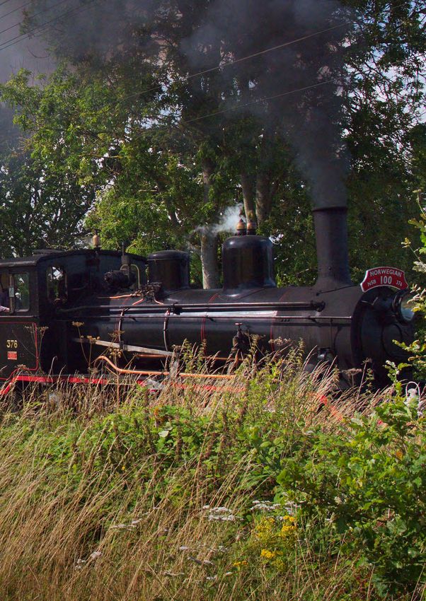
The Railway 47. Shoreham Railway Tunnel
44. Colonel Stephens Greenway St. Michael’s brick-built railway tunnel runs for 31 yards
beneath the highest point of Shoreham Lane on the
The K&ESR railway was extended to run from Tenterden route from St Michaels Halt to High Halden Road. It
to Headcorn is 1905 and was closed in 1954. Part of the operated from 1905 to 1954, and is one of the Tenterden
disassembled railway line was opened as Colonel Stephens to Headcorn line’s main civil engineering features6.
Greenway, running from St Michaels to Turner’s Field.
48. Cranbrook Road Level Crossing and Signal Box
45. Site of St Michaels Halt
The steam railway line crosses the Cranbrook Road
St Michaels Halt was opened in 1912 and comprised through a gated hand operated level crossing with
a single platform made of sleepers and a small, associated signal box. The crossing has white painted
corrugated iron ticket office hut, located south of an wooden crossbar gates.
ungated level crossing over Grange Road. Regular
passenger services from the station were withdrawn
after the last train on Saturday 2nd January 1954, and
the station was then dismantled.
46. Tenterden Town Station and associated buildings
(K&ESR)
Tenterden Town Station comprises platforms and a
collection of railway buildings dating predominantly 3
With thanks to Colin Young for sharing information from his archive,
from the early 20th Century. A number of the buildings Tenterden in World War 2
have been relocated to the station, and some 4
Bloody Hell; Roy Bishop, 2004
are modern but with traditional styling. K&ESR is a 5
Tenterden the First Thousand Years, Hugh Roberts, 1995
significant tourist attraction for the town. 6
Railwaycodes.org.uk Stewart Smith memorial pages
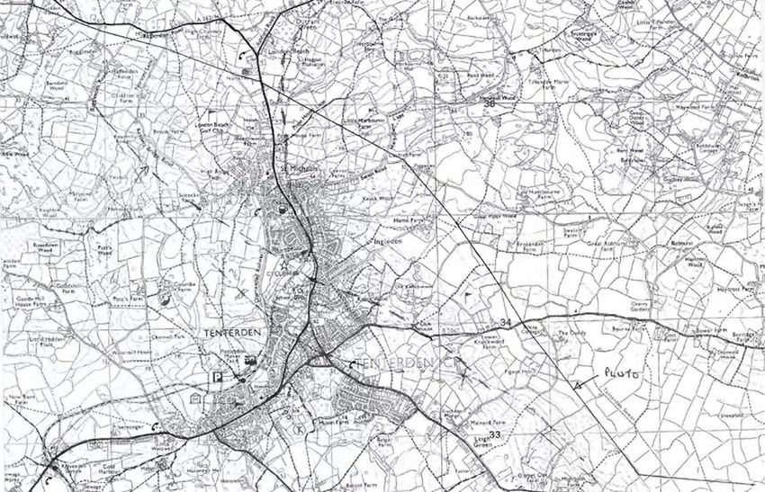
Map showing the route of PLUTO across Tenterden, courtesy of Tenterden Town Museum
Pre-submission Draft June 2021 | Tenterden Neighbourhood Plan 2013 – 2030 83Appendix 3 Associated Projects
Projects Summary In many cases resident groups and associations have,
or will have, an important role to play in delivering
This list summarises current, proposed and potential the projects. These include; resident led steering
projects across the town and parish relating committees and focus groups for TTC projects, new
to the objectives of the neighbourhood plan. Community Interest Companies (CIC), trustee groups,
Some of these come directly out of the work of the Kent Wildlife Trust (KWT), and associations such as the
neighbourhood plan. Tenterden and District Residents Association (TDRA),
the Civil Society etc.
In all cases Tenterden Town Council (TTC) has an
actual or potential role as sponsor, organiser, funder, or Projects relating to land use will in many cases
advocate. In some cases formal responsibility sits with also need to consult with and obtain the support
another authority or delivery agency, for example with of relevant landowners,
either Ashford Borough Council (ABC), or Kent County
Council (KCC). The inclusion of a proposed project on The projects list does not include proposed or planned
this list does not mean the relevant authority or delivery highway works not directly related to the objectives
agency has approved the project to proceed. It is up to of the neighbourhood plan such as one-way systems,
TTC to decide which projects it wishes to progress and traffic lights, or roundabouts, and does not include the
the priorities to be assigned. welcome regeneration of St Mildred’s as TTC has no
formal role in that project.
Project Theme: Social and Cultural Infrastructure, Wellbeing
Project Project Project Delivery Agencies2 Potential
No. Type1 S1063
1. Recreation Ground P TTC, focus group Yes
2. St Michaels Recreation Ground P TTC Yes
3. Encouraging mixed-use community S TTC, ABC Yes
and work spaces (community spaces)
4. Town Hall modernisation P TTC, focus group
5. Cinema project P TTC, Residents Group
6. Football pitches S TTC, Sports Review Yes
7. Markets and Events Management O TTC, CIC
8. Children’s play areas S TTC Yes
9. Outdoor gym areas S TTC Yes
10. Introduce a green plaque scheme S TTC
Project Theme: Biodiversity and Green Objectives
Project Project Project Delivery Agencies Potential
No. Type S106
1. Tenterden Nature Recovery Action Plan S KWT, ABC, TTC, CIC Yes
2. Bio-diversity net gain opportunities S KWT, ABC, TTC
3. Wildlife corridors S KWT, TTC
4. Veteran tree and ancient hedge protection S KWT, ABC, TTC
5. Watercourse and wetland management S KWT, TTC, South East Water, Yes
Environment Agency
6. Orchards and 10,000 Trees campaign S ABC, TTC
7. Wildflower verges P KCC, ABC, TTC
8. Kiln Field P TTC Yes
9. Coombe Lane P TTC, CoE Yes
10. Leisure Centre sustainability review S ABC, TTC, LC Trustees
11. Recycling strategy and hub S ABC, TTC
84 Pre-submission Draft June 2021 | Tenterden Neighbourhood Plan 2013 – 2030Appendix 3 Associated Projects
Project Theme: Routeways and transport
Project Project Project Delivery Agencies Potential
No. Type S106
1. Local Cycling and Walking Infrastructure S KCC, ABC, TTC
Plan (LCWIP)
2. Pedestrian crossings S KCC, TTC Yes
3. Colonel Stephens Greenway upgrade S TTC, ABC Yes
4. Complete Colonel Stephens Greenway S KCC, ABC, TTC, Sustrans
cycle route
5. Improve AB31 and links to AB32, AB30 S KCC, TTC, Sustrans Yes
6. Improve accessibility around S KCC, TTC, Tenterden Yes
Homewood School Schools Trust, Sustrans
7. AB15 upgrade to shared use cycle P KCC, TTC, Sustrans Yes
and walking
8. AB33A upgrade P KCC, TTC, Sustrans Yes
9. AB36 upgrade to shared use cycling P KCC, TTC, Sustrans Yes
and walking
10. AB30 upgrade to shared use cycling S KCC, TTC, Sustrans Yes
and walking
11. Explore rural cycling route connecting S KCC, ABC, TTC Yes
the town centre to N18
12. N18 maintenance and improvement O KCC, TTC
13. Town cycle lane feasibility study R KCC, TTC Yes
14. A19 footbridge replacement S KCC, TTC Yes
15. Replace stiles with kissing gates S KCC, TTC Yes
16. Improve signposts and way markers S KCC, TTC Yes
17. Large scale footpath map O TTC
18. Paved footpaths along roads S KCC, TTC Yes
connecting PROWS
19. Improved cycle storage S TTC Yes
20. Footpath pamphlet P TTC
21. PROW network maintenance S KCC, TTC Yes
Project Theme: Transport Infrastructure
Project Project Project Delivery Agencies Potential
No. Type S106
1. Sustainable Transport Action Plan S KCC, TTC, Civil Society
2. 20 is Plenty campaign and S KCC, TTC, 20 is Plenty
speed-calming measures
3. Air quality surveys P ABC, TTC
4. Move bus idling out of the town centre R Bus Companies, KCC, TTC
5. EV Charging points R KCC, ABC, TTC
6. Improve flood management at S KCC, Environment Agency,
high-risk locations South East Water, TTC
1
Adopt a strategy/plan (S); Research/Feasibility (R); Physical project (P); or other projects (O).
2
Potential/actual lead authority marked in bold
3
The project either has, may, or may potentially receive funding through S106 payments. Other funding sources may also be available.
Pre-submission Draft June 2021 | Tenterden Neighbourhood Plan 2013 – 2030 85Appendix 3 Associated Projects
Project Theme: Supporting the Town Centre & Public Realm
Project Project Project Delivery Agencies Potential
No. Type S106
1. Conservation Area Appraisal and S ABC, TTC
Management Plan (CAMP)
2. Improve street furniture and signposting S TTC Yes
3. Town centre tree planting S ABC, TTC Yes
4. Undertake place-making projects; creating S KCC, ABC, TTC Yes?
destination areas
5. Public toilet improvements P TTC Yes
6. Visitor Brand Review R TTC
7. Destination Plan S TTC
8. Tourism and Visitor Information Centre P TTC
Town and Parish Projects Neighbourhood Projects
This list of current and proposed actions has been Proposals for new and improved community and social
pulled together to articulate the aspirations of infrastructure, including the projects listed below, will
residents, help implement policies, and meet the be supported subject to meeting the objectives of the
aims of and objectives of the neighbourhood plan neighbourhood plan and being compatible with other
using available funding. planning policies in the plan.
Tenterden is going through a period of significant
change, with growth in the number of residents, the Project Descriptions
challenge of maintaining the vitality of the High Street,
and the opportunity to deliver on the vision statement The projects summary list gives a short description
of the neighbourhood plan which sets out the desire of projects grouped by themes. The projects are in no
of residents for a vibrant, welcoming, and inclusive particular order, vary from inception and early-stage
town that is intrinsically connected to its history planning to established projects with clear deliverables
and in harmony with the beauty of the surrounding and timeframes, and require contributions
countryside. Tenterden’s future is rooted in plans for a towards funding or complete funding to be
sustainable and thriving community that offers physical developed and implemented.
and cultural wellbeing to residents and a compelling
offer to visitors and overnight tourists.
This vision will only be achieved with the right level
of strategic planning and investment in community
and social infrastructure. Current and future
infrastructure needs must be evaluated and
addressed in all future development.
These projects have either been identified through
the neighbourhood plan process or are linked to the
neighbourhood plan vision. Some of them are already
underway, others have completed initial planning
but have not yet been implemented, and in other
cases this list is a starting point for these projects to be
developed further. Some projects will require further
feasibility studies to establish how they can be funded
and delivered, in many cases outside the scope of the
neighbourhood plan.
86 Pre-submission Draft June 2021 | Tenterden Neighbourhood Plan 2013 – 2030Appendix 3 Associated Projects
Further details of the projects are set out below: 6. Develop plans to reinstate and plant new traditional
orchards as well as a “Plant 10,000 Trees” campaign
Social and Cultural Infrastructure, Wellbeing to plant native fertile trees across the parish.
7. Extend the current wildflower planting scheme on
1. Complete the redevelopment of the Tenterden verges and public areas, working with the Tenterden
Recreation Ground. Town Council maintenance team.
2. Assess and implement improvements required to 8. Continue to develop the nature reserve at
the St Michael’s Recreation Ground. Kiln Field providing an improved wildlife habitat
3. Identify opportunities to design and create and a sustainable and accessible resource for
new and diverse mixed-use community and the community.
work spaces throughout the parish for people 9. Restore and improve the cemetery in Coombe Lane
of all ages and abilities. as a public amenity space.
4. Modernise and improve the Town Hall providing a 10. Provide solar panels on the Leisure Centre and
sustainable social, cultural and arts anchor building other public and community buildings as part
in the centre of the town. of a strategy to increase sustainable power and
5. Support the Cinema project group in identifying renewable energy generation.
and assessing opportunities to establish a new 11. Develop and implement a town-wide recycling
cinema in Tenterden. strategy including establishing a recycling hub near
6. Identify land suitable for new football pitches the Leisure Centre.
and establish appropriate facilities including pitches
and pavilions. Routeways and Transport; improvements for pedestrians
7. Establish a Tenterden Markets and Events and cyclists
Community Interest Company (CIC) to manage
the overall market and events offering in co- 1. Develop and implement a Local Cycling and
ordination with the Town Manager4. Create a Walking Infrastructure Plan (LCWIP) for Tenterden,
managed calendar of major annual arts and St Michael’s, and Smallhythe in conjunction with TTC
cultural events and festivals that attract significant and Ashford Borough Council (ABC).
numbers of visitors5.
8. Provide further children’s play areas along with 2. Install a controlled crossing near Shoreham Lane
appropriate equipment and upgrade equipment as north of St Michaels connecting routeways either
needed including along Colonel Stephens Way. side of the A28 and allowing improved access for
9. Provide outdoor gym areas including appropriate new development at the Pope House Farm site
equipment including along Colonel Stephens (500m north of the primary school and church
Greenway and the St Michael’s and Tenterden on the east side of the A28). Design and install
Recreation Grounds. new crossing arrangements on the B2067 from
10. Introduce a green plaque scheme for Tenterden Woodchurch Road to Golden Square.
highlighting buildings and places of particular
social and historical interest supported by a self- 4
In recommending the establishment of a CIC, the Local Economy
guided pedestrian tour. Working Group considered that its objectives could include:
a. Creating and managing an overall calendar of market activities that
Improvements to benefit biodiversity attracts residents and visitors to shop and spend time in the town
and that supports local businesses
and green objectives b. Curating market stalls in order to maintain the quality of offer to
shoppers and establish a distinct reputation for Tenterden as a
1. Establish a Tenterden Nature Recovery Community destination for a good local market, excellent farmers market,
and excellent seasonal markets and events celebrating local culture
Interest Company (CIC) to implement the Kent
and produce
Nature Partnership Biodiversity Strategy focused on c. Run a programme to attract and support market stall holders as a
priority habitats and priority species6. low-cost way of establishing local new business and encouraging
2. Establish a framework to identify and record entrepreneurial activity in the town
d. Manage market infrastructure including erecting and maintaining
potential bio-diversity net gain opportunities in the stalls, providing electricity where required, and managing refuse.
parish to provide mitigation for unavoidable loss of e. Support the success of thematic markets and the key
biodiversity resulting from development in the parish annual festivals by working with their management groups
and the town council.
and elsewhere. 5
While recognising other events such as the Spirit of Tenterden take
3. Create and maintain wildlife corridors with species- place, the Local Economy Working Group identified the relevant
rich hedgerows, wildflower meadows, gardens, established key festivals as being:
planters, and verges to encourage pollinating a. Christmas in Tenterden and the Christmas Market
b. The Tenterden Folk Festival
insects and link priority habitat sites. c. The CAMRA Real Ale & Cider Festival (with the opportunity to expand
4. Establish mechanisms to record and safeguard this into the town rather than just at the Station)
notable, ancient, and veteran trees and hedges. It also recommended strengthening the May Fair and create a
stronger connection to its origins in local agriculture and livestock, and
5. Research and monitor the status of local
supporting a new annual summer wine festival celebrating local wine
watercourses, gills, ponds, ditches, marshes and (and brewing) production in the area around Tenterden.
wetlands and undertake action to improve 6
Specifics elements of this include managing improved biodiversity
crossing points, address flooding, mitigate pollution, across the parish, working with stakeholders to support the physical,
mental, and emotional health benefits that engagement with the
and assess opportunities for restoration and natural world provides, and developing and implementing a Tenterden
enhancement, working with Southern Water and the Nature Recovery Action Plan in association with Kent Wildlife Trust’s
Environment Agency. Wilder Towns team.
Pre-submission Draft June 2021 | Tenterden Neighbourhood Plan 2013 – 2030 87Appendix 3 Associated Projects
3. Upgrade Colonel Stephens Greenway: 13. Undertake a feasibility study to create dedicated
a. apply a bound surface and improve lighting to town centre cycle routes.
the 640m southern section of the greenway so it is of
consistent quality along its full length. 14. Install a new raised footbridge on AB19 as it
b. undertake ground works to raise the level of the crosses the stream entering Chennell Park,
path at the low point next to the pond. Clear and including groundworks to dredge the stream and
manage encroaching saplings and undergrowth reduce flooding.
along the entire length of the greenway.
15. Replace stiles with kissing gates at all
4. Complete the Colonel Stephens Greenway cycle locations to improve accessibility throughout
link from St Michael’s to Tenterden High Street along the footpath network.
one of the identified possible routes, including
potentially seeking landowner permission to use the 16. Improve the quality of signs and way markers
edges of Barn Field and Glebe Field. throughout the footpath network, including
directional destination signs from the High Street
5. Appropriately resurface the newly deteriorated to the High Weald Landscape Trail and walking
Six Fields Path AB31 and widen to 3.5m where routes to key attractions such K&ESR,
possible, ensuring quality links to the new housing Chapel Down Vineyard, Ellen Terry’s House,
development and a retained and improved and Biddenden Vineyard.
Three Fields Path AB32. Retain and improve Six Fields
Path AB30. 17. Install a large-scale parish-wide map in the town
centre showing all public rights of way for the
6. Improve footway and public footpath widths to benefit of residents and visitors.
and around Homewood School including across
the shopping parade forecourt and fire station 18. Provide paved footpaths to create safe connections
access road. Seek permission to widen footpath between public rights of way along the following
AB37 to Homewood School by moving the school roads:
boundary fence to allow shared use walking and a. A28 from Castweazle to Rolvenden Station.
cycling. Assess school and neighbouring buildings b. the Cranbrook Road from the cemetery to
pedestrian and vehicle access and design and Chennell Park Road.
install new crossing across the A28. c. the Smallhythe Road connecting AB48 and AB49,
AB35 and AB48, and from the AB53 to Chapel Down
7. Seek permissions to widen Beachy Path AB15 for Vineyard and Smallhythe.
shared use cycling and walking. d. where AB12 crosses the Woodchurch Road.
8. Resurface and light the full length of Sandy Lane 19. Provide good and improved cycle storage facilities
AB33A, removing excess passing bays, installing near Tesco carpark and at the Leisure Centre.
5mph speed signs, and creating formal access
points to the Recreation Ground, building a 20. Provide a pamphlet map showing footpaths in the
causeway through low level marshy areas, parish and describing popular circular walks from
undertaking necessary groundworks by the pond the High Street.
and development site, and providing improved links
to AB30 and AB33. 21. Work with KCC and landowners to improve the
Public Right of Way (PROW) network by removing
9. Remove tubular barriers on AB36 and seek fencing that narrows the footpath to less than
permission to widen the footpath, install a new 2m width including on AB6, AB16, AB34, AB35, AB40,
shared use bridge over the current earth steps and reinstate routes that no longer follow the
and ditch, and investigate shared use cycling and definitive map.
walking to Shrubcote, including removing no cycling
signs along the route. Transport infrastructure
10. Resurface footpath AB30 for shared use cycling and 1. Support the development of a Sustainable Transport
walking and consider appropriate landscaping for Strategy and Action Plan for the parish.
place-making. Seek permission for formal access to
the Waitrose car park and provide a cycle parking 2. Support traffic speed calming measures including
area nearby. a “20 is Plenty” campaign for Tenterden and St
Michael’s, surrounding roads such as Grange
11. Seek landowner and other permissions required to Road, Readers Bridge Road, and Chennell Park
create a shared use walking and cycling network Road, Reading Street, and Smallhythe and provide
connecting to the National Cycle Route 18 (N18) to appropriate speed cameras and vehicle activated
the west of the town. warning signs.
12. Maintain the surface of N18 to an appropriate 3. Conduct regular air quality surveys including at
standard for safe cycling including regular points of high congestion such as Homewood
maintenance and filling in potholes. School and the High Street.
88 Pre-submission Draft June 2021 | Tenterden Neighbourhood Plan 2013 – 2030Appendix 3 Associated Projects
4. Remove arrangements for idling buses from outside
the Vine and along the Greens and relocate the
waiting area to the Cranbrook Road outside the
built confines of the town.
5. Provide increased numbers of Electric Vehicle
(EV) charging points at the Leisure Centre and
other key locations.
6. Working with relevant stakeholders to address
persistent flooding and drainage problems,
including reinstating and clearing blocked ditches,
at several locations including:
a. Appledore Road near Limesland
b. AB40A to Westview
c. Chennell Park Road at the junction with
Cranbrook Road
d. Rolvenden Road near Rolvenden Station
Supporting the Town Centre and Public Realm
1. Develop and implement a Conservation Area
Appraisal and Management Plan (CAMP) covering
the Tenterden and St Michael’s Conservation Areas.
2. Provide appropriate street furniture in the
Conservation Area while reducing street clutter and
introducing more comprehensive signposting of
footpath and cycle routes in the town and to the
surrounding countryside.
3. Plant ornamental, fruit trees, and fertile native tree
species at suitable places around the town.
4. Identify opportunities for improved place-making by
creating destinations for people to assemble, pause,
and meet at key locations in the town including
extended pedestrian areas, and by using improved
seating, planting, and public art.
5. Modernise and improve the public toilets in the
Coombe Lane carpark and on the Recreation
Ground including the provision of high-quality
facilities for people with disabilities.
6. Undertake a review of Tenterden’s brand from the
perspective of residents and visitors.
7. Implement the proposals in the town’s Destination
Plan creating and marketing a distinct view of the
town and what it offers.
8. Establish a new Tourism and
Visitor Information Centre.
Pre-submission Draft June 2021 | Tenterden Neighbourhood Plan 2013 – 2030 89Contact Details: Town Clerk Town Hall 24 High St Tenterden TN30 6AN T 01580 762271 www.tenterdenneighbourhoodplan.org
You can also read