APPENDIX A7 2021 BRIDGE TYPE SELECTION REPORT BNSF/ METROLINK CROSSING
←
→
Page content transcription
If your browser does not render page correctly, please read the page content below
❖ APPENDICES ❖

          APPENDIX A7
2021 BRIDGE TYPE SELECTION REPORT
    BNSF/ METROLINK CROSSING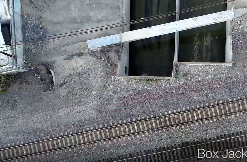
Bridge Type Selection Report (BTSR)
     BNSF / Metrolink Crossing

        OC Loop Segments O, P & Q
          County of Orange, California

                  Prepared for:

                601 N. Ross St.
              Santa Ana, CA 92701

                  Prepared by:

        Contact Person: Bruce Schmith, PE

         Contract No. MA-080-20010599

                August 10, 2021

                GHD | OC Loop OPQ – BNSF Crossing Bridge Type Selection Report | Page i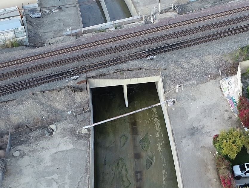
Table of Contents
   1.    Introduction................................................................................................................................... 1
   2.    Existing Conditions ....................................................................................................................... 3

   3.    Design Criteria.............................................................................................................................. 4
   4.    Alternatives Considered ............................................................................................................... 5
   5.    Recommendations ....................................................................................................................... 8

Figure Index
   Figure 1        Vicinity Map ....................................................................................................................... 1
   Figure 2        Project Location Map – OC Loop Segments O, P & Q ..................................................... 2
   Appendix A: Proposed Undercrossing and Overcrossing – Plans & Profiles and Typical Sections

   BNSF/Metrolink Corridor over Coyote Creek (looking upstream from downstream side)

                                                                 GHD | OC Loop OPQ – BNSF Crossing Bridge Type Selection Report | Page ii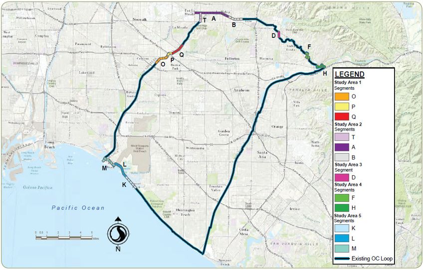
1. Introduction
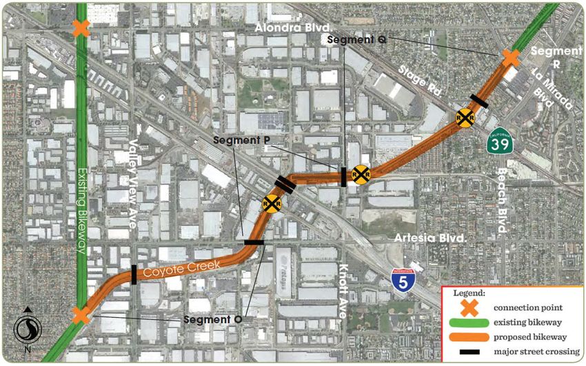
A gap in the 66-mile regional bikeway corridor, the OC Loop, is along the length of the Coyote Creek
flood control channel, upstream and downstream of the Santa Ana Freeway (I-5). This gap is
designated as segments O, P, and Q. The OC Loop Segments OPQ (proposed project) begins at
the existing Coyote Creek Bikeway in the City of Cerritos where the flood channel divides into north
and east forks, running 2.7 miles connecting to another portion of the Coyote Creek Bikeway at La
Mirada Blvd./Malvern Ave. in the cities of Buena Park and La Mirada. The Los Angeles County
Flood Control District (LACFD) owns the majority of the property required for this project. See
Figures 1 and 2 below for Vicinity Map as well as the OC Loop overview & Gap Segment Map.
The project contains three railroad crossing sites, two of which require grade separated crossings
that are key elements to the project and necessary for the bikeway to traverse existing railroad
corridors. The crossing of the BNSF/Metrolink railroad corridor will be addressed in this BTSR.
Figure 1 Vicinity Map
GHD | OC Loop OPQ – BNSF Crossing Bridge Type Selection Report | Page 1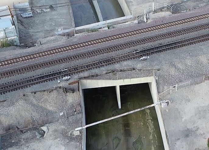
BNSF Crossing

Figure 2   Project Location Map – OC Loop Segments O, P & Q

                             GHD | OC Loop OPQ – BNSF Crossing Bridge Type Selection Report | Page 2
2.   Existing Conditions
     A grade-separated crossing of the BNSF corridor is proposed within Segment Q, just downstream
     from where Coyote Creek passes under Stage Road (see Figure 2). BNSF is the owner of this
     corridor and Metrolink operates their Orange Line and AMTRAK their Pacific Surfliner under an
     operating agreement with BNSF. BNSF freight traffic combined with Metrolink and AMTRAK
     commuter rail traffic makes this the 2nd busiest rail corridor in the nation. There are three tracks at
     this location currently and a 4th track is in the planning & environmental stages. In addition, two
     additional electrified tracks for the LA to
     Anaheim High Speed Rail (HSR) are
     proposed in this corridor. Therefore, any
     overcrossing or undercrossing structure
     needs to stay well outside the existing 100’
     BNSF right-of-way to allow for these
     additional tracks. Downstream from the
     railroad bridge is an abandoned Chevron 8”
     oil line + 2-1/2” gas line crossing over the
     creek and upstream from the bridge AT&T
     has a duct bank in a concrete box girder
     across the creek. These utilities are shown in
     the picture at right and on the cross sections
     below from the original Coyote Creek Channel plans.

     Cross Sections of Chevron and AT&T Utility Corridors (looking downstream)

                                           GHD | OC Loop OPQ – BNSF Crossing Bridge Type Selection Report | Page 3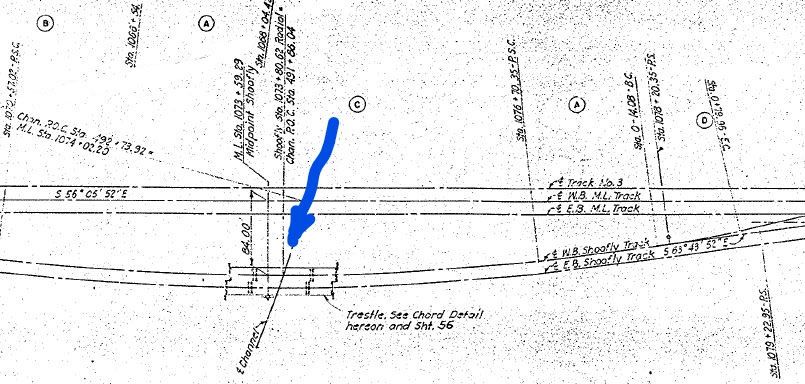
As shown in the picture below and the sections on the previous page, the AT&T duct bank does not
present a conflict with a proposed undercrossing but the Chevron pipeline(s) will most likely be in
direct conflict with a proposed box-jack undercrossing.
In addition to the abandoned Chevron pipeline(s) there are side drains parallel to the railroad and on
either side of the tracks. A 24” RCP side drain exists on the downstream side and a 36” RCP side
drain exists on the upstream side.
Existing 36” Side Drain and AT&T Duct Bank (in concrete box girder)
Upstream side of BNSF/Metrolink Bridge over Coyote Creek
3. Design Criteria
Grade separation design will adhere to the latest edition of the following guidelines:
OC Loop Gap Feasibility Study;
Caltrans Highway Design Manual (HDM), specifically, Chapter 1000
Bicycle Transportation Design;
National Association of City Transportation Officials (NACTO): Urban
Bikeway Design Guide;
American Railway Engineering and Maintenance-of-Way Association
(AREMA) manual; and
GHD | OC Loop OPQ – BNSF Crossing Bridge Type Selection Report | Page 4
Union Pacific Railroad - BNSF Railway Guidelines for Railroad
Grade Separation Projects.
4. Alternatives Considered
Overcrossing and undercrossing options were evaluated at this crossing.
See Appendix A for a plan & profile of each alternative and typical
sections for the undercrossing option.
Overcrossing of BNSF/Metrolink
Appendix A shows the plan & profile for crossing over the entire BNSF right-of-way using a prefab
steel truss bridge, a similar bridge to the one proposed at the crossing of the North Fork of Coyote
Creek, maintaining a minimum required clearance of 23’ - 6”. To meet a maximum grade of 5% on
the upstream side of the crossing, a bridge over Stage Road is also required. Existing power lines in
three locations (downstream from the tracks, just upstream from the tracks and just upstream from
Stage Road) will require relocating to meet minimum clearance requirements. Temporary
Construction Easement (TCE) is required in two locations, downstream from the tracks and
upstream from Stage Road, for purposes of erecting the steel prefab truss sections and for staging
the crane to set the bridges at each location. See the plans for exact locations of these TCEs.
Undercrossing of BNSF/Metrolink
At this crossing, because of the high volume of freight + commuter rail traffic, an “open-cut” option is
not feasible so the only undercrossing option evaluated is a “box-jack” undercrossing under the
width of the entire railroad right-of-way.
Appendix A shows the plan & profile for crossing under the UPRR right-of-way by jacking a 12’ wide
x 10’ high RCB under the railroad corridor using a 5% maximum downgrade and upgrade on either
side of the RCB. This option has the following design features:
Bikeway Profile (Downstream Side) – Approaching from the downstream side, the bikeway
needs to be lowered in a trench. The typical way to construct this trench is to construct a “U-
wall” with concrete walls for the sides and a concrete slab for the floor. Another way, which
may save considerable construction costs, is what is shown in the plan & profile sheet in
Appendix A and the typical section below. Our idea takes advantage of the existing channel
wall to act as one side of the “U-wall” and then laying back the slope at 2:1 on the other side
since sufficient right-of-way exists. Unfortunately, it appears after reviewing the existing
Coyote Creek Channel plans, that the existing channel wall was designed for earth retaining
against it but not when the earth is removed so this wall will need reinforcing for bending in
GHD | OC Loop OPQ – BNSF Crossing Bridge Type Selection Report | Page 5
this direction. Below is a typical section along the downstream approach to the BNSF UC.
Bikeway Profile (Upstream Side) - On the upstream side of the BNSF undercrossing the
profile rises at almost the 5% maximum to meet the existing grade at the top of channel wall
near Sta. 130+00 to be at-grade for the crossing of Stage Road. In this upstream reach the
flood control right-of-way is narrower and laying back the slope at 2:1 is not possible without
going outside the right-of-way. Therefore, a top-down type retaining wall (without tiebacks
or anchors that extend outside the right-of-way) is required along the right-of-way side as
shown below.
GHD | OC Loop OPQ – BNSF Crossing Bridge Type Selection Report | Page 6 12’ x 10’ RCB – The RCB is shown at an elevation designed to meet the 8’ minimum vertical
clearance (from top/box to base/rail), per Section 7.3.2.1 of the UPRR/BNSF Guidelines for
Railroad Grade Separation projects, but still just above the channel invert so stormwater can
be drained, by gravity flow, out of the RCB and into the channel. The length of the RCB
shown extends outside the UBNSF right-of-way on both sides.
RCB Jacking End – A jacking pit at approximately Sta. 127+50 is shown. The jacking pit is
shown on the upstream side of the railroad because equipment and materials required for
construction of the jacking pit, and the jacking equipment and RCB sections, can be easily
transported from Stage Road. The front face of the jacking pit is shown as a temporary
shoring wall, such as a soil mixing wall, a wall strong enough to retain the earth behind the
wall (to support the deep excavation required for the jacking pit) but, at the same time, able
to allow the RCB sections to be jacked through it. Additional discussion regarding the box
jacking process can be found in the “Preliminary Box-Jack Design Report.”
RCB Receiving End – Typically a pit would also be required for the receiving end of the box-
jack but for our construction method (shown in the typical section on the previous page) a
receiving pit is not required as the contractor can construct the bikeway cross section up to
the downstream end of the box culvert. Just as was done for the jacking end, a similar
temporary shoring wall would be constructed along the front face of the receiving pit.
Utility Conflicts – On the downstream side of the crossing, the abandoned Chevron oil
pipeline(s) will most likely be in conflict with the RCB and needs to be “cut, capped &
removed” but the existing 24” RCP side drain can be removed and capped (at the channel
wall) and the tributary it was draining can be graded to drain down to the low point. On the
upstream side of the crossing, the existing 36” RCP storm drain requires rerouting as it is in
direct conflict with the RCB box-jack (see plan & profile sheet in Appendix A). Any shoring
required for excavation and removal of the storm drain that falls within the railroad influence
Zones shown below needs to meet railroad design guidelines for that Zone.
GHD | OC Loop OPQ – BNSF Crossing Bridge Type Selection Report | Page 7 Drainage/Water Quality – A low point in the bikeway profile was created just downstream
from the RCB. This low point can then be drained by a cross culvert under the bikeway that
outfalls into the side of the existing channel wall. On the downstream side of the
undercrossing, stormwater will runoff into the bioswale where it can be treated then routed
to the cross culvert at the low point. On the upstream side of the undercrossing, stormwater
runoff will come from the high point at Stage Road and should either be collected in inlets
(with filters for treatment) that outfall under the bikeway and into the side of the existing
channel or allowed to drain to the low point where a treatment basin could be constructed.
These ideas need to be further explored in the PS&E Phase.
5. Recommendations
An overcrossing of the BNSF/Metrolink corridor is the preferred alternative since an undercrossing is
not financially feasible at this location because BNSF requires a shoofly track(s) be constructed as a
risk mitigation measure.
Other recommendations for this phase of work include:
Potholing the abandoned Chevron pipeline(s) to determine their exact depth for purposes of
verifying a conflict with the proposed box-jack (if an undercrossing option is selected).
Exploratory potholes on the upstream side of the bikeway alignment to determine the
presence of any portion of the buried trestle from the original channel crossing construction
(see below and on next page).
GHD | OC Loop OPQ – BNSF Crossing Bridge Type Selection Report | Page 8GHD | OC Loop OPQ – BNSF Crossing Bridge Type Selection Report | Page 9
Appendix A:
  Overcrossing Plan & Profile
 Undercrossing Plan & Profile
Undercrossing Typical Sections

       GHD | OC Loop OPQ – BNSF Crossing Bridge Type Selection Report | Appendix A
Bruce Schmith, PE, ENV SP Bruce.Schmith@ghd.com 949-585-5274
You can also read


