Application of Terrestrial Laser Scanning Technology for the Purpose of Creating 3D Models of Objects
←
→
Page content transcription
If your browser does not render page correctly, please read the page content below
Application of Terrestrial Laser Scanning Technology for the Purpose of
 Creating 3D Models of Objects

 Tatjana KUZMIĆ, Marko MARKOVIĆ, Mehmed BATILOVIĆ and Vladimir
 BULATOVIĆ, Republic of Serbia

 Key words: terrestrial laser scanning, 3D model, object, point cloud

 SUMMARY

 Modern development, increased capabilities and performance of software and hardware
 products have caused higher standards in many spheres of work and business, including
 construction, design and reconstruction of facilities. Efficient collection of three-dimensional
 data in less time and with less resources has become imperative in maintaining business
 competitiveness. The methodology of terrestrial laser scanning enables the creation of detailed
 3D models of objects and areas of interest over which it is possible to conduct various analyzes,
 calculations and create additional necessary products. The case study in this paper presents a
 scanning of the facade and interior of a seven-storey building (basement, ground floor and 5
 floors) with a TLS (Terrestrial Laser Scanner) and data processing of the realized scanning.
 Scanning using TLS was performed in order to obtain a 3D model of the object for the needs
 of reconstruction, i.e. designing a new state of both the interior and exterior of the building, and
 as a basis for the development of BIM (Building Information Model). The final product of the
 case study analysis will be elaborated complete project implementation methodology that
 covers all phases of the project flow, from the initial one which includes planning of scanning
 using TLS to the final one in which the final results of the applied technology are reached.

Application of Terrestrial Laser Scanning Technology for the Purpose of Creating 3d Models of Objects (11056)
Tatjana Kuzmić, Marko Marković, Mehmed Batilović and Vladimir Bulatović (Serbia)
FIG e-Working Week 2021
Smart Surveyors for Land and Water Management - Challenges in a New Reality
Virtually in the Netherlands, 21–25 June 2021
Application of Terrestrial Laser Scanning Technology for the Purpose of
 Creating 3D Models of Objects

 Tatjana KUZMIĆ, Marko MARKOVIĆ, Mehmed BATILOVIĆ and Vladimir
 BULATOVIĆ, Republic of Serbia

 1. INTRODUCTION

 Laser scanning is one of the modern technologies that are used today in the field of geodesy
 and many other areas for the purpose of obtaining three-dimensional spatial data. TLS can be
 used to obtain three-dimensional (3D) location information for a structural member or an entire
 building without being restricted to a particular location on the structure or affected
 significantly by the environmental conditions [1]. Today, the implementation of construction
 projects with a high level of detail requires up-to-date and high quality spatial data, which meet
 the needs of modern design and monitoring of buildings. The development of hardware and
 software solutions with the use of modern data collection technologies opens the possibility for
 creating quality 3D models of objects that can serve as a basis for creating BIM and monitoring
 the condition of the object, its potential deformations, reconstruction of the object and its
 supervision. Through this concept, data about the object and its parts in the form of a database
 become available at any time.

 BIM is widely seen as a catalyst for innovation and productivity in the construction industry
 [2]. It is an intelligent 3D model-based process that gives architecture, engineering, and
 construction professionals the insight and tools to more efficiently plan, design, construct, and
 manage buildings and infrastructure. Three main BIM benefits are the elimination,
 visualization, and collaboration. First of all, visualization mainly indicates the advantages for
 the improvement and an individual in her/his personal realization as a consequence of utilizing
 the BIM. Second of all, collaboration can be the cooperative behavior of some members in the
 team as the BIM is encouraging and facilitating it. Finally, elimination refers generally project-
 related advantages, for example decreasing the waste, risk, and conflicts [3].

 2. LITERATURE REVIEW

 Many papers deal with usage of laser scanning technology and its implementation for creating
 3D models.

 Comparative analysis of using two laser technology instruments for creating 3D model of
 Cangkuang Temple is given in paper [4]. Instruments used are: Topcon GLS-1000 (Geodetic
 Laser Scanner), which is a robotic long-range scanning instrument, and a Topcon Image Station
 (IS), which is a robotic imaging total station. The 3D distances were calculated for each model.
 Differences in distance were considered as errors in the x, y, and z direction. The 3D surface
 model visualization that was created from the GLS-1000 data was more precise than the one

Application of Terrestrial Laser Scanning Technology for the Purpose of Creating 3d Models of Objects (11056)
Tatjana Kuzmić, Marko Marković, Mehmed Batilović and Vladimir Bulatović (Serbia)
FIG e-Working Week 2021
Smart Surveyors for Land and Water Management - Challenges in a New Reality
Virtually in the Netherlands, 21–25 June 2021
created from the IS data. It is concluded that such 3D surface model visualization could be used
 for documentation, preservation and reconstruction of heritage buildings.

 The case study presented in the paper [5] gives the workflow and methodology for collecting
 and processing data for the purpose of creating a BIM model for data management purposes.
 Complete procedure presented in the paper went through the following stages: establishing the
 external and internal geodetic survey networks, planning and conducting laser scanning of the
 external part of the building, planning and conducting a total station survey of the internal part
 of the building. At the end of each stage, data processing was performed, and finally a BIM
 model was generated. One of the main benefit resulting from creation of a BIM model using a
 point cloud that was concluded in the paper is the ability to detect and define the extent of
 facade damage.

 Aim of study given in paper [6] is to study the limitation uses of TLS and its suitability for
 building survey and mapping. The efficiency of TLS Leica C10 for building survey was
 determined in term of its accuracy and comparing with Zeb-Revo Handheld MLS (Mobile Laser
 Scanning) and the distometer. 3D model of the building for both data, TLS and MLS were
 produced to analyze the visualization for different type of scanners. The RMSE (Root Mean
 Square Error) for TLS technique is 0.001m meanwhile, RMSE for MLS technique is 0.007m.
 The 3D model of building for both models did not have too much difference but the scanned
 data from TLS is much easier to process and generate the 3D model compared to scanned data
 from MLS. It is because the scanned data from TLS comes with an image, while none from
 MLS scanned data. There are limitations of TLS for building survey such as water and glass
 window but this study proved that acquiring data by TLS is better than using MLS.

 Paper [7] gives discussion of the advantages of using TLS in managing existing buildings, from
 various cases of national heritage preservation to clash detection for renovation work. Based
 from the case studies shown, it can be concluded that TLS has helped to shorten the overall
 process of collecting the data representing the scene, due to its ability in generating a high point
 density, rapid acquisition of 3D data and its good accuracy. With the help of suitable software
 available in the market, the process of developing such model to manage existing buildings has
 become easier. However, a number of challenges ahead as the adaptation of the elements of
 BIM, i.e. the 3D models are still deliberated compared to its usage towards pre-constructed
 buildings which has become mature.

 Novel methodology for the accurate and computationally efficient parsing of urban building
 facades from TLS point clouds is presented in paper [8]. The main novelty of the proposed
 methodology is that it is a systematic and hierarchical approach that considers, in an adaptive
 way, the semantic and underlying structures of the urban facades for segmentation and
 subsequent accurate modeling. Performance of the proposed method was evaluated using
 several TLS facade datasets. Qualitative and quantitative performance comparisons with
 several other state-of-the-art methods dealing with the same facade parsing problem have
 demonstrated its superiority in performance and its effectiveness in improving segmentation
 accuracy.

Application of Terrestrial Laser Scanning Technology for the Purpose of Creating 3d Models of Objects (11056)
Tatjana Kuzmić, Marko Marković, Mehmed Batilović and Vladimir Bulatović (Serbia)
FIG e-Working Week 2021
Smart Surveyors for Land and Water Management - Challenges in a New Reality
Virtually in the Netherlands, 21–25 June 2021
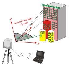
3. TERRESTRIAL LASER SCANNING

 Terrestrial laser scanning enables fast and easy collection of spatial geometric data on buildings,
 machines, objects, etc. With the help of a laser scanner, the area of interest is digitized. The
 oblique length S’ and the two orthogonal angles 1 and 2 are measured up to each point from
 which the laser beam is reflected (Figure 1). Based on these data and the intensity of the
 reflected signal, the position of each point in the 3D local coordinate system is determined. The
 intensity of the reflected wave is important for visualization, especially in complex and dense
 point clouds [9].

 Figure 1. Terrestrial Laser Scanning [9]

 With this technology it is possible to remotely survey very complex, inaccessible and hazardous
 objects and areas, where the traditional methods would fail. Also since the data is largely
 independent of ambient illumination it is even possible to scan at night or in dark conditions.
 The major advantage of this measuring system is the complete and detailed 3D data acquisition
 of objects for many different applications. Specifically, the use of terrestrial laser scanning for
 3D modeling, deformation measurements, monitoring and analysis gives full automation in the
 process, none-contact, higher resolution, efficiency, higher accuracy and precision [10], [11].

 The disadvantage of using TLS is that the scanning process should be done from the location
 as close as possible to the object in order to achieve the highest accuracy and density of points,
 which means that the ground around the object should be stable over time. An ISO standard has
 not yet been defined to further define the procedures for testing TLS, despite the fact that the
 first TLS appeared on the market more than a decade ago [12]. Problems in the implementation
 of this method are the instrument calibration, the need for experts both for the measurement
 process and for the processing and filtering large amounts of data, then the lack of fully
 automated data processing methods. TLS offers wide applications in construction industry and
 maintenance strategies. TLS has also great potential to be utilized for inspection processes due
 to its ability to capture objects in high speed with accuracy up to sub-millimeter and is low cost
 in comparison to other traditional inspection methods [13].

Application of Terrestrial Laser Scanning Technology for the Purpose of Creating 3d Models of Objects (11056)
Tatjana Kuzmić, Marko Marković, Mehmed Batilović and Vladimir Bulatović (Serbia)
FIG e-Working Week 2021
Smart Surveyors for Land and Water Management - Challenges in a New Reality
Virtually in the Netherlands, 21–25 June 2021
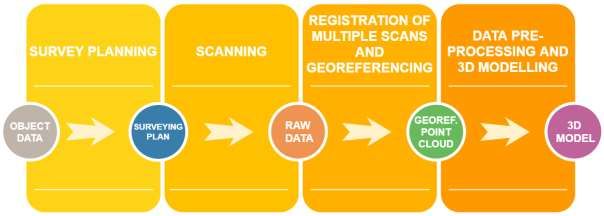
General overview of TLS surveying procedure is given in Figure 2.

 Figure 2. TLS surveying procedure

 Survey planning is still an open question in TLS and no standard rules have been established
 so far. However, it includes [14]:

 ➢ Definition of the area to be surveyed and its preliminary investigation,
 ➢ Definition of the expected resolution and accuracy of the point cloud depending on the
 type of the final deliverables,
 ➢ Selecting the scanner to be used,
 ➢ Optimal locations for the scanning stations should be chosen to guarantee the required
 coverage and accuracy,
 ➢ Choosing types of the targets for the registration and georeferencing, places for their
 location and their geometric configuration.

 Before the scanning starts, the operator sets up the instrument at the defined location, defines
 the 3D section of the scene to be captured and selects the necessary options in the scanning
 software, e.g. sampling resolution, accuracy mode, number of scans, first or last pulse
 measurements etc. After the scanning has started, the operator can follow the process on the
 screen of the laptop computer. When the scanning is complete, the data are saved in a specified
 project file [14].

 Objects being surveyed with a laser scanner are often quite large and complex in shape and
 therefore several scans should be made from different setups of the instrument. Point clouds
 obtained from each setup are referenced to the instrument-fixed, i.e. internal coordinate system
 of the scanner. To obtain a complete representation of the scanned object, the point clouds
 (scans) should be first transformed to a common coordinate system, i.e. the coordinate system
 of a chosen scan. This procedure is called registration, following which the registered scans are
 combined in one dataset. Georeferencing is process of transforming data to desired coordinate
 system, e.g. national coordinate system [14].

Application of Terrestrial Laser Scanning Technology for the Purpose of Creating 3d Models of Objects (11056)
Tatjana Kuzmić, Marko Marković, Mehmed Batilović and Vladimir Bulatović (Serbia)
FIG e-Working Week 2021
Smart Surveyors for Land and Water Management - Challenges in a New Reality
Virtually in the Netherlands, 21–25 June 2021
After the point clouds have been registered and georeferenced, they can be used for modelling.
 The “raw” point clouds cannot be used directly for a specific purpose because they contain
 noise (cars, people passing across the scanning path) that should be eliminated and redundancy
 in the scan overlaps should be reduced. 3D modelling is performed to obtain a 3D model of the
 object surface. Generally, two modelling approaches can be distinguished - Fitting geometric
 primitives and Meshing [14].

 4. SURVEYING OBJECT, METHODOLOGY OF COLLECTING AND
 PROCESSING DATA AND RESULTS

 The building that is presented in the paper and is the subject of the survey is located in the
 vicinity of Frankfurt. The building consists of a basement, ground floor and five floors. The
 Trimble X7 terrestrial laser scanner (Figure 3) was used for scanning each floor separately. The
 specification of this instrument is given in Table 1.

 Figure 3. Trimble X7 [15]

 Table 1. Specification of Trimble X7 [15]
 Range 0,6 - 80 m
 3D Point Accuracy @ 20m 3,5 mm
 Range Accuracy 2 mm
 Angular Accuracy 21’’
 Typical Scan Duration 4 mns
 Imaging 3 x 10 MP.1 mn
 Weight (incl. battery) 5,8 kg
 Calibration Automatic Calibration
 Typical Workflow Full in-field registration
 Field Software Trimble Perspective

 Number of scans collected per each floor is given in Table 2.

 Table 2. Number of scans per each floor

Application of Terrestrial Laser Scanning Technology for the Purpose of Creating 3d Models of Objects (11056)
Tatjana Kuzmić, Marko Marković, Mehmed Batilović and Vladimir Bulatović (Serbia)
FIG e-Working Week 2021
Smart Surveyors for Land and Water Management - Challenges in a New Reality
Virtually in the Netherlands, 21–25 June 2021
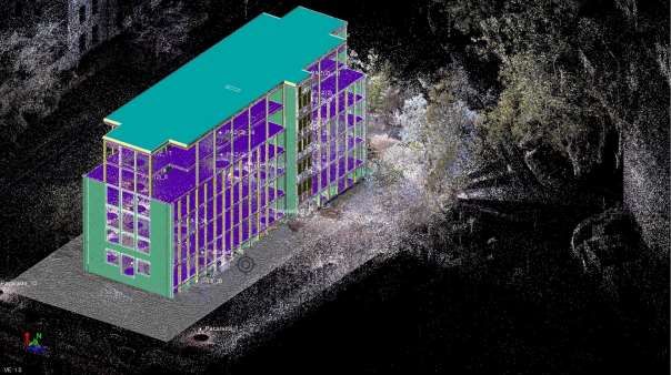
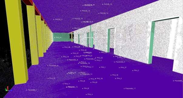
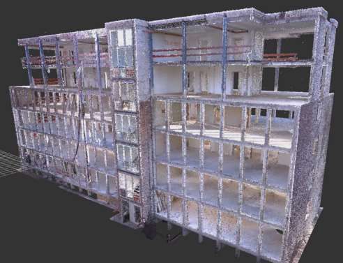
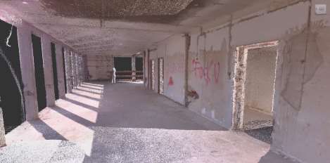
Ground 1st 2nd 3rd 4th 5th
 Facade Basement
 floor floor floor floor floor floor
 16 21 7 15 17 13 10 12

 After collecting data on the field, scans were uploaded in Trimble Business Center software and
 fitted. Figure 4 represents point cloud of whole object.

 a)

 b)
 Figure 4. Point cloud of scanned object – a) part of the object b) whole object

Application of Terrestrial Laser Scanning Technology for the Purpose of Creating 3d Models of Objects (11056)
Tatjana Kuzmić, Marko Marković, Mehmed Batilović and Vladimir Bulatović (Serbia)
FIG e-Working Week 2021
Smart Surveyors for Land and Water Management - Challenges in a New Reality
Virtually in the Netherlands, 21–25 June 2021
Based on obtained point cloud, the digitalization of the facade and all the surveyed floors of
 the building was performed using Revit software (Figure 5).

 a)

 b)
 Figure 5. Digitalized façade and interior of the building – a) part of the object b) whole
 object

Application of Terrestrial Laser Scanning Technology for the Purpose of Creating 3d Models of Objects (11056)
Tatjana Kuzmić, Marko Marković, Mehmed Batilović and Vladimir Bulatović (Serbia)
FIG e-Working Week 2021
Smart Surveyors for Land and Water Management - Challenges in a New Reality
Virtually in the Netherlands, 21–25 June 2021
5. CONCLUSION

 The popularity of Terrestrial Laser Scanners to capture three dimensional objects surrounding
 us is growing and it can be used for various applications. Development in 3D models has also
 led people to visualize the environment in 3D. Visualization of objects in a city environment in
 3D can be useful for many applications such as building restauration, renovation, designing,
 monitoring and planning environment. Precisely for this reason, the importance and
 applicability of 3D modeling of objects in this paper is chosen topic concerning 3D modeling
 of objects based on surveying with a terrestrial laser scanner. The paper presents a way in which
 a 3D model of wide applications can be obtained by scanning an object of interest and
 processing the collected data.

 REFERENCES

 [1] M. Markovic, M. Laban, T. Kuzmic, M. Vujinovic, and S. Draganic, “Application of
 Modern Technologies in Assessing Facade Condition of Building Structures,” in FIG
 Working Week 2020 Smart surveyors for land and water management, no. May 2020.
 [2] N. Bui, C. Merschbrock, and B. E. Munkvold, “A Review of Building Information
 Modelling for Construction in Developing Countries,” Procedia Eng., vol. 164, no.
 1877, pp. 487–494, 2016.
 [3] Saeed Reza Mohandes and H. Omrany, “Building Information Modeling in
 Construction Industry - Review Paper,” Int. Res. J. Eng. Technol., no. 2015, pp. 1324–
 1329, 2016.
 [4] S. Hendriatiningsih, D. Suwardhi, and Januragadi, “3D model based on terrestrial laser
 scanning (TLS) case study: The cangkuang temple, Garut district, West Java,
 Indonesia,” J. Eng. Technol. Sci., vol. 47, no. 1, pp. 1–19, 2015.
 [5] T. Mill, A. Alt, and R. Liias, “Combined 3D building surveying techniques-Terrestrial
 laser scanning (TLS) and total station surveying for BIM data management purposes,”
 J. Civ. Eng. Manag., vol. 19, no. SUPPL.1, pp. 23–32, 2013.
 [6] N. A. S. Russhakim et al., “THE SUITABILITY of TERRESTRIAL LASER
 SCANNING for BUILDING SURVEY and MAPPING APPLICATIONS,” ISPRS
 Ann. Photogramm. Remote Sens. Spat. Inf. Sci., vol. 42, no. 2/W9, pp. 663–670, 2019.
 [7] S. A. A. Shukora, R. Wongb, E. Rushforthc, S. N. Basaha, and A. Zakariaa, “3D
 TERRESTRIAL LASER SCANNER FOR MANAGING EXISTING BUILDING,” J.
 Teknol., vol. 2, pp. 19–25, 2013.
 [8] Z. Li et al., “A hierarchical methodology for urban facade parsing from TLS point
 clouds,” ISPRS J. Photogramm. Remote Sens., vol. 123, pp. 75–93, 2017.
 [9] R. Staiger, “Terrestrial Laser Scanning Technology, Systems and Applications,” Proc.
 2nd FIG Reg. Conf., pp. 1–10, 2003.
 [10] M. Tkáč, P. Mesároš, and T. Mandičák, “Terrestrial laser scanning - Effective
 technology for creating building information models,” Pollack Period. - An Int. J. Eng.
 Inf. Sci., vol. 13, no. 3, pp. 61–72, 2018.
 [11] D. Belton and K. Bae, “Automating Post - Processing of Terres Trial Laser Scanning
 Point Clouds for Road Feat Ure Surveys,” Int. Arch. Photogramm. Remote Sens. Spat.

Application of Terrestrial Laser Scanning Technology for the Purpose of Creating 3d Models of Objects (11056)
Tatjana Kuzmić, Marko Marković, Mehmed Batilović and Vladimir Bulatović (Serbia)
FIG e-Working Week 2021
Smart Surveyors for Land and Water Management - Challenges in a New Reality
Virtually in the Netherlands, 21–25 June 2021
Inf. Sci., vol. XXXVIII, no. 2004, pp. 74–79, 2010.
 [12] C. I. Vintilă, A. C. Rădulescu, and P. I. Dragomir, “Modern Techniques of Lands and
 Constructions Deformation Monitoring,” RevCAD J. Geod. Cadastre, vol. 17, pp. 177–
 184, 2014.
 [13] M. Rashidi, M. Mohammadi, S. S. Kivi, M. M. Abdolvand, L. Truong-Hong, and B.
 Samali, “A decade of modern bridge monitoring using terrestrial laser scanning:
 Review and future directions,” Remote Sens., vol. 12, no. 22, pp. 1–34, 2020.
 [14] Y. Reshetyuk, “Investigation and Calibration of Pulsed Time-of-Flight Terrestrial
 Laser Scanners,” Royal Institute of Technology (KTH), 2006.
 [15] “Trimble Geospatial; DataSheet - Trimble XT 3D Laser Scanning System.” pp. 1–4.

 Note: The paper presents the part of research realized within the project “Multidisciplinary
 theoretical and experimental research in education and science in the fields of civil engineering,
 risk management and fire safety and geodesy” conducted by the Department of Civil
 Engineering and Geodesy, Faculty of Technical Sciences, University of Novi Sad.

 BIOGRAPHICAL NOTES

 Tatjana Kuzmić was born in Zrenjanin, Serbia, in 1992. She received the B.Sc. and M.Sc.
 degrees in geodesy and geomatics from the Faculty of Technical Sciences (FTS), University of
 Novi Sad (UNS), Novi Sad, Serbia in 2015 and 2016, respectively. Currently, she is an Intern
 Researcher at the FTS, UNS. Her areas of interest are GNSS, GIS, 3D terrestrial and airborne
 laser scanning.

 Marko Z. Marković was born in Inđija, Serbia, in 1986. He received the B.Sc. and M.Sc.
 degrees in geodesy and geoinformatics from the Faculty of Civil Engineering, University of
 Belgrade, Belgrade, Serbia in 2008 and 2010, respectively. He received the Ph.D. degree in
 geodesy from the FTS, UNS, Serbia, in 2018. He is currently Assistant Professor at FTS, UNS,
 Serbia. His areas of interest are deformation measurements and deformation analysis of
 building structures, UAV photogrammetry and mapping and engineering geodesy.

 Mehmed Batilović was born in Tutin, Serbia, in 1992. He received the B.Sc. and M.Sc. degrees
 in geodesy and geomatics from the Faculty of Technical Sciences (FTS), University of Novi
 Sad (UNS), Novi Sad, Serbia in 2014 and 2015, respectively. He received the Ph.D. degree in
 geodesy from the FTS, UNS, Serbia, in 2021. Currently, he is a Assistant-Master at the FTS,
 UNS. His areas of interest are deformation measurements and deformation analysis of building
 structures, Earth's crust geodynamic displacement analysis and 3D terrestrial and airborne laser
 scanning.

 Vladimir Bulatović was born in Subotica, Serbia, in 1975. He received the B.Sc. degree in
 geodesy and geoinformatics from the Faculty of Civil Engineering, University of Belgrade,
 Belgrade, Serbia in 2001. He received the M.Sc. and Ph.D. degrees from the Faculty of
 Organisational Sciences, University of Belgrade, Serbia, in 2007 and 2011, respectively. He is

Application of Terrestrial Laser Scanning Technology for the Purpose of Creating 3d Models of Objects (11056)
Tatjana Kuzmić, Marko Marković, Mehmed Batilović and Vladimir Bulatović (Serbia)
FIG e-Working Week 2021
Smart Surveyors for Land and Water Management - Challenges in a New Reality
Virtually in the Netherlands, 21–25 June 2021
currently Associate Professor at FTS, UNS, Serbia. His areas of interest are GNSS, GIS,
 deformation measurements and deformation analysis of building structures, UAV
 photogrammetry and mapping and engineering geodesy.

 CONTACTS

 Intern Researcher Tatjana Kuzmić
 University of Novi Sad, Faculty of Technical Sciences
 Dositej Obradović Square 6
 Novi Sad
 Serbia
 Tel. +381642627287
 Email: tatjana.kuzmic@uns.ac.rs

 Assistant Professor Marko Marković
 University of Novi Sad, Faculty of Technical Sciences
 Dositej Obradović Square 6
 Novi Sad
 Serbia
 Tel. +381656056053
 Email: marko_m@uns.ac.rs

 Teaching Assistant Mehmed Batilović
 University of Novi Sad, Faculty of Technical Sciences
 Dositej Obradović Square 6
 Novi Sad
 Serbia
 Tel. +381694441309
 Email: mehmed@uns.ac.rs

 Associate Professor Vladimir Bulatović
 University of Novi Sad, Faculty of Technical Sciences
 Dositej Obradović Square 6
 Novi Sad
 Serbia
 Tel. +381638435577
 Email: vbulat2003@uns.ac.rs

Application of Terrestrial Laser Scanning Technology for the Purpose of Creating 3d Models of Objects (11056)
Tatjana Kuzmić, Marko Marković, Mehmed Batilović and Vladimir Bulatović (Serbia)
FIG e-Working Week 2021
Smart Surveyors for Land and Water Management - Challenges in a New Reality
Virtually in the Netherlands, 21–25 June 2021
You can also read