April 2021 Tennessee State Climate Summary
←
→
Page content transcription
If your browser does not render page correctly, please read the page content below
April 2021 Tennessee State Climate Summary

         April 2021 Tennessee State Climate Summary
                      Tennessee Climate Office * East Tennessee State University
                         Prepared by William Tollefson and Dr. Andrew Joyner
                  With contributions by Climate Data Representatives across the state
Monthly Temperature Summary:
Monthly mean temperatures were below the 1981-2010 climate normals across most of the state, with a
few locations recording temperatures slightly above normal. The month started out cold, with freezing
temperatures, and even a few snow showers reported on April 1. A widespread frost and freeze event
occurred during the first week of the month, which negatively impacted agricultural and home-garden
interests in the state. Temperatures quickly rebounded in the middle of the month, with most areas of
the state reaching into the 80’s for high temperatures. Then cooler than normal conditions returned for
the latter half of the month with more frost and freeze events around the 15th and 21st. Many weather
stations with long reporting histories set record low daily temperatures on April 22, with temperatures
dropping into the 20’s and 30’s across the state. Then there was one more surge of warm weather in the
last few days of the month. Temperatures across the state ranged from 4°F at Mt LeConte (Sevier County)
on the 3rd to 89°F at Franklin (Williamson County) on the 10th.

                                                                                                     1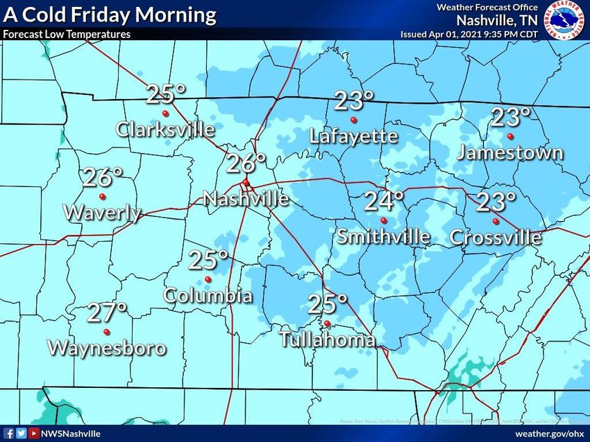
April 2021 Tennessee State Climate Summary

Monthly Precipitation Summary:
After the flooding rains at the end of March, April was much drier across the state. Many areas in East
Tennessee recorded no precipitation during the first week of the month. Otherwise there was widespread
light rainfall during each of the following weeks. However, most locations recorded less than one inch per
week, leading to monthly rainfall totals that were below the 1981-2010 climate normals. Large portions
of East Tennessee and some parts of Middle and West Tennessee recorded less than half their normal
rainfall for the month. The drier than normal conditions were mostly positive, allowing excess water from
the end of March to clear the state. Despite the dry conditions there were no new areas of drought or
abnormally dry conditions introduced in Tennessee on the U.S. Drought Monitor. A few counties in West
Tennessee did record above normal precipitation, mainly due to heavy rains in the first half of the month.

                                                                                                        2
April 2021 Tennessee State Climate Summary

Station Data and Top Tenn. (warmest/wettest, coldest/driest stations of the month):
Station data for airports across the state using WBAN weather stations (Departures based on 1981-2010
climate normals):
                                         Temperatures (˚F)                                 Precipitation (inches)
 Station Name               Averages                           Extremes                              Totals
                 Max      Min     Mean     Depart   High     Date      Low     Date      Obs         Depart   %Norm
   Memphis       71.3    50.6     61.0      -1.9    84       4/12      35      4/21      3.1          -2.4    56%
   Jackson       70.3    45.6     58.0       -2     84       4/9       29       4/3      3.15        -1.71    65%
  Clarksville    68.5    44.8     56.6       -1     84       4/9       27       4/2      2.64        -1.83    59%
   Nashville     70.7    47.4     59.1     +0.1     84       4/27      30       4/2      2.35        -1.65    59%
 Chattanooga     73.7    48.4     61.1     +0.6     86       4/28      31       4/3      1.62        -2.37    41%
   Crossville    64.6    42.1     53.4      -2.4    78       4/27      24       4/2      1.87        -2.95    39%
   Knoxville     69.7    45.9     57.8       -1     83       4/9       27       4/3      2.35        -1.66    59%
   Bristol      68.8 40.3 54.6        -0.6     83     4/27    23     4/3      1.08    -2.25      32%
Departures and %Norm Key: Warmer than Normal, Cooler than Normal; Wetter than Normal, Drier than Normal
                            Hottest Stations (highest maximum temperature)
                                                                               Highest
                                                             Station
                                Station Name                                 Temperature    Date
                                                              Type
                                                                                 (F)
                         FRANKLIN SEWAGE PLANT                COOP               89             10
                                  CELINA                      COOP               87             27
                            TENNESSEE RIDGE                   COOP               87             10
                   MOUSETAIL LANDING STATE PARK               COOP               87             28
                           AMES PLANTATION                    COOP               86             10
                            JACKSON EXP STA                   COOP               86             10
                                GAINESBORO                    COOP               86             12
                          BIG SOUTH TENNESSEE                 RAWS               86             27
                        CAMDEN TOWER TENNESSEE                RAWS               86             9
                         SHILOH NMP TENNESSEE                 RAWS               86             9
                           CHATTANOOGA AP                     WBAN               86             28
                             MEMPHIS WFO                       WBAN             86              10
                            Eight stations tied for the 5th hottest temperature (86°F)

                                                                                                                      3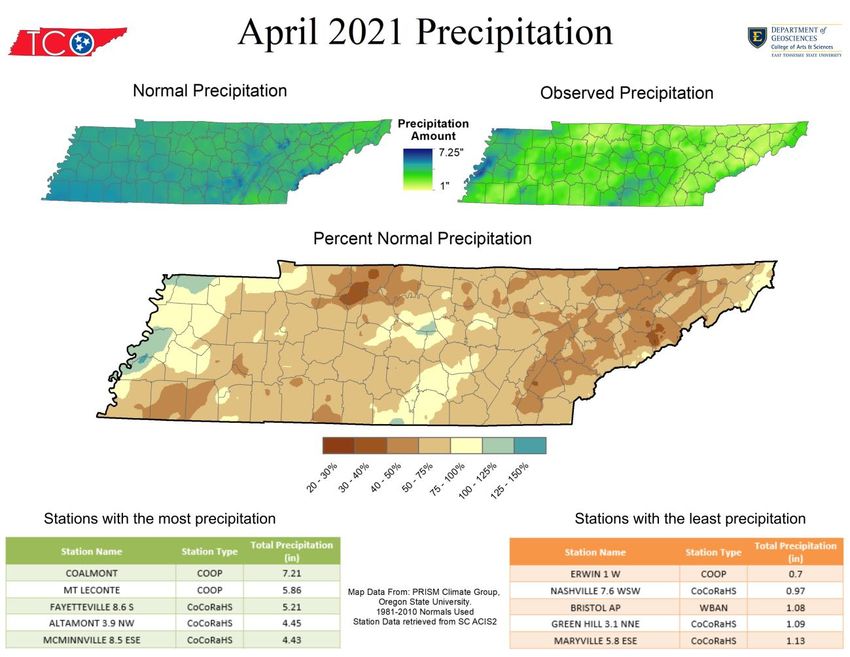
April 2021 Tennessee State Climate Summary

                            Coldest Stations (lowest minimum temperature)
                                                        Station      Lowest
                            Station Name                                              Date
                                                         Type     Temperature (F)
                             MT LECONTE                  COOP           4              3
                          NEWFOUND GAP                  COOP              12           2
                        ROAN MOUNTAIN 3SW               COOP              19           3
                        CHEROKEE TENNESSEE              RAWS              19           2
                              TAZEWELL                  COOP              20           4
                         PICKETT STATE PARK             COOP              20           3
                      INDIAN GRAVE TENNESSEE            RAWS              20           2
                            GAINESBORO                  COOP              21           5
                         CLARKSVILLE WWTP               COOP              21          21
                               ONEIDA                   COOP              22           3
                            BETHPAGE 1 S                COOP              22           2
                             COALMONT                   COOP              22           3
                  CROSSVILLE AREA OFFICE TENNESS         RAWS            22            3
                           Four stations tied for 10th coldest temperature (22°F).

                            Warmest Stations (highest mean temperatures)
                                                                        Mean Temperature
                            Station Name               Station Type
                                                                               (F)
                          CHATTANOOGA AP                   WBAN               61.1
                     MEMPHIS INTERNATIONAL AP              WBAN                61.0
                       SHILOH NMP TENNESSEE                RAWS                60.7
                         GERMANTOWN 4SE                    COOP                59.9
                            BROWNSVILLE                    COOP                59.4
                    LEWISBURG TOWER TENNESSEE              RAWS                59.4
                     CAMDEN TOWER TENNESSEE                RAWS                59.3
                         DYERSBURG III GOLF                WBAN                59.2
                         CLARKSVILLE WWTP                  COOP                59.1
                          NASHVILLE INTL AP                WBAN                59.1

                                                                                             4
April 2021 Tennessee State Climate Summary

                             Coolest Stations (lowest mean temperatures)
                                                                     Mean Temperature
                            Station Name             Station Type
                                                                            (F)
                             MT LECONTE                  COOP              37.4
                           NEWFOUND GAP                  COOP              45.2
                        ROAN MOUNTAIN 3SW                COOP              48.5
                              TAZEWELL                   COOP              50.1
                      PORTLAND SEWAGE PLANT              COOP              50.8
                              ERWIN 1 W                  COOP              51.3
                               ONEIDA                    COOP              51.3
                         PICKETT STATE PARK              COOP              51.6
                           CROSSVILLE 7 NW              WBAN               51.6
                             COALMONT                    COOP              51.9

                             Wettest Stations (highest precipitation totals):
                                                                     Total Precipitation
                             Station Name             Station Type
                                                                             (in)
                              COALMONT                    COOP              7.21
                             MT LECONTE                   COOP                 5.86
                          FAYETTEVILLE 8.6 S           CoCoRaHS                5.21
                          ALTAMONT 3.9 NW              CoCoRaHS                4.45
                         MCMINNVILLE 8.5 ESE           CoCoRaHS                4.43
                              LYNCHBURG                   COOP                 4.38
                              DOVER 1 W                   COOP                 4.37
                        MANCHESTER 2.6 WNW             CoCoRaHS                4.36
                          WINCHESTER 3.9 W             CoCoRaHS                4.3
                   UT MARTIN BRANCH EXP STATION           COOP                 4.23

                              Driest Stations (lowest precipitation totals):
                                                                     Total Precipitation
                             Station Name             Station Type
                                                                             (in)
                              ERWIN 1 W                   COOP               0.7
                          NASHVILLE 7.6 WSW            CoCoRaHS                0.97
                              BRISTOL AP                 WBAN                  1.08
                          GREEN HILL 3.1 NNE           CoCoRaHS                1.09
                          MARYVILLE 5.8 ESE            CoCoRaHS                1.13
                            NEWPORT 1 NW                  COOP                 1.14
                            MARYVILLE 4.9 S            CoCoRaHS                1.15
                           OAK GROVE 3.0 E             CoCoRaHS                1.21
                             KNOXVILLE AP                WBAN                  1.23
                          NASHVILLE 4.1 SSW            CoCoRaHS                1.25

                                                                                           5
April 2021 Tennessee State Climate Summary

                           Snowiest Stations (highest snowfall accumulations):
                              Station Name                Station Type    Total Snowfall (in)
                               MT LECONTE                      COOP               0.2
                   An additional 27 stations in parts of Middle and East Tennessee reported a
                                      trace of snow (less than 0.1”) in April.

The Month in Comparison:
Comparing the mean temperature and total precipitation for April 2021 to the past thirty years of data
for April at automated airport weather stations also shows the cool and dry trend for this year. Notably
this was the driest April in the last thirty years in Knoxville, and second driest in the Tri-Cities. However,
looking at the longer station histories for those two locations, this April did not rank in the top-10 driest
Aprils. Also of note, the Nashville and Chattanooga airports recorded mean temperatures slightly above
the 1981-2010 climate normal conditions; however, compared to the past thirty years of data this month
was slightly below the average. The new 30-year climate normals (1991-2020) released by NOAA on May
4 also show this shift, which put April 2021 slightly below the new normal mean temperature for both
cities.

                                                                                                            6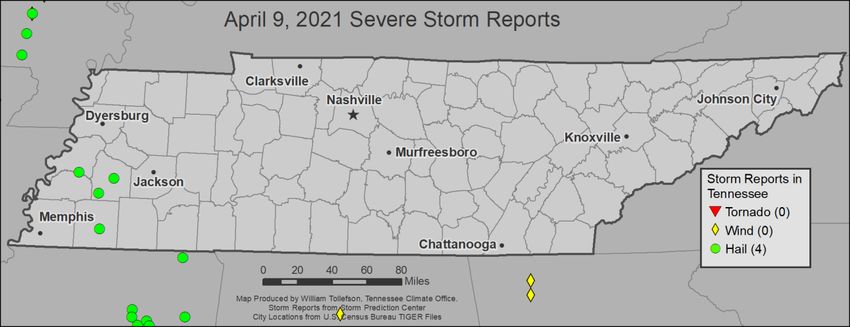
April 2021 Tennessee State Climate Summary

                                             7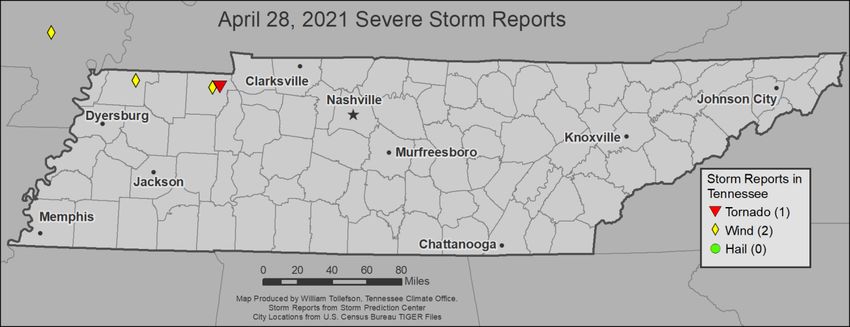
April 2021 Tennessee State Climate Summary

                                             8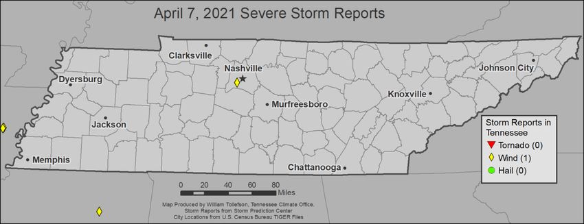
April 2021 Tennessee State Climate Summary

Drought Monitor:
Despite the drier than normal conditions in April across the state, there were no areas of drought or
Abnormally Dry (D0) conditions reported in Tennessee during the month.

                                                                                                        9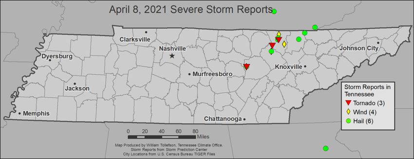
April 2021 Tennessee State Climate Summary

Soil Moisture:
Calculated soil moisture exceeded 600mm across the state, which was normal or slightly above normal.
Heavy rains at the end of March and below normal rain in April, produced a drying trend in soil moisture
levels, with many areas in Middle and East Tennessee dropping by 40mm. The USDA weekly crop weather
report issued for the week ending May 2, listed topsoil moisture as 6% short, 71% adequate, and 23%
surplus, and subsoil moisture as 6% short, 74% adequate, and 20% surplus.

                                                                                                     10
April 2021 Tennessee State Climate Summary
11April 2021 Tennessee State Climate Summary
Streamflow:
A few stream gauges, mostly around Nashville and Memphis, reported below normal streamflows for the
month of April. Most stream gauges across the state reported streamflow in the normal range for the
month but a few, mostly in southern sections of Middle and West Tennessee, reported above normal
streamflow for the month.
12April 2021 Tennessee State Climate Summary
Miscellaneous:
Crop Conditions from USDA: Flooding rains at the end of March led to a delay in planting in many areas
of the state at the beginning of April. This was followed by a widespread freeze, which occurred during
the first week of April. This freeze led to commercial crop and garden losses. Twenty-five percent of
tomatoes, beans, and other commercial crops that had been set were lost due to the cold weather in East
Tennessee. Additional frost/freeze events occurred in the middle of the month for portions of East
Tennessee and the Cumberland Plateau. Due to the multiple frost/freeze events, fruit and vegetable yields
are expected to be greatly diminished in that region. Corn and Soybean planting continued this month,
and cotton planting started in West Tennessee by the end of the month. Winter wheat conditions were
mostly good, with most of the crop jointed, but running a bit behind average for the headed stage.
Fire Danger: The Interagency Fire Center outlook for May shows normal potential for significant wildland
fires across Tennessee, as well as the entire eastern US.
13April 2021 Tennessee State Climate Summary
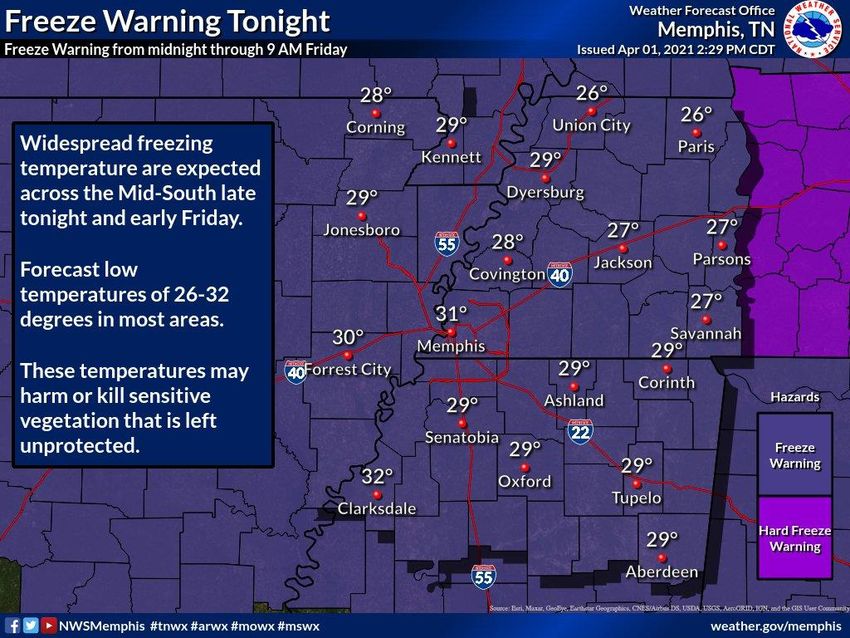
Snow: The reports of snowfall on April 1 were not an April Fools joke. A strong cold front swept the state,
bringing freezing temperatures and precipitation to Middle and East Tennessee. Mt LeConte in the Great
Smoky Mountains National Park was the only weather station that reported measurable snowfall, but 27
other weather stations in Middle and East Tennessee reported a trace of snow (less than 0.1”), including
the Nashville and Tri-Cities airports. Some locations in the higher elevations in the Plateau and East TN
mountains also reported some snowfall on April 21.
Story of the Month:
The major stories of April 2021 were the frost/freeze events during the month which negatively impacted
agricultural producers and home gardeners across the state. The first and most widespread freeze event
occurred in the first few days of the month, with two or three nights of freezing temperatures reported
at many locations. While still within the average last freeze/frost date for most locations across the state,
this event did damage some crops/gardens as many plants were already blooming or growing by this time.
Morning lows on April 2 tied a record low at the Tri-Cities airport, was the 3rd coldest daily low at Nashville
and Knoxville, and tied for 5th coldest at Memphis.
14April 2021 Tennessee State Climate Summary
Later in the month another cold front brought frost and freeze conditions again April 15-16, which was
right on time for the average last freeze for many locations in Middle Tennessee and lower elevations of
East Tennessee. This was followed by another stronger cold spell on April 20-23 with temperatures dipping
into the 20’s and 30’s across the state. On April 21, Memphis set a record daily low temperature (35°F),
then on April 22 Memphis (37°F), Jackson (31°F), Chattanooga (33°F), Knoxville (30°F), and the Tri-Cities
(25°F) all set record daily low temperatures.
15April 2021 Tennessee State Climate Summary
16April 2021 Tennessee State Climate Summary
Storm Reports:
*Storm Reports are based on filtered NOAA Storm Prediction Center data or local NWS storm reports. Future quality
control checks may change the official record of severe events, please see spc.noaa.gov for any updates.
There were five days in April with severe weather reports, resulting in a total of 4 tornadoes, 8 reports of
severe wind damage, and 10 reports of hail 1-inch or larger in diameter.
April 7
Wind:
Time
Speed Location County Lat Lon Comments
(UTC)
2 NW
FENCE BLOWN OVER AND SCOREBOARD
5:20 -- BELLE DAVIDSON 36.12 -86.87
SNAPPED AT HILLWOOD HIGH SCHOOL (OHX)
MEADE
17April 2021 Tennessee State Climate Summary
April 8:
Tornadoes:
Time
Strength Location County Lat Lon Comments
(UTC)
THIS EF-0 TORNADO QUICKLY SPUN UP
NEAR HWY 70 AND BROWNSTOWN RD
PLEASANT THEN MOVED NE INTO PLEASANT HILL
20:15 EF0 CUMBERLAND 35.97 -85.2
HILL WHERE SEVERAL STRUCTURES SUFFERED
ROOF AND SIDING DAMAGE ALONG WITH
BRO (OHX)
911 CENTER REPORTED A BRIEF TORNADO
2W
21:30 -- SCOTT 36.33 -84.65 TOUCHDOWN IN THE NYDECK AREA. NO
ELGIN
REPORTS OF DAMAGE AT THIS TIME. (MRX)
2N HOMES DESTROYED ON NORMA RD AND
22:20 EF2 SCOTT 36.43 -84.51
NORMA STRAIGHT FORK RD. (MRX)
Wind:
Time Speed
Location County Lat Lon Comments
(UTC) (mph)
MULTIPLE TREES DOWN. DAMAGE TO
PLEASANT PLEASANT HILL HIGH SCHOOL AND ADJACENT
20:11 -- CUMBERLAND 35.98 -85.2
HILL NURSING HOME. POSSIBLE TORNADO. TIME
ESTIMATED FROM RADAR. (OHX)
21:30 -- SUNBRIGHT MORGAN 36.24 -84.67 TREES DOWN. POSSIBLE TORNADO. (MRX)
DAMAGE TO STRUCTURES... TREES AND
2N
22:20 -- SCOTT 36.36 -84.39 POWER LINES DOWN NEAR NORMA RD AND
NORMA
BAKER HWY. POSSIBLE TORNADO. (MRX)
2 NNE REPORT FROM MPING: 3-INCH TREE LIMBS
22:53 -- SCOTT 36.53 -84.5
ONEIDA BROKEN; POWER POLES BROKEN. (MRX)
Hail:
Time Size
Location County Lat Lon Comments
(UTC) (in)
PLEASANT
20:11 1.00 CUMBERLAND 35.98 -85.2 (OHX)
HILL
QUARTER TO HALF DOLLAR SIZED HAIL
21:40 1.25 SUNBRIGHT MORGAN 36.24 -84.67
REPORTED. (MRX)
18April 2021 Tennessee State Climate Summary
Time Size
Location County Lat Lon Comments
(UTC) (in)
3 NW
21:45 1.00 SCOTT 36.44 -84.53 (MRX)
HUNTSVILLE
QUARTER SIZED HAIL ALONG HIGHWAY 27.
22:00 1.00 2 S ONEIDA SCOTT 36.47 -84.52
(MRX)
23:15 1.75 1 SW DUFF CAMPBELL 36.44 -84.08 (MRX)
23:35 1.50 CLAIRFIELD CLAIBORNE 36.55 -83.95 (MRX)
April 9:
Hail:
Time Size
Location County Lat Lon Comments
(UTC) (in)
4 SSW
22:30 1.00 TIPTON 35.63 -89.61 (MEG)
HENNING
22:39 1.00 STANTON HAYWOOD 35.46 -89.4 (MEG)
22:42 1.25 WILLISTON FAYETTE 35.16 -89.38 (MEG)
REPORT OF QUARTER SIZED HAIL IN
23:01 1.00 BROWNSVILLE HAYWOOD 35.59 -89.25
DOWNTOWN BROWNSVILLE. (MEG)
19April 2021 Tennessee State Climate Summary
April 24:
Wind:
Time Speed
Location County Lat Lon Comments
(UTC) (mph)
3W POWER LINES DOWN IN THE 3300 BLOCK OF
21:15 -- LAWRENCE 35.32 -87.35
ETHRIDGE BUFFALO ROAD (OHX)
April 28:
Tornado:
Time
Strength Location County Lat Lon Comments
(UTC)
VIDEO EVIDENCE OF A TORNADO NEAR
4 SSE
0:05 -- HENRY 36.38 -88.18 HIGHWAY 79 AND SULPHUR WELLS ACADEMY
BUCHANAN
ROAD. (MEG)
Wind:
Time
Speed Location County Lat Lon Comments
(UTC)
UNION BRANCHES GREATER THAN A FOOT IN DIAMETER
22:20 -- OBION 36.42 -89.05
CITY TORN FROM TREES. (MEG)
5 SSW TREES DOWN AND ROOF DAMAGE TO ONE HOME
0:00 -- HENRY 36.38 -88.25
BUCHANAN ALONG SHADY GROVE ROAD. (MEG)
20April 2021 Tennessee State Climate Summary
CPC Outlooks for the Next Month:
The NOAA Climate Prediction Center Outlooks for May indicate that all of Tennessee will likely observe
above normal temperatures and precipitation for the next month, with a slightly higher confidence in the
above normal precipitation pattern.
21You can also read