ARC WILDLIFE CROSSING SUCCESS STORIES IN THE WESTERN STATES - SPECIAL PUBLICATION
←
→
Page content transcription
If your browser does not render page correctly, please read the page content below
ARC
      SPECIAL PUBLICATION

WILDLIFE CROSSING SUCCESS STORIES
      IN THE WESTERN STATES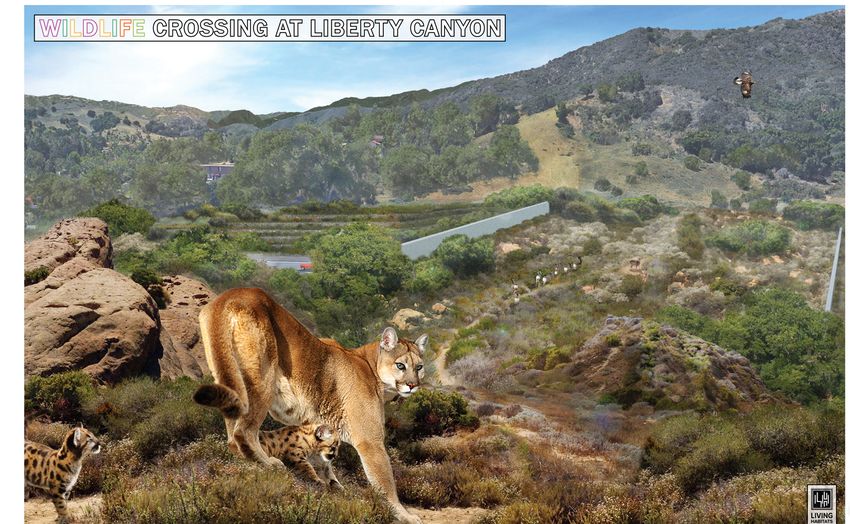
Every 26 seconds – or less – a driver hits an animal, making
                                    TABLE OF CONTENTS                                              highways one of the greatest barriers to wildlife movement in the
pg. 44 - 47                                                                                        United States. In addition to killing 1-2 million large animals every
                                                                                                   year, these collisions cause 200 human fatalities and over 26,000
                                                                                                   injuries, at a cost to Americans of more than $8 billion annually.
                           pg. 40 - 43                                                             Road mortality is also a serious threat to 21 endangered and
                                                                                                   threatened species. The good news is there are proven solutions to
                                                                       pg. 20 - 23
                                                                                                   this problem: Placed in areas of known wildlife movement, wildlife
                                                                                                   crossing structures with associated elements such as fencing, have
                                                                                                   been shown to reduce motorist collisions involving wildlife by up to
                    pg. 32 - 35
                                                                                                   97%.
                                               pg. 16 - 19

                                                                                                   In celebration of how people from all walks of life are working
                                                                           pg. 44 - 47
                                                                                                   together to solve this problem, ARC Solutions has worked with
                                                                                                   its partners and cooperating agencies to compile this series of
                                                                                                   stories to celebrate existing and planned wildlife crossing projects
                                 pg. 28 - 31                                                       aimed at making our highways safer for both people and wildlife.
                                                         pg. 36 - 39
                                                                                                   Although ARC ultimately plans to highlight stories from across
                                                                                     pg. 12 - 15   North America, including all 50 States as well as Canada and
              pg. 8 - 11                                                                           Mexico, this initial version focuses on efforts to protect wildlife
                                                                                                   movement corridors and prevent wildlife-vehicle collisions made
                                                                                                   by 11 Western States, including Arizona, California, Colorado,
                                                                                                   Idaho, Montana, Nevada, New Mexico, Oregon, Utah, Washington,
                                                                                                   and Wyoming.
                                                       pg. 4 - 7
                                                                                 pg. 24 - 27
                                                                                                   We hope you enjoy this showcase of completed and planned
                                                                                                   initiatives featuring a diversity of species, from toads to pronghorn
                                                                                                   to mountain lions; a range of landscapes, from urban to rural
                                                                                                   and in between; and a host of public and private partners, from
                                                                                                   federal, tribal, state and local agencies, to private companies, non-
                                                                                                   governmental organizations, philanthropic foundations and other
                                                                                                   stakeholders.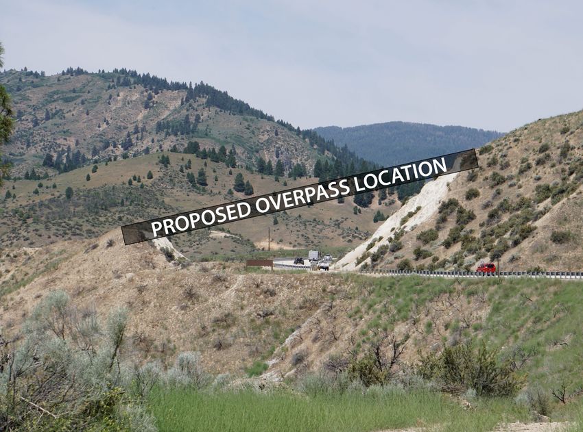
ORACLE ROAD
    CROSSING STRUCTURES
                     Road |        State Route 77 (Oracle Road)
                Structures |       Overpass and Underpass
            Target Species |       Deer

    The Sonoran Desert’s first wildlife overpass and a companion wildlife
    underpass were completed in 2016 along State Route 77/Oracle Road near
    Tucson, Arizona. Built to provide safe passage for mule deer and other
    wildlife across Oracle Road, the project helped reconnect one of Arizona’s
    most vulnerable linkages between the Santa Catalina and the Tortolita
    Mountain ranges, as identified by stakeholders in the 2006 Arizona
    Wildlife Linkage Assessment. As of spring 2020, 26 different species had
    been observed using the crossings for a total of more than 10,000 unique
    wildlife crossings. Annual crossing numbers have increased every year
    since construction was completed, with deer exhibiting a preference for the
    overpass and other species appearing to prefer the underpass. This project
    was made possible by an innovative ½ cent sales tax, approved by Pima
    County voters in 2006, which provided funding to build the two crossings as
    part of a larger planned transportation project that widened the roadway to
    accommodate more traffic. Project partners include: Arizona Department of
    Transportation, Arizona Game and Fish Department, Coalition for Sonoran
    Desert Protection, Pima County Regional Transportation Authority, and Sky
    Island Alliance.

                                                                                  LEARN MORE
                                                                                  Website: Oracle Road Crossing Structures: Frequently Asked Questions
                                                                                  Report: Project Progress Report (2020)
                                                                                  Report: Arizona Wildlife Linkages Assessment (2006)

                                AZ - ARIZONA                                          ORACLE ROAD CROSSING STRUCTURES
4                                                                                                                                                        5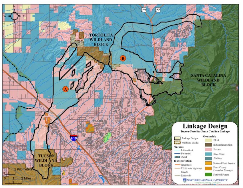
HOOVER DAM
    BIGHORN SHEEP OVERPASSES
                     Road |         U.S. Highway 93
                Structures |        Three Overpasses
            Target Species |        Desert Bighorn Sheep

    In 2011, the Arizona Department of Transportation built three wildlife
    overpasses over U.S. Highway 93 in northwest Arizona to help desert
    bighorn sheep move safely across this busy highway. A primary trade
    corridor connecting Canada, Mexico and the U.S., Hwy 93 has seen a
    steady increase in truck traffic in recent years and is also one of the main
    thoroughfares used by visitors to Las Vegas, Nevada. The network of
    overpasses not only improves driver safety by reducing motorist crashes
    involving wildlife, but also promotes survival of the western U.S.’s largest      LEARN MORE
    population of desert bighorn sheep, native to the Black Mountains. As             Film: AZ Game and Fish Educational Film
    of 2020, the overpasses had been used more than 6,000 times by desert             Report: U.S. Route 93 Long-Term Monitoring
    bighorn sheep and a variety of other species, including bobcat, gray and kit
    fox, deer, and coyote.

    High quality, durable video and photography systems were installed with
    these overpasses, which have aided in monitoring their usage by wildlife. The
    project also involved the successful collaboration of myriad federal, state and
    non-profit partners, including the Arizona Department of Transportation,
    Arizona Game and Fish Department, the Federal Highway Administration,
    National Park Service, Bureau of Land Management, and Arizona Desert
    Bighorn Sheep Society, showcasing the power of the public-private
    partnership in making these projects a reality.

                                  AZ - ARIZONA                                           HOOVER DAM BIGHORN SHEEP OVERPASSES
6                                                                                                                                  7
SIERRA NATIONAL FOREST
    YOSEMITE TOAD CROSSING
                     Road |         Sierra National Forest Road 9S09
                Structures |        Elevated Roadway
            Target Species |        Yosemite Toad

    The Yosemite Toad, endemic to California’s Sierra Nevada Mountains, is
    endangered. These toads can meet their end under the wheels of vehicles
    along stretches of Sierra National Forest roads, which could reduce the         LEARN MORE
    chances of this species’ recovery. The Forest collaborated with the U.S.        Article: Toad Crossing Ahead: New Study Tests Elevated Roads as Underpasses for Rare Toad
    Geological Survey to address this issue by building an elevated roadway         Study: Paving a Path Forward for Reptiles, Amphibians, and Roadways
    on a Forest road section experiencing higher levels of mortality, along
    with fencing to funnel toads towards and under the elevated crossing. The
    elevated roadway effectively creates an “underpass” for toads to cross the
    road, thereby reducing the number of toad mortalities as they move from
    their upland habitat on one side of the roadway, to their wetland breeding
    area, which lies on the other side. While other agencies have built amphibian
    and reptile crossings, those structures are often quite small and narrow.
    By elevating about 100 feet of road, the Yosemite crossing is not only much
    wider but is also permeable to rainfall and light, which gives the toads a
    better chance of successfully making the seasonal trek across the road.

    This project was made possible by a robust partnership including the
    California Department of Transportation, U.S. Geological Survey, U.S.
    Forest Service, and U.S. Fish & Wildlife Service. Toads have already been
    documented using this re-established, risk-free corridor, and researchers
    continue to monitor the project’s effectiveness. Upon completion, the project
    is expected to confirm the utility of using elevated roadway crossings to
    provide safe passage for reptiles and amphibians.

                               CA - CALIFORNIA                                        SIERRA NATIONAL FOREST YOSEMITE TOAD CROSSING
8                                                                                                                                                                          9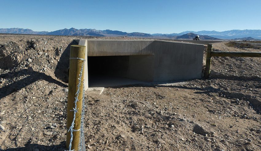
Unlike most other crossing structures, which are funded using public
WILDLIFE CROSSING transportation dollars, the vast majority of the cost for the Liberty Canyon
overpass (an estimated 80%) is being privately funded, with only 20%
AT LIBERTY CANYON coming from public dollars already earmarked for environmental projects.
Road | U.S. Highway 101
To raise awareness about the project, the National Wildlife Federation
Structures | Overpass created the #SaveLACougars campaign, led by Director Beth Pratt, which has
Target Species | Mountain lion, small and large mammals, been a pioneer in engaging the public via social media and other innovative
birds, amphibians and reptiles outreach and funding mechanisms via the project. The overpass would not
be possible without the tireless work of a dedicated group of public-private
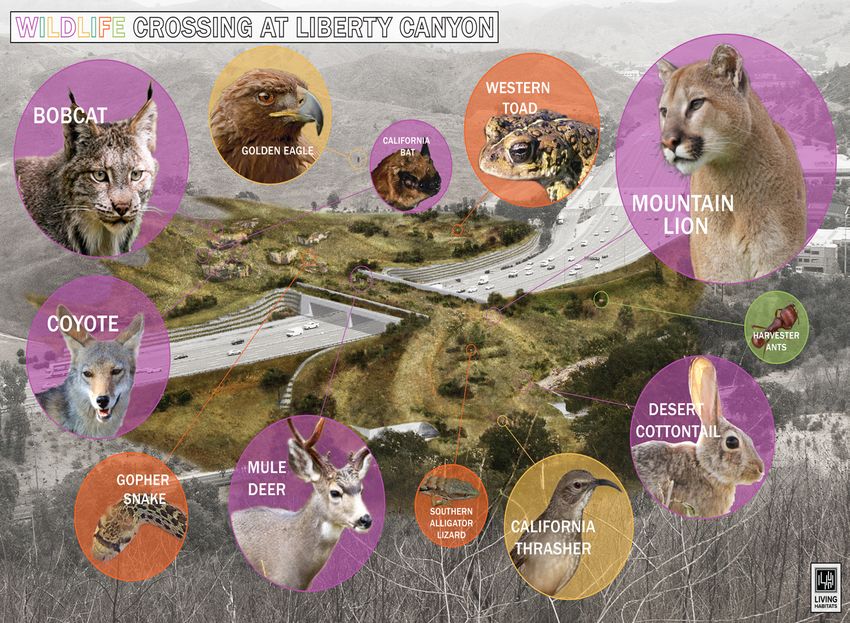
The wildlife crossing at Liberty Canyon, aimed at reconnecting habitat partners, including the National Wildlife Federation, Caltrans, the National
for southern California native wildlife and plant populations, including Park Service, the Santa Monica Mountains Conservatory/ Mountain
mountain lions, will be one of the largest wildlife overpasses in the world Recreation and Conservation Authority, and the Resource Conservation
when completed and is slated to break ground in 2021. The structure, located District of the Santa Monica Mountains. In addition, the partners and the
35 miles north of downtown Los Angeles, will be 165 feet wide by 200 feet Caltrans project team are working with a group of crossing experts from
long and will cross 12 lanes of pavement including ten lanes of US Highway across the world, including Living Habitats, ARC Solutions, the Western
101 and two lanes of a local frontage road. Transportation Institute, the Road Ecology Center at UC Davis, and more.
As human sprawl and roads consume wildlife habitat, many of the
mountain lion populations of southern California are under extreme threat
of extinction. In addition to serving as a lifeline for mountain lions, this
overpass between the Santa Monica Mountains and the Simi Hills will re-
connect the last best linkage from the Pacific Ocean and lands north like
the Sierra Madre Mountains or Los Padres National Forest. As a ‘keystone
species,’ mountain lions serve as an indicator for the overall health of the
natural habitats where they live.
LEARN MORE
Press Release: National Wildlife Federation Unveils New Look at Landmark California
Wildlife Crossing
Article: Califoria Will Build the Largest Wildlife Crossing in the World
Article: This massive wildlife crossing will help protect wildlife from L.A. drivers on the 101
CA - CALIFORNIA LIBERTY CANYON
10 11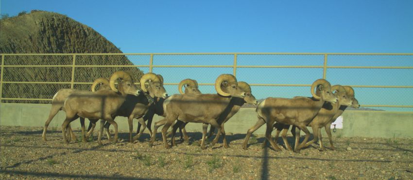
EAST VAIL PASS
     CROSSING STRUCTURE NETWORK
                      Road |         Interstate 70
                 Structures |        Overpass, Underpasses
             Target Species |        Elk, Lynx

                                                                                     Spurred in part by their success mitigating nearby State Highway 9, local
     In Colorado, heavily trafficked Interstate 70, which sees upwards of 22,000     partners formed the Summit County Safe Passages (SCSP) coalition.
     vehicles per day, cuts through the southern Rocky Mountain range. Due           In October 2017, SCSP released a County-Wide Connectivity Plan that
     west of Denver, I-70 bisects important wildlife habitat near Vail Pass, where   identified Vail Pass as one of three priority sites for mitigation. A feasibility
     elk and Canada lynx reside, forcing them to navigate across this stretch        study exploring the construction of three potential crossing structures over
     of highway to access their ever-threatened range. When they try to cross,       the westbound lanes of I-70, including two underpasses and one overpass
     wildlife-vehicle collisions (WVCs) are often the result. In addition to lynx    was completed in fall 2020. When built, these crossings would directly link
     and elk, which are the resident species of highest concern, mule deer, moose,   habitat to the north and south of I-70, thereby allowing populations of elk,
     mountain lion and black bear also frequent the area and would benefit from      lynx, and other wildlife to thrive despite increasing traffic density.
     safe passage across this highway. Currently, five large-span bridges cross
     under the eastbound lanes, and one bridge crosses under the westbound
     lanes; unfortunately, there is no direct connection across both lanes, which                 LEARN MORE
                                                                                                  Website: SCSP Priority Initiative: Vail Pass
     too often leaves animals trying to cross at-grade.                                           Article: Mountain Town News: The Berlin Wall of Wildlife
                                                                                                  Video: I-70 East Vail Pass Wildlife Crossings

                                CO - COLORADO                                                   EAST VAIL PASS CROSSING STRUCTURE NETWORK
12                                                                                                                                                                       13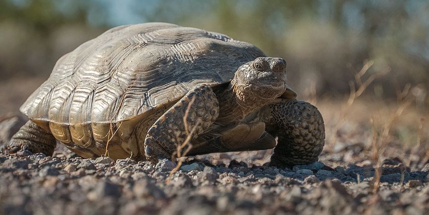
HIGHWAY 9 CROSSING SYSTEM
                      Road |        State Highway 9
                 Structures |       Two Overpasses and Five Underpasses
             Target Species |       Ungulates

     Colorado’s first-of-its-kind network of wildlife crossing structures was
     completed in 2016 as a result of collaborative efforts among the Colorado
     Department of Transportation, Colorado Parks and Wildlife, Blue Valley
     Ranch, Grand and Summit counties, Citizens for a Safe Highway 9 and other
     local stakeholders. The project includes two overpasses and five underpasses
     as well as other infrastructure necessary for wildlife to successfully find
     and navigate the structures. The project’s primary goal is to funnel mule
     deer and other large ungulates such as elk and moose across Highway 9 as
     they move throughout their winter range. Pronghorn, bighorn sheep, black
     bears, mountain lions, bobcats and coyotes have also been documented
     using the structures. In addition to reducing motorist crashes involving
     wildlife by 88%, monitoring efforts have also detected more than 112,000
     successful mule deer movements using these crossings. The project
     involved an innovative state funding program, known as the ‘Responsible
     Acceleration of Maintenance and Partnerships’ or ‘RAMP,’ which allowed         LEARN MORE
     the local community to commit to pay 20% of the project costs in exchange      Website: CO Parks and Wildlife Project Overview
                                                                                    Film: A Safe Passage
     for the project’s timeline being accelerated. Led by a local non-profit        Website: CO DOT Project Overview
     known as Citizens for a Safe Highway 9, with matching funds and in-kind
     contributions from the Blue Valley Ranch, the community raised over $9
     million within 45 days to meet its pledged 20% commitment.

                                CO - COLORADO                                                HIGHWAY 9 CROSSING SYSTEM
14                                                                                                                                    15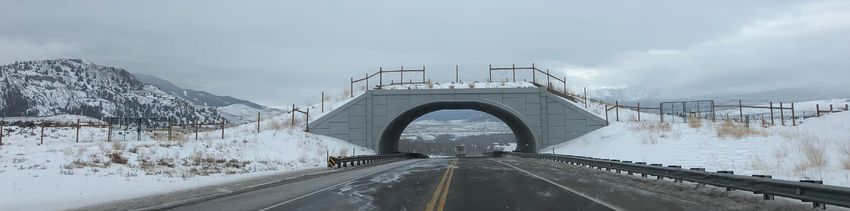
CERVIDAE PEAK OVERPASS
                      Road |         State Highway 21
                 Structures |        Overpass
             Target Species |        Elk, Mule Deer

     Funded by a $3 million Federal Lands Access Program grant, Idaho’s first
     wildlife overpass will be built along State Highway 21, near Mile Post 19.3
     of the Ponderosa Pine Scenic Byway, between Lucky Peak and Idaho City.
     Led by the Western Federal Lands Highway Division of the Federal Highway
     Administration and the Idaho Transportation Department, this project will
     help mule deer and elk migrate between summer range on the Boise and
     Sawtooth National Forests and winter range on IDFG’s Boise River Wildlife
     Management Area, while improving safety for drivers and wildlife. Home to       LEARN MORE
     the largest mule deer herd in the State – upwards of 30,000 individuals– the    Website: Federal Highway Administration: Project Overview
                                                                                     Website: Idaho Transportation Department: ID-21 Cervidae Peak Wildlife Overpass
     area is rich in high-quality habitat that provides important winter range for
     elk and deer, making this a high conflict zone. There is an existing wildlife
     underpass, at Mile Post 18.2, about one mile from the proposed overpass
     site, which will tie into funnel fencing associated with the overpass. By
     guiding animals away from the highway and toward these crossing safety
     structures, the project aims to reduce wildlife-vehicle collisions along this
     stretch of highway by up to 80%. Other project partners include the Idaho
     Department of Fish and Game, the City of Boise, the Boise National Forest,
     and multiple non-profit entities including the Center for Large Landscape
     Conservation, Idaho Deer Alliance, Rocky Mountain Elk Foundation and the
     Yellowstone to Yukon Conservation Initiative. Construction is expected to
     break ground in 2023.

                                    ID - IDAHO                                                         CERVIDAE PEAK OVERPASS
16                                                                                                                                                                     17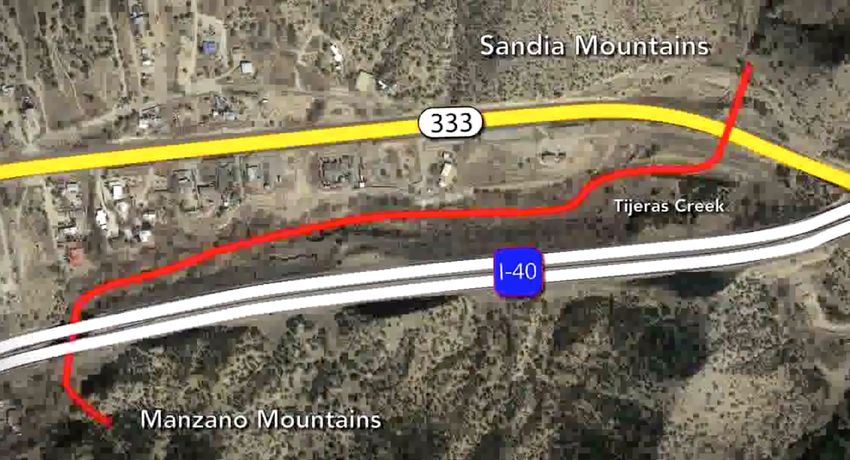
LEMHI RIVER BRIDGES
     REDESIGN PROJECT
                      Road |          State Route 28
                 Structures |         Bridges, Box culvert
             Target Species |         Aquatic and terrestrial species

     Along State Route 28 south of Salmon, Idaho, nine bridges spanning the
     Lemhi River and Agency Creek were reconstructed in 2018 and 2019
     to replace aging structures. The replacements are better equipped to               ITD worked with the Idaho Department of Fish and Game to incorporate
     accommodate a range of aquatic and terrestrial species. These bridges              fishing access locations and install bat habitat (roosting boxes and interstitial
     were part of a larger “17 Bridge” replacement project conducted by Idaho           spacing between the girders) at each bridge. ITD also constructed engineered
     Transportation Department (ITD) that, through a coordinated and                    “log jams” to stabilize river banks instead of rock rip-rap to provide fish
     streamlined design-build and environmental process, were able to save              habitat for listed species like Chinook Salmon, Steelhead and Bull Trout.
     taxpayers millions of dollars while expediting normal project timelines            Species such as Townsend’s big-eared bat as well as a variety of ungulates
     for bridge reconstruction. As a result of the cost savings, ITD was able to        and predators will benefit from the expansion of these bridges along
     conduct a wildlife-vehicle collision study and install three miles of wildlife     waterways.
     fencing to connect two bridges further reducing wildlife-vehicle conflict. All
     nine bridges, which were originally each over 50 years old, were enlarged as       By bundling many bridges into one design-build procurement process,
     part of the project to allow the Lemhi River to span its full width as it passes   the project encouraged innovation, accelerated its timeline, and increased
     underneath, enlarging the waterway and adding room for terrestrial species         efficiency by allowing managers to complete design and environmental
     to travel along the riverbanks.                                                    clearances concurrently for multiple bridges. Ultimately, ITD saved
                                                                                        approximately $6 million in design and construction costs, all while cutting
                                                                                        nearly 20 years off the usual timeline for replacing the bridges. These and
                                                                                        other innovative elements of the project led to its selection for the ITD 2019
                                                                                        Excellence in Transportation award for Environmental Stewardship, the
                                                                                        2018 AASHTO President’s Transportation Award in Planning, and the 2018
                                                                                        ITD Best of the Best award for Innovation.

                                                                                                 LEARN MORE
                                                                                                 Article: “The Transporter” on Environmental Stewardship Award
                                                                                                 Website: Innovate ITD!
                                                                                                 Video: Room to Roam

                                     ID - IDAHO                                                         LEMHI RIVER BRIDGES REDESIGN PROJECT
18                                                                                                                                                                          19
U.S. HIGHWAY 200
Road | U.S. Highway 200
Structures | Two underpasses
Target Species | Elk, Moose, Grizzly Bear
In northwestern Montana near the Scapegoat Wilderness, the Montana
Department of Transportation (MDT) installed two wildlife underpasses as
part of a larger planned highway improvement project along Highway 200
near Lincoln, MT. While the crossings were constructed to reduce the high
number of motorist crashes involving elk and moose, a wide array of species
have taken advantage of the structures to safely pass under the highway.
Grizzly and black bears, elk, moose, wolves, mountain lions, and sandhill
cranes are just some of the species that have been captured on camera
utilizing these underpasses, which helps keep both drivers and animals safer.
Since construction of the crossings, which were sited and built based on
wildlife movement and wildlife-vehicle collision (WVC) data, the number of
WVCs along this stretch of Highway 200 has decreased.
In addition to advancing on-the-ground projects such as that on Highway
200, MDT has also been busy exploring ways to include systematic
consideration of wildlife during its planning and projects. In December 2018,
MDT, the Montana Department of Fish, Wildlife, and Parks (FWP), and
Montanans for Safe Wildlife Passage co-hosted the state’s first Wildlife and
Transportation Summit. That same month, MDT adopted a Wildlife
Accommodations Process aimed at systematic reviews to determine the
need and feasibility of including wildlife accommodations on MDT projects.
In spring 2020, MDT and FWP signed a Memorandum of Agreement
formalizing an agency partnership to work on wildlife and transportation
issues in the state. The success of these underpasses as well as ongoing LEARN MORE
Article: From Bighorn Sheep to Bears to Birds, Cameras Capture Wildlife Using Underpasses
collaborative efforts suggest a bright future for safe passage of people and Website: Montana Wildlife and Transportation
wildlife in the State of Montana! Website: Montanans for Safe Wildlife Passage
MT - MONTANA U.S. HIGHWAY 200
20 21U.S. HIGHWAY 93 NORTH
THE PEOPLE’S WAY
Road | U.S. Highway 93 North
Structures | Overpass, underpasses
Target Species | Grizzly & black bear, elk, mule & white-tailed deer,
other mammals, reptiles and amphibians, fish
The People’s Way Project installed 41 wildlife crossing structures –
including Montana’s first wildlife overpass and dozens of underpasses of
various sizes – along Highway 93 on the Flathead Indian Reservation in
northwest Montana. This highway reconstruction process reflected the
Confederated Salish and Kootenai Tribes connection to the land and the
Montana Department of Transportation’s responsibility to the traveling
public. Negotiations between the Tribes, State and the Federal Highway
Administration resulted in a holistic agreement for the reconstruction The project partners developed one of the most wildlife-sensitive highway
project. designs in all of North America, which won the 2001 AASHTO President’s
Transportation Award for the Environment and the 2008 Federal Highway
“From that process came a radical idea: instead of focusing on how the Administration Transportation Planning Excellence Award. Monitoring
road will impact the land, focus on how the land should shape the road. took place before and after the construction in order to ensure the crossings
The team called this approach a “Spirit of Place.” The Spirit of Place were built in effective locations and to detect the frequency and type of
constitutes more than just the road, it takes into account the surrounding animal use. From 2010-2012, more than 53,000 individual movements were
mountains, plains, hills, forests, valleys, and sky. It includes the paths of recorded by more than 30 unique species, including black and grizzly bear,
waters, glaciers, winds, plants, animals, and native people — the whole mountain lion, bobcat, white-tailed and mule deer, elk, river otter, mallard
continuum of what is seen, touched, felt, and traveled through. The design duck, and turkey.
of the roadway would be premised on the idea that the road is a visitor and
should respond to and respect the Spirit of Place.” (Western Transportation Institute, 2019) As the name suggests, the project was a result of a unique partnership
between tribal, state and federal agencies; enhanced by research through
Montana State University’s Western Transportation Institute and outreach
partnerships with Defenders of Wildlife. Additional research is needed
LEARN MORE to learn more about wildlife tolerance, acceptance and use of highway
Website: US-93 North Post-Construction Wildlife Crossing Structure Monitoring mitigation measures.
Video: Wildlife Using Highway 93 Crossings
Report: Post Construction Monitoring Project Summary
MT - MONTANA U.S. HIGHWAY 93 NORTH THE PEOPLE’S WAY
22 23TIJERAS CANYON
SAFE PASSAGE PROJECT
Road | Interstate 40 and State Highway 333
Structures | Underpasses and warning system
Target Species | Ungulates, carnivores
Just outside Albuquerque, Interstate 40 and State Highway 333 cut through
Tijeras Canyon. This canyon houses Tijeras Creek and serves as a wildlife This project arose from the efforts of Wild Friends, a statewide student group
corridor between the Sandia and Manzano Mountains. Wildlife such as organized through the University of New Mexico School of Law, to work with
deer, black bear, and cougar traverse this canyon as they move between Grades 4 through 12 to draft legislation on issues students find important. In
the mountain ranges, seeking access to water as well as food, shelter, 2003, the classrooms tackled wildlife-vehicle collisions, lobbying the state
and mates. Since 2006, thanks to a public-private partnership including legislature to convene a workshop to investigate the problem. The legislature
the Tijeras Canyon Safe Passage Coalition, New Mexico Department of agreed, and a subsequent analysis identified Tijeras Canyon as a priority
Transportation, and New Mexico Department of Game and Fish, multiple WVC hot-spot that needed to be fixed!
projects in the canyon have led to safer passage for people and wildlife.
This work includes the construction of five miles of wildlife-proof fencing to
funnel wildlife below Interstate 40 via a bridge that spans the Tijeras Arroyo.
About a half-mile away, wildlife are guided to a break in the fencing along
Highway 333 (the old Route 66), where a warning system and electrified
mats are installed. The mats act like electric cattle guards, allowing wildlife
to cross perpendicularly across the highway within the designated crossing
area while preventing them from intruding into the fenced portion of the
roadway. Blinking lights from dusk until dawn warn motorists of potential
wildlife crossings at the crossing area.
LEARN MORE
Video: Making Crossings Safe for Wildlife and People
Article: In New Mexico Canyon, A Novel Way to Prevent Roadkill
NM - NEW MEXICO TIJERAS CANYON SAFE PASSAGE PROJECT
24 25CUBA U.S. HIGHWAY 550 PROJECT
Road | U.S. Highway 550
Structures | Wildlife detection systems and fencing
Target Species | Mule deer and elk
A four-mile stretch of U.S. Highway 550 south of Cuba was identified as
having a high number of wildlife-vehicle collisions (WVCs). In addition
to injuries and property damage, the crashes also resulted in one human
fatality. In 2019, the New Mexico Department of Transportation (NMDOT)
sought to address this WVC hot spot by installing 8-foot high woven wire
fencing to prevent mule deer, elk and other wildlife from entering the
roadway. Two existing bridges within the fenced area provided safe wildlife
passage under the roadway. NMDOT also installed electrified concrete
barriers and animal detection systems (ADS) at both fence ends to address
possible end run events. The electrified concrete barriers prevent mule deer
and elk from getting trapped within the roadway at fence ends. The ADS
are designed to warn motorists of wildlife present at fence ends. The goal of
the project is to enhance safety for the traveling public while also providing
safe wildlife passage. The project was completed in 2019, and NMDOT is
collecting wildlife passage data at both bridges. Preliminary data indicates
mule deer, elk and other wildlife are utilizing the two existing bridges.
Planned future research will evaluate the effectiveness of the ADS in slowing
motorist’s speeds.
NM - NEW MEXICO CUBA U.S. HIGHWAY 550 PROJECT
26 27INTERSTATE 80 AND HIGHWAY 93
PEQUOP CROSSINGS NETWORK
Road | Nevada - Interstate 80 and Highway 93
Structures | Overpasses and Underpasses
Target Species | Mule deer
In rural northeastern Nevada a network of five overpasses and 10
underpasses provide safe passage for mule deer during their annual
migration between their winter range in the Pequop Mountains to their
summer range in the Jarbidge Mountains. The first two overpasses on
Highway 93 were completed in 2010, and 35,000 individual crossings were
recorded within the initial four years after completion. Three additional
overpasses have since been built on Interstate 80, with the final crossings
completed in 2018.
Plan Site Specific
Construction Needs
Completed
Although primarily built for mule deer, many other species including elk,
pronghorn antelope, and red fox, have also used the structures. Nevada’s 2011
decade long effort to improve human safety on US-93 and I-80 is featured
in the documentary film, (Re)Connecting Wild: Restoring Safe Passage. 2016
Selected by over 10 film festivals, the film allows viewers to virtually witness
construction of the wildlife overpasses on I-80 and the restoration of safe
passage for migratory mule deer to more than 1.5 million acres of summer
and winter habitat.
2010
2013
2018
LEARN MORE
Film: (Re)Connecting Wild – Restoring Safe Passage
NV - NEVADA INTERSTATE 80 AND HIGHWAY 93 PEQUOP CROSSINGS NETWORK
28 29MOJAVE DESERT
TORTOISE CROSSINGS
Road | U.S. Highways 93 and 95
Structures | Retrofitted culverts
Target Species | Mojave desert tortoise
In southern Nevada, along U.S. Highways 93 and 95, 20 culverts have
been retrofitted by Nevada Department of Transportation (NDOT) to
improve safe passage by desert tortoises. A threatened species under the
Endangered Species Act, the Mojave desert tortoise is at further risk due to
road mortality, a significant contributor to its declining numbers. Tortoises
began using these culverts, which were originally designed solely to address
water runoff, to move across Highways 93 and 95. As a result, NDOT LEARN MORE
embarked upon an effort to retrofit the structures to better accommodate Report: Development of Dual-Purpose Desert Tortoise Crossing Culverts
Article: How does a desert tortoise cross the highway? It can use a ‘wildlife underpass’
this charismatic, threatened species.
Among other innovations, NDOT has installed fencing to guide tortoises to
the culverts as well as “tortoise-walks” to help them navigate around plunge
pools that form on the downhill side of the culverts. Although these changes
have enhanced safe passage for tortoises, challenges remain. The usage of
riprap or other means of erosion prevention, for example, can make tortoise
passage difficult or in some cases impossible. Failure to control against
erosion, however, leaves the culverts vulnerable to large water events that
are common in the desert; rendering them inaccessible to tortoises. NDOT
is currently working to develop a culvert that can both serve as an easily
navigable tortoise underpass, while at the same time effectively providing
water passage, ideally with little to no maintenance requirements. Although
current retrofitted culverts sometimes provide safe passage for tortoises,
developing a next-generation design for desert tortoise underpasses will be a
big win for the future of the Mojave desert tortoise.
NV - NEVADA MOJAVE DESERT TORTOISE CROSSINGS
30 31U.S. HIGHWAY 20
HARPER TO JUNTURA
Road | U.S. Highway 20
Structures | To be determined
Target Species | Mule deer
U.S. Highway 20 between Harper and Juntura in eastern Oregon bisects one
of the state’s highest density mule deer winter ranges. This area within the
Malheur River watershed has seen a mule deer population decline of 25-
42% over the last four years. In addition to wildfire activity and the spread of A key component of this assessment will be the identification of
invasive plant species, wildlife-vehicle collisions (WVCs) along highway 20 in recommended safe wildlife passage mitigation measures aimed at reducing
the Malheur River Canyon have contributed to the deer’s population decline. WVCs along U.S. 20 between Harper and Juntura. Recommended
In 2019, the Burns Paiute Tribe, which resides in the area and greatly mitigation may include retrofitting of existing culverts and bridges to
values populations of deer, elk, and other species, secured Bureau of Indian better accommodate wildlife as well as proposed new wildlife mitigation
Affairs funding to work with stakeholders to identify measures to improve infrastructure. The Tribe’s assessment and the adoption and implementation
habitat connectivity for mule deer and other species along this stretch of of recommended mitigation measures will be a big win for mule deer and
Highway 20. The Tribe will lead the crafting of a wildlife habitat connectivity other wildlife in this region.
assessment, which will involve working with state and federal agencies, as
well as holding public meetings, to determine how and where wildlife move. Other ongoing conservation efforts in this region include a partnership
project between the Oregon Department of Fish and Wildlife’s (ODFW)
Mule Deer Initiative and the Bureau of Land Management to improve shrub
cover across 750 acres in a nearby fire scar, riparian area restoration by the
LEARN MORE Burns Paiute Tribe, and monitoring of mule deer GPS collar data by ODFW
Article: Guest Blog by Calla R. Hagle, Natural Resources Director for the Burns Paiute and the Tribe. In combination with construction of recommended wildlife
Tribe, “How to Address a Wildlife-Vehicle Collision Hot Spot” infrastructure, these ongoing efforts should reduce WVCs and improve
Report: Oregon 2020 Action Plan for SO3362
habitat connectivity, enabling deer and other species to thrive long into the
future.
OR - OREGON U.S. HIGHWAY 20 HARPER TO JUNTURA
32 33U.S. HIGHWAY 97 UNDERPASS
Road | U.S. Highway 97 ODOT is currently moving forward with plans for a second wildlife
Structures | Underpass underpass along US-97 near Gilchrist, as part of the next phase of the
twinning project. Over 250 crashes involving deer and elk were reported
Target Species | Mule deer
between 2010 and 2017 along the targeted 10-mile stretch. A public-private
partnership has raised more than $500,000 in funding for the project,
including $240,000 from the Oregon Department of Fish and Wildlife
(ODFW); $110,000 from the Oregon Hunters Association; $75,000 from the
Oregon Wildlife Foundation; and $20,000 from the Mule Deer Foundation.
In 2012, the Oregon Department of Transportation (ODOT) built a wildlife Statewide, the cost of WVCs is estimated to exceed $44 million, and in June
underpass on Highway 97 just south of Bend, Oregon, near Lava Butte. 2019, Governor Kate Brown signed the bipartisan Oregon Wildlife Corridors
Faced with peak summer traffic volumes of up to 24,000 cars per day, bill into law. Among other things, the new law calls for state agencies to
the crossings were included in a planned project to double, or “twin,” the identify where wildlife corridors cross roadways, and to create a Wildlife
increasingly busy highway’s capacity from 2 to 4 lanes. Highway officials Corridor Action Plan aimed at mitigating key WVC hot spots in the state.
installed the underpass and associated fencing to help ensure safe passage
for thousands of mule deer that cross U.S. 97 in the spring to access their
summer grazing range in the Cascade Mountains west of the highway, and
then back again in the fall to reach their winter range east of the highway.
Since its completion in 2012, wildlife-vehicle collisions (WVCs) have
dropped by more than 90%, a clear win for both people and wildlife. While
the underpass was designed with mule deer in mind, more than 40 species,
including black bear, bobcat, elk and squirrels have been documented using
the underpass since monitoring began in 2013. Like most effective wildlife
crossing infrastructure, there was a significant upfront cost; however, based
on the average cost of a WVC with a deer in Oregon ($6,633 in 2012), the
crossings are expected to pay for themselves within 12 years.
LEARN MORE
Website: Strategy Spotlight: US-97 Wildlife Crossing
Article: Another Wildlife Crossing Planned for Highway 97
OR - OREGON U.S. HIGHWAY 97 UNDERPASS
34 35U.S. HIGHWAY 89
KANAB-PAUNSAUGUNT PROJECT
Following construction, more than 78,000 successful mule deer movements
Road | U.S. Highway 89 were detected within the 12-mile project area. It is notable that acceptance
Structures | Seven underpasses and use of the crossings didn’t happen overnight; rather, they roughly tripled
Target Species | Mule deer over the 5-year monitoring period, increasing from about 8,000 in 2013-14,
to nearly 24,000 in 2017-18. This project was possible due to a successful
public-private partnership involving the Utah Department of Transportation,
Utah Division of Wildlife, Arizona Game & Fish Department, Grand Staircase
In 2013, a network of seven underpasses was completed to funnel the prized Escalante National Monument, Kane County, Mule Deer Foundation, and
Paunsaugunt mule deer herd across U.S. Highway 89 in Southern Utah. This Sportsmen for Fish and Wildlife.
herd of about 5,000 deer travels up to 80 miles each way on their annual
migration, one of the longest migrations in the state. The underpasses,
all located in Grand Staircase Escalante National Monument, keep deer
off this busy highway as they navigate between their winter range on
Arizona’s Kaibab Plateau and their summer range in Southern Utah. Three
underpasses already existed and were retrofitted to better suit wildlife; three
underpasses were new construction; and one bridge was retrofitted. This
network of underpasses, one of the first of its kind in the region, has proven
remarkably successful. Prior to the project, this stretch of highway saw ~130
deer-vehicle collisions per mile per year.
LEARN MORE
Article: Utah wildlife crossing set to save hundreds of migrating deer
Report: Post Construction Monitoring
UT - UTAH U.S. HIGHWAY 89 KANAB-PAUNSAUGUNT PROJECT
36 37PARLEYS SUMMIT OVERPASS
Road | Interstate 80
Structures | Overpass
Target Species | Ungulates
The wildlife overpass at Parleys Summit was completed in late 2018
and is already seeing promising results for people and wildlife. Since its
installation, wildlife camera monitoring data reveal that deer, elk, moose,
cougar, bobcat, bear, and marmots are just a few examples of the species
using the overpass. In the two years prior to its construction, the Utah
Department of Transportation (UDOT) reported that more than 100 animals
were hit and killed by motorists on this stretch of Interstate 80 between Salt
Lake City and Park City. LEARN MORE
Video: Parleys Canyon Wildlife Overpass in 2020
Website: Save People, Save Wildlife
Known to locals as ‘slaughter row,’ the history of high crash rates in the
area ultimately spurred formation of a local non-profit called Save People,
Save Wildlife (SPSW). Devoted to advocating for safety measures along
I-80, SPSW has raised funds to pay for wildlife fencing and other safety
elements associated with the overpass; its volunteers also regularly
engage in community outreach and education about the importance of
improving human-wildlife coexistence. SPSW is also part of a public-private
partnership working together to build the crossing. Public partners include
UDOT, the Utah Division of Wildlife Resources (UDWR), and Summit
County.
Spanning six lanes of traffic, the Parleys Summit wildlife bridge is about 50
feet wide and 320 feet long. Part of a $22 million planned transportation
project that included the addition of a climbing lane for trucks, the $5
million overpass was supported by a federal grant for wildlife mitigation.
UT - UTAH PARLEYS SUMMIT OVERPASS
38 39I-90 AT SNOQUALMIE PASS
Road | Interstate 90
Structures | Overpasses and underpasses
Target Species | Ungulates, carnivores, small mammals,
reptiles, amphibians and fish
When the need arose to widen and improve 15 miles of Interstate 90 near
Snoqualmie Pass, a diverse group of public and private partners came
together to provide safe passage for the area’s diverse array of wildlife in the
face of encroaching human development. The longest interstate highway
in the country, I-90 runs east-west from Boston to Seattle and serves as a
critical transportation corridor for freight and people. This 15-mile stretch
of road just outside Seattle, is where I-90 crosses the Cascade Mountain
Range at Snoqualmie Pass, a relatively intact and therefore vital alpine
habitat corridor for animals, most of whom tend to move north-south along These structures are designed to mimic the surrounding ecosystem and
the range. By effectively splitting the Cascades in two, I-90 had constituted include native plant communities that stretch the length of the crossings,
a virtually insurmountable barrier for wildlife movement, until now. The wetlands, and streams, reconnecting previously severed habitat. The
network of more than 27 planned crossing structures includes two large structures will serve as a way for many wildlife species – including but not
overpasses and three large underpasses strictly for terrestrial wildlife that do limited to elk, deer, mountain goat, wolverine, bear, cougar, western toad,
not include water passage, as well as 21 underpasses that include streams. cascade frog, Pacific giant salamander, pika, and river otters – to safely
cross from one side of the highway to the other, with barely a change in
scenery. The monitoring program and I-90 Wildlife Watch has documented
thousands of animals using the completed structures, including a Pacific
giant salamander captured using one of the larger, channelized underpasses
within five days of its completion! As of early 2020, over 7,000 unique
LEARN MORE
Film: Cascade Crossroads crossings had been detected, and those numbers are only expected to rise.
Website: Conservation Northwest’s I-90 Wildlife Corridor Campaign This project has a commitment to long term monitoring in partnership with
News and Updates: WSDOT Facebook Page universities such as Central Washington University to conduct detailed
research on increased connectivity for a variety of species.
WA - WASHINGTON I-90 AT SNOQUALMIE PASS
40 41BUTLER CREEK
Road | U.S. Highway 97
Structures | Underpass
Target Species | Ungulates, carnivores, small mammals,
reptiles, amphibians and fish
In 2012, the Butler Creek Bridge was installed along U.S. Highway 97 north Two-lane highways of medium traffic volume in rural areas, such as this
of Goldendale in southcentral Washington. This project is a great example of one, tend to have relatively high WVC rates. This is likely because traffic
how to improve both fish and wildlife passage as part of a bridge or culvert volume has not yet risen to the level of creating a complete and total barrier
replacement project. Originally 10-feet in diameter, this undersized culvert (deterring wildlife from even attempting to cross); thus, wildlife nonetheless
constricted the channel of the stream it carried, thereby increasing water continue to attempt to cross despite the moderate traffic levels. Wildlife-
velocity, and also had a gradient that was too steep for fish passage. When proof fencing was also installed along each side of the highway in both
it became apparent that fish were not moving through it, the culvert was directions from the bridge to funnel wildlife to the structure. Double-cattle
replaced with a 65-foot span bridge. Because the culvert sat along a stretch guards were installed along side roads to prevent wildlife from entering the
of U.S. 97 that sees very high rates of motorist crashes involving deer, the fenced portion of the main roadway, and wildlife “jump outs” or “escape
bridge not only was designed significantly wider and taller than the original ramps” – that allow wildlife who intrude on the fenced portion of the
culvert, in order to permit the creek to span its full, natural width, but it also highway to “escape” – were also constructed. The mountain lions pictured
allowed enough room to install a pathway underneath the bridge that would above are seen utilizing a jump out. Since the structure’s completion,
encourage terrestrial wildlife to follow that pathway to cross under this busy wildlife-vehicle collisions (WVCs) within a half mile in either direction of
rural highway, rather than crossing at-grade. the structure have dropped by approximately 81%. A wide array of wildlife
have been documented using the structure, including bobcat, the endangered
western gray squirrel, mule deer, snowshoe hare, mountain lion and wild
turkey. This structure improves aquatic habitat and enhances terrestrial
LEARN MORE wildlife passage, greatly reducing WVCs, all at a relatively low cost.
Website: WSDOT - Habitat Connectivity
Website: WSDOT - Improving Wildlife Habitat Connectivity
WA - WASHINGTON BUTLER CREEK
42 43TRAPPER’S POINT
CROSSING COMPLEX
Road | State Highway 191
Structures | Two overpasses, six underpasses
Target Species | Pronghorn antelope and mule deer
The Trapper’s Point Project is located near Pinedale in western Wyoming
along the “Path of the Pronghorn,” a 6,000-year old migration corridor
used by pronghorn antelope. This project includes two wildlife overpasses,
six underpasses and 35 miles of associated wildlife-proof fencing aimed
WYDOT estimates that wildlife-vehicle collisions (WVC) have dropped by
at providing safe passage for pronghorn antelope and mule deer as they
80% for the target species, and that the $9.7 million project will pay for
travel between their winter range in Wyoming’s Red Desert to their summer
itself within 17 years as a result of savings due to fewer wildlife deaths and
range in Grand Teton National Park. The Trapper’s Point Project was
damage to people and property. In addition to its on-the-ground work,
spurred by sustained increased in traffic volumes along this predominantly
WYDOT and WFGD co-hosted the state’s first Wildlife and Roadways
rural roadway, caused in part by the state’s booming natural gas industry.
Summit in April 2017. The Summit inspired formation of the Wyoming
Although mule deer in Wyoming have successfully used wildlife underpasses,
Wildlife and Roadways Initiative, a collaborative effort led by WGFD and
pronghorn in contrast appear to be particularly averse to using concrete
WYDOT to improve public safety, reduce loss of lives and property, and
box underpasses or culverts, which tend to have less natural light. The final
reduce impacts to the state’s treasured wildlife heritage. Wyoming was also
project design thus included a mix of overpasses and underpasses to provide
one of the first states to create a license plate to raise funds to pay for wildlife
both pronghorn and mule deer safe passage, while also allowing other
crossing structures, and in February 2020, Governor Mark Gordon issued an
resident species to safely cross this busy highway. Within the first three years
executive order that sets forth a science-based approach for identifying and
after completion, pronghorn and deer – as well as elk, wolf, bear, and even
conserving potential migratory wildlife corridors within the state.
sage grouse – used the structures to cross the highway more than 60,000
times. This effort was led by Wyoming Department of Transportation
(WYDOT) and Wyoming Game and Fish Department (WGFD), in
collaboration with other agencies and organizations including the Green
River Cattle Association.
LEARN MORE
Images: Trapper’s Point Wildlife Overpass Webcam
Article: Trapper’s Point Engineering Award
Website: Wyoming Wildlife and Roadways Initiative
Website: Governor Gordon signs Wyoming Mule Deer and Antelope Migration Corridor
Protection Executive Order
WY - WYOMING TRAPPER’S POINT CROSSING COMPLEX
44 45TOGWOTEE PASS CROSSING STRUCTURES
Road | U.S. Highway 26
Structures | Underpasses
Target Species | Many native species including ungulates,
carnivores, and fish
A series of wildlife crossing infrastructure was installed along U.S. Highway
26 as it crosses Togwotee Pass, as part of a larger rebuild project for this Native shrubs were planted strategically near the crossings. As they grow
highway. The structures in this corridor include: 2 bridge extensions to in size, this vegetation will not only help provide smaller critters cover, but
accommodate undercrossing, 5 undercrossing box structures for winter will also better direct wildlife towards the crossings. Completed in 2013, the
snowmobile crossings and summer wildlife crossings, 2 fish passage project won a number of transportation planning awards for its innovation,
structures, a buried bridge for wildlife undercrossing, a 50’ radius arch including an America’s Transportation Award for best use of innovation in a
culvert undercrossing, and upsized drainage culverts (also used for small medium-sized project. The project also has been honored by the U.S. Forest
critter crossings) throughout the 38 mile corridor. This stretch of the Service with an award for outstanding partnership to preserve, conserve and
Centennial Scenic Byway, known as “Togwotee Trail,” is flanked by rich enhance the highway corridor’s natural, scenic, visual and wildlife resource
wildlife habitat and serves as a main route to access Grand Teton and values.
Yellowstone National Parks. Because of this highway’s location within the
Greater Yellowstone Ecosystem, one of the last largely-intact ecosystems
in the nation, it is vital that this travel corridor has as little impact on the
natural landscape as possible, hence the inclusion of wildlife underpasses in LEARN MORE
Website: WYDOT Wildlife and Fisheries
the road design. Robust public-private partnership efforts made this project
possible and effective. Wyoming Department of Transportation, U.S. Forest
Service, Wyoming Department of Fish and Game, and multiple conservation
non-profit organizations collaborated to make this project a reality. Each of
the structures is focused on different target species, though all structures see
use by many different species. Grizzly and black bears, wolves, deer, elk and
moose, and river otters and cutthroat trout are a handful of the species that
benefit from these crossing structures. People benefit, too, as driver safety is
improved when animals have their own dedicated tunnels to cross the road,
without having to dodge fast-moving vehicles.
WY - WYOMING TOGWOTEE PASS CROSSING STRUCTURES
46 47This project was made possible by the generous support of the the Yellowstone to Yukon
Conservation Initiative and the New-Land Foundation.
We would also like to acknowledge the contributions of representatives from
transportation and wildlife agencies and organizations that assisted in the review of
STATE PROJECT IMAGE CREDIT case studies, supplied project images, and provided additional resources to support the
AZ Highway 93 ALL IMAGES: Arizona Game and Fish Department
development of the Success Stories.
AERIAL; DEER: Arizona Game and Fish Department
TORTOISE: Jesse Espinosa, Granite Construction
MAP: Arizona Game and Fish Department - Beier, P., E. Garding, and D. Majka. 2006.
AZ Oracle Road
Arizona Missing Linkages: Tucson – Tortolita – Santa Catalina Mountains Linkage STATE PROJECT REVIEWERS
Design. Report to Arizona Game and Fish Department. School of Forestry, Northern
Arizona University AZ Highway 93 Jeff Gagnon, Arizona Game and Fish Department
STRUCTURE; SIGN: Stephanie Barnes, United States Forest Service AZ Oracle Road Jeff Gagnon, Arizona Game and Fish Department
CA Sierra National Forest
TOAD: Cheryl Brehme, United States Geological Survey
CA Sierra National Forest Cheryl Brehme, United States Geological Survey
CA Liberty Canyon ALL IMAGES: Living Habitats LLC/National Wildlife Federation
STRUCTURE: Laramie Maxwell CA Liberty Canyon Beth Pratt, National Wildlife Federation
CO Highway 9
PROJECT MAP & WILDLIFE IMAGES: Colorado Parks and Wildlife Michelle Cowardin, Colorado Parks and Wildlife
LANDSCAPE: Summit County Safe Passages Plan Julia Kintsch, ECO-Resolutions
MAP: East Vail Pass Feasibility Study CO Highway 9
CO I-70 East Vail Pass Tehri Parker, Rocky Mountain Wild
ELK: Mike Mauro, United States Fish and Wildlife Service Paige Singer, Rocky Mountain Wild
LYNX: Steve Torbit, United States Fish and Wildlife Service Michelle Cowardin, Colorado Parks and Wildlife
TOP: Idaho Department of Transportation Julia Kintsch, ECO-Resolutions
ID Cervidae Peak CO I-70 East Vail Pass
BOTTOM: Federal Highway Administration Tehri Parker, Rocky Mountain Wild
STRUCTURE: Idaho Transportation Department Paige Singer, Rocky Mountain Wild
ID Lemhi River
WILDLIFE CAMERA: Idaho Fish & Game Matt Pieron, Idaho of Fish and Game
MT Highway 93 North IMAGE: Montana Department of Transportation ID Cervidae Peak Jake Melder, IdahoTransportation Department
MT Highway 200 ALL IMAGES: Montana Department of Transportation Scott Rudel, IdahoTransportation Department
Jeff Richards, Idaho Fish and Game
STRUCTURE & ANIMAL DETECTION SYSTEM: New Mexico Department of
ID Lemhi River Jake Melder, Idaho Transportation Department
NM Tijeras Canyon Transportation
Scott Rudel, IdahoTransportation Department
MAP: New Mexico Public Broadcasting Service
MT Highway 93 North Whisper Means, Confederated Salish & Kootenai Tribes
NM Highway 550 ALL IMAGES: New Mexico Department of Transportation
Paul Sturm, Montana Department of Transportation
STRUCTURE: NineCaribou Productions, still from (Re)Connecting Wild MT Highway 200
NV Pequop Crossings Bill Semmens, Montana Department of Transportation
MAP: Nevada Department of Transportation
TORTOISE: Stantec NM Tijeras Canyon Mark Watson, New Mexico Department of Game and Fish
NV Mojave Desert
STRUCTURE: United States Fish and Wildlife Service NM Highway 550 James Hirsch, New Mexico Department of Transportation
OR Highway 97 STRUCTURE: Oregon Department of Transportation Nova Simpson, Nevada Department of Transportation
NV Pequop Crossings
OR Highway 20 IMAGE: Burns Paiute Tribe Cody Schroeder, Nevada Department of Wildlife
Kristi Holcomb, Nevada Department of Transportation
UT Parleys Summit STRUCTURE: Utah Department of Transportation NV Mojave Desert
Nova Simpson, Nevada Department of Transportation
STRUCTURE: Chris Detwick OR Highway 97 Cidney Bowman, Oregon Department of Transportation
UT Highway 89
MAP: Utah Department of Transportation Cidney Bowman, Oregon Department of Transportation
WA Butler Creek ALL IMAGES: Washington State Department of Transportation OR Highway 20
Calla Hagle, Burns Paiute Tribe
WA I-90 Snoqualmie Pass STRUCTURE: Washington State Department of Transportation UT Parleys Summit Daniel Olson, Utah Division of Wildlife Resources
WY Trapper’s Point IMAGE: Wildlife Conservation Society UT Highway 89 Daniel Olson, Utah Division of Wildlife Resources
WY Togwotee Pass ALL IMAGES: Wyoming Department of Transportation Scott Downes, Washington Department of Fish and Wildlife
WA Butler Creek Elizabeth Torrey, Washington Department of Fish and Wildlife
Glen Kalisz, Washington State Department of Transportation
Scott Downes, Washington Department of Fish and Wildlife
WA I-90 Snoqualmie Pass
Glen Kalisz, Washington State Department of Transportation
WY Trapper’s Point Darin Martens, U.S. Forest Service / Wyoming Department of Transportation / FHWA
WY Togwotee Pass Darin Martens, U.S. Forest Service / Wyoming Department of Transportation / FHWA
PROJECT IMAGES ACKNOWLEDGEMENTS
49ARC
NEW THINKING | NEW METHODS | NEW MATERIALS | NEW SOLUTIONS
About ARC Solutions
ARC Solutions is an international network whose mission is to identify and promote
leading-edge solutions to improve human safety, wildlife mobility and long-term landscape
connectivity. We do this by fostering innovation in the placement, design and construction of
wildlife crossings. We know these are solutions that work, and we seek to share this knowledge
to build support for safe passage. ARC is a partnership network of nonprofit, private, public,
academic, and philanthropic partners in the U.S. and Canada and is fiscally sponsored by the
Center for Large Landscape Conservation in Bozeman, Montana.
Authors:
Laramie Maxwell, Laramie Maxwell Environmental LLC
Renee Callahan, ARC Solutions
Marta Brocki, ARC Solutions
Publication Design: Marta Brocki, ARC Solutions
Version: 1.1 (January 2021)
To ensure you are viewing the latest version of this publication visit:
arc-solutions.org/success-stories
Recommeded Citation: ARC Solutions. (2020). Wildlife Crossing Success Stories in the Western States. ARC
Special Publication. https://arc-solutions.org/success-stories/
ABOUT THIS PUBLICATION
51arc-solutions.org
You can also read