Technical review of the Environmental Impact Assessment for the Rufiji Hydropower Project in Selous Game Reserve, Tanzania - April 2019 ...
←
→
Page content transcription
If your browser does not render page correctly, please read the page content below
Technical review of the
       Environmental Impact Assessment
       for the Rufiji Hydropower Project in
        Selous Game Reserve, Tanzania

                                       April 2019

Independent review commissioned by IUCN (International Union for Conservation of Nature)
The designation of geographical entities in this review, and the presentation of the material, do not imply
the expression of any opinion whatsoever on the part of IUCN or other participating organisations
concerning the legal status of any country, territory, or area, or of its authorities, or concerning the
delimitation of its frontiers or boundaries.
The views expressed in this publication do not necessarily reflect those of IUCN or other participating
organisations.
Published by: IUCN, Gland, Switzerland
Copyright: © 2019 IUCN, International Union for Conservation of Nature and Natural
Resources
Reproduction of this publication for educational or other non-commercial purposes
is authorised without prior written permission from the copyright holder provided
the source is fully acknowledged.
Reproduction of this publication for resale or other commercial purposes is
prohibited without prior written permission of the copyright holder.
Citation: Technical review of the Environmental Impact Assessment for the Rufiji Hydropower
Project in Selous Game Reserve, Tanzania. April 2019. Gland, Switzerland: IUCN. iv +
23pp.
Available from: IUCN (International Union for Conservation of Nature)
World Heritage Programme
Rue Mauverney 28
1196 Gland
Switzerland
Tel +41 22 999 0000
Fax +41 22 999 0002
whconservation@iucn.org
www.iucn.org/resources/publications
iiExecutive summary
This rapid technical review assesses the “Updated Environmental Impact Assessment Report for
2100 MW Power Generation from the Rufiji Hydropower Project in Selous Game Reserve, Pwani and
Morogoro regions, Tanzania” of 18 October 2018 (“the EIA”) that relates to a planned hydropower
project to be built at Stiegler’s Gorge in the north of Selous Game Reserve (“the Project”). The
Project will involve construction of a 130m high dam on the Rufiji river, creation of a 100km long,
c.914km2 reservoir plus a power plant, a transmission line, workers camps and access roads.
The c. 50,000km2 Selous Game Reserve (SGR) is an IUCN category IV protected area. It has been a
natural World Heritage Site since 1982 but has been on the List of World Heritage in Danger since
2014 due to intensive poaching. In 2018, the threat from the Project was added to the justification
for the continued inclusion of SGR on the List of World Heritage in Danger.
The review assesses the degree of alignment of the EIA with 1) IUCN guidance on impact assessment
in World Heritage sites, and 2) international good practice, as set out in the International Finance
Corporation (IFC) Performance Standards and associated technical guidance.
Notwithstanding that recent IFC guidance is that projects in World Heritage sites should in most
cases not go ahead at all, the review finds that the EIA falls considerably short of both IUCN guidance
on impact assessment and IFC performance standards. The EIA is therefore not appropriate for a
large-scale development like the Stiegler’s Gorge hydropower project. In particular, the EIA:
• Is based on an inadequately detailed description of the project, notably the planned flow
regime (including the possibility of hydropeaking), the expected level of seasonal variation in
flows and the expected constraints to flows, for example in cases of prolonged drought.
• Largely lacks baseline data on biodiversity, the social context and the physical environment.
The information used does not provide a credible evidence base for assessing impacts or for
identifying appropriate mitigation. Fundamental hydrological data is more than 30 years old,
which is inappropriate given the scale of land-use change in the Rufiji basin in that period.
Some critical information is missing entirely, including information on aquatic biodiversity, a
modern environmental flows (eFlows) assessment and an assessment of the effects of land-
use and climate change in the Rufiji basin on flow regimes.
• Does not include a systematic, logical, spatially explicit or quantified assessment of
ecological, social or physical impacts. Much of the assessment seems to be based on
guesswork or wishful thinking rather than careful evidence-based analysis. In particular, the
assessment of an overall positive impact of changes in the flood regime on the livelihoods of
thousands or tens of thousands of people downstream is not based on credible reasoning or
evidence. In addition, some potentially significant impacts are not considered at all, such as
the barrier effect to migratory fish which may have significant negative consequences for
both biodiversity and for the livelihoods thousands or tens of thousands of people
dependent on the fisheries of the Rufiji Basin.
• Includes a piecemeal set of mitigation measures that are 1) not clearly linked to impacts,
and/or 2) vague, and/or 3) not demonstrably feasible, and/or 4) insufficiently resourced,
while many basic good practice mitigation measures (e.g., fish ladders, fish screens) are not
evaluated. The proposed mitigation therefore does not provide confidence that impacts can
or will be minimised.
• Appears to have included very limited stakeholder consultation. No Informed Consultation
and Participation is documented, a major gap for a project that appears likely to significantly
affect critical components of the livelihoods of thousands or tens of thousands of people.
iii• The EIA contains no serious consideration or justification of how the Project can deliver a net
gain or no-net-loss of biodiversity nor how impacted livelihoods will be restored.
The reviewed EIA therefore does not provide a credible evidence base to provide confidence that
social and environmental impacts have been assessed with a level of resolution and precision
appropriate for the potentially large, long-term and irreversible ecological and social impacts, nor
that all feasible and appropriate mitigation has been identified.
In consequence, the EIA does not provide a credible assessment of potential impacts on the
Outstanding Universal Value of the SGR. Given the large footprint of the project in the heart of the
SGR, the potential barrier effect from a 100km long and 12km wide reservoir, and the need to create
and maintain access roads, supporting infrastructure and a permanent human presence it is clear
that the undisturbed and wild character of the area will be severely affected. Negative impacts on
individual features contributing to the presence of OUV seem inevitable; however, from the
information in the EIA it is not possible to determine which specific qualifying features will be
compromised nor to what extent.
Over and above the impacts on the SGR itself, the description of the project in the EIA suggests that:
• It is highly likely that the Project will have significant negative impacts on the livelihoods of
many thousands or tens of thousands of people dependent on the downstream Rufiji River
for agriculture and fishing;
• It is highly likely that there will be significant negative impacts on freshwater biodiversity in
the Rufiji River (especially on migratory fish) which may in turn result in potentially
significant impacts on the livelihoods of thousands of people dependent on fisheries in the
catchment, including the upstream Kilombero Valley Floodplain Ramsar Site;
• Significant and lasting impacts on the physical environment of the downstream Rufiji delta
cannot be ruled out, which may in turn result in significant negative impacts on the
biodiversity of the Rufiji-Mafia-Kilwa Ramsar site and the ecosystem services it provides.
These potentially highly significant impacts are not credibly evaluated in the EIA. The EIA’s
conclusion that ‘the development of the project should not be a matter of serious concern’ is
therefore untenable based on the evidence provided.
The numerous gaps and non-sequiturs in the EIA, from the scope, through the project description,
the baseline characterisation and the impacts assessment itself to the identification of mitigation
measures, means that the EIA is far from aligning with IFC performance standards, or with IUCN
guidance on impact assessment in World Heritage sites. Under both IFC performance standards and
IUCN guidance on impact assessment in World Heritage sites, EIA is a process that should be fully
integrated into all aspects of project conceptualisation, design and execution. Improving alignment
of the EIA for this project with these standards would require starting with a complete and thorough
re-assessment of the basic assumptions underpinning the project, informed by an up-to-date and
credible set of baseline data on the physical, social and ecological environment.
ivBackground and approach
Scope and context
This rapid technical review assesses the “Updated Environmental Impact Assessment Report for
2100 MW Power Generation from the Rufiji Hydropower Project in Selous Game Reserve, Pwani and
Morogoro regions, Tanzania” of 18 October 2018 (“the EIA”) that relates to a planned hydropower
project to be built at Stiegler’s Gorge in the north of Selous Game Reserve (“the Project”).
The c. 50,000km2 Selous Game Reserve (SGR) is one of the oldest protected areas in Africa. It is an
IUCN category IV protected area in which managed sport hunting is allowed in certain zones. It has
been a natural World Heritage Site since 1982 but has been on the List of sites World Heritage in
Danger since 2014 due to intensive poaching. In 2018, the threat from the Project was added to the
justification for the continued inclusion of SGR on the List of World Heritage in Danger. World
Heritage status for Selous was identified based on Criterion (ix) - outstanding example of ongoing
ecological and biological processes and criterion (x) - the most important and significant natural
habitats for conservation of in-situ biodiversity.
The review assesses the degree of alignment of the EIA with 1) IUCN guidance on impact assessment
in World Heritage sites, and 2) international good practice, as set out in the International Finance
Corporation (IFC) Performance Standards and associated technical guidance. The review focuses on
Performance Standards 1 and 6 which are the most applicable for a natural World Heritage Site. A
recent update to IFC guidance states that projects in natural World Heritage Sites may not be
acceptable for financing, with the possible exception of projects specifically designed to contribute
to the conservation of the area. The Stiegler’s Gorge HPP is not designed to contribute to the
conservation of SGR and therefore could never fully align with this recent IFC guidance.
Nevertheless, the rest of the provisions of the IFC Performance Standards remain recognised
international good practice and so are an appropriate benchmark for reviewing the EIA.
Although no formal assessment has been conducted, the SGR would likely be considered Critical
Habitat under Performance Standard 6 due at least to the presence of a significant population of the
Endangered African Wild Dog (Lycaon pictus) and a remnant population of Critically Endangered
Black Rhino (Diocerus bicornis). Notwithstanding the SGR’s World Heritage status, a project aiming
to align with international good practice in this situation would be expected to provide a very high
degree of confidence that impacts have been appropriately identified and mitigated.
Documents reviewed
Three documents were provided for this desktop review:
1. “Environmental Impact Assessment for the Stiegler’s Gorge Hydropower Project, Tanzania”:
draft report, 4 May 2018;
2. “Updated Environmental Impact Assessment Report for 2100 MW Power Generation from
the Rufiji Hydropower Project in Selous Game Reserve, Pwani and Morogoro regions,
Tanzania”: 18 October 2018;
3. IUCN’s analysis of the draft EIA transmitted to the State Party of Tanzania by the UNESCO
World Heritage Centre on 18 July 2018.
In practice, the updated EIA version of 18 October 2018 supersedes the previous version and was
therefore the focus of the review.
The documents provided for review did not include all the EIA Annexes, notably Annex D “Signatures
of consulted stakeholders” and Annex E “Specialist studies cited in this report”; this review is
therefore based on the summaries of these annexes that are presented in the EIA.
The review was complemented by reference to available scientific and third-party literature, which is
cited where relevant.
1Benchmarks for the review
As set out in the TOR, the benchmarks for the review were:
• IUCN’s World Heritage Advice Note on Environmental Assessment.
• The IFC Performance Standards (IFC 2012a) and associated guidance notes (IFC 2012b,
2012c), as relevant for an EIA. The IFC Performance Standards are complex with many
nuances, so this rapid review focused on key aspects of PS1 and PS6 which are the most
relevant for a natural world heritage site1.
• Where relevant, the review also considers alignment with sector-specific good practice
guidance for hydropower projects, specifically IFC’s Good Practice Note on environmental,
health and safety approaches for hydropower projects (IFC 2018) and the World Bank
Group’s Good Practice Handbook on Environmental Flows for Hydropower Projects (World
Bank Group 2018)2.
The approach used was to first review the EIA against key relevant requirements of the IFC
Performance Standards, with additional review against sector-specific good practice guidelines
where appropriate. This review was then used to assess the EIA against the IUCN World Heritage
Advice Note on Environmental Assessment, with additional evaluation of the sections on
Outstanding Universal Value.
Review team expertise
The review was conducted by a team of three biodiversity specialists and one social specialist. The
biodiversity specialists have extensive recent practical experience of applying international good
practice, in particular IFC performance standards, to large-scale hydropower projects in Africa and
world-wide, from project-, lender- and government-advisor perspectives. The social specialist is
familiar with applying IFC social standards and IUCN’s Environmental and Social Management
System (ESMS). All the team are familiar with protected area management in Africa, and two have
experience of evaluating and managing impacts of large-scale extractives and infrastructure projects
on natural world heritage sites in Africa.
1
IFC’s Guidance Note 6 was updated in November 2018 and a final corrected version published in early 2019
(IFC 2019). The majority of changes in GN6 are technical details and would not change the conclusions of this
review. However, the updated guidance note does include specific prescriptions for new projects in World
Heritage Sites.
2
Although these specific documents were published during the period the EIA was being prepared and so may
not have been available to the EIA team, they are simply compilations of widely-recognised existing good
practice that have been applied in many hydropower projects around the world and so it is appropriate to
review against the practices included in the documents.
2Review against IFC performance standards and good practice
guidance
Table 1 below summarises the review findings against key elements of IFC Performance Standards 1
and 6 and where relevant sector-specific good practice guidance.
Table 1 : High-level review of the EIA against relevant key requirements of Performance Standards 1 and 6 and relevant
sector-specific good practice guidance
Key PS1 + 6 Review findings
requirements
Establish and maintain • The EIA does not present the Project’s ESMS, which is a gap compared to
an ESMS appropriate good practice. It was therefore not possible to assess whether the ESMS
to the nature and scale is ‘commensurate with the level of environmental and social risks and
of the project and impacts’.
commensurate with
the level of its
environmental and
social risks and
impacts.
Overarching policy • Although there is reference to many external policies, including IFC
defining the Performance Standards, no specific policy established by the project is
environmental and identified in the EIA.
social objectives and
• Intended environmental and social objectives are not specified.
principles
Identification of Risks • Three 'spatial' areas of the project are defined as; a 'core impact area',
and Impacts based on 'immediate impact area', and the 'area of influence'. The core impact
recent environmental area includes areas that will be directly impacted by the dam and
and social baseline reservoir - the Stiegler’s Gorge area, the reservoir and downstream the
data at an appropriate Lower Rufiji floodplain and delta. Areas upstream of the reservoir are not
level of detail considered.
• A clearly defined boundary for the 'core impact area' is not provided and
there is no ecological justification for the extent of the area making it
difficult to determine if all potential impacts to biodiversity, and in
particular impacts to mobile species and indirect impacts, are likely to be
captured within it.
• The immediate impact area is said to be outside the core area and
includes villages that will be positively or negatively impacted by the
project. However, Affected Communities are not clearly identified and no
reference map is provided.
• The area of influence is based on the locations of influential stakeholders
and is not used further in the EIA.
3Key PS1 + 6 Review findings
requirements
• There is no consideration of potential impacts from associated facilities
(notably the transmission line and associated roads).
Assessment of viable • Alternatives analysis is limited and focuses on different construction
alternatives options; it does not consider different project designs, for example, there
is no evaluation of the potential to reduce reservoir impacts through
alternative heights for the dam.
Identification of • The EIA reports that scientific secondary data to provide baselines on
priority biodiversity ecology and flora and fauna of the SGR are limited. However, a rapid
features and internet search turns up freely-available published studies on lions
ecosystem services (Spong 2002; Spong et al. 2002; Brink et al. 2013), elephants (Zafra-Calvo
et al. 2018) and freshwater species (Darwall et al. 2005) that all contain
relevant information. There are also numerous studies on the ecosystem
services of the Rufiji floodplain, delta and the upstream Kilombero Valley
that are of relevance and which are not cited, or only cited in passing (for
example: Turpie 2000; Duvail & Hamerlynck 2007; Duvail et al. 2017;
Kolding et al. 2017; Moreau & Garaway 2018). While the TAWIRI aerial
surveys are referenced, the only data used appear to be a few maps and
overall counts of selected species.
• The IUCN Red List (accessible via IBAT) does not seem to have been
consulted systematically, and several statements in the EIA contradict
IUCN Red List accounts. For example, contrary to the EIA, the ranges of
Sanje crested Mangabey and Udzungwa Red Colobus do not overlap SGR,
and the fish Alestes stuhlmannii is reported on the Red List as being
widespread in Tanzanian basins and recorded from Mozambique rather
than being endemic to the Rufiji basin.
• Annex C provides information on stakeholder groups that were
consulted, but consultations (e.g. with the Country Director of WWF and
the Minister of Tourism), took place in March/April 2018 after ground
surveys (see below) and it is therefore unclear if or how the biodiversity
concerns of stakeholder groups were included into the survey phase of
work. The African Wildlife Foundation and a Ramsar Site representative
are also reported to have been consulted (but the topics, responses and
dates of engagement are not reported in annex C).
• A Critical Habitat Assessment, or similar assessment to determine global,
national and local biodiversity values was not undertaken. A clear list of
biodiversity values within an Area of Analysis is not provided. Seven 'key
species' are named as buffalo, impala, wildebeest, hippopotamus, zebra,
elephant and giraffe - it is not specified why these are considered to be
the 'key species' for the Project. The key species do not include
terrestrial species that may qualify for Critical Habitat such as the African
4Key PS1 + 6 Review findings
requirements
Wild Dog (Lycaon pictus) (EN) or the Black rhino (Diceros bicornis) (CR),
nor Lion (Panthera leo) for which SGR is considered a priority population
in the range-wide strategic conservation plan. Sable antelope
(Hippotragus niger), Lichtenstein's Hartebeest (Alcelaphus lichtensteinii),
Greater Kudu (Tragelaphus strepsiceros), and Eland (Taurotragus oryx),
are cited in the Statement of OUV but are not specifically considered in
the EIA3. No aquatic species of conservation importance are referenced.
No assessment of the presence of migratory species was undertaken.
• Some priority ecosystem services are mentioned, including fisheries and
sediment-dependent floodplain agriculture, but a systematic process of
identification of ecosystem services incorporating input from Affected
Communities is not included in the EIA.
Collection of baseline • Overall, the EIA is based on very limited social and environmental
data for priority baseline data. This is an extremely significant gap compared to IFC
features and Performance Standards which require that “The risks and impacts
ecosystem services identification process will be based on recent environmental and social
baseline data at an appropriate level of detail.” (IFC 2012d). Given the
large -scale, long-duration and potentially highly significant impacts of
this project, an IFC-aligned EIA would be expected to be based on
comprehensive and fine-grained baseline data, collected where
necessary over multiple seasons. The following points highlight particular
issues with the baseline data presented in the EIA:
• Data on social context and ecosystem services appear to be based
entirely on secondary data sources (such as District- and Ward-level
national statistics) with no primary data collection. The Project is
described as being located within the most 'extensive and pristine' part
of the SGR, which challenged access for biodiversity survey work.
Terrestrial surveys undertaken by the Project included key informant
interviews, ground transects (by vehicle and boat), pitfall traps, Sherman
traps and camera traps. Information is not provided on the level of effort
undertaken for each survey method, reference is only made to survey
work in January and February 2018 (wet season); it is unclear if any
recent surveys were undertaken during the dry season – this is a
significant gap as in this landscape many species may make seasonal
movements, in particular towards water sources such as the area
expected to be impacted. Vehicle surveys (and presumably other types
of survey) were only undertaken in 'Matambwe and Kingupira' and not
'Liwale and Msolwa' impact sectors due to accessibility. As secondary
3
Udzungwa Forest Partridge (Xenoperdix udzungwensis) and the Rufous Winged Sunbird (Nectarinia
rufipennis) are also listed in the Statement of OUV but are in fact unlikely to occur in SGR (IUCN
2018).
5Key PS1 + 6 Review findings
requirements
data are reported to be limited, primary data are important and the lack
of survey work in these areas which are less disturbed, and therefore
more likely to contain biodiversity values, represents a gap in
understanding of the biodiversity values present and their distribution
across the Area of Analysis (and a limitation to the assessment of
impacts).
• Maps of the distribution of six 'key species' are presented from 1994 and
2014 using TAWIRI data – all are present in the area of the Project but
distributions of terrestrial species that are likely to qualify for Critical
Habitat (e.g., African Wild Dog and Black Rhino) are not presented,
although both species are known to be present (although in low
numbers). Survey effort for other groups (birds, amphibians, small
mammals) appears to be very low and not focused on appropriate
habitats or locations; this is inappropriate given for example the SGR’s
status as an Important Bird Area. There is therefore a risk that
particularly rare and/or endemic species with specialised habitat
requirements may have been missed from terrestrial survey work.
• Data are not presented – and do not seem to have been collected – on
the densities of wildlife. Data on wildlife movements are similarly absent.
Given the potential barrier effect of the dam and reservoir, this is a
significant gap.
• Aquatic survey work is not reported in the EIA (apart from boat transects
that focused on hippos and crocodiles), no lists of fish species of
conservation importance are provided or information on the species that
might migrate within the Rufiji river system. This is an extraordinary gap
in the understanding of biodiversity risks for a hydropower project,
especially since two Ramsar sites, one upstream and one downstream,
could be impacted. Without baseline information on the fish species
present and their ecological requirements (e.g., if there are migratory
species or if there are species associated with fast flowing sections of
water (that would not survive a change to lake conditions) an assessment
of impacts of the project is not possible.
• Vegetation surveys seem to have focused on estimating volumes of
timber to be removed and not on assessing species or habitats present. A
detailed habitat map is not provided. Aquatic plants (some groups of
which show high levels of endemism) do not seem to have been
assessed.
Assessment of direct • Identification of impacts to biodiversity is simplistic and generic and the
and indirect impacts on project activity which would generate the impact is not identified e.g.
'loss of wildlife' is listed as an impact but no project related activities that
will cause this impact are identified and no justification for the score
6Key PS1 + 6 Review findings
requirements
biodiversity and rating of importance (positive or negative) is provided. As a result, it is
ecosystem services unclear if all impacts have been identified e.g. does the assessment of
risk of 'loss of wildlife' include increases in poaching rates as a result of
in-migration to the area? If the project activities creating the impact are
not clearly identified and clearly lined to specific biodiversity features
(especially Critical Habitat-qualifying biodiversity), it is unlikely that
appropriate mitigation measures will be identified (see below).
• In-migration as a result of the development of the Project was
considered to be a potential major risk for the Selous Game Reserve
when the site was declared a World Heritage Site, however; only direct
impacts are identified in the impact section and elsewhere no estimate
of the scale of in-migration is provided to assess the scale of the
potential impact on land degradation/conversion within the area of the
Project and wider landscape.
• Barrier effects are not considered as a potential impact (though are
included in the table of mitigation measures) despite at least 14 species
of migratory fish known to be present in the Rufiji basin (Darwall et al.
2005) and evidence of seasonal movements of elephants. In addition, the
Kilombero Valley Floodplain Ramsar Site upstream of the dam is
considered to meet Ramsar criterion 8 based on “a crucial breeding and
nursery ground for fish for the whole of the Rufiji Basin” (Wilson et al.
2017), implying that fish mobility through the basin is important for
maintaining that site’s values and warrant assessment.
• The risk of fish entrainment (mortality in turbines, etc.) does not appear
to have been assessed though it may be significant (fish entrainment can
cause mortality rates of up to 20 percent; IFC 2018).
• The need for and potential impacts of blasting on wildlife are not
assessed.
• Downstream impacts on biodiversity and ecosystem services do not
appear to have been fully assessed despite recognition of potential
impacts due to 1) altered flow rates; 2) change in sedimentation regime;
3) structural changes in the river; and 4) reduced flow due to
evapotranspiration from the reservoir. This is a significant gap when
there are downstream areas important for biodiversity and people’s
livelihoods, including 1) floodplain agriculture, which is dependent upon
periodic flood/ sedimentation events; 2) freshwater fisheries, in the river
and associated lakes dependent on current seasonal flow regimes; 3)
Rufiji Delta fishery, including the estuarine area, mangrove and seagrass
artisanal fisheries; and 4) access to freshwater. Since the census data
cited in the EIA suggest over 200,000 people live in the downstream
7Key PS1 + 6 Review findings
requirements
area, the overall number of people actually affected could be in the tens
of thousands.
• The impacts of limited flow during the reservoir filling phase are
described as “very deleterious” to fish communities and fisheries and
likely to result in disconnection of floodplain lakes. Insufficient data is
presented to justify that the proposed 1,500m3/s peak flow release
during the filling period is either 1) feasible to deliver4 or 2) sufficient to
mitigate the potentially “very deleterious” impacts. Third-party studies
suggest that much greater peak flow is required to maintain lake
connectivity (see Assessment of Impacts to Physical environment section
below).Downstream impacts are described as 'positive' in terms of flood
control and prevention, but published literature describes the high
degree of importance attached by floodplain farmers to the sediments
brought by floods (Duvail & Hamerlynck 2007); this discrepancy is not
explained in the EIA.
• Stakeholder concern over loss of sediment/nutrients that may affect soil
fertility is assumed to be compensated for by sediment from other
tributaries without any justification for this assessment; for example, no
modelling work is presented to assess downstream change in habitat
quality based on the change in flow regime and sediment/nutrient load.
Downstream impacts that may be important for biodiversity in the
floodplain and deltas include sediment trapping and loss of seasonal
water flows and nutrients. Hydrological changes are likely to affect
breeding success of some aquatic species and impact the ecology of the
floodplain and the delta area which in turn will impact the livelihoods of
people dependent on agriculture and fishing in these areas.
• Cumulative impacts are not fully assessed for biodiversity and ecosystem
processes, e.g. the cumulative impact section does not include
assessment of the combined impacts of the existing upstream
hydropower projects with the Project on sediment flow/nutrients
downstream to the floodplains and delta.
Assessment of impacts • The EIA identifies several potential impacts as a result of changed flow
to the physical rates and flow regime and changes in water quality, particularly due to
environment reduced sediment load: loss of sand rivers (which we take to mean
sections of river that are seasonally dry on the surface), downstream
oxbow lakes, flooding regimes on the lower Rufiji floodplain, and
changes in salinity and other aspects of water quality in the Rufiji delta.
While in several places in the EIA these impacts are mentioned as being
4
Note that figures on the diagram of the proposed filling regime (p143) are illegible in the version of the EIA
reviewed and so could not be evaluated.
8Key PS1 + 6 Review findings
requirements
potentially severe, the overall conclusion is that they will be unlikely or
even positive, which is not well-supported by the available evidence.
• Given that the Project may have effects on ecosystems other than the
river itself, that there are many people dependent on the river for
ecosystem services, and that it is the most downstream dam in a cascade
(with upstream dams at Mtera and Kidatu on the Great Ruaha) and that
the Project is likely in Critical Habitat, good practice would normally
require a high-resolution eFlows assessment to inform the impact
assessment (World Bank Group 2018). No such study is presented and
the cited models of flows are many years old. Details of available data are
not presented in the EIA, but a scientific third-party review of the
hydrological data available at the time of the cited studies suggests that
1) data were very patchy, and 2) projected peak discharges from the
planned dam may not be able to replicate extensive natural flooding of
the main agricultural areas of the floodplain. Such replication would
require discharges of at least 4,000 m3/s (Duvail & Hamerlynck 2007),
approximately double the maximum discharge from the turbines
mentioned in the EIA and close to the maximum discharge from all
outlets5. The EIA provides no evidence that more recent data or
modelling are available that would support a different interpretation;
neither does it provide a convincing case that artificial irrigation will be
able to mitigate impacts on floodplain agriculture if extensive flooding
can no longer occur. Neither does the EIA provide evidence that such
high-level discharges are feasible or likely given the planned power
regime and design constraints (for example, if a minimum reservoir
height is required for dam stability).
• Impacts on river structure downstream of the dam, in particular
increased river depth due to erosion by discharge of pulses of water at
high velocity, are identified as potentially serious and of significant
stakeholder concern. The EIA acknowledges that the level of potential
impact is unknown.
• The EIA acknowledges that sediment trapping behind the dam could
significantly affect the Rufiji floodplains and delta since the main source
of sediment is now the Kilombero and Luwega catchments as sediment
from the Great Ruaha is already reduced due to upstream dams of Mtera
and Kidatu. The EIA states 16 M tonnes is the current average annual
sediment inflow; of this, 12.8 M m3 will be trapped annually (i.e. 4.4 M
tonnes or 1/4 of yearly sediment). This information is then contradicted
on pp. 139/175 where it is stated that 25 M tonnes of sediment will be
5
The EIA is not explicit that maximum discharge from both turbines and outlets is possible simultaneously, and
does not describe the situations in which could be feasible; if this is not the case, a flow of 4,000m3/s could not
be delivered unless the reservoir is full enough to allow spill-over.
9Key PS1 + 6 Review findings
requirements
trapped per year which exceeds the average annual load. The EIA states
that reduced sediment will be partially made up from other catchments
(Kibanji, Behobeho, Gumba and Mhangoriversa) but provides no
indication of why the sediment load of those catchments may change
following construction of this dam.
• Changes in salinity in the Rufiji delta are identified as a potential impact.
The EIA seems to conclude that a more regular flow regime will reduce
salinity, which it considers will favour human activities in the delta but
would negatively impact biodiversity. Potential negative impacts of
changed salinity on biodiversity in the delta are not assessed in any
detail. Whether salinity levels will actually be reduced is not clear from
the data presented, and the assessment that positive impacts on human
uses will outweigh negative impacts on biodiversity is not substantiated
by any evidence.
• The EIA does not mention whether the dam will operate with
hydropeaking and so the potential impacts of peaking flows (such as
scouring) are not assessed. This is a highly significant omission compared
to good practice guidelines. As well as impacts on the physical
environment, this could have safely implications for people as it may
mean big fluxes of water that could affect people washing or fishing in
the river.
• Discharges from the turbines are stated to be from the hypolimnion
(lower reservoir depths) but no data is presented on the potential
physical parameters of the discharged water or the potential effects on
downstream water quality. This is a significant omission because those
lower layers are often quite deoxygenated and relatively cold so flushing
of those downstream is an additional stress on aquatic life downstream.
• The hydrological data cited seems to be at least 30 years old and no
consideration appears to have been given to the effects of either land-
use change or climate change either since the data was collected and the
studies were done or projected into the future This fundamentally calls
into question the reliability of any predictions of potential minimum
flows or flow regimes.
Impacts on SGRs • World Heritage Site status for Selous was identified based on Criterion
Outstanding Universal (ix) - outstanding example of ongoing ecological and biological processes
Value and criterion (x) - the most important and significant natural habitats for
conservation of in-situ biodiversity. The integrity of the values was a key
component of the justification for Outstanding Universal Value.
• The EIA identifies potential negative impacts on key components of the
qualifying features for criterion (ix), notably: “… a network of normally
10Key PS1 + 6 Review findings
requirements
dry rivers of sand that become raging torrents during the rains; these
sand rivers are one of the most unique features of the Selous landscape.
Large parts of the wooded grasslands of the northern Selous are
seasonally flooded by the rising water of the Rufiji River, creating a very
dynamic ecosystem”. Depending on the flow regime adopted, the dam
will prevent flooding of wooded grasslands, potentially leading to very
significant changes to this key feature. The dam is likely to eliminate
significant number and lengths of sand river and their ‘raging torrents’,
either where they are inundated by the reservoir, where dry season flow
is maintained downstream, and, depending on the adopted flow regime,
where they are scoured due to pulses of high velocity water. Whilst some
negative impacts seem inevitable, the EIA does not provide quantification
of the proportion of this component of the OUV that will be impacted, so
it is impossible to evaluate whether the conclusion that large quantities
of sand rivers will persist is warranted.
• As discussed above, the EIA does not provide individual assessments on
the reference species cited under the justification for meeting World
Heritage criterion (x) - contains the most important and significant
natural habitats for conservation of in-situ biodiversity based on the
diversity of Miombo woodlands vegetation and the diversity and density
of fauna supported by it and the aquatic habitats. It this therefore
impossible to evaluate the significance of Project impacts on the OUV at
an appropriate level of resolution. Some negative effect appears
inevitable. However from the information in the EIA it is not possible to
determine which qualifying features under criterion (x) will be
compromised nor to what extent.
• The EIA does not provide a detailed assessment of the consequence of
the Project for the integrity of SGR’s OUV, which is a core part of the
justification for World Heritage status (for example under criterion (ix)
‘wilderness’ and ‘undisturbed’ are key aspects: “The Selous Game
Reserve is one of the largest remaining wilderness areas in Africa, with
relatively undisturbed ecological and biological processes”). Given the
large footprint of the project in the heart of the SGR, the potential
barrier effect from a long and wide reservoir and the need to create and
maintain access roads, supporting infrastructure and a permanent
human presence it is clear that the undisturbed and wild character of the
area will be severely affected, even if individual features can persist.
• The EIA considers that the Project will lead to an overall positive impact
on the SGR’s OUV compared to recent trends, presumably referring
principally to recent high levels of poaching. Given the issues with the
assessment of impacts on biodiversity and the physical environment
described above, and the weak mitigation measures proposed and the
11Key PS1 + 6 Review findings
requirements
absence of a clear plan for delivering net gain (see below), this
conclusion is not credible based on the evidence provided.
Application of the • Consideration of avoidance measures is very limited. This is the most
mitigation hierarchy, important step in reducing impacts and therefore this is a significant
with a focus on deviation from good practice. This is particularly the case for projects in
avoidance natural and mixed World Heritage sites where for example, recent
guidance from IFC states that projects should be avoided entirely unless
they are specifically designed to bring conservation benefits.
• Various minimisation measures for social and environmental impacts are
suggested but, as impacts are not appropriately identified and prioritised
in terms of significance, mitigation measures are not clearly aligned with
the most significant potential impacts and lack sufficient detail to assess
their feasibility or effectiveness. For example, the mitigation measures
include:
• measures that are not clearly linked to impacts. For example, it is
not clear how the measures ‘Designate Oxbow lakes as a fish
sanctuary’ could actually address the impact ‘Impaired fish
migration along the Rufiji River’.
• measures that are vague, for example ‘develop optimum
reservoir operation policy to sustain downstream demands’
(page 202, enhanced floodplain irrigation agriculture), ‘follow
weather forecasts’ (page 195 River bed/bank Degradation of the
Lower Rufiji) or ‘ensure controlled fishing and improved market
outside’ (page 203).
• Mitigation measures that are unlikely to be feasible in short time
frames, whereas impacts may occur very rapidly once
construction begins (e.g., there is evidence that agricultural
yields in the floodplain decline significantly even three years after
the previous flood ; Duvail & Hamerlynck 2007). For example,
‘establish modern community-based irrigation schemes in Lower
Rufiji floodplain’ (page 202). Shifting farmers from traditional
floodplain-based agricultural techniques to modern irrigation
schemes is a considerable and time-consuming challenge, and no
evidence base is provided for where this has been achieved
elsewhere.
• The estimates of resources required to implement many of the
mitigation measures are unrealistically low. For example, the
entire budget for measures to address the impact “Loss of
wildlife” is approximately $10,000 (30m TSH) – seemingly as a
one-off cost. According to cost estimates from the Ruaha
12Key PS1 + 6 Review findings
requirements
Carnivore Conservation Project, this would only cover the salary
and rations (but not equipment, training, management or
vehicles) for 4-5 anti-poaching scouts for one year. This would be
insufficient to ensure permanent staffing of a single control post,
let alone to manage risks of increased poaching during
construction and operations, and this budget is also expected to
cover land-use planning activities outside the SGR which will also
be costly. This budget therefore seems tiny compared to the
potential severity of this impact. As a further example, the
measure “Improve land use practices in upstream catchment
areas” to address reservoir sedimentation is considered a ‘no
cost’ item, which is simply not realistic.
• Many mitigation measures, in particular for social impacts, hinge on the
evidence base for water release regimes to mimic the conditions in the
natural regime/maintain ecosystem services, which is not convincingly
demonstrated. The EIA recognises that (for example) timings of releases
might not coincide with key agricultural periods, and will be reliant on
lake levels rather than downstream user needs, but no detailed
alternative measures are provided if this does occur.
• Some potential mitigation measures that are widely considered good
practice (e.g., IFC 2018) do not seem to have been considered at all,
including: fish ladders, mechanical or hydraulic fish lifts, trap and
transport programs, mechanisms for downstream fish passage, such as
increased spill bypass channel, and trap and transport programs, fish
exclusion or guidance devices (such as screens) for both upstream and
downstream passage that will prevent entry of fish into dangerous areas
and guide them into bypass facilities and “fish friendly” turbine
technology.
• The EIA does not discuss whether river flow may be stopped completely
at any time during construction or operations. If complete cessations of
flow are not part of the normal cycle of river levels, this can lead to
extinction of species, such as those endemic to riffles or rapids
downstream of the dam, so it a is a critical consideration.
• Mitigation measures for indirect impacts are particularly vague. For
example, there is no discussion of the level of extra anti-poaching effort
that will be required to address the risk of increased hunting.
Quantification of • The only quantification that is undertaken for biodiversity impacts is to
significant residual state that the Project footprint of c.914km2 will be only 1.8% of the area
impacts
13Key PS1 + 6 Review findings
requirements
of SGR6 and hence the impact will be limited. This is an insufficiently
detailed level of resolution for a project with such a large footprint in
such a sensitive environment and may mask significant impacts to some
biodiversity features. For example, the area impacted could well
represent a much higher proportion of specific habitat types or of critical
seasonal resources for wildlife such as water availability in the dry
season. This possibility is supported by available data that show, for
example, that 1) lion densities vary by a factor of 5 between different
areas of SGR (Brink et al. 2013) and that they show a strong preference
for riverine areas (Spong et al. 2002) and 2) that elephant distribution is
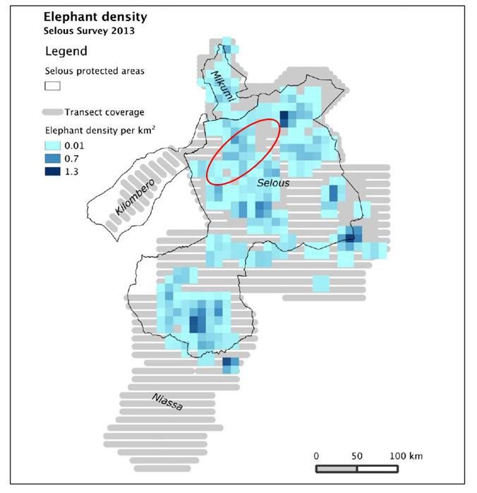
seasonally very patchy (Figure 1).
• The simplistic quantification that is included only considers footprint
impacts – indirect impacts and fragmentation impacts due to the
potential barrier effect of a c.12km wide reservoir could make the
impacts much larger.
• There is no quantification of potential negative or positive social impacts
or impacts on ecosystem services.
Establish management • There is no discussion of the management programmes that will be
programs that identify required to ensure that identified mitigation measures are implemented.
mitigation and A good practice EIA would normally include a list of the management
performance plans that will need to be developed along with their scope and
improvement objectives, and an overview of the process and timeline for developing
measures and actions, them.
including operational
• Mitigation measures are assigned to a wide variety of organisations and
procedures, practices,
will cover a very wide geographical area. There is no discussion about
plans, and related
how the actions will be co-ordinated to ensure they will be implemented
supporting documents
as intended. This is not appropriate for a highly complex project with
that are managed in a
potentially significant impacts.
systematic way
Credible plan to deliver • No plan for delivering no-net-loss or net gain is included in the EIA
no-net-loss or net gain
• Livelihood restoration measures are mentioned, but with no reference to
for biodiversity and
scale, scope, and type, and measures seem to be based on the unlikely
livelihood restoration
assumption that farmers/fishers can easily shift to modern/different
for adverse impacts on
techniques and areas.
Affected Communities
6
The draft EIA (dated May 2018) states that the reservoir’s maximum area will be 1,250km2 or 3% of the area
of SGR, whereas the revised version (October 2018) states that the reservoir’s maximum size will be 914km2 or
1.8% of the area of SGR. No explanation for the different estimates is provided, but presumably the earlier
figure (which seems to be 100 km length x 12.5 km average width) is a crude approximation and the 914km2 is
more precise.
14Key PS1 + 6 Review findings
requirements
Stakeholder • Stakeholder identification emphasises interested parties who stand to
Engagement: Identify gain (primary stakeholders), and secondary stakeholders who can
the range of influence decision-making. This approach is not aligned with PS1 which
stakeholders; requires direct involvement of the Affected Communities (downstream
Stakeholder ecosystem service dependent communities in this case) who are
Engagement Plan, classified as ‘other stakeholders’ and represented by their District
tailored to the Councils.
characteristics and
• While methods are presented, limited information on sampling strategy
interests of the
or representation of Affected Communities, number of meetings or
Affected Communities;
engaged parties is provided. One month of consultation in ‘Villages in
Disclosure of relevant
Lower Rufiji’ is reported (Annex C, page 269), with four bullet points of
project information.
input, and five days of consultation in ‘Villagers in the Rufiji Delta’. No
village names or locations, or information on participants (village leaders,
men, women, youth) is given.
• Based on the number of downstream users – likely tens of thousands of
people – it appears that Affected Communities have not been
adequately consulted as required in PS1. Consultation with potentially
Affected Communities in the lower Rufiji area seems to have lasted five
days for a population of >100,000 people spread across >50 villages,
some of them remote. It is very unlikely that this time would have
permitted a consultation process meeting IFC performance standards
requirements, especially given the complexity of the issues being
discussed and in the absence of an eFlows assessment to inform the
consultation.
• There is no reference to a Stakeholder Engagement Plan nor about
information on how consultation was tailored to local decision-making
processes.
• At least one existing lodge (Azura / Amara River Lodge) is cited as being
under the area to be inundated, but no documentation of engagement
with tourism operators is provided.
For projects with • No ICP is reported in the EIA. Given the potentially significant impacts
potentially significant downstream this appears to be a significant gap.
adverse impacts on
Affected Communities
- Informed
Consultation and
Participation (ICP)
External • There is no mention of a grievance mechanism nor provision for on-going
Communications and reporting in the document.
15Key PS1 + 6 Review findings
requirements
Grievance
Mechanisms, and
Ongoing Reporting to
Affected Communities
Monitoring and • An Environmental and Social Monitoring Plan is provided in the EIA but it
Review provides very general indicators only that are not appropriate for
tracking impacts and mitigation effectiveness to specific priority
biodiversity, OUV or Affected Communities. It is also unclear what pre-
project baseline data would be used for the indicators (as noted above,
there is a lack of data for the Project) or if it will be collected, when this
would happen. It is also unclear which institution listed in the
Environmental Monitoring Plan tables is responsible for collecting and
reporting each of the monitoring indicators; clear roles and
responsibilities and budget lines would be required for each party
undertaking monitoring work.
• There is no description of the proposed evaluation system so it is unclear
how monitoring results would be used to inform adaptive management
of mitigation activities.
16Figure 1 : Results from TAWIRI's aerial surveys show that elephant distribution in the Selous-Mikumi ecosystem is seasonally
patchy. This is a dry-season snapshot from 2013. This illustrates why it is not appropriate to simply use surveys from one
season, and why the proportion of the area of the entire SGR impacted is not a sensible basis for assessing the significance
of reservoir impacts; it also illustrates the rich datasets that are available and which could be used to refine the assessment
of impacts. Map from TAWIRI (2013), with approximate reservoir location added in red.
Review against IUCN’s World Heritage Advice Note on Environmental
Assessment
Table 2 below uses the assessment presented above to summarise the degree of alignment of the
project with the principles of IUCN's World Heritage Advice Note on Environmental Assessment.
Table 2 : Review against the principles of IUCN's World Heritage Advice Note on Environmental Assessment. For further
details please see Table 1 above.
Principle Review findings
1: Rigorous EIA early in • As described above, the EIA has too many gaps and inconsistencies in all
decision-making components to be considered rigorous. It has also not been conducted
process early in the decision-making process as it appears that construction may
already have begun.
2: Appropriate experts • Although a list of experts is included, insufficient information is provided
to assess whether they had appropriate World Heritage, protected area
and biodiversity knowledge.
17Principle Review findings
• For project of this nature, global and regional experts would be expected
to be consulted, but no list of such experts is provided.
3: Impacts on OUVs • The data used to assess impacts is at an inappropriately low level of
assessed, including resolution. Significant sources of secondary data do not seem to have
direct, indirect and been used (or not used to an appropriate extent), and primary data is
cumulative impacts very limited.
• Impacts on the OUV are assessed, but not at an appropriate level of
resolution: impacts to individual features contributing to the OUV are
not assessed individually; neither are they quantified.
• Several potential impact types are not assessed at all, including the
barrier effect of the dam for migratory fish, and of the reservoir for
mobile terrestrial species.
• Assessment of indirect and cumulative impacts is limited.
4: Analysis of • The analysis of alternatives is weak and focuses principally on different
alternatives construction options, not on different ways to generate power or design
choices that could reduce impacts (such as adjusting the dam height to
reduce reservoir size).
5: Mitigation Hierarchy • As discussed above, the mitigation hierarchy does not seem to have been
systematically followed. In particular, there is limited attention to
avoidance, and even some basic minimisation measures that are good
practice for hydropower projects have not been assessed.
• Mitigation measures are generally 1) not clearly linked to impacts,
and/or 2) insufficiently detailed, and/or 3) not demonstrably feasible,
and/or 4) insufficiently resourced. They therefore do not provide
confidence that identified impacts will be avoided and minimised as far
as feasible.
6: Chapter on World • A separate chapter on World Heritage status is provided, however the
Heritage with clear conclusions about impacts on the OUV are vague and in some cases
conclusions about contradict assertions elsewhere in the EIA (for example about impacts on
impacts on OUVs sand rivers).
• No quantification of impacts to individual biodiversity features that are
cited as contributing to listing under criteria (ix) and (x) is provided, so
the overall conclusion of a positive effect cannot be substantiated and is
not credible.
18Principle Review findings
7: Public disclosure and • No information on public disclosure is available, so this cannot be
thorough public assessed.
consultation
• Public consultation was limited, especially given the number of potential
Affected Communities, and does not meet international good practice
standards. No process of Informed Consultation and Participation was
undertaken.
8: Environmental • An environmental management plan is presented but details of how it
Management Plan will be implemented, including the scope of requirement operational
management plans is not provided.
• No description of the overall monitoring, evaluation and assurance
process is provided, and no provision for independent auditing is made.
Conclusions and implications
Key findings
The analysis documented above identifies many significant gaps in terms of project
description, baseline information, impact assessment, mitigation design and
implementation planning. The reviewed EIA therefore falls considerably short of
international standards for a project with potentially significant impacts in an area of
such high biodiversity and social sensitivity. It is therefore not appropriate for a large-
scale development like the Stiegler’s Gorge hydropower project. In particular, the
reviewed EIA does not provide confidence that:
• potentially highly significant negative social and environmental impacts have
been assessed with a level of resolution and precision appropriate for the nature
and scale of the impacts;
• relevant and effective avoidance and minimisation measures have been identified;
• residual impacts will be addressed to ensure that negatively-affected
livelihoods will be restored and that an overall net gain or no-net-loss of
biodiversity will be delivered.
The most significant areas of divergence from international standards are:
• An inadequately detailed description of the project activities. In particular, there
is insufficient detail on the planned flow regime, including both the likelihood or
frequency of implementation of a hydropeaking regime, the expected level of
seasonal variation in flows and the expected constraints to flows, for example in
cases of prolonged drought.
• Insufficient consideration of associated facilities, notably the required
transmission line and access roads.
• Baseline data are largely lacking and are frequently based on insufficient, out
of date or irrelevant information, with significant gaps.
• Insufficient modelling of downstream flows and the absence of an environmental flows
(eFlows) assessment.
19You can also read