Defendable space in the Bushfire Management Overlay
←
→
Page content transcription
If your browser does not render page correctly, please read the page content below
Advisory Note | 44
February 2012
Defendable space in the
Bushfire Management Overlay
Amendment VC83 introduced a Background to new defendable
definition for defendable space and space requirements
revised defendable space requirements New defendable space requirements have
at clause 52.47. This advisory note been developed in response to the 2009
outlines the technical inputs used to Victorian Bushfires Royal Commission
develop the new defendable space (VBRC). The new requirements in the
requirements. BMO and clause 52.47:
integrate with the nationally consistent
What is defendable space? approach to bushfire attack levels
The creation of defendable space (BAL) used to determine construction
is a requirement under the Bushfire requirements for new buildings
Management Overlay (BMO) and clause
use the site assessment methodology
52.47. Defendable space is defined
at clause 72 of the Victoria Planning in AS3959-2009 Building in a bushfire
Provisions. prone area (Standards Australia)
maintain the same level of bushfire
Defendable space is an area of land
around a building where vegetation is protection required under the Wildfire
modified and managed to reduce the Management Overlay that applied
effects of flame contact and radiant heat before 18 November 2011.
associated with bushfire. It comprises an ensure that a building will not be
inner zone and an outer zone. subject to sustained flame contact
See Appendix 2 of practice note 65: except where it is assessed as Bushfire
Bushfire Management Overlay and Attack Level Flame Zone (BAL-FZ).
bushfire protection: planning requirements
for information on how vegetation is
intended to be managed in both the inner
and outer zones.
INNER ZONE OUTER ZONE UNMODIFIED VEGETATION
(hazard)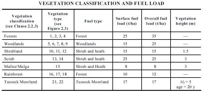
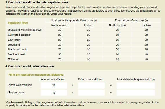
Developing the defendable space The defendable space requirements in Table 2
requirements of clause 52.47 ensure that a building is located
so that it is not exposed to a radiant heat flux
The University of Technology Sydney (UTS)
more than 10kw/m2, based on the AS3959-2009
developed the new defendable space
Method B approach using an FFDI of 120 and a
requirements contained in Table 1 of clause
flame temperature of 1200Kelvin. This standard
52.47. The UTS examined the impact of modifying
is considered the most suitable performance
a number of the AS3959-2009 input parameters
requirement because:
to meet the bushfire protection objectives of the
BMO. It concluded that the defendable space it is the maximum a fire fighter in personal
requirements should be based on: protective equipment can be exposed to for
a short period of time (less than 10 seconds),
an inner zone distance as specified by AS
providing some potential to evacuate or
3959-2009 for a particular BAL
defend buildings occupied by people with
an outer zone developed using the special needs
methodology of AS3959-2009 – Appendix B
it aligns with the criteria for Neighbourhood
but with the following changes:
Safer Places in Victoria
a Forest Fire Danger Index (FFDI) of 120
it provides a conservative approach for
(instead of 100)
determining defendable space for uses at
a flame temperature of 1200Kelvin (instead particular risk.
of 1090Kelvin).
The defendable space requirements in Tables
A copy of the UTS report is attached to this 1 and 2 have also been jointly endorsed by
Advisory Note. The report has some references the Department of Planning and Community
to the previous Wildfire Management Overlay Development, the Country Fire Authority, the
because it was prepared before Amendment Building Commission and the Department of
VC83. Sustainability and Environment.
Published by the Victorian Government Department of Planning and Community Development, Melbourne, February 2012.
© The State of Victoria Department of Planning and Community Development 2012.
This publication is copyright. No part may be reproduced by any process except in accordance with the provisions of the Copyright Act 1968.
Authorised by the Victorian Government, 1 Spring Street, Melbourne.
This publication may be of assistance to you but the State of Victoria and its employees do not guarantee that the publication is without flaw
of any kind or is wholly appropriate for your particular purposes and therefore disclaims all liability for any error, loss or other consequence
which may arise from you relying on any information in this publication.
www.dpcd.vic.gov.au/planning
Advisory Note 44 | Defendable space in the Bushfire Management Overlay 2Report to the Country Fire Authority
in relation to the Implementation of Defensible
Space and BAL levels for planning and building in
WMO Areas.
By Grahame Douglas.
Associate – Centre for Local Government.
January 2011
University of Technology Sydney PO Box 123 Broadway NSW 2007 Australia
Ph: +61 2 9514 1659 Fax: +61 2 9514 2274 Email: clg@uts.edu.auContents.
Executive Summary
1. Introduction
2. Current challenges.
3. Overview of View Factor Method used in AS3959-2009.
3.1 What is View Factor?
3.2 View Factor Method.
4. Potential Limitations of WMO and View Factor Approaches.
4.1 Elements of WMO.
4.2 Vegetation management considerations.
4.3 Vegetation classifications.
4.4 Aspect.
4.5 Flame temperature and lengths.
4.6 Fire Behaviour equations.
4.7 Determining maximal setback distances
5. Developing planning tables for consistency with AS3959-2009.
5.1 Basis of planning tables.
5.2 Determination of planning tables.
6. Conclusion.
7. Recommendations.
References.
Appendices.
Appendix 1 – Tables for determining defendable space requirements
Appendix 2 – Defendable spaces for planning purposes under a revised WMO.
Appendix 3 – Media release of 2 September 2010 (Building Commission website).
Appendix 4 – FFDI 100 tables (Table 2.4.2) from AS 3959-2009.
iiExecutive Summary.
The Country Fire Authority of Victoria (CFA) engaged the University of Technology –
Centre for Local Government, to prepare a report on the development of tables for
defendable space to support the Victorian Government’s objective of a more integrated and
consistent approach to both WMO and BAL assessment processes.
The Country Fire Authority (CFA), Department of Planning and Community Development
(DPCD) and the Building Commission (BC) have agreed that the AS3959-2009 site
assessment process will be adopted as a basis of this process. A requirement of the CFA is
that such a system maintains equivalency in terms of protection of life and property as the
existing WMO process.
It is concluded that the best option for meeting the bushfire protection objectives of the
Victoria Panning Provisions (VPP) and fully integrate with the Victorian Building
Regulations including the BAL assessment under AS3959-2009 is to determine:
o An inner protection zone based on the distances specified by AS 3959-2009 for
a particular BAL; and
o An outer vegetation management zone, which utilises the methodology of
AS3959-2009 – Appendix B and the following input parameters :
o an FFDI of 120
o a flame temperature 1200K
o all other input parameters as per AS3959-2009 (except for wet forests)
These two ‘zones’ require different levels of vegetation management with the net result
being an overall reduction in defendable space requirements balanced by a greater intensity
of vegetation management. Some adaptation to the outer area will be necessary for
subdivisions where dwellings are not directly facing the bushfire hazard.
This report has developed recommendations which if accepted:
o Allows Victoria to adopt the nationally consistent approach to assessing the BAL
for a site;
o Maintains equivalency in terms of life and property protection to the current WMO
methodology and requirements;
o Ensures that a building will not be subject to sustained flame contact other than
where it is assessed as BAL – FZ;
o Meets the recommendations and findings of the VBRC regarding site assessment
methodology and mapping of bushfire affected areas;
o Integrates the approach used for bushfire attack level assessments in both the
planning and building regimes to form a single approach to site assessments in
Victoria;
o Provides a range of acceptable (DTS) planning solutions from BAL 12.5 through to
BAL 29 in contrast to only BAL 29 in the current process. In some cases BAL 40
may also be used (dwellings on existing allotments).
iii1. Introduction.
The Country Fire Authority (CFA) engaged the University of Technology, Sydney
(Centre for Local Government) to provide advice in relation to the operation of
AS3959-2009 and its relationship to the Wildfire Management Overlay (WMO). The
aim of the review is to better integrate BAL assessments as applied in Victoria under
the Building Regulations (through the Building Code of Australia) and the planning
requirements of the Victoria Planning Provisions (clause 44.06) and in particular the
WMO assessment process undertaken by the CFA.
Currently there are two approaches within the Victorian planning and building
systems for determining the radiant heat impacts on a building from bushfire. These
are generally known as the WMO method (Maughan & Krusel 2005) and the ‘View
Factor’ method (Douglas & Tan 2005). The view factor method is incorporated into
the building standard AS 3959-2009. It is a physical based model and draws upon
empirical data to determine flame characteristics. In both cases this modelling is an
estimate of the radiant heat flux which may be received from a bushfire front, relative
to a given point. This estimate of radiant heat flux is then used to determine
defendable space and the required construction level (BAL). To be able to make this
estimate various assumptions about the bush fire front and how it will emit energy
need to be made.
In essence the calculation of radiant heat in both the WMO and AS 3959 methodology
follows a similar process, in that:
o Fire spread models are used to determine how a fire is likely to move across
the landscape;
o Models are used to determine flame length and fireline intensity; and
o A model is used to determine how this flame will emit radiation and how that
energy will be received by a structure.
In some cases however, the elements within the models vary between the WMO and
AS 3959 methodologies. Another variance between the two methodologies is the
design parameters and assumptions used in the modelling process. The variance in
these assumptions can lead to significantly different outcomes.
The Victorian Government announced on 2 September 2010: “To remove the
inconsistency created by the different processes, the CFA, the Department of Planning
and Community Development (DPCD) and the Building Commission formed a joint
working group to consider developing single site assessment guidelines”. The work
provided by this report is to be used in support of that work.
The CFA engaged the University of Technology Sydney (UTS), to prepare a report
and derive tables for defendable space in support of the Victorian Government’s
objective set out in its media release of 2 September 2010 (see Appendix 3).
In addition, the Victorian Bushfires Royal Commission (VBRC) Final Report (the
Commission’s Report) requires within Recommendation 37.3 that the State:
“finalise the alignment of a site assessment methods for planning and building
purposes, taking into account bushfire risk to human safety as well as property.”
1The supporting commentary in the Commission’s Report (pp.223-224, VBRC, Vol.2)
suggest this single site assessment process should be based on the process included in
AS 3959-2009. The key agencies responsible; CFA, DPCD and the Building
Commission have agreed that the AS 3959-2009 site assessment will be adopted as
the state’s single site assessment method. This provides for a nationally consistent
approach. It was also agreed that this future single site assessment approach needs to
be supported by a suitable vegetation assessment and management regime which
maintains, at minimum, equivalent life safety outcomes to the current WMO
requirements.
There are a number of other advantages in adopting the View Factor Method to
determine defendable space requirements. Consistency in the approach to modelling
both radiant heat and defendable space streamlines training requirements and
simplifies community engagement processes. The View Factor Method is also more
suited to complex alternative solutions than the current WMO method and is
significantly better understood by the fire engineering industry.
The Commission’s Report also recommended a review of the 100 metre assessment
zone criteria used in both AS3959-2009 and the current WMO (see p.223, VBRC,
Vol.2).
In engaging UTS, the CFA identified a number of scenarios to be considered. These
are:
Scenario 1
• Fire Danger Index (FDI)- 120
• Flame Temperature- 1200 deg Kelvin
• Flame Length (forest) - Modified McArthur (Douglas & Tan 2005)
Scenario 2
• Fire Danger Index (FDI)- 120
• Flame Temperature- 1200 deg Kelvin
• Full flame length (forest) - McArthur (expressed by Noble et al 1980)
Scenario 3
• WMO criteria.
CFA required these scenarios be presented as a report, including a series of tables
which:
• Provides an overview of the science utilised to determine the figures within
these tables;
• Sets out the potential limitations of these tables/ scenarios;
• Discusses the usefulness of these tables within the Victorian system;
• Provides a comparative analysis between the existing WMO site assessment
approach and the proposed use of AS 3959-2009 complemented by
enhanced vegetation management as recommended by this report. In
particular an analysis of the level of safety of the dwelling and occupier
when compared against the two systems.
2The main task is to develop two tables. These are presented in a format comparable to
those in AS3959-2009 (set out in Appendix 1 of this report).
These tables must also consider:
• Vegetation type;
• Slope;
• Distance of vegetation from a proposed dwelling; and
• Suitable fire weather conditions to reflect the events of Ash
Wednesday (in 1983) and Black Saturday (in 2009).
The resultant outputs are also compared to the existing relevant tables in AS3959-
2009 to ensure appropriate integration into the overall site assessment process. Having
completed these tables, a series of planning tables were developed to support
integration with AS3959-2009. This allows for the provision of a BAL consistent
with building requirements and an overall defendable space as a planning
requirement. These are set out in Appendix 2.
32. Current challenges.
The WMO and the BAL assessment processes currently use different approaches and
methods in assessing the impact of bushfire attack on structures. These approaches are
not compatible and rely on differing assumptions, procedures and methodology.
The WMO method is based on the work of Leicester (1987) and corrected for flame
length (Maughan & Krusel (2005) and other factors (Burke and Leonard, 2010). The
advantage of this method is that is a relatively simple method which limits fire line
intensity and identifies a threshold radiant heat of 29 kW/m2. It also generates
significantly greater distances than determined under the Building Regulations and
AS3959-2009. However, the WMO method has advantages. Houses subject to WMO
requirements were roughly three times more likely to have survived the Black
Saturday fires than houses built to no requirements (Holland, et al 2009).
The BAL assessment process is taken from AS 3959-2009 (Appendix B: Method 2)
and is derived from the work of Douglas and Tan (2005). It is used in NSW through
the Planning for Bush Fire Protection 2006 (RFS, 2006). The NSW system was
originally developed on different fuel assumptions and cannot be used as a direct
comparison with either the BAL assessment under AS3959-2009 or with that of the
WMO. However, the approach has been adopted by AS3959-2009 and provides for
variable input parameters (including vegetation, fire weather and flame
characteristics) which can generally be considered more appropriate in the Victorian
context.
It should also be noted that the concept of a planning approach and that of addressing
the BCA seeks to address different aspects of bushfire protection.
The BCA provides for the protection of life safety and amenity whereas planning
aspects should also address the considerations of fire fighting operations, property
protection, ability for access and movement around structures, evacuation and broader
community resilience through retention of built form and infrastructure. These are not
necessarily incompatible but require a more cautious approach by planners than the
considerations of the building codes alone.
Table 1 lists some of the opportunities and constraints of the WMO versus the View
Factor method which include levels of conservatism, vegetation management and
suitability for Victorian conditions.
An additional challenge is to reconcile the Victorian vegetation system (EVCs) with
that of AS3959-2009. Significant progress has been made by the author in progressing
this with the use of a key and the descriptors and mapping of EVCs. This is
preliminary work and warrants further refinement in collaboration with the Country
Fire Authority and the Department of Sustainability and Environment.
4Method Pros Cons Comments
WMO Although the current May give rise to The vegetation
Method approach is considered by uneconomic and management
some to be extremely unsustainable land –use distances resulting
conservative it was shown to decisions in achieving larger from this conservative
be more effective than no defendable space. approach to
controls on Black Saturday. modelling radiant
Being overly conservative heat is balanced by a
Based on input assumptions has resulted at times in: requirement to
tailored for Victoria. • CFA being criticised and remove less fuels/
accused of inhibiting vegetation as part of
A Victorian document to development management
update and edit as • CFA being out of step requirements.
necessary. with the rest of the
country Overall increased
Has been in place for a • CFA approach not being vegetation
substantial period of time backed up by a detailed management and
and understood by CFA peer review loss of biodiversity.
staff.
Less suitable for developing Slope assumed as 10
complex fire engineered degrees, slopes >
design or for complex site than this require an
assessment, including steep alternate solution.
slopes.
Vegetation management of
outer zone can be
confused. This can lead to
increased hazard.
Vegetation descriptors do
not directly match EVCs or
AUSLIG systems.
View Factor Nationally consistent As applied in AS 3959-2009 AS 3959-2009
Method approach. may result in a significant assumes FFDI of 100
risk arising from the more and considers there
Peer reviewed and well severe fire associated with will be virtually no
accepted by fire engineering Ash Wednesday and Black vegetation between
professionals. Saturday conditions. the development and
the assessed
More suitable for developing Input parameters based on vegetation
complex fire engineered nationally focused
design or for complex site assumptions. There is a need to
assessment, including steep complement AS
slopes Content controlled by a 3959-2009
national industry based requirements with
Enhanced opportunities for committee which is only enhanced vegetation
flexible land-use decision loosely influenced by management.
making. Victorian agencies.
Overall reduced
Vegetation management Fire conditions of Ash vegetation
arrangements clearer. Wednesday and Black disturbance and loss
Saturday not used for of biodiversity.
Vegetation based on Victoria.
AUSLIG system. Increased range of
Need to link EVCs to slopes available from
AUSLIG vegetation classes. DTS tables, without
the need for an
alternate solution.
Table 1: Opportunities and constraints of WMO and View factors methods.
53. Overview of “View Factor” Method used in AS3959-2009.
3.1 What is “View Factor”?
The term “View Factor” is used to describe the physical basis of heat transfer through
a medium (air) with a resultant radiant heat load on a surface. The view factor is a
function of flame length, flame angle, slope, distance and height of radiation receiving
point (see Figure 1 below). In addition, emissivity needs to be taken into account
based on flame depth. Emissivity can range between 0.9 and 1.0.
The view factor method used to calculate the radiant heat flux in AS 3959-2009 (see
Appendix B of AS 3959-2009) is the well established view factor method and
expressed as (Drysdale 1985):
Rd = φ ε σ T4
Where
Rd = radiant heat flux without atmospheric attenuation (kW/m2)
φ = view factor
ε = flame emissivity
σ = 5.67 x 10⁻¹¹ kW/m2
T = flame temperature (K)
When considering the effects of atmospheric attenuation, the above radiant heat
equation can be mathematically expressed by:
Rd (τ) = φ ε σ T4 τ
Where
Rd (τ) = radiant heat flux with atmospheric attenuation (kW/m2)
τ = transmittance factor
Atmospheric attenuation occurs as a result of the presence of moisture (humidity) and
carbon dioxide in the atmosphere and in the path of the receiver and heat source (i.e.
bushfire).
For construction purposes, atmospheric attention and emissivity are used to moderate
radiant heat. For forest (including rainforest) and woodland vegetation classes, the
bushfire flame front is adjusted for flame height (compared to flame length),
discontinuities of flame and variations of flame temperature (PBP, 2006). These
modifications are not made in relation to scrub and shrubland fuels were the effects on
flame height and discontinuities are not as pronounced.
According to the radiant heat flux equation shown above, the radiant heat flux
received by a point at a distance from fire front is the function of flame temperature,
flame emissivity, view factor and transmittance. Flame temperature and flame
emissivity are generally considered as constants. For bushfire applications, flame
temperature is in a range of 1000K - 1300K (Vines 1981; Sullivan et al. 2003).
The view factor equation appears to be a simpler equation than that of Leicester
(1987), however, it is complicated by the calculation of the relevant ‘view factor’.
6Figure 1. Flame characteristics (height and length) (source: CSIRO).
To bring this into context therefore, one must consider the overall approach to be
taken in developing a methodology for refining the current WMO methodology and
integrating it with AS3959-2009.
The determination of the relevant view factor becomes the key for radiant heat flux
modelling within the view factor model. In order to derive the view factor for the
inclined flame show in Figure 2, it is assumed that the view factor of an inclined
flame is equivalent to that of a vertical flame with the same height located in the mid
way of the flame.
This assumption is justified by CSIRO’s research finding that the radiation at a
distance from a tilted fire front can be well modelled by the vertical flame with the
same flame height located in the mid way of the flame (Sullivan et al. 2003).
Based on the above assumption, the view factor of a point with a distance of ‘d’ from
the base of the flame at an elevation of ‘h’ on the vertical plane crossing the vertical
axis of the flame can be derived and expressed as (Tan et al, 2005):
1 X1 Y1 Y1 X1
φ= { tan-1[ ]+ tan-1[ ]+
π 1+ X1
2
1+ X1
2
1 + Y1
2
1 + Y1
2
X2 Y2 Y2 X2
tan-1[ ]+ tan-1[ ]}
2 2 2 2
1+ X 2 1+ X 2 1 + Y2 1 + Y2
X1= (Lf sinα-0.5Lfcosα tanθ -d tanθ – h)/(d –0.5Lfcosα)
X2= [h + (d-0.5Lf cosα) tanθ]/(d–0.5Lfcosα)
Y1= (0.5Wf)/ (d –0.5Lf cosα)
Y2 = (0.5Wf)/ (d –0.5Lf cosα)
Where
Lf = flame length in meters,
Wf = flame width in meters, defaulted as 100m
7h = elevation of receiver in meters, defaulted as the level opposite to flame
centre
α = flame angle in degrees
θ = slope between vegetation and structure in degrees
d = separation distance in meters.
Figure 2: Diagram for deriving view factor of inclined flame (Tan et al, 2005)
The view factor formula above suggests that the calculation of view factor for inclined
flame requires the five inputs which are flame length, flame width, flame angle,
elevation of receiver, and site slope. For a given vegetation type and a design fire
weather condition, flame height can be determined through the flame length
modelling process described previously. Flame width is assumed to be 100m which is
considered to be a conservative for bushfire applications (Ellis 2000). Site slope and
elevation of receiver can be determined in accordance with the conditions of the given
site. Therefore, when flame length, flame width, site slope and elevation of receiver
are known, view factor becomes the function of flame angle only and reaches the
maximum at a certain flame angle. Radiant heat is determined from the centre of the
flame (Tan et al, 2005).
80.3500
0.3000
0.2500
View Factor
0.2000
0.1500
0.1000
0.0500
0.0000
0 10 20 30 40 50 60 70 80 90 100 110 120 130 140 150 160 170 180
Flam e Angle (degree)
Figure 3. Relationship between view factor and flame angle
As an example, the view factors for a series of flame angles under the condition that
elevation of receiver =2m, site slope = 0 degree, flame length = 20m, flame width =
100m and separation distance =30m can be determined with the view factor formula
and the results are shown in Figure 3. These conditions (except distance & flame
height) correspond to the criteria used for Guidelines for Neighbourhood Safer Places
(CFA, 2010).
3.2 View Factor Method.
The use of view factor is contingent on determining flame geometry. As such, the
process of determining radiant heat using view factor method is a staged approach in
which initially the bushfire behaviour equations are used to determine flame
geometry, and secondly the use of appropriate inputs to derive radiant heat from the
flame.
This overall ‘site assessment methodology’ for planning purposes is generally shown
in Figure 4 below:
The algorithm for iteratively determining the view factor component of the flowchart
above is provided by Douglas and Tan (2005). In addition, the attenuation component
is also set out and follows from the work of Fuss and Hamins (2002). Atmospheric
attenuation is not used and flame temperatures are higher (1200K) in determining
NSPs due its more conservative assessment requirements.
9Begin
Obtain Site Specific Data
(vegetation, slope and location)
d>= 100m or NSP
criteria.
No
Yes
Determine FDI or wind speed
Calculate Rate of Spread
Calculate Fire Intensity
Determine Flame Dimensions
Calculate View Factor
Determine Transmissivity
Determine Flame temperature
Determine Radiant Heat
(with atmospheric attenuation)
Determine Overall
Defendable Space
Determine BAL level for
inner area & construction.
End
Figure 4: Flowchart of the View factor Site Assessment (Planning)
104. Potential limitations of WMO and View Factor approaches.
4.1 Elements of the WMO.
According to Maughan and Krusel (2005), the fire weather conditions associated with
Ash Wednesday are used to set the design fire parameters underpinning the WMO
methodology. This has been generally accepted at about FFDI = 120. (41 C0, RH =
5%, wind speed @ 45+kph, DF 10).
Under the WMO (Maughan and Krusel, 2005), surface fuel loads for different
vegetation classes correspond to steady state conditions for the purposes of
determining forward rates of spread, and fire line intensity is based on overall fuel
loads. Slope is considered to allow the fire to run uphill (referred to as downslope in
AS3959) and overall fire line intensity is limited to 120,000 kW/m for forest fires
(also assumed to be for heath fires) and 60,000 kW/m for grass fires. Radiant heat is
calculated from the flame tip and such, flame length is added to the overall Leicester
(1987) calculation.
A radiant heat flux of 29kW/m2 is used as a threshold in determining the setback,
although flame length and other factors are used in addition to the radiant heat (Burke
and Leonard, 2010).
4.2 Vegetation management considerations.
Of major interest has been the derivation of inner and outer zones to calculate overall
widths. For the WMO, the first 10 metres is taken as an inner area of intensely
managed vegetation. An outer area is then applied subject to aspect, slope and
vegetation type.
Currently under the standard WMO requirements two standards of vegetation
management are prescribed, an inner and outer zone, which must be managed during
the declared ‘Fire Danger Period’. The vegetation management arrangements for the
Inner and Outer Zones are described in Table 2 below (CFA, 2010a).
Inner Zone Standard Conditions Outer Zone Standard Conditions:
• Grass must be no more than 100mm in height • Grass must be no more than 100 mm in height
• Leaf litter must be less than 10mm deep • Leaf litter must be less than 20 mm deep
• There must be no elevated fuel on at least • There must be no elevated fuel on at least 50%
50% of the area. On the remaining 50% the of the outer zone area
elevated fuel must be at most, sparse, with • Clumps of dry shrubs must be isolated from
very little dead material one another by at least ten metres
• Dry shrubs must be isolated in small clumps
more than ten metres away from the dwelling
• Trees must not overhang the roofline of the
dwelling.
Table 2: Vegetation management for WMO (inner and outer) zones.
Lower risk vegetation such as grasslands and semi urban areas are only managed to
the inner zone conditions.
11The WMO outer zone vegetation management requirements are intended to manage
ground and elevated fuels to the extent where a crown fire will not occur. These
requirements do not include the removal of trees, unless they are overhanging the
building. Outer zone vegetation management requirements were developed with the
retention of native vegetation in mind and derived such that maximum native
vegetation retention could occur while at the same time eliminating the chance of a
canopy fire. The VBRC Final report however was critical of the way CFA expressed
its standard vegetation management conditions and their potential for
misinterpretation (p.238, VBRC, Vol.2). They also considered life safety should not
be compromised by the retention of vegetation, a position supported by the Victorian
Government and CFA’s responsibilities under Section 20 of the Country Fire
Authority Act 1958.
Predominantly in forest type vegetation, the misinterpretation or strict interpretation
of CFA’s standard vegetation management conditions can lead to situations were
retained ground and elevated fuels will potentially lead to the development of a
canopy fire and a significant underestimation of the impact of fire and capacity for
flame impingement on a structure. This has the greatest potential to occur under
extreme fire weather condition and in areas of severe slope.
The following table is taken from the WMO workbook (2010) and is used to illustrate
the derived distances for 29 kW/m2 (other than grassland and cultivated gardens).
Table 3: Defendable space requirements for WMO (CFA, 2010b).
The assessment under AS3959-2009 assumes a higher degree of vegetation
management with park like gardens and little in the way of significant vegetation.
This is of course, not to suggest that some vegetation cannot be found within the
distance to vegetation described within AS3959-2009 (well designed garden beds and
some trees are permitted). Exclusions (low threat vegetation) are set out in the
Standard.
12The terms defendable space, inner and outer zone suggests different levels of maintenance which may warrant careful consideration. In many jurisdictions, it is accepted that for forest vegetation that an outer zone would be modified and managed similar to that of an open grassy woodland, with a canopy cover of
Table 5: Vegetation classes and fuel loads used in WMO (from Maughan & Krusel,
2005).

In adopting the site assessment approach used in AS3959-2009 it will also be
necessary to utilise the vegetation types and classification of AS3959-2009. In most
instances this will provide an acceptable outcome however, this should be enhanced
by the development of supporting information linking the Victorian system of
Ecological Vegetation Classes (EVCs). The linkage of EVCs to the AS3959-2009
vegetation classification system should be formalised in either the future guideline for
Victoria’s single site assessment process or a formal DPCD, CFA or Building
Commission practice note. This should be done in collaboration with the Department
of Sustainability and Environment. This information could also prescribe more
detailed fuel loads for use in alternative solutions/ the Method 2 process (AS 3959-
2009 pp.84-93). Method 2 also recognises that fuel loads can be derived from “other
data sets provided by the relevant fire authority for the site” (Standards Australia,
2009) which in Victoria is the CFA.

An issue which needs careful consideration is potential fuel loads in Victorian wet
forests (also referred to as Tall Forests) compared to the assumed fuel load for forests
in AS3959-2009. Under the current WMO process an overall fuel load of 40 t/ha and
surface fine fuel load of 30 t/ha is assumed for wet/ tall forest types. Under the forest
classification in AS 3959-2009 an overall fuel load of 35 t/ha and surface fine fuel
load of 25 t/ha is assumed, equivalent to the WMO medium forest classification.
According to Tolhurst (2009) some of the Black Saturday fires in wet forest
consumed fuel loads of up to 50 t/ha overall. A specific outer vegetation management
zone may be necessary for this forest type.

For vegetation not within the forest classification (including woodlands), the issue of
outer zone management arrangements are more problematic. For example, heathland
(scrub and shrubland) fire behaviour is dictated by vegetation height rather than
canopy cover or density of plants. In addition, wind speed is the major driver of rate
of spread and fire line intensity. An outer zone should be subject to a requirement of
less than 50% canopy cover for these vegetation types.

Rainforest vegetation is unlikely to be subject to significant modification on
environmental grounds, other than for weed management, and in any case is less
prevalent within the Victorian landscape. For grassland vegetation, any concept of an
outer zone is both theoretical and impractical. Grasslands setback requirements are
likely to form part of Amendment 2 to AS3959-2009.

The role of outer zones is also difficult to apply to housing in the second or
subsequent rows of houses in a new subdivision, where it may be assumed that some
shielding may occur. This will need to be recognised in any revision of the WMO.

                                           14
4.4 Aspect and Weather.
The WMO method provides for significant concessions in relation to aspect. It is
unclear in the current documentation why such a concession is provided. It is assumed
that this concession is based on the premise that severe fire weather in Victoria
predominantly emanates from the north followed by a south-westerly wind change. In
Victoria and southern NSW, it is known that fires occur more frequently and have
lower fuel moisture on northerly – south-westerly aspects and fuel loads on easterly
aspects are usually higher. During protracted periods of drought as experienced
leading up to 2009, fuel moisture on easterly aspects do not retain the assumed
moisture levels and are still subject to severe wildfire.
It is also difficult to address other conditions such as wind at this time as work arising
from the ACT fires and Black Saturday fires in Victoria suggest significant impacts
on leeward slopes arising from channelling and eddies (Sharples 2009, Douglas et al
2010). There does not appear to be good information on the criteria for the reduced
FFDI (of 70) used on easterly aspects under the WMO.
In a study by the Bureau of Meteorology (Long 2006), nearly 72% of extreme fire
weather days (EFWD) recorded at Melbourne Airport were from the direction of
north, followed by 9% from the NNW, 7% from the NW and 3.2% from the WNW.
No EFWD’s were recorded from the directions of E, ENE, ESE, SSE, SSW, with only
small percentages (i.e. less than 1% each) from all other directions. Although the
frequency of such events can vary considerably across the landscape, the trends at
other Victorian locations (Mildura, East Sale and Mt Gambier) showed similar trends
with N, NNW, NW and W directions dominating EFWD’s and E and S directions
representing minimal frequencies (Long 2006). The results of the study also indicate
that the extreme conditions occurred between 1200hrs and 1500hrs local time.
In contrast, during the Black Saturday fires, there was an observed phenomenon of
pyro-convective plumes commented upon at the Royal Commission (Tolhurst 2009).
Other studies by Sharples (2009) and Douglas et al (2010) are strongly suggestive that
for areas with strong relief, caution should be exercised in using aspect to reduce
protective measures.
This is also reflected in the application of AS3959-2009, in which aspect does not
have a factor when assessing BAL levels. In the light of the role of leeward eddies and
channelling, it is not appropriate to have aspect incorporated as part of the revised
criteria for defendable space.
4.5 Flame temperature and lengths.
Flame temperature within AS3959-2009 is based on a value of 1090K. The use of an
appropriate flame temperature is an important consideration. The View Factor Method
within AS3959-2009 relies on temperature to the fourth power (i.e. T4) as described in
Burke and Leonard (2010) and Knight (2004). It has been noted that flame
temperatures can vary above the established 1090K used in AS3959-2009. In NSW,
special fire protection purpose developments are assessed in relation to a 1200K flame
temperature when planning for human exposure. Neighbourhood Safer Places for
example are assessed using a flame temperature of 1200K (CFA 2010a).
15The differences between flame temperatures of 1090K and 1200K can therefore be
used for planning purposes, so long as this provides a level of consistency with
AS3959-2009. The choice of flame temperature is largely one of a policy nature so as
to ensure improve safety. Understandably, the CFA want to maintain a high standard
as applied through the WMO.
Flame lengths and flame heights are not the same (Maughan and Krusel, 2005). This
is illustrated in Figure 1 and described in section 2 above. The AS3959-2009
methodology uses the modified McArthur equations for forest flame height (Douglas
and Tan 2002), whereas according to Maughan and Krusel (2005) the WMO uses the
method used by Alexander (1982) but capping intensity to 120,000 kW/m.
As the flame is pushed towards the ground under the influence of a fire and wind, the
flame height is correspondingly reduced. An inclined flame will approach the receiver
however the theoretical flame will be smaller. At an angle of 45 degrees the tilted
flame will be approximately half the height of the flame length. In addition, forest
flames have significant discontinuities, and have highly variable flame temperatures
across the fire face. This is exaggerated when flame geometry is based on tree canopy
in addition to litter/understorey fuels. A limitation of the McArthur’s formula though
is that it is appropriate for lower intensity fires not involving the canopy.
4.6 Fire behaviour equations.
The use of appropriate fire behaviour equations is necessary in considering the two
approaches (i.e. WMO vs View Factor).
(i) Rate of Spread.
The objective of rate of spread modelling is to provide the inputs required for fire
intensity calculation and flame length modelling. Depending on the vegetation
classification, the rate of fire spread shall be modelled by one of the equations shown
in Table 6. Table 6 includes slope adjusted rate of spread.
Vegetation Rate of Spread (km/hr)
Forest & Woodland
R=0.0012 *FDI*w *exp (0.069*slope)
(Noble et al. 1980)
Shrub & Heath
R= 0.023 *V1.21 *VH0.54 * exp(0.069* slope)
(Catchpole et al. 1998)
Where: FDI = forest fire index
w = surface fuel load (t/ha)
slope = effective slope (degrees)
VH = average height of vegetation (m), defined in Table 2
V = average wind speed at 10m above ground, defaulted as 45km/h
Table 6: Rate of Spread Equations (adapted from AS3959-2009)
(ii) Fire Intensity.
The objective of fire line intensity calculation is to provide the input required by
modelling flame length for grasslands, shrub and heath. Fire intensity shall be
16calculated by using the well-known Byram Equation which is mathematically
expressed as (Byram 1959):
I = H*W*R/36
Where
I =fire intensity (kW/m)
H =heat of combustion (kJ/kg), approximated as 18,600 kJ/kg
W = overall fuel loads (t/ha), defined in Table 1.
The objective of flame length modelling is to estimate flame length required for flame
contact check and the subsequent radiant heat flux modelling. Depending on the types
of vegetation, flame length shall be modelled by using one of the empirical flame
length equations shown in Table 7.
Vegetation Classification Flame Length Lf (m)
Forest & Woodland
(Standards Australia 2009)) Lf = (13R+0.24W)/2
Shrub & Heath
(Alexander 1982) Lf = 0.0775 * I 0.46
Where:
Lf = flame length
R = rate of spread, determined by Table 3.
W= overall fuel load, defined in Table 2.
Table 7: Flame Length Equations (from AS 3959-2009).
Having determined flame length using the above equations allows the view factor
method to be employed as described in section 2 above. The resultant outcomes
(FFDI=120) from these equations are provided in Table 8 below.
Vegetation Slope Rate of Spread Intensity Flame length
(km/hr) (kW/m) (m)
Forest 0 3.6 65100 27.6
5 5.08 91920 37.24
10 7.18 129790 50.85
15 10.13 183263 70.07
20 14.31 258766 97.21
Woodland 0 2.16 27900 17.04
5 3.05 39395 22.82
10 4.31 55625 30.99
15 6.08 78541 42.52
20 8.59 110900 58.81
Table 8: Fire Behaviour for forest and woodland vegetation (FFDI=120).
It has been noted previously that the WMO process caps fire line intensity at 120,000
kW/m for forest fires (Maughan and Krusel 2005). The rationale for such a cap
appears to be based on limiting flame lengths beyond the observable range.
It should also be noted that scrub and heath equations under the WMO give
exaggerated flame lengths due toi the use of a 2m wind speed equation.
174.7 Determining maximal setback distances.
While it is important to ascertain minimal defendable space requirements, based on
radiant heat, flame and ember attack, it is also critical to determine appropriate
maximum distances over which building and/or building controls should operate.
The Commission’s Report has identified that the current maximum distances used in
AS3959-2009, are based on an 80-85% loss of dwellings (and other buildings) within
a 100 metre distance from the fire front, principally due to the impact of ember attack.
It has been identified that a level of protection to 90-95% of dwellings can be
achieved at a distance of 140-150 metres (Ahern & Chladil, 1999; Douglas et al,
2009).
In addition, the determination of Neighbourhood Safer Places (NSPs), is based on
more stringent criteria, including the conditions of Ash Wednesday. The NSP
criterion uses the methodology of AS3959-2009 (Method B) with:
• FFDI = 120
• Flame temperature = 1200K
• Modified flame length (forest)
• No atmospheric attenuation
• Emissivity of 1
• Site slope = 0 degrees.
• Radiant heat at receiver < 10kW/m2 for buildings (at a height of 2m).
150 metres corresponds to approximately 13 degree slope for forest vegetation for the
location of a building as a NSP, hence 150 metres is a reasonable requirement as long
as BAL 12.5 can be achieved within this distance for all slopes up to 20 degrees.
Although 20 degree slopes can have flame lengths as large as 185 m for (tall/wet)
forests, the lower end of BAL 12.5 is 148 m and falls just within the requirements
necessary to meet the criteria for ember protection and BAL 12.5 up to 150 metres.
While the decision for the maximum setback distances is a policy decision for
Government (Vic), the proposal by the Commission’s Report for a 140-150 m
defendable space is reasonable and if applied provides for an enhanced level of safety
over that offered by either the WMO or AS3959-2009.
185. Comparison of derived tables and proposed method for integrating
future defendable space requirements with AS3959-2009.
As discussed previously, the aim of this study is to determine appropriate defendable
space having regard to also meeting construction requirements under AS3959-2009.
The CFA requested as part of the overall brief for this report that comment is made on
the usefulness of the derived tables for defendable space tables for the Victorian
context.
Where a proposed development does not comply with the proposed defendable space
requirements, the proposal will warrant the development of alternative solutions. At
subdivision, it is assumed that other elements in the urban form will constitute part of
the overall defendable space (e.g. roads, buildings and other infrastructure). The
normal criteria for subdivision will be for 29kW/m2 in line with existing WMO and
planning practice in other jurisdictions (e.g. NSW and ACT – note Tasmania proposes
19kW/m2).
5.1 Determination of planning tables.
For the purposes of comparison and application, two tables were prepared for the
CFA so as to finalise a revised WMO site assessment methodology for land use
planning and to provide consistency with a BAL assessment under AS3959-2009 for
construction purposes.
As discussed above, aspect has not been taken into account so as to provide
consistency with AS3959-2009 and because the use of aspect is not considered
appropriate. Distances should not exceed the criteria for Neighbourhood Safer Places
for Buildings (NSPs – buildings). The tables also require the inclusion of a “Wet
Forests” category in line with the CFA’s view that these fuel loads are sufficiently
high as to justify a separate category.
Two tables were prepared in the same format as the Table 2.4.2 for AS3959-2009 as
described in section 3 of this report. The resultant tables are provided in Appendix 1.
5.2 Comparison of derived tables
When comparing the two tables for overall defendable space, some observations can
be made.
a) Table 1 FFDI=120, Flame temperature 1200K, using AS3959-2009 for all
other inputs.
This is clearly the most useful set of defendable spaces calculated and provides the
most realistic outcomes of either of the two options.
Overall, defendable spaces are significantly less than that provided by the WMO
process which at 29kW/m2 corresponds to 90-95 metres (NW aspect) and 50 metres
(E aspect) for medium to tall forest compared to 50-85 using the view factor for
downslope conditions.
19Table 9 provides for forests (as defined in AS3959-2009) the calculated distances for
defendable space with inner (construction level) distances and outer distances.
Distances for NSPs (buildings) are provided for comparison purposes only.
Slope BAL 40 BAL 29 BAL 19 BAL 12.5 NSP
upslope 19+11=30 25+15=40 35+20=55 48+22=70 0-5 24+16=40 32+16=48 43+22=65 57+23=80 110
>5-10 31+19=50 39+20=59 53+22=75 69+26=95 130
>10-15 39+21=60 49+23=72 64+26=90 82+33=115 155
>15-20 50+25=75 61+26=87 78+32=110 98+37=135 185
Table 9: Calculated Defendable Space (metres) for forest and NSP distances.
Table 10 provides for an adjusted set of simplified distances for planning purposes
and comparing the WMO distances for 29kW/m2 to BAL 29 defendable space
requirements and other BAL levels (rounded up to the nearest 5 metres).
Slope BAL 40 BAL 29 WMO BAL 19 BAL 12.5
(29kW/m2)
upslope 20+10=30 25+15=40 60-80 35+20=55 50+20=70
>0-5 25+15=40 35+15=50 90-95 45+20=65 60+20=80
>5-10 35+15=50 40+20=60 90-95 55+20=75 70+25=95
>10-15 40+20=60 50+25=75 Alt Soln 65+25=90 85+30=115
>15-20 50+25=75 65+25=90 Alt Soln 80+30=110 100+35=135
Table 10: Adjusted Defendable space (m) (inner + outer) for forest compared to
medium/open forest in WMO which is shaded (note WMO are overall distances and
include inner and outer areas showing NW sectors).
The advantage of this approach is that it achieves both the desired outcome for
planning purposes and allows for a clear and integrated process with BAL
assessments which are based on inner and outer protection zone concepts.
For other vegetation types similar reductions in defendable space can be anticipated.
The calculated setbacks are provided in Appendix 2 tables, however, the description
of inner and outer zones for rainforest, woodland, scrub or shrubland communities
will require improved definition before implementation of BAL assessment can be
achieved (Building Commission 2010).
Overall in most instances, this approach would require a smaller vegetation
management distance than with the current WMO. However, as the proposal is to
extend the inner zone from a constant 10m requirement out to a significantly larger
distance that corresponds with AS3959-2009 the net result would generally be a
smaller defendable space requirement balanced with greater vegetation management.
The overall distances for tall (wet) forests would be generally larger (100 metres at 20
degrees) than the WMO at the steeper slopes.
A further implication is that the current mapping to 100 metres for establishing the
WMO would need to be extended to at least 135 metres as a minimum. So as to
accommodate potential developments up to and including 30 degree slopes, and the
potential impacts of wet forests, it is appropriate to map to 150 metres.
20b) Table 2. FFDI = 120, Flame temperature 1200K, unmodified flame length.
Under this scenario, flame lengths are not modified as per Appendix B of AS 3959-
2009 (i.e. Method 2).
In all scenarios, for forest and woodland, the distances determined all exceed the
criteria established for NSPs (buildings). It is not feasible to have comprehensive
planning provisions for areas which would exceed the criteria for NSPs (buildings).
At BAL 29 (taken as 29kW/m2) the defendable space calculations are given as 82m
compared to 60-80m for WMO on flat ground (and upslope) and 95-166 metres (for
downslope) compared to 95 metres for WMO.
In other words, this scenario is more conservative to the WMO procedure and
planning distances do not easily integrate with BAL levels.
Under this scenario, the outer protection zones would range from 30 metres to 75
metres in width at BAL FZ and range from 50 metres to 100 metres for BAL 12.5.
This would make vegetation management difficult, would result in excessive
vegetation removal and would dramatically reduce lot yields for subdivisions.
Mapping would be required to 165 m as a minimum and if accounting for steeper
slopes would need to be 200 metres assessment area.
It is not recommended that this scenario be used for determining defendable space as
a replacement to the current WMO procedure.
5.2 Proposed solution
To determine defendable space, the method in Figure 5 and section 2 above
necessitates the determination of what are effectively the inner zone, and an outer
zone. The future standard inner zone conditions should restrict as far as practical all
substantial fuel sources, not just vegetation within 10 metre of the building (CRC
2009). The remainder of the inner zone should severely restrict ground and elevated
fuels and require canopy cover to be between 10-15% and no trees within 10 metres
of a building. The outer zone should be managed to reduce ground and elevated fuels
to limit the chance of a crowning fire and lower fire line intensity. Ideally this outer
zone should also be managed at a canopy cover of less than 30% for forests (and
>15% for woodlands).
Although not strictly to scale Figure 4 depicts how the current AS3959-2009 and
WMO processes might compare to what is proposed.
For the purposes of determining defendable space, the inner areas will generally
comply with the requirements for separation from vegetation within the ranges of
Table 2.4.2 of AS3959-2009 and outer zones to meet the minimum distances within
the ranges of the derived tables (Table A1.1 in Appendix 1) for FFDI=120, flame
temperature 1200K, and otherwise as per Method 2 of AS3959-2009.
In addition, work will be needed to incorporate a vegetation key and suitable
descriptors that allows the Victorian EVCs and for suitable fuel loads to be applicable
within the context of AS3959-2009.
21Graphic adapted from RFS 2006
Figure 5: Comparison of Vegetation Management Regimes
Although it is difficult to determine the relevant safety for structures and people, it is
noted that the application of the WMO would result in varying BALs under AS3959-
2009. A comparison between some of the WMO distances and that of AS3959-2009
is provided below:
Vegetation WMO (NW) AS3959-2009 at NEW BMO at old
(Slope 100) BAL 29 WMO distance WMO distance
Forest (wet) 95m BAL 12.5 BAL 29
Forest (open) 95m BAL 12.5 BAL 19
Woodland 30m BAL 29 BAL FZ
Shrub & heath 80m BAL 12.5 BAL 12.5
Cultivated 30m BAL Low BAL Low
gardens (BAL 12.5)
Table 11: Comparison of WMO, AS3959 and revised WMO methodologies.
As can be seen, the WMO provides for exaggerated setback for lower fuel loads
relative to AS3959-2009 but can lead to lower standards for higher fuel load
vegetation types (e.g. forests and woodlands) yet assuming they meet BAL 29
construction. This partly arises from an incorrect application of the heath model
(Catchpole, et al 1998 ) in relation to wind speed giving exaggerated flame lengths.
It is also worth noting that this report has not addressed the requirements of ‘alpine
areas’ which are subject to consideration of Table 2.4.4 under AS3959-2009. This
consideration fell outside the current brief; however, it may be appropriate,
recognising the limited development opportunities in these areas, that a similar
approach might be used. This should be done in conjunction with an overall bushfire
risk management approach to the alpine resort areas affected.
226. Conclusion.
This report has undertaken an assessment of and prepared revised defendable space
requirements for the WMO methodology for land-use planning purposes. This
approach will meet the requirements of the CFA, DCDP and Building Commission to
integrate the requirements of AS3959-2009 BAL assessment, with the implementation
of planning setbacks in recognition of the devastating fires of Ash Wednesday and
Black Saturday.
It is proposed that the View Factor Method for assessing radiant heat exposure to a
building during the passage of a bushfire front, the method underpinning AS 3959-
2009, be also adapted to model defendable space requirements. However, to ensure
“primacy of life” values and safety equivalence with the current WMO is maintained,
certain input parameters and vegetation management conditions need to be modified.
There are a number of advantages in also adopting the View Factor Method to
determine defendable space requirements. Consistency in the approach to modelling
both radiant heat and defendable space streamlines training requirements and
simplifies community engagement processes. The View Factor Method is also more
suited to complex alternative solutions than the current WMO method and is
significantly better understood by industry.
This proposal would be consistent with the observation by the Victorian Bushfire
Royal Commission that “analysis of more recent fires, including those of 7 February,
shows that 85% of houses are destroyed within 108 metres of bush and 90% within
145 metres.” This will also facilitate the identification of neighbourhood safer places
(NSPs) in future developments.
A concern may arise that this approach is not as conservative as the current WMO
process, however, it must be recognised that by integrating with AS3959-2009 BAL
assessment, owners will derive significant benefits in terms of vegetation management
options and enhanced safety arising from a greater range of building options. In
addition, the revised WMO methodology enhances safety for a number of vegetation
groups (e.g. woodlands).
So as to assist the CFA, DPCD and Building Commission, this report recommends the
adoption of Table A1.1 (Appendix 1) for defendable space ranges and a simplified
process for determining both planning and building outcomes. The use of new terms
(e.g. Bushfire Management Overlay to replace WMO) to remove confusion with past
practices may also be warranted. The VBRC has also suggested the term bushfire be
substituted for wildfire.
Appendix 1 provides the overall defendable space tables for the different scenarios
and Appendix 2 provides a simplified set of distances for a revised WMO document
if based on the recommendations of this report. These are generally the raw numbers
and some effort in rounding these numbers is likely to assist with the implementation
of planning outcomes. These tables are consistent with the vegetation descriptions in
AS3959-2009. Appendix 4 has the FFDI 100 (Table 2.4.2, page 30 within AS3959-
2009).
23You can also read