ARCTIC SHIPPING - COMMERCIAL OPPORTUNITIES AND CHALLENGES - CBS MARITIME - ØRTS HANSEN, GRØNSEDT, LINDSTRØM GRAVERSEN AND HENDRIKSEN
←
→
Page content transcription
If your browser does not render page correctly, please read the page content below

ØRTS HANSEN, GRØNSEDT, LINDSTRØM GRAVERSEN AND HENDRIKSEN

ARCTIC SHIPPING –
COMMERCIAL
OPPORTUNITIES AND
CHALLENGES

 CROSS DISCIPLINARY PROBLEM-FOCUSED RESEARCH AND
CBS MARITIME EDUCATION IN THE MARITIME INDUSTRY CONTEXT
AUTHORS PARTNERS:
CARSTEN ØRTS HANSEN
PETER GRØNSEDT THE ARCTIC INSTITUTE
CHRISTIAN LINDSTRØM GRAVERSEN CENTER FOR CIRCUMPOLAR SECURITY STUDIES
CHRISTIAN HENDRIKSEN WASHINGTON DC
PUBLISHED BY:
CBS MARITIME
JANUARY 2016
CBSMARITIME@CBS.DK
WWW.CBS.DK/MARITIME
PHOTOS:
FRONT PAGE: SCANPIX/IRIS
PAGE 20: SCANPIX/IRIS
PAGE 66: SCANPIX/IRIS
BACK PAGE: ROSATOMFLOT
PRODUCTION:
CBS MARITIME
ISBN 978-87-93262-03-4

CONTENTS

 CONTENTS
Executive Summary ........................................................................................................................................................................ 7
1 Introduction ......................................................................................................................................................................... 8
 1.1 Research Questions: ....................................................................................................................................................... 8
 1.2 Readers guide ................................................................................................................................................................ 8
 1.3 Abbreviations ................................................................................................................................................................. 9
2 The Arctic – A new region for maritime expansion? .............................................................................................................. 10
 2.1 The Northern Sea Route ................................................................................................................................................ 10
 2.2 The North West Passage ............................................................................................................................................... 14
 2.3 Arctic shipping Challenges ............................................................................................................................................ 15
 2.3.1 Past studies on Arctic Shipping ............................................................................................................................. 16
3 Arctic Sea Ice – extension and decline ................................................................................................................................. 22
4 Liner shipping in the Arctic – A A possible future? ................................................................................................................ 26
 4.1 Trans-Arctic opportunities............................................................................................................................................. 26
 4.1.1 The NSR and China ............................................................................................................................................... 29
 4.1.2 Uncertain Horizons ............................................................................................................................................... 30
5 From theory to application: A quantitative outlook for the northern sea route ....................................................................... 31
 5.1 Analysis Framework...................................................................................................................................................... 31
 5.1.1 Theoretical Framework......................................................................................................................................... 32
 5.1.2 Route and Vessel Descriptions .............................................................................................................................. 33
 5.1.3 Vessel Specifications and Acquisition.................................................................................................................... 35
 5.1.4 Capital Costs........................................................................................................................................................ 37
 5.1.5 Navigation Days ................................................................................................................................................... 38
 5.1.6 Travel Time and annual voyages ............................................................................................................................ 40
 5.1.7 Fuel Costs ............................................................................................................................................................ 42
 5.1.8 Port Dues ............................................................................................................................................................ 44
 5.1.9 NSR Transit Fee .................................................................................................................................................... 44
 5.1.10 Suez Canal Fee .................................................................................................................................................. 45
 5.1.11 Fixed operation costs......................................................................................................................................... 45
 5.1.12 Load Factor ....................................................................................................................................................... 46
 5.2 Combining the Costs ..................................................................................................................................................... 46
 5.3 Results......................................................................................................................................................................... 51
 5.3.1 The viability of super slow steaming ..................................................................................................................... 53
 5.3.2 Case Study discussion and conclusion ................................................................................................................... 55
6 Arctic Offshoring and Bulk Opportunities and Challenges ...................................................................................................... 57
6.1.1 The role of Arctic Shipping for resource extraction ................................................................................................ 57
 6.2 Prospects for Liquid Bulk and Offshoring ........................................................................................................................ 58
ARCTIC SHIPPING – COMMERCIAL OPPORTUNITIES AND CHALLENGES

 6.2.1 Arctic oil and gas extraction activities by region ................................................................................................... 59
 6.2.2 Opportunities for the Danish Maritime Sector: ....................................................................................................... 61
 6.2.3 Long term potential.............................................................................................................................................. 62
 6.3 Mining operations and dry bulk ..................................................................................................................................... 64
 6.3.1 Present and future Arctic mining operations.......................................................................................................... 64
 6.3.2 Opportunities for the Danish Maritime sector ........................................................................................................ 66
 6.3.3 Long term opportunities ....................................................................................................................................... 66
 7 The Arctic cruise industry – opportunities and challenges ..................................................................................................... 68
 7.1.1 Past cruise shipping activities by area .................................................................................................................. 68
 7.1.2 Arctic cruise shipping challenges .......................................................................................................................... 69
 7.1.3 Possibilities for the Danish maritime industry ........................................................................................................ 70
 7.1.4 Arctic cruise tourism: Overrated? ......................................................................................................................... 70
 8 The Potential for suppliers and sub-industries ...................................................................................................................... 72
 8.1.1 Sea Transport ...................................................................................................................................................... 72
 8.1.2 Alertness, towing and salvage .............................................................................................................................. 72
 8.1.3 Maritime Service.................................................................................................................................................. 73
 8.1.4 Communication, surveillance and safety equipment ............................................................................................... 73
 8.1.5 Maritime Design .................................................................................................................................................. 73
 8.1.6 Challenges ........................................................................................................................................................... 73
 9 Arctic Governance Structures .............................................................................................................................................. 74
 9.1 United Nations Law of the Sea ...................................................................................................................................... 74
 9.1.1 Arctic Territorial Disputes ..................................................................................................................................... 75
 9.2 Global Vessel Mandate: The International Maritime Organization .................................................................................... 75
 9.3 Regional Forum: Arctic Council ...................................................................................................................................... 76
 9.3.1 Structure and Agreements of the Arctic Council .................................................................................................... 77
 9.4 Future Artic Cooperation ............................................................................................................................................... 78
 9.5 Sum-up for Stakeholders............................................................................................................................................... 79
 10 Appendix A: Results from liner shipping case study .............................................................................................................. 80
 11 Appendix B: Guide to online calculation tool ................................................................................................ 83
 11.1 Front Page ................................................................................................................................................................. 83
 11.2 Results Page .............................................................................................................................................................. 84
 11.2.1 Input section ..................................................................................................................................................... 84
 11.2.2 Results Section: Total Cost per TEU ..................................................................................................................... 86
 11.2.3 Results Section: Annual Cost per TEU .................................................................................................................. 86
 11.2.4 Graphical Illustrations ........................................................................................................................................ 86
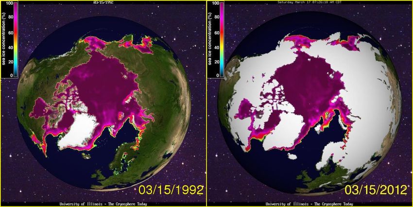
11.3 Advanced Settings ..................................................................................................................................................... 87
 11.3.1 Speed Variables: ................................................................................................................................................ 87

 CONTENTS
 11.3.2 Ordinary Vessel Cost Components:...................................................................................................................... 88
 11.3.3 Ice Reinforced Vessel Cost Components:............................................................................................................. 88
12 References......................................................................................................................................................................... 89

Figure List

Figure 2.1: The Arctic Shipping Routes ........................................................................................................................................... 11
Figure 2.2: Search and rescue coordination areas in the eastern section of the NSR ........................................................................ 12
Figure 2.3: Global shipping choke points ........................................................................................................................................ 13
Figure 3.1: September sea ice concentration in 1987 and 2012 ...................................................................................................... 23
Figure 3.2: March sea ice concentration in 1987 and 2012. ............................................................................................................ 23
Figure 3.3: Projected Arctic sea ice concentration in 2080-2100..................................................................................................... 24
Figure 3.4: Projected Arctic shipping lanes from 2040 to 2059 ........................................................................................................ 25
Figure 4.1: Major container ports in East Asia that are within reach of the Arctic Routes ................................................................ 29
Figure 5.1: The version of the Northern Sea Route examined in this study ....................................................................................... 34
Figure 5.2: Voyage distances and port visits along the Northern Sea Route and Suez Canal Route .................................................... 35
Figure 5.3: Size comparison of Arcticmax and large open water vessels .......................................................................................... 36
Figure 5.4: Length of the navigation season along the NSR from the Kara Strait to the Behring Strait ............................................... 39
Figure 5.5: Annual number of successful voyages........................................................................................................................... 41
Figure 5.6: EIA residual fuel oil price projections ............................................................................................................................ 42
Figure 5.7:Voyage cost component breakdown .............................................................................................................................. 47
Figure 5.8: Total cost component breakdown for the 8000 TEU open water vessel .......................................................................... 50
Figure 5.9: Total cost component breakdown for the 8000 TEU ice reinforced vessel ...................................................................... 50
Figure 5.10: Cost per TEU ratio in the low navigation scenario ........................................................................................................ 52
Figure 5.11: Cost per TEU ratio in the high navigation scenario ....................................................................................................... 52
Figure 5.12: Voyage cost component breakdown when super slow steaming on the NSR ................................................................ 53
Figure 5.13: Cost per TEU ratio with a voyage speed of 15 knots along the NSR .............................................................................. 54
Figure 5.14: Cost per TEU ratio with a voyage speed of 12 knots along the NSR .............................................................................. 54
Figure 6.1: Projected sources of gas supply by region in 2035 ........................................................................................................ 62
Figure 6.2: Projected global LNG demand by region ........................................................................................................................ 63
Figure 7.1: Number of passengers, crew and visits by cruise ships in Svalbard (1997 – 2012)........................................................... 68
Figure 7.2: Cruise shipping passengers visiting Greenland (2003 – 2013) ......................................................................................... 69
Figure 7.3: Annual number of voyages and vessels operating in the Canadian Arctic ........................................................................ 69
Figure 9.1: Structure of the Arctic Council ..................................................................................................................................... 77
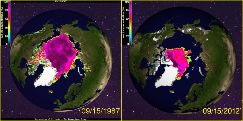
Figure 9.2: Arctic Marine Shipping Assessment .............................................................................................................................. 78
 Figure 10.1: Cost per TEU ratio for the 10000 TEU vessel in the low warming scenario .................................................................... 80
ARCTIC SHIPPING – COMMERCIAL OPPORTUNITIES AND CHALLENGES

 Figure 10.2: Cost per TEU ratio for the 10000 TEU vessel ratio in the high warming scenario ........................................................... 81
 Figure 10.3: Cost per TEU ratio for the 15000 TEU vessel in the low warming scenario .................................................................... 81
 Figure 10.4: Cost per TEU ratio for the 15000 TEU vessel in the high warming scenario ................................................................... 82
 Figure 11.1: Calculation tool front page ......................................................................................................................................... 83
 Figure 11.2: Calculation tool results page ...................................................................................................................................... 84
 Figure 11.3: Calculation tool advanced settings page ..................................................................................................................... 87

 Table List
 Table 2.1: National and multinational reasearch projects on Arctic shipping .................................................................................... 17
 Table 2.2: Review of economic studies on the feasibility of Arctic transport.................................................................................... 18
 Table 4.1: Distance savings of the NSR as an alternative to the SCR between North Western Europe and Asian ports........................ 27
 Table 4.2: Distance savings of the NWP as an alternative to the SCR between North Western Europe and Asian ports ...................... 27
 Table 4.3: Distance savings of the NWP as an alternative to the PCR between East Coast USA and Asian ports ................................. 28
 Table 5.1: Vessel dimensions and building costs............................................................................................................................. 37
 Table 5.2: Past observations of the annual number of ice free days along the Marginal Seas of the Arctic Ocean .............................. 38
 Table 5.3: Vessel navigation speed and fuel consumption ............................................................................................................... 44
EXECUTIVE SUMMARY 7

 EXECUTIVE SUMMARY
Over the last few decades the Arctic Ocean has the past, present and future. This provides a holistic
experienced a rapid reduction in both the extent and overview of how the Arctic regimes are interlinked and
volume of sea ice. These changes, caused by the global thus creates the regulatory space, which companies operate
temperature increases, have opened up previously within.
inaccessible shipping lanes and made possible the
extraction of major natural reserves of fossil fuels. The findings of the report conclude that major
Following these changes in the Arctic environment, the opportunities for the maritime sector exist if the ice cover
last decade has seen an influx of maritime activities in the on the Arctic Ocean continues to decline. The sector of dry
segments of liquid bulk shipping, offshoring and cruise bulk and offshoring are currently the sectors with the
tourism. The Arctic is one of the last frontiers on our largest potential as the Arctic hosts and abundance of the
planet and consequently the need to shed light on marine natural resource. The results from the quantitative study
activities in and around the Arctic Ocean has arisen. The on the feasibility of liner shipping across the NSR indicate
aim of this study is to address and analyze some of these that Arctic liner shipping may become economically
challenges and opportunities in the spheres of both the feasible around 2040, if the ice cover continues to diminish
private and public sector. at the present rate. The possibility of a major expansion of
On the industry level previous and ongoing projects are the maritime activities within the sectors of bulk,
mapped out for each of the four major maritime sectors. offshoring and liner shipping before midcentury rests upon
This involves liner shipping, bulk shipping, offshoring and several crucial assumptions which are all subject to major
cruise tourism. Additionally the possibilities and uncertainties. These uncertainties include the hazardous
challenges are analyzed qualitatively, with a particular environmental conditions, port and infrastructure
focus on the future prospects for each of these four sectors, availability and high costs of operation compared to the
from a combination of past literature and economic theory. southern shipping lanes. Additionally the Arctic Ocean
As a part of the chapter on the opportunities for the liner lacks an international governmental and regulative
shipping sector in the Arctic a quantitative economic framework in combination with high entry costs creates
analysis is performed. The aim of the quantitative analysis uncertainty for the maritime industry seeking to operate in
is to examine the economic feasibility of transporting and around the Arctic Ocean.
containerized goods using the Northern Sea Route (NSR)
between Northern Europe and East Asia as an alternative The calculations presented in the liner shipping
to the Suez Canal Route (SCR). More specifically the quantitative study, are based on a calculation tool
study will aim to determine when (if ever) the investment specifically designed to support the conclusions of the case
in an ice-reinforced container ship operating along the study. This calculation tool, available for download along
NSR would be preferable to an investment in an open with the report, allows researchers and industry
water vessel solely navigating the SCR. professionals to insert the specifications of a given vessel,
 along with environmental and economic parameters in
Finally this report presents a descriptive analysis of the order to obtain information on the feasibility of
political and regulative environment is executed, with an transporting containerized cargo along the NSR.
emphasis on how the regulatory environment is created. Specifically, the model allows the user to determine the
The aim is to facilitate how these political and regulative year when the investment in an ice reinforced
institutions impact the future prospects for maritime containership operating along the NSR during the
activities in the Arctic. The analysis will investigate navigation (and the SCR at other times), will become
international cooperation and unilateral standards, focusing favorable compared to an ordinary container ship solely
on how each of these scenarios affects regional stability. operating on the SCR.
This is performed in a theoretical framework incorporating
8
 1 INTRODUCTION
ARCTIC SHIPPING – COMMERCIAL OPPORTUNITIES AND CHALLENGES

 This report forms part of the ambitious CBS Maritime 4. How will current and future regulative regimes
 research initiative entitled “Competitive Challenges and impact the maritime industry operating in the
 Strategic Development Potential in Global Maritime Arctic?
 Industries” which was launched with the generous support 5. What are the underlying intentions of the Arctic
 governmental bodies?
 of the Danish Maritime Fund. The competitiveness
 6. Are the Arctic governmental bodies heading
 initiative targets specific maritime industries (including
 towards more cooperation?
 shipping, offshore energy, ports, and maritime service and
 7. How will the governmental bodies impact the
 equipment suppliers) as well as addresses topics that cut
 maritime industry operating in the Arctic?
 across maritime industries (regulation and 8. What are the opportunities for Danish maritime
 competitiveness). The topics and narrower research companies and sub suppliers in the Arctic?
 questions addressed in the initiative were developed in
 close dialogue between CBS Maritime and the maritime 1.2 READERS GUIDE
 industries in Denmark.
 The report is divided into nine parts with the first part
 containing the summary, acknowledgements and research
 CBS Maritime is a Business in Society (BiS) Platform at
 questions. The second part introduces the shipping lanes of
 Copenhagen Business School committed to the big
 the Arctic Ocean and the maritime challenges as well as
 question of how to achieve economic and social progress
 possibilities created by climate changes in the region. Part
 in the maritime industries. CBS Maritime aims to
 three presents the newest research on the impact of climate
 strengthen a maritime focus at CBS and create the
 change in the Arctic Ocean and aims to give an estimate
 foundation for CBS as a stronger partner for the maritime
 on the pace at which the Arctic sea ice is melting. In part
 industries, as well as for other universities and business
 four, the possibilities and challenges for liner shipping in
 school with a devotion to maritime economics research.
 the Arctic are presented. Chapter five continues in the
 The competitiveness initiative comprises a number of PhD
 subject of liner shipping by presenting a quantitative study
 projects and five short term mapping projects, the latter
 aiming to determine when shipping along the Northern Sea
 aiming at developing key concepts and building up a basic
 Route may become feasible compared to the Suez Canal
 industry knowledge base for further development of CBS
 Route on the Europe to Asia trade.
 Maritime research and teaching.
 Part six analyses the possibilities and challenges for the
 dry and liquid bulk sector and presents current and future
 This report attempts to map the opportunities and
 resource extraction activities in the Arctic of relevance to
 challenges for the maritime industry in an increasingly
 the maritime industry. The seventh part analyses the
 accessible Arctic Ocean.
 possibilities and challenges for the cruise shipping sector
 in the Arctic while the seventh part gives a brief
 1.1 RESEARCH QUESTIONS: presentation of the opportunities for the Danish maritime
 industry in an increasing accessible Arctic Ocean. Finally
 1. What are the major challenges to an increase in the ninth and last part presents the political environment of
 maritime activity in the Arctic? the Arctic, mapping the relevant institutions and their
 2. What are the major opportunities for the maritime regulatory power, to understand future trajectories.
 industry segments of liner shipping, bulk,
 offshoring and cruise ship tourism?
 3. Will the Northern Sea Route become competitive
 compared to the Suez Canal Route on the Europe
 to East Asia trade?

1.3 ABBREVIATIONS 9

 INTRODUCTION
NSR: Northern Sea Route
SCR: Suez Canal Route
NWP: North West Passage
TSR: Transpolar Sea Route
PCR: Panama Canal Route
IMO: International Maritime Organization
CCG: Canadian Coast Guard
NSRA: Northern Sea Route Administration
TEU: Twenty Foot Equivalent
NM: Nautical Miles
SAR: Search and Rescue
IPCC: International Panel on Climate Change
DWT: Dead Weight Ton
GCM: General Circulation Model

Source: Scanpix / Iris
10
 2 THE ARCTIC – A NEW REGION FOR
ARCTIC SHIPPING – COMMERCIAL OPPORTUNITIES AND CHALLENGES

 MARITIME EXPANSION?
 GLOBAL WARMING HAS OPENED UP NEW SHIPPING ROUTES IN THE ARCTIC PRESENTING A
 NEW FRONTIER FOR MARITIME ACTIVITIES. ESPECIALLY THE NORTHERN SEA ROUTE AND
 THE NORTH WEST PASSAGE HAVE THE POTENTIAL TO SERVE AS MARITIME SHORTCUTS
 BETWEEN THE WORLDS ECONOMIC CENTERS. UNDERDEVELOPED AND REMOTE THESE
 ROUTES PRESENTS MAJOR CHALLENGES FOR TRANSITING VESSELS AND ICE CONDITIONS
 STILL POSE A THREAT TO EVEN THE STRONGEST ICEBREAKERS.
 The Arctic Ocean‘s sea ice is melting at a rapid pace, North America, although the waters of Greenland also
 leaving an ever larger section of the polar seas ice-free provide significant possibilities for the sector. The
 each summer. The six years with the lowest observed Northern Sea Route (NSR), which runs along the Russian
 summer sea ice extent have all occurred within the last Arctic coast, is currently the most well developed, and has
 decade (Smith & Stephenson, 2013). And new forecast consequently seen the most extensive utilization. The
 models are continuously bringing forward expectations of North West Passage (NWP) in the Arctic Canada has seen
 ice-free summers in the Arctic (Flake, 2013) creating a limited development and maritime traffic. The next two
 significant potential for previously impossible maritime chapters will present the opportunities, infrastructure and
 activities. The diminishing ice cover has not only allowed geography of both shipping routes along with their
 for the utilization of the Arctic shipping lanes for surrounding areas while. The last chapter will focus on the
 intercontinental transport, but has also resulted in vast numerous challenges facing maritime operations in the
 quantities of natural resources such as oil, gas and minerals remote Arctic.
 to be extractible. This creates opportunities for various
 sectors of the maritime industry within: transport,
 offshoring, servicing, emergency response, surveillance,
 2.1 THE NORTHERN SEA ROUTE
 The NSR is the shipping route connecting Europe and
 maritime equipment, new build and retrofitting vessels.
 Asia, north of the Eurasian landmass. The NSR has the
 The vast and remote Arctic Ocean entails significant
 challenges and hazards to companies seeking to operate in potential to reduce the distance between Europe and Asia
 this environment. These challenges include first and by up to 40 per cent, compared to the contemporary Suez
 foremost the cyclical ice cover and the drift ice this Canal Route (SCR). The NSR is not a specific route but a
 creates. However, the lack of population centers, suitable multitude of passageways along the Russian Arctic and
 ports and the lack of developed infrastructure for search therefore covers a vast segment of the Arctic Ocean
 and rescue (SAR), poses even larger operational and (Kronbak & Liu, 2010). The coastal versions of the NSR
 environmental risks. Further, the need for ice reinforced are currently the most trafficked, running along the
 vessels and specialized equipment impose significant Russian Arctic coast. From west to east, the route traverses
 investment costs needed to maintain maritime activities in the five marginal seas of the Barents Sea, the Kara Sea, the
 the high Arctic. Currently only a limited number of Laptev Sea, the East Siberian Sea and the Chukchi Sea,
 companies are operating in the region, of which the until reaching the Behring Strait between Siberia and
 majority of these are present in the Northern part of the Alaska. Although the opening of the NSR has mainly been
 Eurasian landmass. connected to the shipment of goods between Europe and
 Although accessibility for maritime activities has increased
 East Asia, vast quantities of proven oil, gas and mineral
 in the Arctic, the central part of the Arctic Ocean is still
 reserves are situated along the route. This creates a diverse
 covered in ice throughout most of the year. The
 range of opportunities for both the offshore, bulk and
 possibilities for the maritime industry are mainly divided
 tanker sectors. The combination of
 into the two coastal regions of Arctic: Eurasia and arctic
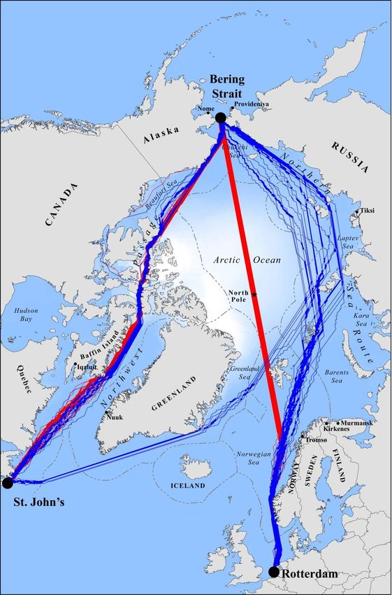
11

 THE ARCTIC – A NEW REGION FOR MARITIME EXPANSION?
Figure 2.1: The Arctic Shipping Routes
Source: Humpert & Raspotnik (2012)

transport and resource extraction opportunities has sparked Strait. The Kara Gate, separating Novaya Zemlya from the
an influx of maritime activities in the waters of the NSR. Russian mainland, has a minimum depth of 21 meters
In 2012 a total of 46 vessels operated along the route while the De Long Strait, south of Wrangel Island, has a
carrying a total cargo volume of almost 4 million tons of 20 meter restriction. The most severe draft restriction is
cargo. The number of commercial vessels operating on the encountered in the Sannikov Strait, between the New
route in 2013 increased to 71 vessels, with close to 30 of Siberian Islands archipelago, being only 13 meters deep.
them transiting the entire route between Europe and the Navigating the Sannikov Strait therefore limits passing
Pacific and some of the vessels yielding 60,000 gross tons vessels to only 100,000 DWT or 4,500 Twenty-foot
or more. In 2014, however, the traffic declined to 53 Equivalent Units (TEU) which is significantly less than a
transits, and data concerning the fraction of these vessels large section of the merchant vessels traversing the Suez
that navigated between Europe and Asia are currently Canal (Humpert, 2014). In order to bypass the shallow
unavailable (NSRA, 2015). straits along the Russian Arctic coast it is possible to
 navigate along a more northern route passing over Novaya
The coastal waters are generally shallow at a depth of less Zemlya, The New Siberian Islands and Wrangel Island.
than 100 meters and the different marginal seas are While allowing for vessels of far greater sizes, the more
separated by narrow straits, which are occasionally northern routes run periphery to the Arctic Basin. These
blocked by pack ice. Some of these straits also present routes are therefore subject to more severe ice conditions
draft restrictions on vessels navigating, the most severe but reduce the distance between Europe and Asia. Even
being the Kara Gate, the Sannikov Strait and the De Long though a vessel may aim at predetermined course of the
12
ARCTIC SHIPPING – COMMERCIAL OPPORTUNITIES AND CHALLENGES

 Figure 2.2: Search and rescue coordination areas in the eastern section of the NSR
 Source: Gosmorspassluzhba (2013)

 coastal or northern route, the ice conditions in the Arctic cover forecasts, and from this determines the necessity for
 may force the shippers to alternate the route several times icebreaker assistance along the planned route, given the ice
 and the length of the Northern Sea Route therefore varies classification of the vessel traversing the NSR. The NSRA
 between 2,200 and 2,900 nautical miles (Østreng, et al., has established requirements of the ice strengthening
 2013, p. 13). The waters along the NSR between the Kara capabilities of vessels navigation the NSR given the
 Gate to Cape Dezhnev is administered by the Russian navigation season and general ice conditions at the time.
 Federal institution “Administration of the Northern Sea To illustrate, it is allowed for a light ice reinforced vessel,
 Route” (NSRA) with the main targets of “…ensuring safe class ICE3, to independently navigate the entire NSR in
 navigation and protection of marine environment from the mild ice conditions during the period August to November
 pollution in the water area of the Northern sea route” 1st. However, in case of medium ice conditions, a
 (NSRA, 2015). minimum of class polar class 6 (Arc6) is required for
 vessels. Further, the Russian Federal Tariff Service
 The NSRA manages the Russian icebreaker fleet, which is recently announced an updated icebreaker tariff scheme
 currently the largest in the world1, and evaluates if for foreign vessels navigating the NSR coming into effect
 icebreaker escort is needed and also administers fees by 21 April 2014. Compared to the previous system this
 related to icebreaker escort service for vessels traversing new tariff scheme presents an increased transparency of
 the NSR. The NSRA provides short and long term ice the system, lowering of the official price level, which
 makes cost projections of navigating the NSR more
 1
 The fleet includes seven nuclear powered and multiple accurate for operators. This updated icebreaker escort tariff
 conventional ice breakers.
13 THE ARCTIC – A NEW REGION FOR MARITIME EXPANSION? Figure 2.3: Global shipping choke points Source: The Arctic Institute is determined based on the following four voyage smaller settlements with a moderate level of port facilities specifications: include Sabetta on the Yamal Peninsula, Tiksi at the Kara Sea and Pevek located near the New Siberian Islands. The Total gross ton of the vessel seeking passage infrastructure for SAR along the NSR has expanded in the The ice classification of the vessel last few years with two marine rescue operations The season where the passage is to occur headquarters located in Murmansk and Vladivostok. The The areas where icebreaker assistance is needed operations headquarters in Murmansk is based on the federal state enterprise RosAtomflot, while the The base fee increases with the number of zones where headquarters in Vladivostok is based on the Far Eastern icebreaker assistance is provided but is not directly Shipping Company. The SAR and the oil spill response affected by the lengths or time of the received escort assets along the NSR are managed in collaboration by with service. This implies that the icebreaker assistance fee will the headquarters by two marine rescue coordination remain the same regardless of receiving icebreaker centers and several marine rescue sub centers. The two assistance for 10 or 500 nautical miles within the of the marine rescue coordination centers are located in zone along the NSR. Additionally the tariff fee only Murmansk and Dikson, while the sub centers are located in applies when actually receiving icebreaker escort, creating Archangelsk, Tiksi, Pevek and Port Provideniya. However, the potential for ice-reinforced merchant vessels to these centers are still separated by vast distances and the completely avoid transit fees in mild ice conditions. response time may easily be inadequate to prevent Previously the tariff was mandatory regardless of receiving fatalities in case of an emergency. Although the icebreaker assistance or not, and it remains to be seen infrastructure and traffic is scarce, the Russian Federation whether such a mandatory fee still applies. Russia has the authorities have continuously emphasized that the NSR most developed coastline infrastructures in the high Arctic, holds a great potential as a major international shipping although the average distance between ports and SAR lane, initiating several programs to further improve upon centers measures about 2000 kilometers. By far the largest the current infrastructure and port facilities (Arctic port in the Russian Arctic is the port of Murmansk located Council, 2009). on the Kola Peninsula, accessible throughout the entire year due to the Atlantic thermohaline current. Other
14 2.2 THE NORTH WEST PASSAGE NWP, causing the navigation season to be less stable than
 that of the NSR.
 The NWP is defined as the combination of shipping lanes
ARCTIC SHIPPING – COMMERCIAL OPPORTUNITIES AND CHALLENGES

 connecting the Atlantic Ocean with the Pacific Ocean Shipping in the Canadian Arctic is governed by the
 through the North American Arctic waterways. From east Canadian Coast Guard (CCG), which monitors vessel
 to west, the NWP passes through the Davies Strait, Baffin movements and provides radio services. Importantly ice
 Bay and through the Canadian Arctic Archipelago to the and weather information is provided for vessels operating
 Beaufort Sea. This then leads to the Chukchi Sea, finally along the NWP through the NORDREG system. The CCG
 opening up to the Pacific Ocean through the Behring has divided the Canadian Arctic into various zones, where
 Strait. In addition to holding vast reserves of minerals and navigation is allowed depending on sufficient ice
 petrochemicals, the waterways of the NWP has the strengthening capabilities of vessels. (CCG, 2012).
 potential to function both as an alternative to the Suez Compared to the Russian Arctic the areas along the NWP
 Canal and the Panama Canal. Potentially the distance are extremely underdeveloped – especially around the
 between Northwestern Europe and Asia can be reduced by waterways of the Canadian Arctic. The largest and only
 up to 30 per cent, as well as up to 20 percent between East well-developed port in the Canadian Arctic is Churchill,
 Coast USA and East Asia. This Archipelago is a complex located in Hudson Bay close to the interior of the North
 geographic area consisting of 36.000 islands spanning an American continent. The Hudson Bay shipping season
 area of 2.1 million square kilometers (Arctic Council, lasts from mid-July to the beginning of November but the
 2009). In similarity to the NSR, is not a specific route but a season could be lengthened significantly with the use of
 combination of several routes due to the multitude of icebreaker support (Arctic Council, 2009).
 different straits and waterways. Overall these routes follow
 a northern path through the Parry Channel, or a southern Directly along the NWP lies Port Resolute, situated in the
 path passing south of Victoria Island. The northern route is middle of the Archipelago on the banks of Cornwallis
 relatively deep allowing for navigation of large sized Island near the Barrow Strait. The Canadian Army has
 vessels. These routes are subject to severe ice conditions, recently expanded the facilities at Resolute to enable the
 even during the summer, posing a navigational risk. The base to serve as a command post for SAR and disaster
 southern route can be used to mitigate this risk, as the response operations (CAF, 2013). The port of Resolute is
 Coronation Strait South of Victoria Island is better unsuited to accommodate vessels with a draft of more than
 shielded from drift ice. On the other hand, this strait is 6 meters, but the Canadian Navy is currently constructing
 extremely shallow and only allows for the passing of a deep water naval facility at Nanisivik, near the eastern
 vessels with a draft of less than 10 meters. entrance of the NWP, projected to become operational by
 The ice conditions in the Canadian Arctic are generally 2018 (Sun, 2015).
 more severe than those along the NSR, and the straits Port facilities along the North American Arctic coast west
 remains frozen for a longer period throughout the year. of the passages are equally negligible. The closest well
 Global warming has caused a reduction in the ice cover in developed infrastructure is the west coast of Greenland,
 the Canadian Arctic, the extent of summer sea-ice is Nuuk being the largest and most significant port. The CCG
 volatile and several of the straits may still experience currently maintains and icebreaker fleet of 17 vessels, six
 severe ice conditions even during summer. This was assigned to the Canadian North during the summer
 evident in 2007 most of the NWP waterways were months. During the navigation season the CCG states it
 completely ice free, while ice conditions in the following has an average response time along the NWP of 10 hours,
 year were far more severe. In 2008 several of the Straits under average ice conditions (CCG, 2013). Even though
 were covered in ice during most of the navigation season. the CCG icebreaker fleet hosts a significant number of
 During the summer months the Arctic Ocean current vessels, it is ageing with several of the vessels nearing
 forces multiyear ice from the North Pole to drift into the retirement age. The Canadian Government has recently
 NWP straits. This frequently clogs the straits, presenting a announced the investment of $CAD 720 million to replace
 risk to all but the strongest icebreaking vessels operating the aging icebreaker flagship CCGS Louis S. St. Laurent
 along the NWP (Arctic Council, 2009). Because of the but more funding is needed to maintain a significantly
 North Pole being covered in ice throughout the entire year large fleet of icebreakers in the future (Arctic Council,
 - and will remain so in a foreseeable future - such flows of 2009). Lastly, further development of maritime activities
 multiyear ice will continue to drift into the straits of the in the Canadian Arctic is hampered by Canadian
 legislation, as it provides an inadequate framework for
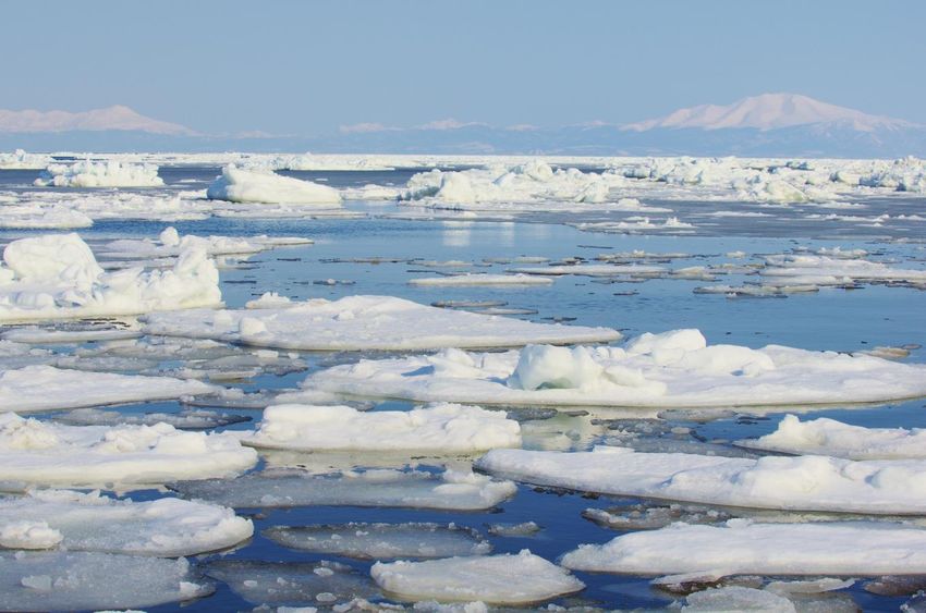
transiting vessels. This results in uncertainties for the minimizes the risk of getting trapped in a sudden freeze 15
maritime sector investing in the NWP (NIRAS, 2014). during autumn. In the future, an ice free September Ocean

 THE ARCTIC – A NEW REGION FOR MARITIME EXPANSION?
 will remove the presence of the thick multiyear ice;
2.3 ARCTIC SHIPPING CHALLENGES reducing risks even further (Arctic Council, 2009). The
Although the opening of the Arctic Ocean has created a winter season ice cover is not expected to disappear in a
vast number of opportunities for the maritime industry, the foreseeable future, and navigation during the winter
remote and hostile Arctic Ocean still presents several months will therefore not be possible. Summer weather in
major challenges for the industry. Some of these the Arctic is generally characterized by mild currents and
challenges include hazardous ice conditions, sub-zero wind conditions yet the weather patterns change during the
temperatures and the lack of general maritime autumn and winter with more severe conditions. More
infrastructure. Further, an increase in maritime activities in severe virulent wind systems appear3 and temperatures
the Arctic may adversely affect the sensitive environment, often descending to -50 degrees, causing sea sprays to
with oil spills being a major threat to the biodiversity of instantly freeze on vessels (Arctic Council, 2009). The
the Arctic Ocean. Arctic Ocean is a hazardous operational environment for
There is a general consensus amongst researchers that the vessels and crews alike due to shallow unmapped seas
continuing reduction in the sea ice cover volume and area along the continental coasts, low Arctic temperature, risks
will continue to diminish in the future and that an ice free of encountering drift ice formations and the shrouded in
Ocean during September will appear somewhere within darkness of the ocean for close to six months of the year.
this century2. This dramatic decline in the ice cover There is therefore a particular need for an expansion of
provides the basis for an increase in maritime activities in shore side infrastructure for SAR operations as well as
the Arctic, as seasonal ice cover variations creates a deep water ports, providing repair and refueling services
fluctuating amount of possible navigation days and (Arctic Council, 2009). At present, infrastructure for SAR

Source: Scanpix / Iris

2 3
 For more information regarding the future decline of ice These powerful weather systems are known as Arctic
cover see chapter 3 Lows.
16 is severely underdeveloped in large regions of the Arctic
 Ocean and the nearest assets may easily be located more
 lack of infrastructure, cleaning up oil spills poses a major
 operational risk (ACIA, 2004).
ARCTIC SHIPPING – COMMERCIAL OPPORTUNITIES AND CHALLENGES

 than a thousand kilometers away from potential With the changing environmental conditions, and the
 emergencies. The combination of slow speed of ships and challenges facing maximizing utilization of the Arctic, it is
 the vast distances between facilities, results in a non- paramount to recognize the emergence of relevant
 sufficient coverage to reach a distressed vessel. On top of legislation regulating the Arctic waterways and resources.
 this there is a general the lack of equipment: aircrafts, National legislation regulates many aspects, as states
 icebreakers and patrol vessels. In order to accommodate themselves create standards for operations given the local
 SAR operations as well as general escort operations conditions and priorities. This is an encumbrance for
 through ice infested waters, the fleet of ships with a strong stakeholders in the Arctic, as they potentially operate
 ice breaking classification needs to be expanded. Adding within several national jurisdictions, thus making
 to the expansion, both the Canadian and Russian fleet are compliance with different national standards complex. Due
 aging, requiring a general renewal of the fleets. to this complexity, the report seeks to provide an
 Technological infrastructure development is likewise also investigation into the multi-national governance structures
 in need of heavy investment, for understanding local in the Arctic (see part 8). These structures are important to
 conditions and satellite communication. Given the sparse understand, as these forums are potentially able to
 SAR capabilities better mapping of the ocean floor will harmonize practices and create the best conditions for
 provide safer transit of vessels, reducing the risk of Arctic stakeholders. Findings by Arctic Marine Shipping
 groundings. To further reduce risk of ice and groundings, Assessment in 2009 indicate that multilateral-governance
 it is necessary to obtain better tools for forecasting ice will provide the best regulatory framework as this allows
 movement, weather conditions and ocean currents. In coordination between national entities. This coordination
 providing this information, satellite communication allows for the best protection of environmental concerns,
 systems are also inadequate. This is used for vessels because economic resources are better allocated (Arctic
 maintaining contact with the relevant authorities and vice Council, 2009).
 versa, but is however unavailable in large parts of the high As with the emergence of landmasses, as the ice retreats,
 Arctic. As the number of vessels operating in the Arctic these multi-national organizations obtain certain broker
 increases, so does the risk of accidents and places pressure positions within the Arctic community. In this framework
 on the limited amount of infrastructure. Therefore the high the Arctic Council is important as the dominant state level
 Arctic coastal states have to carry out heavy investments, forum for policy development and coordination. Based on
 to provide a safer operational environment for its a notion of applying the best science, the forum aims to
 stakeholders. create harmonized operational standards, optimal
 The increase in maritime activities in the Arctic Ocean conditions for the development of local populations and to
 also provides a challenge to preserve the pristine and ensure environmental protection. Focusing on the political
 previously touched Arctic environment. Emissions from tensions, the United Nations Law of the Sea is similarly
 the engines of shipping, adversely affecting the important being the only internationally recognized
 environment, include carbon dioxide (CO2,) Nitrogen mechanism for defining the territorial boundaries.
 oxide (NOx), Sulphur Oxide (SOx) and black carbon. Growing economic interest in the regions natural
 Although these emissions are a product of shipping in all resources, and the derived potential for benefits to the
 the World’s oceans, black carbon darkens the surface of Arctic states, has increased the importance on how natural
 the ice-cover in the Arctic Ocean reducing the amount of subsea structures define territorial boundaries. The
 sunlight reflected by the ice. Such a reduction in the overlaying and conflicting claims between states, have led
 reflection of the sun light (albedo) further increases to some tensions in the political positioning. The disputes
 melting and therefore enhances the already significant will however not present a substantial challenge for the
 effects of global warming in the Arctic. Major oil pollution Arctic cooperation; as there is a high level of
 also has the potential to destroy Arctic environment. The interdependency between the states in the long run.
 1989 Exxon Valdez oil spill in Prince Williams Sound
 Alaska, inflicted major damage to the environment with an 2.3.1 Past studies on Arctic Shipping
 estimated quarter of a million bird deaths. Fourteen years The collapse of the Soviet Union in 1991 led to the
 after the Exxon Valdez accident, oil was still found around subsequent opening of the Russian Arctic to foreign
 Price Williams Sound. Due to the hostile climate and the traffic. This produced a multitude of studies on the
Project Time Span Research Area Participants
 17
 INSROP 1993-1999 The Northern Sea Route Japan, Norway and Russia

 THE ARCTIC – A NEW REGION FOR MARITIME EXPANSION?
 Ice Routes – The Application of
 Advanced Technologies to the Routing Ship efficiency in ice
 of Ships through Sea Ice 1997-1998 covered waters European Union
 ARCDEV – Arctic Demonstration and
 Exploratory Voyages (1997-1999) 1997-1999 Western Arctic Seas European Union
 ARCOP – Arctic Operational Platform
 (2002-2006) 2002-2006 The Northern Sea Route Russia and Norway
 Barents, Kara and North European Union, Norway and
Northern Maritime Corridor (2000-2005) 2000-2005 Seas Russia
 JANSROP (2002-2005) 2002-2005 The Northern Sea Route Japan
 Canadian Arctic Shipping Assessment
 (2005-2007) 2005-2007 Canadian Arctic Waters Canada
 AMSA – Arctic Maritime Shipping
 Assessment (2009) 2006-2008 The Whole Arctic The Arctic Council
Table 2.1: National and multinational reasearch projects on Arctic shipping

possibilities of commercial activities in the Arctic. The and the subsequent changes in the underlying assumptions
rapid decline of the ice cover observed during the last of papers published prior to the change of the millennium 4.
decade, has increased the frequency of such studies as the
probability of large scale maritime activities became more
realistic.
These studies range from academic papers, books and
commercial reports to large multilateral research programs
aiming to assess the feasibility of maritime traffic in the
increasingly ice free Arctic Ocean. These large research
programs, listed in table 2.1, mainly explore the technical,
environmental, infrastructure and political aspects, and do
not have a focus on economic analyses and are therefore
not further reviewed in this chapter.

In recent years, the focus of papers on Arctic shipping has
changed to a micro economic foundation of quantitative
studies on the feasibility of specific operations. The
framework behind these studies varies between liner and
bulk shipping, with both the feasibility of using NWP and
the NSR as alternatives to the southern shipping lanes of
the SCR and Panama Canal Route (PCR).
A brief review of recent studies on the economic
feasibility of utilizing the Arctic shipping routes for
commercial transport along with the methodology,
framework and their assumptions behind is presented in
table 2.2 below. These studies only include articles and
studies published within the last decade. This is due to the
unanticipated pace at which the Arctic sea ice is melting

 4
 For a more extensive review of recent literature on the
 feasibility of Arctic shipping routes see Lasserre (2014).
You can also read