Assessment of Pacific sand lance (Ammodytes hexapterus) and surf smelt (Hypomesus pretiosus) spawning along the Gorge Waterway, Victoria, BC ...
←
→
Page content transcription
If your browser does not render page correctly, please read the page content below
Assessment of Pacific sand lance (Ammodytes hexapterus) and surf smelt
(Hypomesus pretiosus) spawning along the Gorge Waterway, Victoria, BC.

                            March 31st, 2021
                             Molly Duncan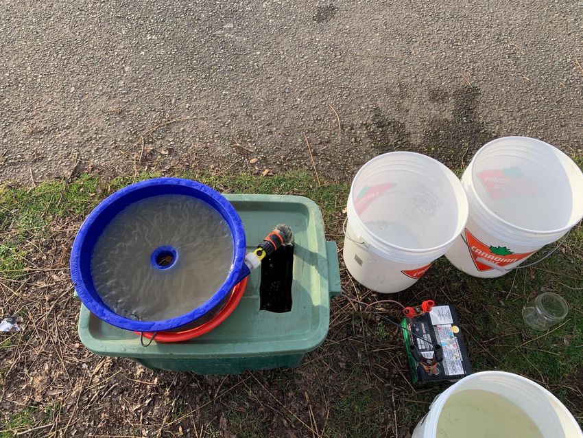
Background:
       The term forage fish is defined as highly productive, small to medium sized, bony fish
species that are an incredibly important component of a complex food web that connects
terrestrial, intertidal, inshore, and offshore habitats throughout the Pacific Northwest and
world (Keen 2014). These fish consume phytoplankton and zooplankton, but more importantly,
provide the main pathway for energy and nutrients to flow to higher trophic levels as they act
as a food source for larger fish like chinook salmon (Oncorhynchus tshawytscha) and lingcod
(Ophiodon elongatus), seabirds like great blue heron (Ardea herodias) and bald eagles
(Haliaeetus leucocephalus), and marine mammals including harbor seals (Phoca vitulina),
Steller's sea lions (Eumetopias jubatus), and humpback whales (Megaptera novaeangliae )
(Chow et al. 2020). Not only are forage fish ecologically important, but certain species, like
anchovies and herring, are targets in some of the world’s largest commercial fisheries for
human consumption, use as roe, bait and feed in aquaculture, and feed and fertilizer in
agriculture (Alder et al. 2008).
       There are a variety of forage fish species in British Columbia, two of which are Pacific
sand lance (Ammodytes hexapterus) and surf smelt (Hypomesus pretiosus). Both species live in
intertidal areas and use certain sandy-gravel beaches for egg deposition and incubation. At high
tide, the fish burrow themselves into the sand and release their eggs into these holes. These
eggs are then exposed to periods of intertidal exposure and take between 14 (surf smelt) to 28
days (Pacific sand lance) to develop (Keen 2014). Pacific sand lance typically spawn between
November to February on Vancouver Island, while surf smelt spawn all year-around (WWF
Canada 2020). Both species prefer spawning areas with intact marine riparian buffer zones,
overhanging shade vegetation, clean water, and a supply of pebbles and sand (de Graaf 2017).
Most important for spawning is the mixture of sediments that are the right size. Pacific sand
lance prefer fine-medium sediments 0.2 mm to 0.4mm in diameter, and surf smelt will spawn in
coarse sand and gravel ranging in size from 1.0 mm to 7.0 mm (Chow et al. 2020).
       Many human activities impact and alter marine shorelines, thus are a massive threat to
surf smelt and sand lance spawning beaches. One of the largest impacts to the sensitive
environment is the physical alteration of beaches, such as the building of structures like piers,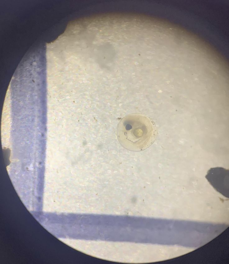
docks, breakwaters, riprap, and seawalls. These modifications alter the natural processes of
waves and alter the beach shape and sediment composition. They can even lead to adjacent
beaches being washed away (Environmental Law Centre 2019). Modifications to the shoreline
have also led to the loss of vegetation along the shorelines. The loss of overhead vegetation
that provides shading can be extremely detrimental as it increases thermal stress and
desiccation to incubating eggs as the sediment temperatures rise, thus leading to increased
mortality of eggs (Penttila 2001). The removal of backshore vegetation can also alter natural
soil erosion rates, water absorption, and nutrient flows. Lastly, climate change can have a
harmful effect on beaches both due to the rising sea levels and the way humans respond to this
threat. Changing sea levels and extreme weather events will diminish the size of the beaches
and stronger waves can lead to increased sediment erosion in the intertidal zones. Human
activity like the placement of sea walls to prevent beaches from retreating landward will only
exaggerate the effect and lead to coarser sediment and narrower beaches, greatly affecting the
upper zone of beaches where surf smelt and sand lance spawn (de Graaf 2017).
       To better protect the populations of sand lance and surf smelt, and indirectly a large
component of the marine food web, spawning sites must be identified. Both Pacific sand lance
and surf smelt have been seen in the Gorge, but knowledge on whether they spawn in the area
is unknown. The goal of this study is to act as a preliminary assessment of spawning suitability
along the Gorge Waterway, to give a better idea of what kinds of protection and restoration
efforts should be implemented to help create and maintain suitable forage fish spawning
habitats along the Gorge Waterway.

Methodology:
Site Selection
       Before any sampling can be conducted, beaches along the Gorge Waterway were
assessed to distinguish their suitability based on dominant sediment character, integrity of
uplands, and amount of spawning substrate zone shaded. Figure 1 shows the 10 sites along the
Gorge Waterway that were surveyed by foot at low tide on January 25 and 27, 2021 to examine
their suitability as forage fish spawning habitat. An additional site along Tyron Beach, North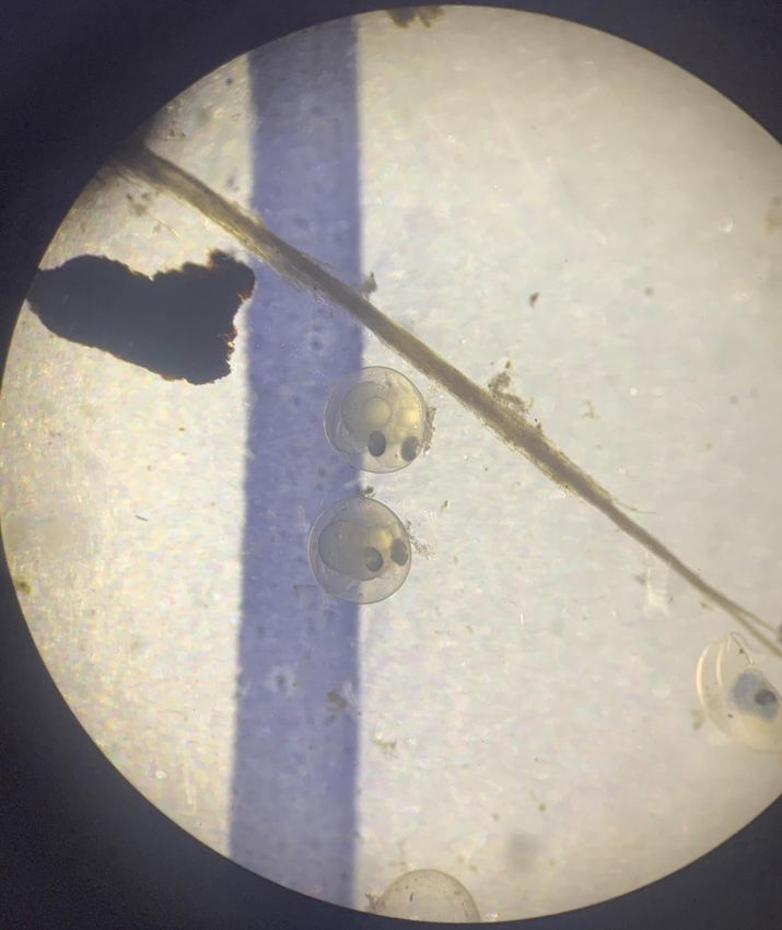
Saanich, (Figure 2) was surveyed on March 15, 2021, to serve as a positive control as forage fish
eggs had been found quite frequently during the period of this study.

Figure 1. Satellite imagery of the 10 sites along the Gorge Waterway, Victoria BC investigated
for habitat that would be suitable for Pacific sand lance and surf smelt spawning. The 10
numbers each represent the approximate location of the beaches examined. Data was
retrieved using Google Maps software.
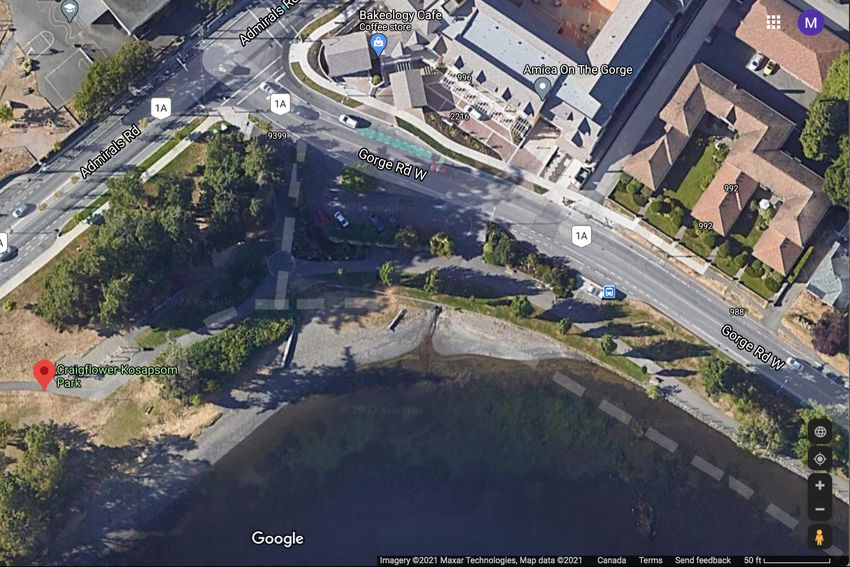
Figure 2. Satellite imagery of Tryon Beach, North Saanich, BC that was surveyed on March 15,
2021, to be used as a positive control for correct sampling technique and presence of forage
fish in the area. Data was retrieved from using Google Maps software.

Forage Fish Spawning Beach Survey Datasheet
       Following the identification of suitable sites, the Forage Fish Spawning Beach Survey
Methodology, produced by Mount Arrowsmith Biosphere Region Research Institute (MABRRI)
and Peninsula Streams Society, was used and the datasheet (Appendix A) was filled out for
each sample taken at the suitable sites once a week for a total of 5 replicates of each site. The
Location Code document (Appendix B) was used to fill out the regional district, municipality,
beach code, and Fisheries and Oceans Canada (DFO) Management Area. The last high tide and
second effective high tide was recorded based on the predicted hourly heights of Portage Inlet
(#7125) from the DFO website. The current conditions, including air temperature (°C), wind
direction, and wind speed (km/hr) were recorded based on The Weather Network app, and
water temperature (°C) was measured at each site using a thermometer. A measuring tape was
laid out to measure the width of the potential habitat, stretching from the high tide mark to five
metres towards the water, or as far as the seaward boundary. A second measuring tape of 30 m
was placed through the middle of the width line along the length of the piece to create four
equal quadrats. The coordinates were taken by GPS Camera app at the centre point of the
quadrats and recorded. The dominant beach sediment type, character of the backshore (how
impacted the area above the station is due to human development), and amount of shading
substrate were identified based on the Field Observation Sampling Codes (Appendix C). A
landmark object was chosen and the distance from the centre point to the landmark was
measured. Lastly, the type of sample (bulk or scoop) was recorded.
Sample Collection
A wide-mouth glass jar was used to scoop approximately 200 mL of the top one-two
inches of most ideal sediment and poured into a four-litre plastic container. Four more scoops
were then taken from the same quadrat and repeated in each quadrat for a total of 20 scoops
in the plastic container. A sample tag, including the date, location, sample station, and sample
number was created and placed into the plastic container for easy identification of the sample
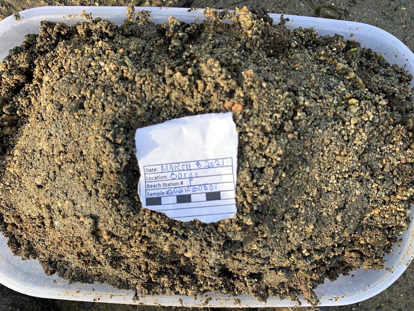
if processing was completed later (Figure 3).
Figure 3. A sample of sand possibly containing forage fish eggs. The sample tag with
date, location, sample station, and sample number was placed in 4 L bulk sample of
sand collected from one of the beaches surveyed in the Gorge Waterway near Victoria,
BC (Photo by Molly Duncan taken on March 8, 2021).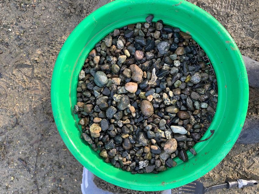
Sample Processing
       Three sieves of 4.0 mm, 2.0 mm, and 0.5 mm size were stacked from largest to smallest,
with the smallest on the bottom, and placed over a five-gallon plastic bucket. The sample that
was collected in the four-litre container was poured into the top sieve and shaken through the
sieves. Water was then poured over the sample to wash any eggs off larger rocks and pebbles
(Figure 4). Once the sample was fully washed, the sediment left in the top two sieves (4.0 mm
and 2.0 mm) can be discarded, and the sediment in the bottom sieve (0.5 mm sieve) is further
processed. Sieves were rinsed with seawater between each sample to reduce cross-
contamination among samples.

Figure 4. Photos of 4.0 mm, 2.0 mm, and 0.5 mm sieves (left to right) following the washing of
the rocks and pebbles. The material in the 4.0 mm and 2.0 mm sieve are then discarded and the
sample remaining in the 0.5 mm sieve is processed further with a vortex to separate the eggs
from the sand (Photos by Molly Duncan taken on March 8, 2021).

       Adapted from the winnowing method, the Washington Department of Fish and Wildlife
vortex method (Dionne 2015) was used to agitate and suspend the light material (including
forage fish eggs) from the heavier material. A piece of equipment commonly used for gold
panning, called the “The Blue Bowl” was converted into a vortex by connecting it to a
submersible electric bilge pump with an adjustable valve to control the water flow. The sample
collected was transferred from the 0.5 mm sieve to a plastic dish tub and the sieve was then
placed under the blue bowl gold concentrator to collect the lighter sediments. The adjustable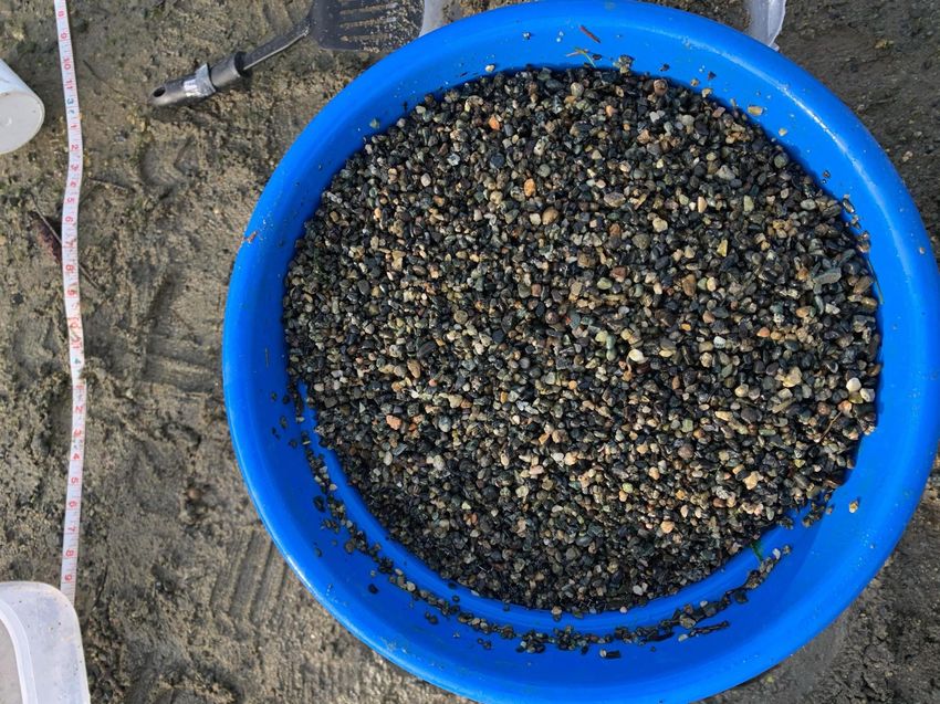
valve on the blue bowl was opened three-quarters of the way and the pump was turned on.
The sample was then slowly added to the perimeter of the blue bowl with a rubber spatula and
then stirred to further agitate the sediment (Figure 5). The 0.5 mm sieve was then removed
from under the blue bowl and the material was washed into a glass sample jar. Samples were
then stored in a refrigerator at 2.7°C for up to seven days until analysis could be conducted.

Figure 5. The vortex blue bowl system set up to separate forage fish eggs from sand. The
process begins with the sample being swirled in the blue bowl vortex. The red 0.5 mm sieve
collected all eggs and any other lighter material which float to the top of the vortex. The
contents of this sieve were then analyzed under a microscope at home (Photo by Molly Duncan
taken on March 8, 2021).

Laboratory Analysis
       A spoon was used to take approximately one teaspoon worth of sample and was then
spread thinly on a petri dish. The sample on the petri dish was then examined using an OMAX
microscope at 4X magnification (Figure 6). The first 100 embryos found were separated for
further analysis of species, number of each species, alive-to-dead ratio, and development stage
using an identification chart (Appendix D). This process was done until all of one sample was
completed, then the Petri dish was washed, and the process was repeated until the whole
sample was examined.

a)                               b)                                c)

Figure 6. a) Photo of approximately one-quarter teaspoon of vortex-reduced beach sediment
sample in a petri dish b) and c) photos of the sample under a dissecting microscope at 2X
magnification (Photos by Molly Duncan taken on March 4 and 9, 2021).

Results:
Spawning Habitat Suitability Assessment:
       Descriptions of the 10 sites sampled as potential spawning sites plus the positive control
site are summarised in Table 1. Sites as far down the Gorge Waterway as near the Selkirk
Trestle and as far up as Portage Inlet and Colquitz Creek were sampled. Figure 7 shows the
dominant sediment character of the 10 sites examined along the Gorge Waterway. The most
dominant character of sediment was pebble gravel (4.0 mm to 64.0 mm) with mud and silt base
which occurred at three of the sites assessed. Only two of the sites had pea gravel mixed with
sand, which was deemed suitable as surf smelt and sand lance spawning sites. Figure 8 shows
the location of site 3, Swim Beach at Esquimalt Gorge Park, and Figure 9 shows the location of
site 5, the beach at Craigflower-Kosapsom Park. These two sites were then surveyed for
presence of eggs.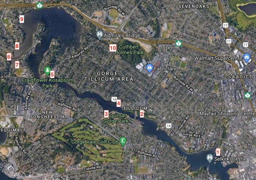
Table 1. Description of the primary assessment of 10 sites along the Gorge Waterway, Victoria,
          BC and the positive control at Tryon Beach, Victoria, BC that were examined for suitability as
          surf smelt and Pacific sand lance spawning habitat. No sites had all the preferred characteristics
          but sites 3 and 5 were evaluated as potential sites due to the mixture of small gravel and sand.
          The sites that were deemed suitable as potential spawning habitats are bolded.

Sample      Date         Beach Name       Latitude      Longitude          Description of Sediment             Potential
Station   (mm/dd/yy                                                               Character                       as
   #          )                                                                                                Spawning
                                                                                                                Habitat
  1        01/27/21         Selkirk       48.44119      -123.3805      Cobble gravel with silt and mud            No
                            Trestle                                                 base
  2        01/27/21         Saanich       48.44673     -123.39892      Pebble gravel with silt and mud            No
                          Gorge Park                                                 base
  3        01/25/21      Swim Beach       48.44680     -123.40711       Mix of pea gravel and pebble             Yes
                          (Esquimalt                                    gravel with sand and silt base
                         Gorge Park)
  4        01/25/21         Victoria     48.448599     -123.40405      Boulder and cobble gravel with             No
                          Canoe and                                              silt base
                          Kayak Club
  5        01/25/21      Craigflower-     48.55288     -123.42030      Pea gravel with mix of sand and           Yes
                          Kosapsom                                                silt base
                              Park
  6        01/25/21      Craigflower      48.45636     -123.43245                Silt and mud                     No
                             Creek
  7        01/25/21        Shoreline      48.45409     -123.42852       Silt and mud base with cobble             No
                         Community                                             and boulder gravel
                            Middle
                             School
  8        01/25/21       Helmcken        48.45887     -123.43002       Pea, pebble, and cobble gravel            No
                          Centennial                                        with silt and mud base
                              Park
  9        01/27/21         Hospital      48.46196     -123.42758       Pea, pebble, and cobble gravel            No
                             Creek                                          with silt and mud base
  10       01/25/21         Colquitz      48.2731       -123.2428       Boulder gravel with mud base              No
                          Creek Tidal
                              Shelf
  11      03/15/2021     Tyron Beach      48.67541     -123.40874      Pebble gravel with sandy base             Yes
Figure 7. Dominant sediment character of 10 sites along the Gorge Waterway near Victoria, BC assessed on January 25 and 27, 2021 for suitability as surf smelt and Pacific sand lance spawning sites. The most dominant sediment character was pebble gravel (4.0 mm – 64.0 mm) with mud and silt base. There were only 2 sites that were deemed suitable as they were characterized as pea gravel (2.0 mm to 4.0 mm) with sand base. Figure 8. Satellite imagery of Site 3, Swim Beach in Esquimalt Gorge Park, Esquimalt, BC. The red circle represents the approximate area of beach surveyed five times for surf smelt and Pacific sand lance eggs. Data was retrieved using Google Maps software.
Figure 9. Satellite imagery of Site 5, Craigflower-Kosapsom Beach, Victoria, BC. The red circle
represents the approximate area of beach surveyed five times for surf smelt and Pacific sand
lance eggs. Data was retrieved using Google Maps software.

Forage Fish Egg Sampling
       During the period of sampling on Craigflower-Kosapsom beach and Swim Beach, there
was no detectable presence of Pacific sand lance or surf smelt eggs. Each individual sample
analyzed through visual analysis under a microscope returned absent of both surf smelt and
Pacific sand lance eggs. Analysis of the sample collected on March 15, 2021, at Tryon Beach
returned 148 surf smelt eggs and 0 Pacific sand lance eggs. Figure 10 shows what surf smelt egg
look like under 2X magnification.
Figure 10. Photographs under a dissecting microscope at 2X magnification of surf smelt
(Hypomesus pretiosus) eggs found on Tryon Beach, North Saanich, BC on March 15, 2021.
Discussion and Recommendations:
Examination of suitable spawning sites along the Gorge Waterway resulted in two sites,
Craigflower-Kosapsom Park and Esquimalt-Gorge Park, as the only suitable sites for potential
spawning. These sites had sediment character of pea gravel with sand and silt base, and so
were chosen for further examination of forage fish eggs. After surveying these sites five times,
there was no detectable presence of Pacific sand lance or surf smelt during the sampling
period. Unfortunately, there has been no official surveying of the Gorge Waterway for forage
fish spawning prior to this preliminary study, and thus, data cannot be compared to historical
record. However, it is not very surprising that there was an absence of eggs as the spawning
habitats are incredibly sensitive, and there has been quite a lot of shoreline modification along
the Gorge Waterway and at these two sites. Both beaches at Craigflower-Kosapsom Park and
Esquimalt-Gorge Park did have the preferred dominant sediment character but didn’t have all
the other preferred characteristics. Both beaches were 75% impacted with sea wall structures
in proximity, and very poor native marine riparian vegetation. Craigflower-Kosapsom Park had a
couple trees to provide 25% shade, but Esquimalt Gorge Park only had one large tree to provide
about 10% shading. In comparison, Tryon Beach where the positive control survey was
performed, was only 25% impacted, had lots of logs and rocks to act as a buffer zone, and had
overhanging vegetation to provide 50% shade. The two sites along the Gorge also had a muchhigher frequency of human activity than Tryon Beach. When sampling was being conducted,
there were a lot more dogs and children playing in the sand at Craigflower-Kosapsom Park
which could have compressed the sand and disturbed surrounding spawning areas. It is a
possibility that the backshore characteristics of habitats are much more crucial in spawning
than just the sediment size, so restoration and protection of the shoreline along the Gorge
Waterway must be completed.
It should be noted that it is a possibility that surf smelt and Pacific sand lance do spawn
along the Gorge Waterway but were just undetected due to several potential sources of error.
Firstly, it is likely that Pacific sand lance eggs were not found during my sampling period as they
typically only spawn November-February (de Graaf 2017). Most of my sampling occurred at the
end of February and March so there was only a very slim corridor where my sampling and their
sampling overlapped. Secondly, the fish may have spawned on the two sites I surveyed, but the
spawning was in a very small area or patchy, and I missed it by random sampling. Alternatively,
the result of a false negative could have been due to microscopic egg identification mistakes or
errors in my field sampling methodology which could have led to the loss of eggs. Lastly, there
is the possibility that the preferred areas for the forage fish to spawn were not surveyed. A
large component of the shoreline along the Gorge is on private land and so those areas were
not even considered when assessing the area. While many landowners probably have installed
some variation of a hard shoreline to protect their property, there is the possibility of green
shorelines or a natural, soft shoreline existing where the fish can spawn. To mitigate any of
these errors, it is recommended that forage fish surveys be repeated on a more yearly basis,
and improve field collection methodology, especially the assessment of suitable areas for
spawning.
The key to maintaining and restoring these shoreline areas will be measures that limit
physical structures, which negatively affect sediment transport, and actions that protect marine
riparian vegetation. Educating the community about the vulnerability of shoreline spawning
habitats should discourage landowners from building sea walls or rip raps along their property
as they create harder wave action which eventually erodes and removes the beach. Instead,
having a natural green shoreline with natural shoreline vegetation, seaweed beds, anddriftwood to help reduce wave energy should be encouraged. Native species plantings should be focused on tree species like alders, arbutus, and maple which will provide overhanging shade, insect prey for salmonids, and stabilize shoreline sediments (de Graaf 2017). Incorporating the planting of eelgrass into future restoration projects would be beneficial as it provides protection for juvenile fish, habitat, and food for many species. It also helps stabilize the shoreline substrate which helps reduce the likelihood of erosion and diminishes wave intensity (Chow et al. 2020). With careful planning, shoreline vegetation and thus spawning habitat and values important to the landowner can be maintained. *Appendices are attached as documents within the folder
References:

Chow, C., Park, D., Colonel, M.T., and U, N. 2020. Assessment of Pacific sand lance (Ammodytes
      hexapterus) and surf smelt (Hypomesus pretiosus) spawning at the ecologically restored
      Jericho Beach. University of British Columbia, Vancouver, British Columbia, CAN.

de Graaf, R.C. 2017. Lasqueti Island surf smelt and Pacific sand lance spawning habitat
       suitability assessments. British Columbia Marine Conservation and Research Society,
       Parksville, British Columbia, CAN.

Dionne, P. 2015. Vortex method for separation of forage fish eggs from beach sediment:
      addendum to the 2006 revision of Field Manual for Sampling Forage Fish Spawn in
      Intertidal Shore Regions. Publication No. FPT 18-06. Washington Department of Fish and
      Wildlife, Olympia, Washington, USA.

Environmental Law Centre. 2019. Saving oras by protecting fish spawning beaches. University of
       Victoria, Victoria, British Columbia, CAN.

Mount Arrowsmith Biosphere Region Research Institute. 2020. British Columbia forage fish
      spawning survey methodology for academics and qualified environmental professionals.

WWF Canada. 2020. Guidance document: forage fish beach spawning surveys in British
     Columbia. WWF Canada, Toronto, Ontario, CAN.
You can also read