3D INDOOR DOCUMENTATION OF THE WINTER GARDEN IN THE EARTHENWARE MUSEUM AT SARREGUEMINES (FRANCE)
←
→
Page content transcription
If your browser does not render page correctly, please read the page content below
The International Archives of the Photogrammetry, Remote Sensing and Spatial Information Sciences, Volume XLII-2/W15, 2019
27th CIPA International Symposium “Documenting the past for a better future”, 1–5 September 2019, Ávila, Spain
3D INDOOR DOCUMENTATION OF THE WINTER GARDEN IN THE EARTHENWARE
MUSEUM AT SARREGUEMINES (FRANCE)
V. Girardet 1, P. Grussenmeyer 1, O. Reis 2, J. Kieffer 3, S. Guillemin 1, E. Moisan 1
1
Photogrammetry and Geomatics Group, ICube Laboratory UMR 7357, INSA Strasbourg, France –
(pierre.grussenmeyer, samuel.guillemin)@insa-strasbourg.fr
2
INSA Alumni - o.reis@infonie.fr
3
Sarreguemines Museum Director – kieffer.julie@mairie-sarreguemines.fr
Commission II, WG II/8
KEY WORDS: 3D documentation, laser scanning, photogrammetry, sensors, 3D reconstruction, virtual reality, 3D printing
ABSTRACT:
This paper presents the work accomplished in order to digitize and model the Winter Garden of the Earthenware Museum at
Sarreguemines (Moselle, France). The objectives were to create a digital archive of this cultural heritage place and to find
appropriate ways of promoting it. Topographic, photogrammetric and lasergrammetric methods were used to model the Winter
Garden. Different virtual reality tools enabled us to spotlight some of its parts and to offer an immersive visualization. Several
challenges had to be taken up during this project. We first had to find out the best processing workflow to model earthenware,
which is a highly reflecting material. Image processing was also needed for aesthetic reasons and we finally had to find methods
to reduce the size of the models.
1. CONTEXT OF THE STUDY as two allegories representing fire and earth, which are the two
major elements needed for ceramic art.
In 1880, the earthenware manufactory at Sarreguemines
(Moselle, France) was a flourishing company, employing The project has two main objectives:
several thousands of workers and exporting its products - to record and model the entire Winter Garden with a
throughout the world. Winter gardens were in vogue at that satisfying result from an aesthetic point of view and to create
time among wealthy people and Paul de Geiger, director of the a virtual archive in case of destruction or relocation of the
manufactory, decided to build one in his private apartments. entire room (heritage conservation);
Nowadays, this room is a listed building and the heart of the - to consider virtual and recreational means of visualization
city’s museum. This has led the town of Sarreguemines, on and spotlighting 3D models in accordance with the museum's
the initiative of Olivier Reis, to scan this local heritage jewel and public’s expectations (immersive virtual visit, videos,
in the aim of creating a digital archive also usable for touristic interactive digital space, 3D printing).
purposes. The task was entrusted to the Photogrammetry &
Geomatics Group of INSA Strasbourg. So 3D indoor Photogrammetric and laser scanning methods were used to
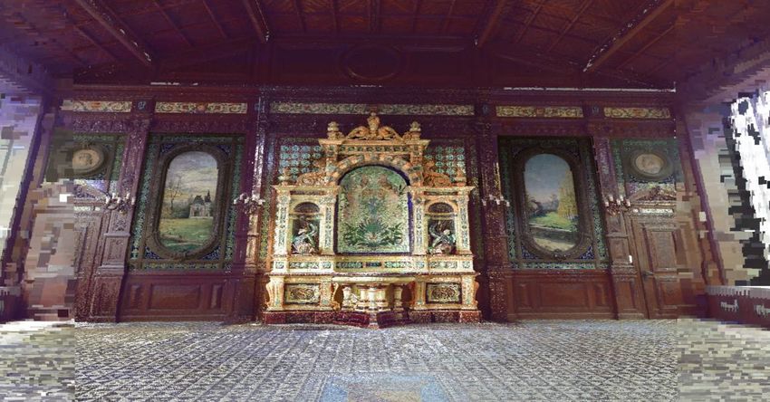
documentation of the Winter Garden at Sarreguemines (Figure build the 3D model of the Winter Garden. The project was
1) became the Master project of Valentin Girardet. georeferenced in the French official geodetic system (RGF93-
CC49 in planimetry and NGF-IGN69 in altimetry). The
challenge was to digitize earthenware, which is a highly
reflective material causing highlights on the images as well as
noise in the processed point clouds. Concerning the
visualization aspect, various experiments were made with a
Virtual Reality system.
2. STATE OF THE ART
As mentioned, digitizing earthenware was the main issue in
this project. On the basis of its extensive experience in 3D
laser scanning and photogrammetry recording (Grussenmeyer
et al., 2016), the INSA Photogrammetry and geomatics Group
team saw the key to success in the control of light conditions
(Tucci et al. 2015) and the homogenization of light to avoid
specular reflections in photogrammetry (Nicolae et al., 2014).
Figure 1. Winter Garden at Sarreguemines (France) Due to technical reasons (large glass walls on both ends of the
(www.sarreguemines-museum.eu) Winter Garden), it was impossible to regulate or homogenize
the amount of light entering the sensor, but the camera chosen
Beside the fountain (its most remarkable piece), the Winter (Canon EOS 5DSR) allowed us to take images in RAW format
Garden also shelters vases, portraits of former directors, views and reprocess them afterwards. In laser scanning, the higher
of the city of Sarreguemines in late nineteenth century as well the intensity of light, the deeper the laser penetration into the
This contribution has been peer-reviewed.
https://doi.org/10.5194/isprs-archives-XLII-2-W15-527-2019 | © Authors 2019. CC BY 4.0 License. 527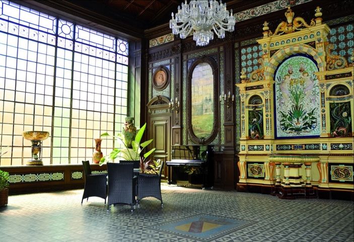
The International Archives of the Photogrammetry, Remote Sensing and Spatial Information Sciences, Volume XLII-2/W15, 2019
          27th CIPA International Symposium “Documenting the past for a better future”, 1–5 September 2019, Ávila, Spain

material (Guidi et al., 2009) and that can potentially cause       Corresponding tools are available in 3DReshaper. All are
biases in distance measurement and increase noise in the point     explained in the software user manual [TECHNODIGIT,
cloud. Data from several 3D recording systems was combined         2016]. Set to an empirically defined value of 10-5, the function
(Faro Focus 3D X330 Scanner, Faro Freestyle 3D hand                "Refining to rope error/ from a point cloud" allowed in
scanner, Canon EOS 5DSR camera, Iphone 8S).                        particular to minimize errors in the mesh by taking false
                                                                   points into consideration. The minimum size of triangles was
           3. 3D MODELLING WORKFLOW                                set to 1 mm (which is the resampling value of the global point
                                                                   cloud) in order to avoid too small triangles. A local smoothing
A well-controlled workflow (Murtiyoso & Grussenmeyer,              was also applied to reduce the noise impact. The best way of
2018) made it possible to obtain point clouds with an accuracy     doing so is to retain the same refining and smoothing
of 2 to 3 mm after registration and georeferencing. In order to    parameters in order to finally get a uniform overall mesh. As
manage large datasets, the Winter Garden has been subdivided       3DReshaper is a commercial software, we had no access to the
into 6 main parts, which in turn are subdivided into 10 sub-       algorithms implemented and can therefore not explain in
parts. The commercial software 3DReshaper was used for the         detail how they work. After having done so for the 6 main
meshing job, as it allows to build a manual mesh. The final        parts, all were put together and combined to form a single
result was achieved by refining a coarse mesh (with an             block, i.e. the Winter Garden (Figure 2).
average distance of 1.5 to 2 cm between future mesh points)
and applying afterwards a smoothing process along with
manual corrections.

                                     Figure 2. Accurate meshed model of the Winter Garden

The last processing step consisted in texturing the model by       visualizing it, it appeared clearly that the mesh size was
applying the images acquired with the SLR camera. This             relatively unaffected by the reduction in size of the model and
operation was not carried out globally (for the Winter Garden      its homogenization. On the other hand, the reduction achieved
as a whole). The different files of the remarkable objects and     in OBJ format was clearly not sufficient to be really
the volumetry were imported separately in OBJ format into          profitable. That is the reason why another method of reduction
the PhotoScan software. The pre-processed georeferenced            based on the "Quadric Edge Collapse Decimation" tool from
texture was then applied. An adequate texture able to maintain     MeshLab was tested, allowing to reduce the size of the model
all the details without producing too large files was chosen       and more particularly the number of triangles while preserving
with great care, as well as the sizes (10000x10000 pixels for      the actual shape of the object [Rodríguez-Gonzálvez et al.
remarkable objects to get sufficient detail on each one of         2015]. Although providing the same advantages as the
them, 40000x40000 pixels for the volumetry because it is the       "Reduce" function of 3DReshaper, it only cut the size of the
maximum texture size that can be calculated by PhotoScan)          OBJ file by 11.5% for half as much triangles.
(Figure 3).
                                                                   Besides, this type of reduction has also a strong impact on
The main disadvantage of textured mesh models lies in the          texture: the higher it is, the more texture is degraded. It was
large size of the resulting files. Two solutions were tested in    therefore rejected and the FBX file format was used for all
order to optimize the models. The "Reduce" function of             exports and imports to overcome the problem. It actually
3DReshaper was the first one, based on a deviation criterion.      compresses the files in such a way that they take up less
It was set to 10-5 m. This empirically defined value enabled us    space. This compression is about 40% for the models of the
to reduce the model without affecting shapes. Doing so, the        remarkable objects and about 70% for the volumetric model of
model was reduced in size by 25% in RSH format (specific to        the Winter Garden.
3DReshaper) against 9.5% only in standard OBJ format. When

                                               This contribution has been peer-reviewed.
                  https://doi.org/10.5194/isprs-archives-XLII-2-W15-527-2019 | © Authors 2019. CC BY 4.0 License.              528
The International Archives of the Photogrammetry, Remote Sensing and Spatial Information Sciences, Volume XLII-2/W15, 2019
27th CIPA International Symposium “Documenting the past for a better future”, 1–5 September 2019, Ávila, Spain
Figure 3. Accurate 3D textured model of the Winter Garden
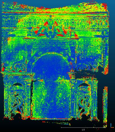
4. PHOTOGRAMMETRIC RECORDING OF A quality was good (Figure 4) and the accuracy was satisfying,
SELECTION OF ARTIFACTS OF THE WINTER as the comparison between the photogrammetric point cloud
GARDEN used to build the model and the reference TLS point cloud on
Cloud Compare led to a standard deviation of 2.3 mm, with a
In order to improve the models, photogrammetric experiments difference being below 3 mm for 75% of the points (Figure 5).
were carried out on some remarkable objects. This is close to the theoretical accuracy of laser point clouds.
Therefore, the smartphone texture was used to overcome
4.1 Experiments based on Smartphone data shortcomings and fill gaps on top of the fountain, because it
was impossible to take pictures at that height with the SLR
Smartphone photogrammetry has experienced a dramatic camera.
development in recent years due to the integration of
increasingly high-performance sensors and components.
During this project, a smartphone was consequently used to
conduct photogrammetric tests, mounted on a gimbal
stabilizer to get the sharpest possible pictures and the
smoothest possible videos.
Figure 4. Textured model of the upper part of the fountain
(extracted from a video)
Several tests were carried out, concerning both photo and
video on the left fish of the fountain and video alone on the
top of the fountain. For that last one, we managed to extract
172 pictures from the video at a rate of one per second. After a
classical photogrammetric modelling process with PhotoScan, Figure 5. Histogram of the number of points according to the
the rendering obtained was quite interesting. The texture laser-point distance (bottom) and associated 3D map (top)
This contribution has been peer-reviewed.
https://doi.org/10.5194/isprs-archives-XLII-2-W15-527-2019 | © Authors 2019. CC BY 4.0 License. 529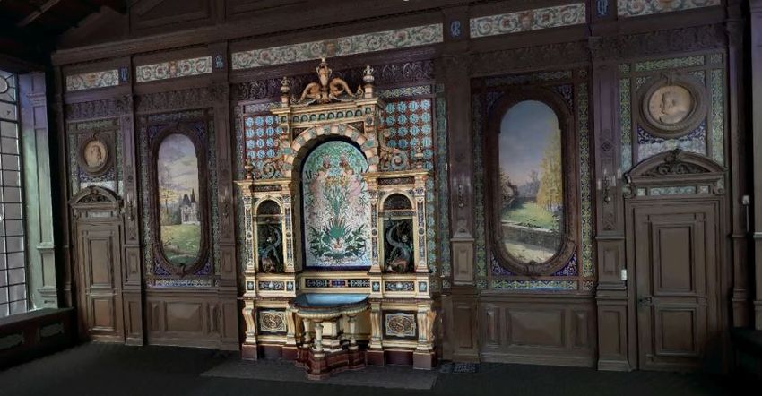
The International Archives of the Photogrammetry, Remote Sensing and Spatial Information Sciences, Volume XLII-2/W15, 2019
27th CIPA International Symposium “Documenting the past for a better future”, 1–5 September 2019, Ávila, Spain
4.2 Programming Image Processing
Image processing solutions aim at correcting the model’s
texture. This can either be done by programming means (on
Matlab, using dedicated toolboxes) or with specialized
software such as the open source GIMP Tool. A histogram
equalization was applied to the RAW images taken with the
Canon EOS 5DSR camera at the bottom of the fountain to
lighten them because they were too dark.
Figure 7. Setup of the Virtual Reality Tool for the “Pavillon
de Geiger” model
Figure 6. Fountain without (left) and with (right) histogram 5.2 Virtual Reality Viewer for an immersive point cloud
equalization visualization
The image processing toolboxes of Matlab were used for that The second solution consisted in using the point clouds of the
purpose, the goal being to smooth out the differences between Winter Garden and its surroundings for an immersive
the textured model at the top (smartphone data acquisition) visualization. The FARO SCENE software and the HTC Vive
and at the bottom (Canon pictures processed) of the fountain system made that possible (Figure 8). The immersion was
(Figure 6). implemented by registering point clouds progressively with
the cloud to cloud method as no sphere was placed inside the
5. VISUALIZATION AND VIRTUAL REALITY Winter Garden.
After the completion of the textured lasergrammetric models
(Winter Garden and remarkable objects), the next objective
was to find out how to best spotlight them. Different
visualization tools such as Sketchfab, Faro Scene VR and
Unreal Engine were taken into consideration here (Kersten et
al., 2018).
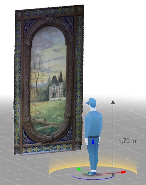
5.1 Uploading 3D models to Sketchfab
The first solution consisted in importing the models of 9
remarkable objects in FBX format on the Sketchfab platform.
This allowed us to respect the maximum import file size rule
Figure 8. Immersion in virtual reality in the Winter Garden
(50 MB at the most) applying to a free basic account. The
light can be fine-tuned to make the models more
An average deviation of 1.3 mm resulted from that registration
photorealistic. It is possible to set the scale to 1:1 in the virtual
with a difference being below 4 mm for 79% of the points.
reality options, enabling thus the user to see objects in real
This is rather satisfying, considering that the point clouds used
size (Figure 7).
came from different acquisition campaigns. The user can thus
move freely in all three dimensions to appreciate the feeling
By doing so, the user has two different ways of visualizing
of space as well as the detail refinement that the cloud offers.
models:
- either from his smartphone by downloading the Sketchfab
5.3 Interactive virtual visit with Unreal Engine
app and wearing suitable glasses (such as Google Cardboard,
Homido headset, Samsung VR headset, etc.) for a quick The third option consisted in setting up a virtual visit scenario
viewing; in the textured model of the Winter Garden and using a video
- or from his computer by navigating to the website and using game engine for that, able to manage large files. Interactivity
a more advanced virtual reality headset (HTC Vive, Oculus has played an important part since buttons have been created
Rift) offering better rendering. especially to enable the user to consult information about
remarkable objects of the Winter Garden and its history
(Figure 9). Consequently, the HTC Vive system has been fine-
tuned with Unreal Engine to allow a model-user interaction
and to program the movements inside the room.
This contribution has been peer-reviewed.
https://doi.org/10.5194/isprs-archives-XLII-2-W15-527-2019 | © Authors 2019. CC BY 4.0 License. 530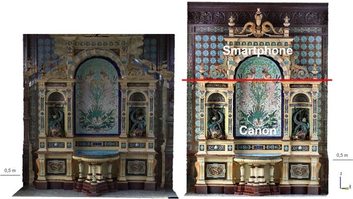
The International Archives of the Photogrammetry, Remote Sensing and Spatial Information Sciences, Volume XLII-2/W15, 2019
27th CIPA International Symposium “Documenting the past for a better future”, 1–5 September 2019, Ávila, Spain
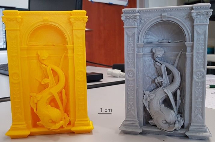
5.4 Printing of 3D objects This booming technology will allow the museum to better
address different audiences. Those 3D printed objects will
The Photogrammetry & Geomatics Group has recently enable a tactile discovery of the Winter Garden for blind
acquired a 3D printer and the project gave us the opportunity people. For children, it could be a recreational way of
to conduct some tests. Both the left fish of the fountain approaching local heritage.
(Figure 10) and the fountain as a whole were printed.
Figure 9. Virtual visit with Unreal Engine
6. CONCLUSION AND OUTLOOK
6.1 Conclusion
The work done allowed us to produce a complete 3D indoor
documentation of the Winter Garden at Sarreguemines. The
difficulties related to the highly reflective nature of
earthenware were bypassed by combining photogrammetric
and lasergrammetric techniques. Aesthetic reasons have led to
the use of up-to-date photogrammetric methods such as
smartphone acquisition. This solution, currently fast
developing, provides rather good results and can replace
traditional methods when those ones are unusable or
unsuitable (for the upper part of the fountain, for example).
Images were additionally processed in two different ways in
order to correct the model’s texture: by programming, to
equalize the histogram of dark pictures (Canon) as well as
manually, by the means of specialized editing software for
touching up isolated defaults. A meshed and textured 3D
model of the Winter Garden has been released with an
accuracy of 2 to 3 mm. As aesthetics is the top criterion for
the museum, such an accuracy is more than enough. The
model will be archived and ready for use in the case of
damages, whatever their cause may be.
Beyond heritage conservation, the project also gave us the
opportunity to test various ways of spotlighting, promoting
Figure 10. Example of 3D printed fish (on the left side of the and visualizing this heritage to show it to a large audience.
fountain) Two interactive virtual tours have been created, one in the
point cloud and one in the model. The Earthenware Museum
This contribution has been peer-reviewed.
https://doi.org/10.5194/isprs-archives-XLII-2-W15-527-2019 | © Authors 2019. CC BY 4.0 License. 531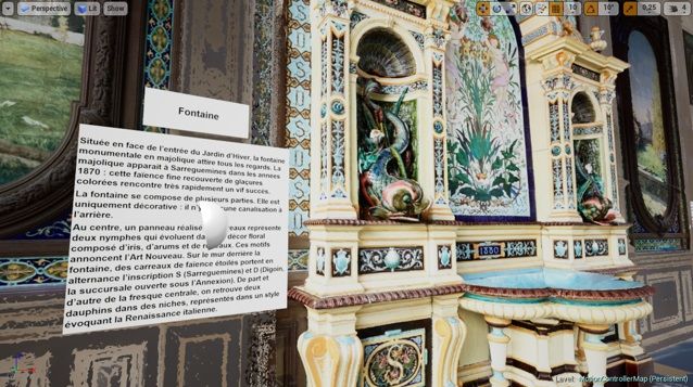
The International Archives of the Photogrammetry, Remote Sensing and Spatial Information Sciences, Volume XLII-2/W15, 2019
             27th CIPA International Symposium “Documenting the past for a better future”, 1–5 September 2019, Ávila, Spain

plans to develop an area dedicated to digital technologies in        International Archives of the Photogrammetry, Remote
near future with the support of the City of Sarreguemines. The       Sensing and Spatial Information Sciences, XL-5/W4, pp. 17-
interactive virtual tours will of course be part of it.              24. doi: 10.5194/isprsarchives-XL-5-W4-17-2015.

6.2     Outlook                                                      Technodigit, 2016. 3DReshaper 2016 MR1 - Beginners Guide.
                                                                     Available at:
Further modelling work can be undertaken at Sarreguemines.           http://www.3dreshaper.com/images/brochures/BeginnersGuide
A second project is on-going at present and will shortly be          _EN.pdf (15 June 2019)
completed, focussing on two more listed buildings, i.e the
“Casino des Faïenceries” and the nearby “Pavillon de Geiger”.        Tucci, G., Bonora, V., Conti, A., Fiorini, L., 2015.
Other remains of the earthenware industry can be found here          Benchmarking Range-Based and Image-Based Techniques for
and there in the city and it could be interesting to digitize        Digitizing a Glazed Earthenware Frieze. In: ISPRS Annals of
them. We are discussing the matter as well as other options          the Photogrammetry, Remote Sensing and Spatial Information
with the city’s authorities.                                         Sciences, II-5/W3, pp. 315-322.
                                                                     https://doi.org/10.5194/isprsannals-II-5-W3-315-2015, 2015.
On the technical level, it may be interesting to try to automate
several steps of the lasergrammetric modelling process as it is
particularly long and tedious. Other methods may also be
tested to reduce the size of models. It could be possible, for
example, to create hybrid models, consisting of geometric
primitives. They could be useful for plain parts (without
particular details) and repetitive elements. Finally, it may be
necessary to improve user movement with virtual reality
system controllers in Unreal Engine for greater fluidity.

                   ACKNOWLEDGEMENTS

The authors would like to thank Mr Céleste LETT (Major of
the City of Sarreguemines) and Mr Jean-Claude CUNAT
(Deputy Major) for supporting this on-going project.

                         REFERENCES

Grussenmeyer, P., Landes, T., Doneus, M., Lerma, J.-L.,
2016. Basics of range-based modelling techniques in Cultural
Heritage (Chapter pp. 305-368). In: 3D Recording,
Documentation and Management of Cultural Heritage,
Publisher: Whittles Publishing, Editors: Efstratios Stylianidis,
Fabio Remondino, 388 pages, ISBN 978-184995-168-5.
Guidi, G., Remondino, F., Russo, M., Spinetti, A., 2009.
Range sensors on marble surfaces: quantitative evaluation of
artifacts, Proc. SPIE 7447, Videometrics, Range Imaging, and
Applications X, 744703; https://doi: 10.1117/12.827251.

Kersten, T.P; Tschirschwitz, F.; Deggim, S.; Lindstaedt, M.,
2018. Step into Virtual Reality— Visiting Past Monuments in
Video Sequences and as Immersive Experiences. In Latest
Developments in Reality-Based 3D Surveying and Modelling;
Remondino, F., Georgopoulos, A., González-Aguilera, D.,
Agrafiotis, P., Eds.; MDPI: Basel, Switzerland; pp. 192–219.
Murtiyoso, A., Grussenmeyer, P., Suwardhi, D., Awalludin,
R., 2018. Multi-Scale and Multi-Sensor 3D Documentation of
Heritage Complexes in Urban Areas. ISPRS International
Journal        of       Geo-Information,      2018, 7(12),
483; doi:10.3390/ijgi7120483.
Nicolae, C., Nocerino, E., Menna, F., Remondino, F., 2014.
Photogrammetry applied to Problematic artefacts. The
International Archives of the Photogrammetry, Remote
Sensing and Spatial Information Sciences, Vol. XL-5, pp. 451-
456. https://doi.org/10.5194/isprsarchives-XL-5-451-2014.

Rodríguez-Gonzálvez, P., Nocerino, E., Menna, F., Minto, S.,
Remondino, F., 2015. 3D Surveying and modeling of
underground passages in World War I fortifications. The

                                                 This contribution has been peer-reviewed.
                    https://doi.org/10.5194/isprs-archives-XLII-2-W15-527-2019 | © Authors 2019. CC BY 4.0 License.            532
You can also read