IMPLEMENTATION OF THE AUTOMATIC PROCESSING CHAIN FOR ARES
←
→
Page content transcription
If your browser does not render page correctly, please read the page content below
© EARSeL and Warsaw University, Warsaw 2005. Proceedings of 4th EARSeL Workshop on Imaging Spectroscopy. New quality in environmental studies.
Zagajewski B., Sobczak M., Wrzesień M., (eds)

          IMPLEMENTATION OF THE AUTOMATIC PROCESSING CHAIN
                              FOR ARES

  Martin Habermeyer1, Andreas Müller1, Stefanie Holzwarth1, Rolf Richter1, Rupert Müller2, Martin
                  Bachmann1, Karl-Heinz Seitz1, Peter Seifert1, Peter Strobl3

1. Deutsches Zentrum für Luft- und Raumfahrt, Deutsches Fernerkundungsdatenzentrum, D-
   82234 Weßling, Germany
2. Deutsches Zentrum für Luft- und Raumfahrt, Institut für Methodik der Fernerkundung, D-82234
   Weßling, Germany
3. DGJRC, Institute for Environment and Sustainability, Land Management Unit, TP 261, I-21020
   Ispra (VA), Italy
   Contact: Martin.Habermeyer@dlr.de

ABSTRACT
DLR and GFZ are procuring the airborne hyperspectral scanner ARES (Airborne Reflective and
Emissive Spectrometer) to be operating from autumn 2005. In order to ensure the first fully auto-
matic processing environment for hyperspectral airborne scanner data working without any user
interaction, a complete processing chain for hyperspectral data is designed. It includes an auto-
matic invocation of system correction, parametric geocoding and atmospheric correction, as well
as the archiving and filing of the resulting data products. This task is performed relying on an op-
erational processing and archiving environment, installed at DLR, where the whole processing
chain is embedded. It empowers the provider and the user of hyperspectral data to utilize a web
interface making the data stock and status transparent. It further grants the operator access to a
professional processing and archiving environment. This ensures an automated generation of
standardized data products, allowing a reproducibility of the data at any time.

INTRODUCTION
DLR (Deutsches Zentrum für Luft- und Raumfahrt) and GFZ (Geo-Forschungszentrum Potsdam)
are acquiring the airborne hyperspectral scanner ARES to be operating from autumn 2005, being
available for the scientific community from 2006.
In order to ensure the first fully automatic processing environment for hyperspectral airborne scan-
ner data working without any user interaction, the whole processing chain is embedded into the
'Data Information and Management System' (DIMS) (Mikusch et al., 2000 (i)), an operational proc-
essing and archiving environment installed at DLR. The following objectives were pursued: auto-
mation and standardization of the processing environment and the resulting data products, ensur-
ing a high quality data standard, utilization of a professional web interface making the data stock
and status transparent to the user, plus offering access to a professional archiving environment.
DIMS provides an archiving subsystem as well as a generic processing environment and a
searchable database including a public access via the WWW.
The processing steps embedded into DIMS include system correction, orthographic rectification
and atmospheric correction, which all rely on well-established software packages operating for
several years. A product model for the automatic processing of airborne optical scanner data at
Level 0 and 1 (raw data and system corrected data) has been presented in by Strobl and Haber-
meyer, 2001 (ii) and Habermeyer et al., 2001 (iii). It is used in this context and allows the fully
automatic ingestion of the data in the processing and archiving system. In the course of the ortho-
graphic rectification by ORTHO (see Müller et al., 2002 (iv)) the attitude and position data recorded
during datatake are synchronized with the scanner data and geo-referenced by the use of a Digital
Terrain Model. This can be provided by the customer. In case no DEM is available the processing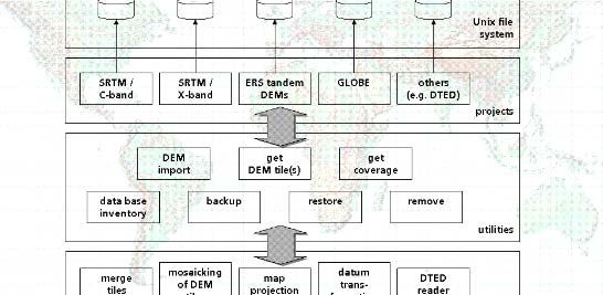
© EARSeL and Warsaw University, Warsaw 2005. Proceedings of 4th EARSeL Workshop on Imaging Spectroscopy. New quality in environmental studies.
Zagajewski B., Sobczak M., Wrzesień M., (eds)

system relies on a digital elevation database operated at DLR and called W42 (Roth et al., 2002
(v)). The task of the atmospheric correction is the calibration of each pixel to ground reflectance.
This is done by the implementation of the software package ATCOR (Richter & Schläpfer, 2002
(vi)), which is based on the radiative transfer model MODTRAN (Berk et al., 1998 (vii)), and inte-
grates the digital terrain model and meteorologic data. Each processing step is followed by a qual-
ity control giving evidence if the quality standards are met.
A data model for geometric and atmospheric correction is described, including the components
available at each processing level plus a set of parameters describing the dataset. This description
of parameters on the one hand facilitates the traceability of the processing steps, while on the
other hand enables the user to view all relevant parameters, when inspecting the data catalogue.
The work is structured as follows: Based upon the data model the design (previously shown in
(viii)) is revisited and the implementation of the processing system is explained, where the interac-
tion of the individual processing components between each other and with the generic processing
environment are shown.
In this context an overview of DIMS is given, with a stress on those components actually employed
for our purposes. In the following the organisation of the processing system is outlined in combina-
tion with an explanation of the work to be done to employ the capabilities of DIMS for the process-
ing system for ARES. An introduction of the sub-systems for system correction, geocoding, the
digital elevation database and atmospheric correction follows. An outlook of the work to be done
concludes this paper.

COMPONENTS OF THE DATA INFORMATION AND MANAGEMENT SYSTEM
DIMS (Data Information and Management System) (for an overview see e.g. Mikusch et al., 2000
(i)) is a generic processing and archiving environment for the purpose of providing services within
the framework of Earth observation product generation, storage, ordering, and delivery. It consists
of several components providing a global product catalogue, storage media transparence and
scalability with respect to storage capacity and data modelling. The parts of DIMS employed for
our purposes are: the Product Library, the Processing System Management and the Operating
Tool. Their interaction is shown in Figure 1.
The Product Library (PL) is responsible for the long-term storage and availability of Earth observa-
tion products. It consists of an extensible product inventory with optimized geo-spatial search ca-
pabilities and a product archive using a robot media library. In DIMS the PL handles input and out-
put of processing systems, input for user information systems, and is the source for product deliv-
ery to end users. For a more detailed description of the PL see Kiemle et al., 2001 (ix).
The Processing System Management (PSM) provides an interface between the sensor-specific
processing algorithms and the processing and archiving facility (x). Its main functions can be iden-
tified as enabling input product retrieval from and output product transfer to the PL, and production
request handling.

                                                                                                                                      68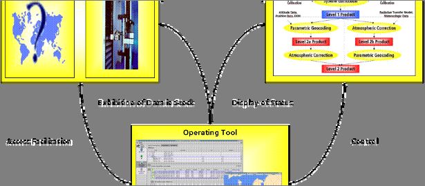
© EARSeL and Warsaw University, Warsaw 2005. Proceedings of 4th EARSeL Workshop on Imaging Spectroscopy. New quality in environmental studies.
Zagajewski B., Sobczak M., Wrzesień M., (eds)

Figure 1: Overview of the Data Information and Management System.
The Operating Tool (OT) is a graphical user interface allowing control of the processing system
and serves as a visualization tool for the data in stock. It is capable of displaying the status of the
processes requested. Access is further facilitated to the PL, in order to provide an interface for
searching as well as exhibiting the data in stock.
Essential for the integration of a processing system into DIMS is a valid data model that allows the
identification of specific datasets, and thus the administration of the dataset in terms of processing
and archiving. The data model for atmospheric and geometric correction is discussed in a subse-
quent section.

OVERVIEW OF THE PROCESSING SYSTEM
The specific processing steps necessary for ARES include system correction, geocoding, and at-
mospheric correction. During system correction artefacts due to the sensor‘s characteristics are
removed and the data is calibrated to at-sensor-radiance based on calibration coefficients attained
during laboratory calibration. In the course of georeferencing the attitude and position data of the
aircraft and the sensor recorded during datatake are synchronized with the scanner data. Further-
more the hyperspectral dataset is rectified by application using a Digital Elevation Model and the
synchronized data. During atmospheric correction atmospheric and topographic effects are re-
moved and the radiance values are converted to ground reflectance for the reflective bands and
surface emissivity and temperature for the thermal bands. Figure 2 gives an overview of the proc-
essing system.
The order of the processing steps depends on the nature of the terrain of the recorded scene: in
case of rugged terrain, geocoding has to precede atmospheric correction, for flat terrain atmos-
pheric correction can be performed prior to geocoding. This difference in the application flow has to
be taken into account when modelling the processing system.
The development of a data model for each processing level, containing the components available
plus a set of parameters describing the dataset, is a fundamental step towards the integration of

                                                                                                                                      69
© EARSeL and Warsaw University, Warsaw 2005. Proceedings of 4th EARSeL Workshop on Imaging Spectroscopy. New quality in environmental studies.
Zagajewski B., Sobczak M., Wrzesień M., (eds)
the processing system into DIMS. For the interaction of the processing subsystems between each
other and with DIMS the PSM-Library is used. The tasks to be performed are ingesting the prod-
ucts into DIMS, and triggering the processing subsystem dependent on the availability of their
product components.
Figure 2: Overview of the Processing System.
Ingestion and System correction
The first step after the data has been recorded onto hard-disk aboard the aircraft is an ingestion of
the dataset into the processing system including the generation of metadata. This can be derived
from various sources: the logging information recorded during data acquisition is read, as well as
parameters intrinsic in the data are extracted or calculated. Some of the information required is not
inherent in the data acquired during recording. This information has to be passed to the processing
system by a human operator or using the results from the flight planning data acquired prior to the
overflight.
After ingesting the product into the processing system, system correction is performed, which
comprises correction of the dark current, removal of system artefacts and finally the radiometric
calibration of the data to at-sensor-radiance by application of the calibration coefficients attained
during laboratory calibration prior to the overflight.
The components of the incoming Level-0 product and the resulting Level-1 product are the hyper-
spectral imagery data, a herefrom generated quicklook, additonal meta-data describing the dataset
and data essential for geometric correction. Valid data for the hyperspectral imagery dataset are
BIL-, BIP-, and BSQ-format. Raw data (Level-0) data in the ARES case is presented in BIL-format
and the system corrected dataset ordered in BSQ-format. The additional metadata describes the
dataset and can be devided into administration-, sensor-, scene-, and software-specific parame-
ters. Those parameters describe the circumstances, under which the scene has been recorded,
provide information needed in subsequent processing steps, hold information concerning quality
control aspects and allow the administration of the product stored by the Product Library. The
quicklook is generated as a first instrument for quality-control, and for a quick provision of the
scene content. Data concerning the external and internal orientation of the sensor is provided for
the purpose of a following geometric correction.
70© EARSeL and Warsaw University, Warsaw 2005. Proceedings of 4th EARSeL Workshop on Imaging Spectroscopy. New quality in environmental studies.
Zagajewski B., Sobczak M., Wrzesień M., (eds)
The data models for Level-0 and Level-1 data have already shown their adequacy during the in-
corporation of DAIS7915 and HyMap data into the DIMS (Strobl and Habermeyer, 2001 (ii),
Habermeyer et al., 2001 (iii)).
Geocoding
In the process of geometric correction the geometric distortions due the movement of the aircraft
and the scanner during data acquisition are removed. In case of the ARES processing chain, we
rely on direct georeferencing software (documented in Müller et al., 2002 (iv)) for an automatic or-
tho-rectification of the imagery, as the system is supposed to work without user interaction. This is
done by reconstructing the scanning geometry for each pixel in the image using the scanner’s inte-
rior orientation, the position and attitude data of the scanner, recorded during data acquisition as
well as a Digital Elevation Model (DEM).
In detail the following product components can be identified: the external orientation file represents
attitude and position data of the scanner and is recorded during data acquisition using DGPS (Dif-
ferential Global Positioning System) and INS (Inertial Navigation System) measurements. The
sensor’s internal orientation is stored within another file. By acquisition of the time at the end of
each scan line and the recording of the positional data together with GPS time it becomes possible
to synchronize the positional and attitude data with the scanner data. The actual geo-rectification
algorithm is performed using the internal orientation, known position and attitude data, and the
corresponding digital elevation model.
Application of the georectification algorithm yields an ortho-rectified imagery, and a file represent-
ing the viewing geometry of the sensor for the particular scene processed which can be used as an
input for the subsequent atmospheric correction.
Atmospheric correction
In the course of the atmospheric correction of airborne optical imagery, the influence of the atmos-
phere, solar illumination, sensor viewing geometry and terrain information are calculated to attain
radiometrically corrected data. For our purposes the latest version of ATCOR4 is employed to cor-
rect the data for ground reflectance. The algorithm is discussed in detail in Richter and Schläpfer,
2002 (vi), at this point the input and output products contributing to a Level-2 product model are
identified and described.
From the overview of the interaction of the described components (Figure 4) the following input
components can be identified: the airborne imagery dataset itself, the scan angle file, the sensor
characteristics, a digital elevation model, and additional data describing temporal and positional
information for the dataset. Those product components have to be made available from prior steps
and should be considered in the models of earlier processing steps, namely system correction and
georectification.
Digital Elevation Database
For both procedures, the geo-rectification and the atmospheric correction the use of a Digital Ele-
vation Model is obligatory. It can be provided by the customer. In case no DEM is available, the
data can be extracted from a Digital Elevation Database with world wide coverage, named W42
(Roth et al., 2002 (v)). Its roots stem from data from Radar Shuttle and Satellite missions. Further
incorporation of other data sources is possible to improve the accuracies of those regions of the
earth, where the information provided is insufficient. On the one hand there are utilities providing
basic database functionality, as import, export, and removal of tiles. On the other hand a whole
suite of routines is implemented to allow the application of the data stored throughout various pro-
jects, e.g. mosaicking and transformation routines. An overview is given in Figure 3.
71© EARSeL and Warsaw University, Warsaw 2005. Proceedings of 4th EARSeL Workshop on Imaging Spectroscopy. New quality in environmental studies.
Zagajewski B., Sobczak M., Wrzesień M., (eds)
Figure 3: W42 – The Digital Elevation Database.
IMPLEMENTATION OF THE SYSTEM
The Product Model consists of data and meta-data describing the dataset, making it possible for
the data provider to stock all data necessary for engineering purposes as well as enabling the user
to check for scene-specific information. Therefore the organization of the data consists of product
components, i.e. single files that can be binary and ASCII data, providing various kinds of informa-
tion, in our case e.g. the data cube, header in various formats plus different kinds of auxiliary data.
These product components are stored in a specific format previously defined, and identical to all
products in that product level. This organisation is together with the meta-information described in
a so called item information file (IIF), which is specified in XML format. The information provided by
the IIF is shown by the Operating Tool. The IIF represents the link of DIMS with the processor.
Figure 4: Foreseen Processing Mechanisms: a)apply geocoding and stop, b) apply atmospheric
correction and stop, c) apply geocoding before atmospheric correction (default), d) apply atmos-
pheric correction before geocoding.
The Processing System has been introduced before. When it comes to an implementation, it is
important to point out again, that there are different sequences, geocoding and atmospheric cor-
rections are passed through: atmospheric correction can be performed prior and subsequent to
geocoding. In case the scene has been acquired over flat terrain and a Digital Elevation model is
not available, it is more appropriate to conduct atmospheric correction right after system correction.
The cases taken into account, are shown in Figure 4 and become understandable when revisiting
Figure 2. From left to right the following situations are addressed: a) apply geocoding and stop, b)
apply atmospheric correction and stop, c) apply geocoding before atmospheric correction (the de-
fault) and d) apply atmospheric correction before geocoding. The different processing mechanisms
have an impact for the processing system as well as for the resulting data models: two types of
72© EARSeL and Warsaw University, Warsaw 2005. Proceedings of 4th EARSeL Workshop on Imaging Spectroscopy. New quality in environmental studies.
Zagajewski B., Sobczak M., Wrzesień M., (eds)
processors have to be foreseen: a type of processor that just feeds the data into in the archive, i.e.
sets up the available data according to the organization of the product model, plus generating the
IIF. This type is called Ingestion Processor. The other type of processor allows processing on de-
mand: the dataset only is processed to a certain level, e.g. stopping at Level 1, Level 2a, after the
geocoding (case 4a) or Level 2b, after the atmospheric correction (case 4b). When additional data
becomes available, the subsequent steps are attempted, based on the information provided by the
Product Model describing the preceding steps. As a consequence, every product has to contain all
parameters and products necessary for subsequent processing.
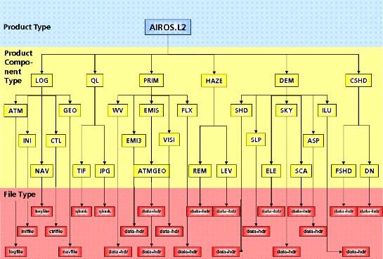
The resulting data model for a completely processed Level-2 product is shown in Figure 5. The
Level-2a product (after parametric geocoding without the application of atmospheric correction),
and the Level-2b product (after atmospheric correction without the application of geocoding) are
both subsets of the Level-2 product. The single components can be described briefly (Figure 5, left
to right):
• The LOG product component contains all the logging accomplished during processing, i.e.
the logging files of ATCOR and ORTHO, as well as their configuration files plus the naviga-
tion file, where attitude and position information for every flight line are stored.
• The QL compontent contains quicklooks in different image formats for a quick visualization
on the screen.
• The PRIM component contains the data cube itself plus a number of value adding products,
e.g. a water vapor, emissivity, heat flux, and visibility maps.
• The HAZE component holds the information about the haze content in the scene, provided
as haze levels and haze removed DN image.
• In the DEM component various files derived from the digital elevation model and the sun
angles are stored.
• In the CSHD component information concerning the cloud shadow in the scene is stored,
provided as shadow removed DN image and fractional solar illumination image.
Figure 5: The Level 2 Product Model
73© EARSeL and Warsaw University, Warsaw 2005. Proceedings of 4th EARSeL Workshop on Imaging Spectroscopy. New quality in environmental studies.
Zagajewski B., Sobczak M., Wrzesień M., (eds)
At all levels a high flexibility in the choice of parameter values is mandatory. In every processing
step there are four types of parameters: those constant for a scene, the ones inherent in the
scene, others that have to be provided from some other source, and the ones that can be calcu-
lated or rearranged from the other types. To take all those possibilities into account, a system-
immanent database is created, with the flexibility to override the default values. This database is
organised in a specific directory structure with an own directory for every parameter block. It is
read before the invocation of the geocoding and atmospheric correction processes.
CONCLUSIONS AND OUTLOOK
The design and implementation of a fully automated processing chain for the upcoming hyperspec-
tral sensor ARES has been displayed. The modules of a generic processing and archiving envi-
ronment necessary for the construction of such a processing chain have been introduced. Based
on the terminology for this introduction the relevant modules of a processing system for hyperspec-
tral scanners have been identified. It has been pointed out, which parameters provide the meta-
information necessary for a unique and adequate description of the data, plus which products
serve as input for the processor’s components as well as which output is produced by each com-
ponent.
As the described data model is generic, the incorporation of other sensors remains to be shown.
References
i MIKUSCH E, E DIEDRICH, M GÖHMANN, S KIEMLE, R REIßIG, K SCHMIDT, W WILDEGGER & M
WOLFMÖLLER, 2000. Data Information and Management System for the Production, Archiving
and Distribution of Earth Observation Products. In: Proceedings of DASIA – Data Systems in
Aerospace, Montreal, Canada, 22-26 May 2000
ii STROBL P & M HABERMEYER, 2001. A generic archiving and processing structure for airborne
optical scanner data. In: Proceedings of the 5th International Airborne Remote Sensing Con-
ference, San Francisco, USA, September 17-20, 2001.
iii HABERMEYER M, P STROBL & A MÜLLER, 2001. Interfacing Airborne Scanner Data to a Generic
Archiving and Processing Environment: a Case Study for the DAIS7915. In: Proceedings of
the 5th International Airborne Remote Sensing Conference, San Francisco, USA, September
17-20, 2001.
iv MÜLLER R, M LEHNER, R MÜLLER, P REINARTZ, M SCHROEDER & B VOLLMER, 2002. A program
for direct georeferencing of airborne and spaceborne line scanner images. In: Mid-term sym-
posium of ISPRS Commission I, WG 1/5 Intergrating Remote Sensing at the Global, Regional
and Local Scale. Colorado, USA, Nov 10-15, 2002.
v ROTH A, W KNÖPFLE, G STRUNZ, M LEHNER & P. REINARTZ, 2002. Towards a Global Elevation
Product: Combination of multi-source digital elevation models. In: Proceedings of the Joint In-
ternational Symposium on Geospatial Theory, Processing and Applications. Ottawa, Canada,
July 9-12, 2002.
vi RICHTER R & D SCHLÄPFER, 2002. Geo-atmospheric processing of airborne imaging spec-
trometer data. Part 2: atmospheric/topographic correction. International Journal of Remote
Sensing 23, no. 13, pp. 2631-2649.
74© EARSeL and Warsaw University, Warsaw 2005. Proceedings of 4th EARSeL Workshop on Imaging Spectroscopy. New quality in environmental studies.
Zagajewski B., Sobczak M., Wrzesień M., (eds)
vii Berk A, L S Bernstein, G P Anderson, P K Acharya, D Robertson, J H Chetwynd & S M Adler-
Golden, 1998. MODTRAN cloud and multiple scattering upgrades with application to AVIRIS.
Remote Sensing of Environment 65, pp. 367-375.
viii HABERMEYER M, A MÜLLER, S HOLZWARTH, R RICHTER, R MÜLLER, K-H SEITZ, P SEIFERT & P
STROBL, 2003. DEVELOPMENT OF A FULLY AUTOMATIC PROCESSING CHAIN FOR THE UPCOMING
HYPERSPECTRAL SCANNER ARES. In: 3rd EARSeL Workshop on Imaging Spectroscopy,
Herrsching, Germany, 13-16 May 2003, edited by M Habermeyer, A Müller & S Holzwarth
(EARSeL, Paris), 82-87.
ix KIEMLE S, E MIKUSCH & M GÖHMANN, 2001. The Product Library: A Scalable Long-Term Stor-
age Repisitory for Earth Observation Products. In: Proceedings of DASIA – Data Systems in
Aerospace, Nice, France, 2001.
x BÖTTCHER M, R REIßIG, E MIKUSCH & C RECK, 2001. Processing Management Tools for Earth
Observation Products at DLR-DFD. In: Proceedings of DASIA – Data Systems in Aerospace,
Nice, France, 2001.
75You can also read