OPST-4 Collection of National Group presentations - UN Decade plans and/or critical updates - Ocean Predict
←
→
Page content transcription
If your browser does not render page correctly, please read the page content below
OPST-4

        Collection of
National Group presentations
 UN Decade plans and/or critical updates

             OPST-4, MS Teams, 16, 17 and 21 June 2021
Systems represented:

Australia (BoM)
Brazil (REMO)
Canada (CONCEPTS)
France (MOi)
Italy (CMCC and OGS)
Japan (MRI-JMA)
Norway (TOPAZ)
South Korea (KIOST)
UK/Europe (ECMWF)
UK (FOAM)
USA (NCEP)
USA (OceanPredict.US)

                        OPST-4, MS Teams, 16, 17 and 21 June 2021
Australia (BoM)
Gary Brassington

             OPST-4, MS Teams, 16, 17 and 21 June 2021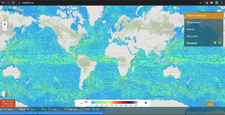
National report - Australia

Plans your operational centre has/is considering for the UN Decade - ForeSea

          • Maximise the benefits of ocean observations
              - Advanced prediction systems (modelling, data assimilation, data science)
              - Support collation/sharing of existing platforms (IMOS, commercial)
              - Support the rapid/efficient uptake of new platforms (SWOT, SKIM)
              - Support building capacity/strategy in adaptive/autonomous platforms (IMOS)
          • Support development and maturation of the full-length op. ocean value chain
              - Support the development of KPI for ocean forecast applications (2 year)
              - Support rigorous forecast verification/evaluation/intercomaprison (IV-TT, ongoing)
              - Support the development and uptake of probabilistic forecasts (2 years)
          • Advance the science behind ocean prediction and its connection to atmosphere
              - Advanced data assimilation (1 year)
              - Ensemble forecasting (2 year)
              - Coupled Numerical Weather-Ocean prediction system (3 years)
                  □ Deterministic/Ensemble – seamless prediction
          • Quantify the impact and utility of ocean prediction
              - Support the development of ocean service KPI (existing, Sea-ice, probabilistic)

         Gary B. Brassington, gary.brassington@bom.gov.au
National report - Australia
Any critical updates related to your operational system/activities of relevance to
the Decade
Specific updates
• Multi-scale data assimilation (BRAN2020 and OceanMAPSv3.4)
• Ocean current verification
• Blue Maps

Other activities
• ForeSea – Bureau/CSIRO
• CoastPredict – CSIRO/Bureau/Universities
• SynObs – CSIRO/Bureau
• DITTO – IMOS, UWA
• Ocean Decade Australia (https://oceandecadeaustralia.org)

               Gary B. Brassington, gary.brassington@bom.gov.au
Brazil (REMO)
Clemente Tanajura -UFBA

             OPST-4, MS Teams, 16, 17 and 21 June 2021
OPST, 16-17, 21 July 2021

                  REMO-CHM Plans Considering the UN Decade
1. The activities related to the UN Decade of Ocean Science for Sustainable Development in Brazil are
organized under the Ministry of Science, Technology and Innovations (MCTI)

2. The Navy will continue its support to
         research in Antarctica
         PIRATA
         NOAA XBT line AX97
         All-Atlantic Research Alliance
         improve the observational system with gliders off S-SE Brazil
         improve the operational forecasting system in the Atlantic

3. The Navy Hydrographic Center (CHM) in collaboration with universities will develop and implement
a regional operational system for detection and forescasting the trajectory of oil spills

4. CHM operational system based on HYCOM+RODAS (EnOI) was upgraded last year to a higher-
resoultion nested grid system and it will work to produce an operational EnKF to improve the forecasts.

                                    OPST-4, MS Teams, 16, 17 and 21 June 2021
Canada (CONCEPTS)
Greg Smith (ECCC)

            OPST-4, MS Teams, 16, 17 and 21 June 2021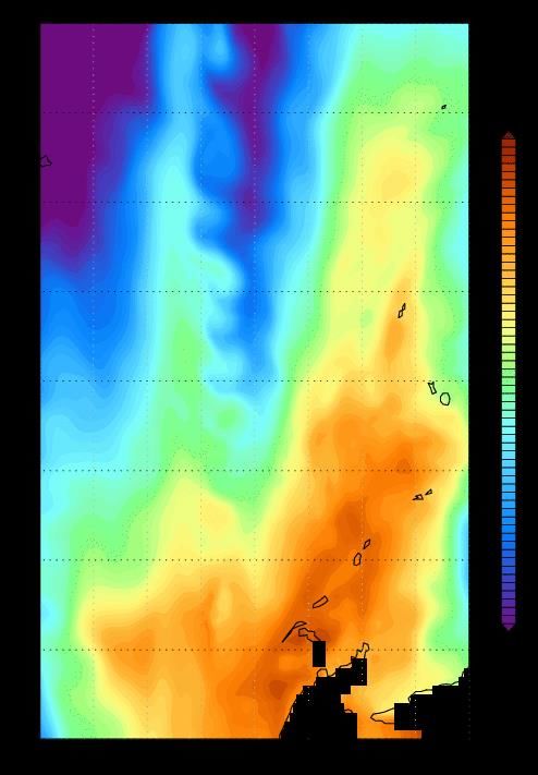
Operational
Canadian National Report                                                                 CICE                    Experimental
Status of Operational Oceanographic Systems
                                                      Seasonal 1°             Great Lakes 2km           Gulf of St.
                   Surface currents
                                                                                         Bathymetry
                                                                                                        Lawrence, 5km

                                                                                                                     Resolution
             GIOPS: 1/4° Global, Coupled
             to GDPS (10day) and GEPS
             (16day and monthly)

                        CIOPS-W: Northeast                                                       CIOPS-E: Coastal East
                        Pacific 1/36°                                                            Coast 1/36°
                                                     RIOPS: Regional 1/12°
                                                     Coupled for YOPP (3km atm)
OPST4, June 2021                             OPST-4, MS Teams, 16, 17 and 21 June 2021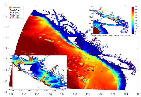
DFO Applications                           CONCEPTS
• Fisheries and Aquaculture
  management                        Users and Applications                     METAREAS 17&18
• Ocean climate monitoring

DND Applications
• Situational awareness
• Anti-submarine warfare
• Operational support                                                     CIS Operations
                                                                          •     High-pressure ridges
                                                                          •     Automated analyses
                                                                          •     Iceberg drift
    Canadian Coast Guard
    • Search and Rescue
    • Environmental                                                                Downstream systems
                                                                              CIOPS, e-Nav, Waves, storm surge
      Emergency Response
                                         National
                                      Environmental
                                    Emergency response
                                      Centre (NEEC)
                                        • Oil spill
                           OPST-4, MS Teams, 16, 17 and 21 June 2021   CIOPS-West                  CIOPS-East
• Installation of Port-scale models
Potential • Expand products to external Government of Canada users
• BGC model development based on NEMO and other models
UN Decade Plans • Developing hindcasts, S2S prediction and climate projections
• Enhance data assimilation and developing reanalysis products
• Promoting more applications of model products to support the Blue Economy strategy
Implemented Aug. 2019
Near-shore NEMO
on-demand config for select regions
E-Nav Kitimat
E-Nav Fraser
E-Nav Vancouver
RIOPS CIOPS
Near-shore NEMO
on demand configs for select regions
H2D2 St. Lawrence
E-Nav Canso
E-Nav Saint John
Implemented Jun. 16,
OPST-4, MS Teams, 2020
17 and 21 June 2021France (Moi)
Yann Drillet
OPST-4, MS Teams, 16, 17 and 21 June 2021Mercator Ocean International
• Plans for the UN decade :
1. Continuity of operational production of ocean short term forecast and ocean
reanalysis for the global ocean and for Irish Biscay and Irish sea area.
2. Strong focus on biogeochemistry and biodiversity
3. Develop Digital Twin Ocean concept based on model & data assimilation technics
and more flexible and interactive engine including big data, cloud platform, machine
learning and on demand model and whatif scenario.
• Main critical updates for the next decade
1. Resolution, move to 1/36° global forecasting system
2. Uncertainty, move to ensemble analysis and forecast systems
3. Coupling, improve coupling between main components of the ocean system
(physics, biogeochemistry, sea ice, atmosphere, waves, rivers, low, mid and high
trophic level models …)
OPST-4, MS Teams, 16, 17 and 21 June 2021Italy (CMCC and OGS)
Simona Masina
OPST-4, MS Teams, 16, 17 and 21 June 2021Global ocean oil spill forecasting: CMCC, MOI and OrbitalERO Bulletin for MV X-Press
Italian operational centers (CMCC and OGS) Pearl chemical and oil leaks in support of response and clean-up, June 2021
plans considering for the UN Decade
Simulated oil spill trajectory by
CMCC and MOI.
Sentinel-2 image for
the 08/06/2021 00:25
CMCC Contributing to ForeSea: UTC by OrbitalEOS.
• Global and Regional forecasting, ocean visualization,
• added value products at Global scale (e.g. Oil spill forecasting in
http://oceanity.eu
collaboration with MOI)
multimodel multi scale ocean visualization
CMCC Contribution to CoastPredict:
• Part of the Steering committee of CoastPredict
• Global to coastal applications (WITOIL multimodel oil spill
forecasting global, regional (CMEMS) and coastal service)
• Two projects proposal proposed in the framework of CoastPredict:
1) “NAVIgating in the COASTal ocean“ (NAVICOAST)
2) Support for marine pollution in coastal zones
CMCC Contributing to the Italian National Committee for the Ocean
DecadeItalian operational centers (CMCC and OGS) plans considering for the UN Decade
Considering objectives of the UN decades, the OGS plan for model developments
includes several major system upgrades toward an ecosystem approach:
- Including pollutants in ecosystem modelling to support a clean ocean
- improving predictability by model developments: novel optics, diversity of plankton
components (e.g., PFTs, mixoplankton), better resolved carbon cycle (microbial food
web vs classical food chain; POC and DOC dynamics), benthic-pelagic coupling, land-
ocean coupling)
- Improving predictability using new generation of biogeochemical data assimilation
(new datastreams – new satellite products, bgc-float and glider -, and ensemble
data assimilation scheme)
- Coupling low and high trophic level modelling (e.g., suitability model for sensible
species and fisheries and E2E modelling) to support a healthy and resilient and a
sustainable harvested oceanCritical updates related to Italian CMCC operational system of relevance to the Decade
Italy will continue to improve the Mediterranean operational systems for the physical and biogeochemical components in
the framework of the Copernicus Marine Service (CMEMS) within the Med-MFC consortium to support users, services and
applications for societal activities in a sustainable way
The perspectives for the UN decade developments include several major system upgrades:
• a fully coupled physics-wave system
• improved representation of the vertical dynamics
• better representation of river inputs in the coastal areas
• ensemble forecasting achieved by perturbing the
atmospheric forcing and the initial conditions
• development of an atmo-ocean-wave coupled system
Italy will also continue to improve the Global Ocean Forecast System at 1/16∘ GOFS16
http://gofs.cmcc.it/ including:
• a new atmospheric forcing
• tidal components
• assimilation of sea ice concentration and sea ice thickness
• improved validation toolJapan (MRI-JMA) Goro Yamanaka
Summary for current JMA operational systems
Global system - MOVE/MRI.COM-G3           Planned for operational implementation in 2021
    • Analysis model (G3A)
        ➢ Resolution: 1ox0.3-0.5o                                  G3A-4DVAR SST (1º×0.3-0.5º)               G3F-IAU SST (0.25º×0.25º)

        ➢ 4DVAR for T/S
        ➢ 3DVAR for sea-ice
    • Forecast model (G3F)
        ➢ Resolution: 0.25o x 0.25o
        ➢ Initialized with G3A through IAU downscaling

Regional system
                                                                                      ➢ TIWs slowly move westward realistically in
   • Analysis model - MOVE/MRI.COM-NP
                                                                                        the data assimilation systems.
       ➢ Domain: North Pacific (15oS-65oN, 100oE-75oW)
       ➢ Resolution: 10km (1/9o x 1/11o)                                                         MGD-SST (0.25º×0.25º)
       ➢ 4DVAR for T/S
       ➢ 3DVAR for sea-ice
   • Forecast model - MOVE/MRI.COM-JPN
       ➢ Domain: Japan Area (20-52oN, 117-160oE)
       ➢ Resolution: 2km (1/50o x 1/33o)
       ➢ Initialized with MOVE-NP through IAU downscaling
                                          OPST-4, MS Teams, 16, 17 and 21 June 2021
marine debris
JMA activities to engage with the UN Decade aquaculture
- plans of operational system in the Decade
providing information for societal benefit using operational system adult
wind power generation
・prediction of coastal currents and temperatures for aquaculture
・prediction of marine debris drift
・environmental assessment of offshore wind power generation
- critical updates related to the operational system of relevant to the Decade
providing new high-resolution global SST products by directly assimilating satellite data
・application to weather forecasting
・application to marine resource management
OPST-4, MS Teams, 16, 17 and 21 June 2021Norway (TOPAZ)
Laurent Bertino (NERSC)
OPST-4, MS Teams, 16, 17 and 21 June 2021Norway – Pan-Arctic forecasts and
reanalysis systems
• Latest news 2020 – 2021, part of CMEMS • Plans 2022-2028
- TOPAZ6: - 6km EnKF (TOPAZ5) and 3km deterministic (TOPAZ6).
- Prepare for new Copernicus Polar missions: CIMR,
- 3km HYCOM Arctic tidal and storm surge model, CRISTAL.
nested in Global MOi NEMO. Daily 10-days forecast.
Used for Norwegian preparedness response. - Wave terms in ocean
- Improved river runoff (Arctic-HYPE)
- neXtSIM-F:
- Lagrangian adaptive-mesh sea ice forecast. Brittle-
Bingham-Maxwell (BBM) rheology. Improved ice drift
forecast. • (Potential) Contributions for The Decade,
depending on funding.
- ECOSMO2:
- 6km NRT biogeochemical model. 50 layers. Carbon - Safe ocean:
Cycle. Simple Assimilation of Ocean Colour. - Forecasting targeted sea ice navigation (with large
leads)
- WAM: - “Iceberg risk zone” forecasting
- 3km Arctic wave forecast and hindcast
- Predictable ocean:
- TOPAZ4b reanalysis: - Interpretable ensemble forecast
- 50 hybrid layers. - BGC-augmented fish habitat
- ECOSMO reanalysis: one-lag EnKS
OPST-4, MS Teams, 16, 17 and 21 June 2021South Korea (KIOST)
Do-Seung Byun
OPST-4, MS Teams, 16, 17 and 21 June 2021Proposed Decade Contributions by KIOST
The “ROSE” Center (The Center for Recovering the Ocean towards a Sustainable Earth)
Oceanic effects on climate variability of the Northwest Pacific Mesopelagic ecosystem in the Pacific Ocean
◆ Understanding and predicting climate variability in the Northwest Pacific and its consequences
in order to mitigate climate crisis
◆ Understanding the structure and function of the mesopelagic ecosystem in the Pacific Ocean
UN SDG : GOAL 13, 14, 17
OPST-4, MS Teams, 16, 17 and 21 June 2021UK/Europe (ECMWF)
Kristian Mogensen
OPST-4, MS Teams, 16, 17 and 21 June 2021Summary and plans for current ECMWF
operational systems
• Ocean model configurations
• Current ocean model is based on NEMO V3.4.1 with local ECMWF modifications
• Same ocean grid with about 0.25 degree resolution used for all operational systems
• Ocean analysis systems (BRT and RT):
• ocean5: NEMOVAR 3D-VAR FGAT
• T/S/SLA/SIC observations, SST via relaxation
• All forecasting systems are coupled (atmospheric resolution list below)
• HRES CY47R1 (30/6-2020) 9 km deterministic 10 days twice daily
• ENS CY47R1 18 km 51 members 15 days twice daily
• Monthly CY47R1 36 km 51 member 46 days Monday and Thursday 0z
• SEAS5 CY43R1 (November 2017) 36 km 7 months every month, 13 months every 3 months
• Plans for the next ocean model upgrade (2022 target)
• Upgrade to NEMO V4. Biggest change is the LIM2 (mono-cat) to SI3 (multi-cat) sea ice model
• Resolution will likely stay the around 0.25 degree for the ocean.
EUROPEAN CENTRE FOR MEDIUM-RANGE WEATHER FORECASTS October 29, 2014 26
OPST-4, MS Teams, 16, 17 and 21 June 2021UK (FOAM)
David Ford (Met Office)
OPST-4, MS Teams, 16, 17 and 21 June 2021UK Met Office
• Engage with ForeSea, SynObs, and related projects
• Further international collaborations such as CMEMS, NEMO, NEMOVAR, etc
• High resolution coupled ocean-wave-atmosphere forecasts including ensembles with
increased forecast frequency and longer lead times
• Implement hybrid ensemble-variational data assimilation
• Investigate strongly coupled data assimilation
• Increased focus on high coastal resolution and biogeochemical applications
• Improved modelling and reanalysis for recent/future changes in sea level and the regional
marine environment around the UK
• Exploit new data types for assimilation, and contribute to observing system design
• Improved verification techniques and provision of uncertainties and probabilities
www.metoffice.gov.uk OPST-4, MS Teams, 16, 17 and 21 June 2021 © Crown Copyright 2021, Met OfficeUSA (NOAA-NCEP)
Avichal Mehra
OPST-4, MS Teams, 16, 17 and 21 June 2021NWS-Unified Forecast System
● NWS UFS system consists of the
following community components
○ NEMS for infrastructure
○ CMEPS mediator
○ FV3 dycore with CCPP Physics driver
○ MOM6 ocean model (S2S scales)
○ HYCOM ocean model (weather scales)
○ WW3 wave model
○ CICE6 ice model
○ NOAH-MP LSM
○ GOCART Aerosol model
● Each component has its own authoritative
repository. NEMS infrastructure allows
flexibility to connect instantiations of the
repositories together to create a coupled
model.
● https://ufscommunity.org
OPST-4, MS Teams, 16, 17 and 21 June 2021NWS-Unified Forecast System
● Infrastructure for coupling models together:
○ NOAA’s Environmental Modeling System
(NEMS) drivers and caps
NEMS (Main Program)
○ Community Mediator for Earth Prediction
Systems (CMEPS)
○ National Unified Operational Prediction CMEPS Mediator
Capability (NUOPC) conventions
● Infrastructure for interoperable physics:
Atmosphere: Ocean: Ice:
○ Common Community Physics Package FV3GFS MOM6 CICE6
(CCPP) framework
● Infrastructure for data assimilation: Joint Effort for
Data assimilation Integration (JEDI) Wave:
WW3
Common Goals with UN Decade of the Ocean:
Enhance Operational Earth Prediction Enterprise for all temporal scales (weather-to-subseasonal-to-seasonal)
and include Global, Regional and Coastal UFS applications.
Leverage developments with UN endorsed Ocean Decade activities including ForeSea, OASIS and CoastPredict.
OPST-4, MS Teams, 16, 17 and 21 June 2021Development of Fully Coupled Unified Forecast System
for Weather-to-Seasonal-to-Subseasonal Applications
Summarized Week 3&4 AC skill
Multiple prototypes of a fully coupled system (FV3-MOM6-CICE6-WW3-NOAH_MP-GOCART-
CMEPS) have been completed. These prototypes target the next operational versions of GFS
(medium-range), GEFS (sub-seasonal) and SFS (seasonal) forecast systems at NOAA/NCEP.
OPST-4, MS Teams, 16, 17 and 21 June 2021USA (OceanPredict US)
Eric Chassignet
OPST-4, MS Teams, 16, 17 and 21 June 2021OceanPredict.US
Coalescing the Nation’s Operational Oceanography Enterprise
Vision:
Establish a framework for the U.S. operational oceanography enterprise,
enabling the earth system science value chain from observation to
decision-making and societal benefit.
OPST-4, MS Teams, 16, 17 and 21 June 2021Objective
• OceanPredict.US aims to:
• Coalesce existing U.S. operational oceanography components into a coherent national
enterprise, transformatively establishing a framework for sustained operations,
comparable to the Nation’s weather enterprise, spanning the blue (physical), white (sea
ice), and green (ecological) ocean components.
• Enable informed decision-making for societal benefit, greater return on ocean-related
investments, and integration of activities contributing to the ocean observation value
chain, spanning observations, analyses, predictions, products, and services.
• Evolve the Nation’s operational oceanography enterprise beyond the existing collection
of ocean-related research activities and operational endeavors to a sufficient network of
infrastructure and sustained operations at national, regional, and local levels.
• This transboundary effort seamlessly transitions from the open ocean to the coast and
tropics to the poles for short-term “weather” to anthropogenic-forcing time scales.
• This strongly interdisciplinary effort connects the physical, biogeochemistry, and social
sciences for societal benefit uses through integration and exploitation of ocean
observations.
• Provide a locus for transitioning governmental, non-governmental, and private sector
research to operations for value-added products and services supporting informed
decision-making.
OPST-4, MS Teams, 16, 17 and 21 June 2021Status
• Proposed “Ocean-Shot”, OceanPredict.US, submitted to the U.S. National
Committee for the UN Ocean Decade
• Initial engagement:
• Cross-NOAA discussion
• National Ocean Service (NOS)
• National Weather Service (NWS)
• National Marine Fisheries Service (NMFS)
• Office of Oceanic and Atmospheric Research (OAR)
• National Environmental Satellite, Data, and Information Service (NESDIS)
• IOOS Association (non-profit) – Working with the 11 U.S. IOOS Regional Associations
and Federal partners
• Industry group – Consortium for Ocean Leadership
• Nominated NOAA Administrator
• Under Secretary of Commerce for Oceans and Atmosphere
• Recent past Acting NOAA Administrator
• Under Secretary of Commerce for Oceans and Atmosphere
• Website established – pending initial content
OPST-4, MS Teams, 16, 17 and 21 June 2021You can also read