AUSTRALIA'S FUTURE NATIONAL HEATWAVE FORECAST AND WARNING SERVICE: OPERATIONAL CONSIDERATIONS - Bushfire & Natural ...
←
→
Page content transcription
If your browser does not render page correctly, please read the page content below
AUSTRALIA'S FUTURE NATIONAL
    HEATWAVE FORECAST AND
 WARNING SERVICE: OPERATIONAL
       CONSIDERATIONS.
Non-peer reviewed research proceedings from the Bushfire and Natural Hazards
                          CRC & AFAC conference
                            Perth, 5 – 8 September 2018

   John Nairn1,, Robert Fawcett2, Linda Anderson-Berry2, Bertram Ostendorf3, Peng Bi3, Chris
                                 Beattie4, Mark Cannadine5

                1. Bureau of Meteorology, Adelaide, South Australia, Australia
                   2. Bureau of Meteorology, Melbourne, Victoria, Australia
                3. University of Adelaide, Adelaide, South Australia, Australia
               4. State Emergency Service, Adelaide, South Australia, Australia
                      5. Department of Health, South Australia, Australia

                     Corresponding author: john.nairn@bom.gov.au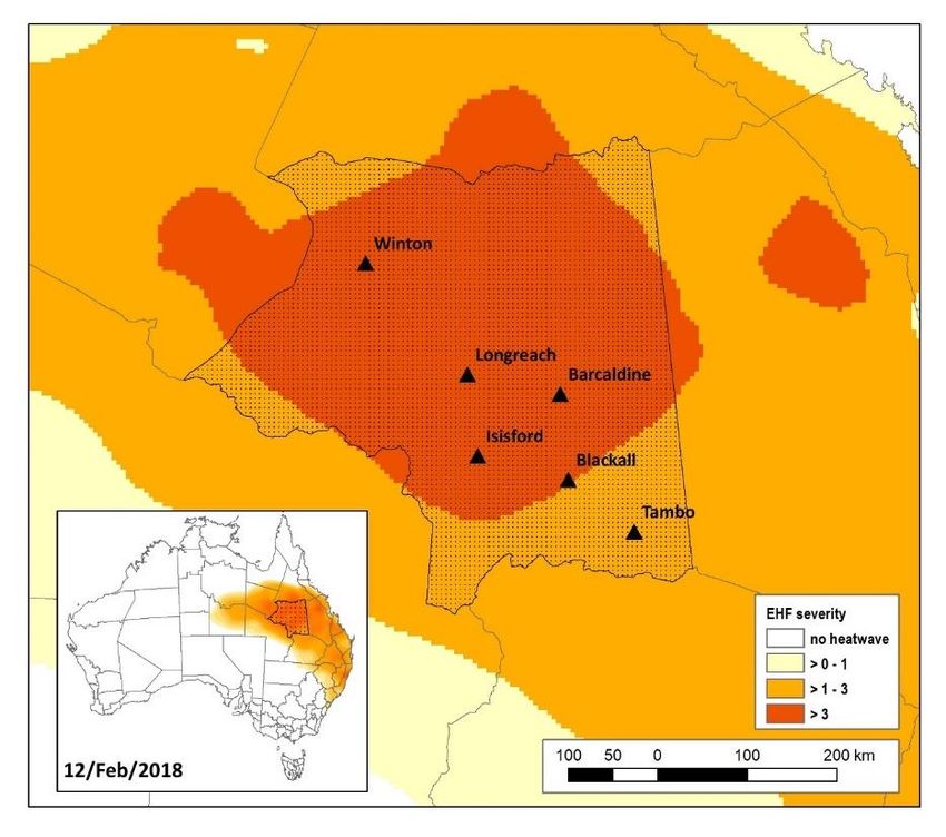
AUSTRALIA’S FUTURE NATIONAL HEATWAVE FORECAST AND WARNING SERVICE:
    OPERATIONAL CONSIDERATIONS | REPORT NO. 374.2018

       Version        Release history                                      Date

       1.0            Initial release of document                          05/09/2018

 This work is licensed under a Creative Commons Attribution-Non Commercial 4.0
 International Licence.
 Material not licensed under the Creative Commons licence:

       •      Department of Industry, Innovation and Science logo
       •      Cooperative Research Centres Programme logo
       •      All photographs and graphics.

 All content not licenced under the Creative Commons licence is all rights
 reserved. Permission must be sought from the copyright owner to use this
 material.

 Disclaimer:
 The Bureau of Meteorology, University of Adelaide, State Emergency Service
 Adelaide, the Department of Health South Australia and the Bushfire and Natural
 Hazards CRC advise that the information contained in this publication comprises
 general statements based on scientific research. The reader is advised and needs
 to be aware that such information may be incomplete or unable to be used in
 any specific situation. No reliance or actions must therefore be made on that
 information without seeking prior expert professional, scientific and technical
 advice. To the extent permitted by law, The Bureau of Meteorology, University of
 Adelaide, State Emergency Service Adelaide, the Department of Health South
 Australia and the Bushfire and Natural Hazards CRC (including its employees and
 consultants) exclude all liability to any person for any consequences, including but
 not limited to all losses, damages, costs, expenses and any other compensation,
 arising directly or indirectly from using this publication (in part or in whole) and any
 information or material contained in it.

 Publisher:
 Bushfire and Natural Hazards CRC

 September 2018

Citation: J Nairn, R Fawcett, L Anderson-Berry, B Ostendorf, P Bi, C Beattie, M
Cannadine. (2018). Australia’s future national heatwave forecast and warning
service: operationalise considerations. In J.Bates (Ed.), Research Forum 2018:
proceedings from the Research Forum at the Bushfire and Natural Hazards CRC &
AFAC Conference. Perth: Bushfire and Natural Hazards CRC.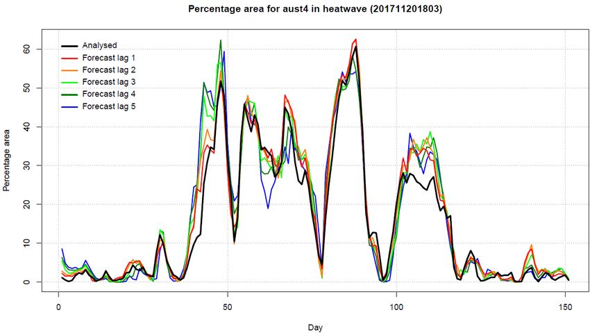
AUSTRALIA’S FUTURE NATIONAL HEATWAVE FORECAST AND WARNING SERVICE:
OPERATIONAL CONSIDERATIONS | REPORT NO. 374.2018

ABSTRACT
     Heat wave is Australia's deadliest natural hazard. It is responsible for more hazard-
related deaths than all other natural hazards combined. The incidence of severe and
extreme heatwaves in Australia has been considerable and is projected to increase. Recent
efforts to mitigate the impact of this rising frequency and severity of heatwave events across
the nation has witnessed State and Territory authorities warning for impacts across human
health, infrastructure, utilities, community events and business activities whilst the Bureau
of Meteorology introduced a national heatwave service. Consultation across emergency
services, health and media sectors has established the requirement for a national heatwave
warning framework. Within the health sector separate calls have been made for a
nationalised approach to heatwave warnings.
     We describe an operational partnership model for emergency and health agencies
community information and warnings facilitated by the Bureau's future heatwave forecasts
and warnings in a multi-hazard warning framework.
     Epidemiological studies have demonstrated that the Bureau's severity scale has skill in
predicting health impacts in Western Australia, South Australia and New South Wales. The
UK Meteorological Office has included the Bureau's heatwave and coldwave methodology
in their Global Hazard Map project where it is also demonstrating acceptable levels of
accuracy in identifying high impact events around the world.
     The Bureau has supplied a national warm season heatwave severity service since
January 2014 in the form of seven continental scale severity maps, updated once a day.
Predictive skill and heatwave event severity characterisation reports for summers 2013-
14, 2014-15, 2015-16 and 2016-17 have been circulated to the Bureau's internal Heatwave
Services Reference Group to enable consideration and validation of the current heatwave
service. This verification work is scheduled to continue with upgraded diagnostics included
here for the 2017-18 season.
     Future emergency services and human health information and warning services are
prototyped using recently developed gridded heatwave service data. Heatwave forecast and
warning services are demonstrated to characterise how each partner's information and
warning services would have been supported during the 2017-18 summer.
AUSTRALIA’S FUTURE NATIONAL HEATWAVE FORECAST AND WARNING SERVICE:
OPERATIONAL CONSIDERATIONS | REPORT NO. 374.2018
EXTENDED ABSTRACT
Heatwave is now clearly understood to be Australia's deadliest natural hazard. Where
once it was difficult to directly and accurately attribute deaths to discrete periods of
extreme heat, (heatwaves), robust methodologies can now be applied to define and
measure the direct and indirect, and tangible and intangible impacts of heat on human
health and wellbeing (including mortality and morbidity), livelihoods, industry (including
energy) infrastructure and agriculture.
Since the late 1800's extreme heat events have killed at least 5332 people and throughout
the twentieth century heatwaves have been responsible for more than the sum of all other
hazard related fatalities. More recently, in the period 2000 to 2010, 475 deaths are
directly attributed to 8 events, including 435 from the 2009 Southern Heatwave, and 2
other events where over 10 deaths occurred (Risk Frontiers).
The entire Australian community is at some risk of suffering some level of harm or loss
related to heat. The Australian Business Roundtable Report (p18) identified that in the 30
years between 1987 and 2016, 509 deaths; 2,800 injuries; and a total of 4,603,00 people
were affected. They noted that during heatwaves generally there are more hospital
admissions for mental health issues, workplace accidents and injuries, power outages and
transport interruptions; which disrupt supply chains, businesses and community services
and increase both the direct and indirect economic costs.
Heatwaves trends and projections exhibit an increase in frequency and intensity under
a warming climate (Alexander et al., 2009; Kiktev, Sexton, Alexander, & Folland, 2004;
Meehl & Tebaldi, 2004; Perkins, Alexander, & Nairn, 2012; Russo et al., 2014; Tollefson,
2012). Heatwaves extract a heavy toll upon vulnerable communities and on rarer occasions
high intensity impacts spread to healthy people through failure of infrastructure, utilities
and inadequate adaptation strategies (Department of Human Services & Victorian
Government Department of Human Services Melbourne, 2009; Le Tertre et al., 2006;
Mechler, Hochrainer, Aaheim, Salen, & Wreford, 2010; Yates, 2013).
Historically, human communities at greatest direct risk and most vulnerable to the health
impacts during heatwaves have usually been considered to be the elderly, the very young
and those working outdoors. However, in recent times death rates have decreased in the
very young, most likely due to the wide availability of air conditioning and good
monitoring of hydration and infant health. In the over 75 age bracket both mortality and
morbidity rates are now marginally increasing. This may be related to increased
opportunity for underlying health conditions that make them more susceptible. Australia's
population is aging and this will increase the numbers in this at-risk cohort. Based on
medium-level growth assumptions, the Australian Bureau of Statistics (ABS) projects the
population to grow to 28.8 million by 2030 with the number of people aged 65 and over to
rise by 91% and those aged 85 and over to more than double (ABS, 2008b). The elderly
are also more likely to be increasingly living alone in urban dwellings where security
concerns encourage keeping windows and doors closed, thus reducing ventilation, and
economic concerns discourage the use of air-conditioning. Risk relating to exposure, on
the other hand, is decreasing and with effective early warning can continue to decrease.
Those working outdoors and exposed to the elements in relation to work such as farming,AUSTRALIA’S FUTURE NATIONAL HEATWAVE FORECAST AND WARNING SERVICE:
OPERATIONAL CONSIDERATIONS | REPORT NO. 374.2018
mining, labouring and travelling and those engaging in extreme sporting activities can
reduce their exposure and thus their risk with effective risk mitigation actions.
With or without climate warming, climatic extreme warning systems are required to
reduce the risk of disasters, (Kovats & Kristie, 2006; Zia & Wagner, 2015). Choice of
heatwave indices suitable for use in these systems must satisfy the following criteria:
1. Extreme values match user experience,
2. Useful as indicator of impact ,
3. Seamless services across climate records, 7-day, multi-week, seasonal and
climate projection forecasts,
4. Ease of interpretation, and common to both policy and operational users
5. Mapped to provide timely and locally specific guidance, and
6. Operate within a multi-hazard warnings framework
Agencies tasked with generating the necessary environmental assessments, forecasts
and warnings must also consider how policy-makers across the health sector, infrastructure
and utilities can prepare and adjust to future climate scenarios. National meteorological
agencies now consider seamless services as an achievable standard. Weather service
infrastructure is easier to sustain and maintain, and enables clearer forecast and warnings
messages consistent with a common protocol. A common message used in climate
assessments and projections is more readily adopted when coupled with seamless daily,
weekly and even seasonal forecast schemas. Policies that are replicated in operational
practices will improve adoption and communication, and allow better partnerships within
and between agencies.
Effective mitigation and response requires a negotiated national heatwave warnings
framework in which the national weather service, emergency services and health agencies
coordinate messages. The diversity of Australian extreme heat hazard lead-agencies across
state and territory jurisdictions mandates the development of this framework to ensure a
consistent service for the Australian community.
Recent investigations have focused on the need to understand and measure heatwave
intensity in a manner that is meaningful for each location. Percentiles-based heatwave
metrics are recommended to satisfy the locality criteria (Perkins & Alexander, 2013), whilst
the development of an intensity calculation that is meaningful to any sector has produced
the Heat Wave Magnitude Index (HWMI) and its daily derivative HWMId (Russo, Sillmann,
& Fischer, 2015). Similar to HWMI, the Excess Heat Factor (EHF) (Nairn & Fawcett, 2014)
measures heatwave intensity at each location with an additional component to account for
adaptation. Whilst similar in principle to HWMI, EHF has distinctions worthy of note. Rather
than the use of maximum temperature alone, daily temperature is considered important
due to minimum temperature compounding extremes through modification of the diurnal
heating cycle (Black, Blackburn, Harrison, Hoskins, & Methven, 2004; Chen & Zhai, 2017).
EHF’s assembly from long and short-term daily temperature anomalies creates a power-law
time series that permits a novel normalization technique to build a dimensionless severity
index (see Appendix A for derivation and supporting examples). Severity analyses have
spatial and temporal consistency that has enabled the development of heatwave services.
The Bureau of Meteorology in Australia(the Bureau) and National meteorological
agencies, the UK and United States have either put into operation or under evaluation the
Excess Heat Factor (Nairn & Fawcett, 2014) for heatwave severity analysis and forecasts.
The Bureau’s heatwave service has published 7-day heatwave severity maps on the internet
since 2014 (Bureau of Meteorology, 2014). The UK Met Office is evaluating 7-day
probability maps of heatwave (and coldwave) within their Global Hazard Map (GHM)AUSTRALIA’S FUTURE NATIONAL HEATWAVE FORECAST AND WARNING SERVICE:
OPERATIONAL CONSIDERATIONS | REPORT NO. 374.2018
project (Helen A. Titley and Joanne C. Robbins, 2013) whilst the Bureau (Hudson & Marshall,
2014) and NOAA (personal communication, University of Maryland) have funded
experimental multi-week probability maps. The Bureau is also contributing EHF heatwave
severity maps to the Copernicus project (Gobron et al., 2016) for users to envisage
meaningful heatwave climate change scenarios.
Percentile-based heatwave indices can be spatially constrained as their scaling against
local climate variability can inhibit sensible inter-site comparisons and spatial analysis.
They are reliable for time-series analysis at each location and spatially analysed for climate
change purposes when rates of change are investigated (Perkins et al., 2012). Converting
EHF intensity [°C2L] to dimensionless EHF severity enables heatwave magnitude spatial
analysis.
Epidemiological studies (Hatvani-Kovacs, Belusko, Pockett, & Boland, 2015; Herbst et
al., 2014; Jegasothy, McGuire, Nairn, Fawcett, & Scalley, 2017; Langlois, Herbst, Mason,
Nairn, & Byard, 2013; Scalley et al., 2015; Xiao et al., 2017) have demonstrated EHF severity
dose/response skill for morbidity and mortality in Australia for both city and regional
communities. These multidisciplinary studies have formed the basis for partnership
discussions between health agencies, emergency services and the Bureau for development
of a national heatwave forecast and warning framework. EHF severity has been shown to
be useful as an exposure index that scales well against human health impact for and
between exposed locations. EHF severity is an effective dimensionless impact index for
Australia. As a percentile-based index, constructed on statistics of extremes principles it is
being tested in real-time on global platforms (GHM, NOAA) and developed on climate
projections (Copernicus). Forecasts for the Australian 2017-2018 summer are
demonstrated, with examples of decision support products that would enable dialogue
between warning agencies. Forecast skill must also be considered when using this guidance
for message generation. An assessment of the 2017-2018 summer forecast skill is presented
as part of this discussion.
1. Summer 2017-2018 Heatwave Forecasts
Since the start of the Bureau's heatwave service in January 2014, it has prepared annual
reports (e.g., Fawcett, 2015; Fawcett, 2016) on the performance of the service, focussing on
the months of the heatwave season (typically November to March, but with October and/or
April able to be included according to the observed heatwave activity). As the heatwave
service is based on forecasts of the EHF, current verification efforts are focussed on
assessing the performance of the EHF forecasts. This involves comparing the forecasts
against analysed EHF via (i) integrated positive EHF across the heatwave season, (ii)
number of heatwaves (three-day periods with positive EHF), (iii) number of severe
heatwaves, (iv) number of extreme heatwaves and (v) time series of percentage area in
heatwave, severe heatwave and extreme heatwave. Time series of percentage area overlap
between observed and forecast heatwave, severe heatwave and extreme heatwave can also
be calculated. Figure 1 shows one of these forecast verification products for the 2017/2018
heatwave season. It shows a comparison of the time series of percentage area of Australia
observed to be in heatwave with the percentage areas forecast at each of the five operational
forecast lags. The percentage areas are calculated for all three-day periods in the five
months in the heatwave season (day 1 in the plot is the three-day period from 29 October
to 1 November 2017). While this plot does not show whether or not the forecast heatwaves
were in the same places as the observed heatwaves, it does show that to a large extent the
forecast system was generating heatwaves of an appropriate magnitude at the right times,
and that no large-scale heatwaves went unforecast.AUSTRALIA’S FUTURE NATIONAL HEATWAVE FORECAST AND WARNING SERVICE:
OPERATIONAL CONSIDERATIONS | REPORT NO. 374.2018
Figure 1: Percentage area of Australia in heatwave conditions (black line) and as forecast
(coloured lines), November 2017 to March 2018. Day 1 is the three-day period 29 October to 1
November 2017. Coloured lines above (below) the black line indicate over-forecasting (under-
forecasting).
The three-day EHF forecasts are themselves derived from forecasts of daily maximum
and minimum temperature, which are combined to generate forecasts of daily temperature.
The performance of those temperature forecasts can be assessed directly and has been
reported on.
2. Heatwave Warning Decision Support (2017-2018)
The following discussion considers how the Bureau heatwave service data can be used
to support warning messages. Message content is not discussed in this extended abstract.
Figure 2 (inset) shows observed three-day EHF severity for 12 February 2018 for
Australia and Queensland utilising severity thresholds used by the Bureau of meteorology's
heatwave service.AUSTRALIA’S FUTURE NATIONAL HEATWAVE FORECAST AND WARNING SERVICE:
OPERATIONAL CONSIDERATIONS | REPORT NO. 374.2018
Figure 2. Observed (Day 0) EHF Severity map for Queensland, Central West District, 12
February 2018.
Figure 2 shows the weather districts used by the Bureau for issue of forecasts and
warnings across Australia. The Central West weather district is shown in detail with
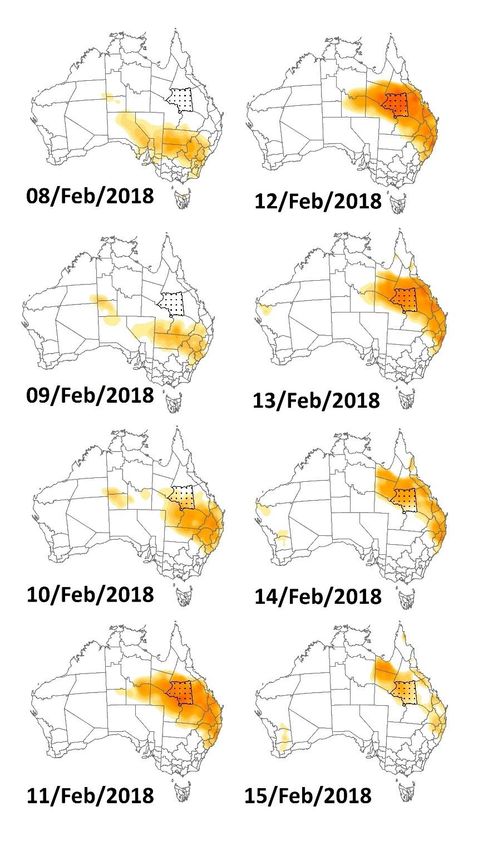
principle cities and towns displayed. The sequence of observed heatwave severity maps
for 8 to 15 February in Figure 3 shows growing heatwave severity as it moved up from
New South Wales, with peak severity over central Queensland on 12 February.
Figure 3. Observed (Day 0) EHF Severity maps, 8 to 15 February 2018. Central West weather
district (Queensland) stippled.
Throughout summer seven heatwave severity maps were issued, corresponding to
any row in Table 1.
Observed heatwaves for Longreach and Isisford shown in column 'Day0'
correspond to the values mapped in Figures 2 and 3. Forecasts shown in Table 1 are shown
with the date of issue (Date), which corresponds to Today(0). Columns labelled Day-2, Day-AUSTRALIA’S FUTURE NATIONAL HEATWAVE FORECAST AND WARNING SERVICE:
OPERATIONAL CONSIDERATIONS | REPORT NO. 374.2018
1, Today (0), Day+1, Day+2, Day+3 and Day+4 correspond to the seven heatwave service
maps (not shown) issued on that day (Date) by the Bureau.
Day(0
Date Town ) Day-2 Day-1 Day0 Day+1 Day+2 Day+3 Day+4
2018- Longrea
02-03 ch 0 0.09 -0.45 -0.75 -0.82 -0.66 -0.57 -0.43
Isisford 0 0.01 -0.55 -0.70 -0.70 -0.53 -0.46 -0.32
2018- Longrea
02-04 ch 0 -0.46 -0.74 -0.80 -0.61 -0.58 -0.46 -0.17
Isisford 0 -0.62 -0.76 -0.67 -0.49 -0.44 -0.31 -0.04
2018- Longrea
02-05 ch 0 -0.75 -0.80 -0.54 -0.50 -0.44 -0.28 0.04
Isisford 0 -0.74 -0.64 -0.46 -0.42 -0.34 -0.17 0.12
2018- Longrea
02-06 ch 0 -0.79 -0.54 -0.49 -0.45 -0.30 -0.02 0.98
Isisford 0 -0.64 -0.46 -0.44 -0.39 -0.24 0.03 0.88
2018- Longrea
02-07 ch 0 -0.51 -0.47 -0.46 -0.36 -0.11 0.39 2.07
Isisford 0 -0.44 -0.41 -0.39 -0.30 -0.06 0.54 2.19
2018- Longrea
02-08 ch 0 -0.47 -0.44 -0.33 -0.07 0.66 2.63 3.81
Isisford 0 -0.42 -0.39 -0.27 -0.01 0.74 2.39 3.24
2018- Longrea
02-09 ch 0 -0.44 -0.30 -0.02 0.86 2.66 2.66 1.98
Isisford 0 -0.38 -0.24 0.05 1.22 2.89 2.76 1.89
2018- Longrea
02-10 ch 0.25 -0.37 -0.09 0.82 2.64 2.81 2.34 1.60
Isisford 0.80 -0.31 -0.02 1.18 2.89 2.81 2.02 1.12
2018- Longrea
02-11 ch 2.29 -0.20 0.34 2.43 2.86 2.39 1.54 1.22
Isisford 3.53 -0.12 0.62 2.66 2.86 2.06 1.32 0.81
2018- Longrea
02-12 ch 3.19 0.20 2.16 3.67 3.36 2.44 1.29 0.51
Isisford 3.62 0.51 2.53 3.53 3.01 2.11 1.05 0.42
2018- Longrea
02-13 ch 2.52 2.06 3.70 3.16 2.50 1.06 0.52 0.33
Isisford 1.97 3.08 4.14 2.86 1.90 0.81 0.43 0.41
2018- Longrea
02-14 ch 1.15 3.88 3.21 2.22 1.08 0.87 0.55 0.16
Isisford 0.59 4.72 3.16 1.56 0.63 0.46 0.30 0.13
2018- Longrea
02-15 ch 0.90 2.16 1.16 0.52 0.38 0.28 0.15 0.02
Isisford 0.62 2.13 0.64 0.26 0.16 0.18 0.13 0.02
2018- Longrea
02-16 ch 0.49 1.05 0.51 0.62 0.32 0.11 -0.04 -0.20
Isisford 0.55 0.67 0.34 0.37 0.20 0.07 -0.09 -0.28AUSTRALIA’S FUTURE NATIONAL HEATWAVE FORECAST AND WARNING SERVICE:
OPERATIONAL CONSIDERATIONS | REPORT NO. 374.2018
2018- Longrea
02-17 ch 0.74 0.22 0.27 0.34 0.13 -0.11 -0.33 -0.43
Isisford 0.82 0.25 0.19 0.19 0.03 -0.17 -0.41 -0.50
2018- Longrea
02-18 ch 0.20 0.56 0.86 0.19 -0.14 -0.46 -0.63 -0.58
Isisford 0.21 0.45 0.69 0.11 -0.15 -0.46 -0.61 -0.57
Table 1. EHF Severity values for Queensland, Central West District towns of Longreach and
Isisford, 7 to 13 February 2018.
On 12 February 2018 the Bureau's heatwave service forecast an extreme heatwave (>3)
for Longreach and Isisford (Day0: 3.70, 4.14) which verified as an extreme heatwave
(Day(0): 3.19, 3.62). The long-range forecast (Day+4) issued on 8 February forecast an
extreme event (3.81, 3.24), although subsequent forecasts included lower values (lowest
2.66). The example provided in Table 1 shows the evolution of forecast guidance for the
strongest heatwave observed over Australia for the 2017/2018 warm season. In this
instance a severe/extreme heatwave worthy of community warning messages was
sustained throughout the development and easing of the heatwave event that moved into
the Central west forecast district. Further analysis is warranted for weaker heatwave events
that are closer to the recommended heatwave warning threshold (severity 1). Community
consultation/research is required to understand how warnings would be received if
communicated as a State, Weather District or Township impact event, whilst considering
the spatial characteristics of forecast skill. This consultation must also consider appropriate
warning lead-time and the development of standardised operating procedures for multi-
hazard message construction amongst partner warning agencies.
3. Multi-Agency Heatwave Warnings
Whilst the appetite from the Bureau and emergency and health services across the
jurisdictions for a national approach to heatwave warnings and messaging is clear, the
challenges of establishing a coordinated nationwide methodology in a federated system are
equally apparent. Neither emergency or health services are exclusively the control or lead
agency for heatwave across Australia's jurisdictions. Consequently, each jurisdiction is
locked into existing nomenclature and process. There is undoubtedly efficiency in
governance and systems currently in place for mitigation and response to heatwaves by
jurisdictional lead agencies. However, heat health impacts are just one consideration. Heat
related impacts on infrastructure, continuity of utilities, efficiency of transport systems and
industry impacts also require management. Contemporary governance in public policy,
including disaster management, must evolve from a hierarchical command-and-control
focus developed from central/national government-led programs focused on response and
recovery. International and intergovernmental collaboration and coordination on disaster
risk reduction, mitigation and preparedness has evolved through the United Nations
International Strategy for Disaster Reduction’s Sendai Framework. The Sendai Framework
aspires to achieve “substantial reduction of disaster risk and losses in lives, livelihoods and
health and in the economic, physical, social, cultural and environmental assets of persons,
businesses, communities and countries”. The framework places primary responsibility for
reducing disaster risks on nation states and recommends they share this responsibility with
local governments, the private sector, academia, civil society and other stakeholders
(UNISDR, 2015). The Australian Government in turn has established the National Resilience
Taskforce to reduce the impacts of natural disasters on the Australian community, including
establishing a national disaster risk information capability to equip decision-makers and
Australians with the knowledge they need to prepare for natural disasters (Ministry of
Home Affairs, 2018).AUSTRALIA’S FUTURE NATIONAL HEATWAVE FORECAST AND WARNING SERVICE:
OPERATIONAL CONSIDERATIONS | REPORT NO. 374.2018
Greater collaboration and coordination is required to change our approach to health
impacts of heatwave. Incorporation of a national heatwave warning framework to inform
clear and consistent community messages, requires new governance considerations. A
more adaptive governance must address more than Federal, State and Local Government
responsibilities. The operational partnership must include the Bureau, emergency and
health agencies, non-government, business and community sectors. Meaningful community
messaging must be mapped backward from the community we aim to inform and not focus
on existing biases and assumptions. At the international and national levels our
commitment to reducing disaster risk and providing information to help people and
communities prepare is clear. We need to listen to those communities and understand the
language and messages that makes sense to them and build a path back to the existing and
effective national heatwave warnings, adapting and flattening out our governance along the
way.AUSTRALIA’S FUTURE NATIONAL HEATWAVE FORECAST AND WARNING SERVICE:
OPERATIONAL CONSIDERATIONS | REPORT NO. 374.2018
REFERENCES
Alexander, L. V, Tapper, N., Zhang, X., Fowler, H. J., Tebaldi, C., & Lynch, A. (2009). Climate
extremes: progress and future directions. International Journal of Climatology, 29(3),
317–319. https://doi.org/10.1002/joc.1861
Black, E., Blackburn, M., Harrison, G., Hoskins, B., & Methven, J. (2004). Factors
contributing to the summer 2003 European heatwave. Weather, 59(8), 217–223.
Retrieved from
http://search.proquest.com/docview/20985311/abstract/embedded/WOY0TUJ6YL
5SGXRJ?source=fedsrch
Bureau of Meteorology. (2014). pilot heatwave forecast service. Retrieved from
http://www.bom.gov.au/australia/heatwave/index.shtml
Chen, Y., & Zhai, P. (2017). Revisiting summertime hot extremes in China during 1961–
2015: Overlooked compound extremes and significant changes. Geophysical Research
Letters. https://doi.org/10.1002/2016GL072281
Department of Human Services, & Victorian Government Department of Human Services
Melbourne, V. (2009). January 2009 heatwave in Victoria: an assessment of health
impacts. Retrieved from
http://docs.health.vic.gov.au/docs/doc/F7EEA4050981101ACA257AD80074AE8B/
$FILE/heat_health_impact_rpt_Vic2009.pdf
Gobron, N., Adams, J. S., Cappucci, F., Lanconelli, C., Mota, B., & Mélin, F. (2016). Joint
research centre copernicus climate change service (C3S) fitness for purpose (F4P)
platform. In European Space Agency, (Special Publication) ESA SP.
Hatvani-Kovacs, G., Belusko, M., Pockett, J., & Boland, J. (2015). Can the Excess Heat Factor
Indicate Heatwave-Related Morbidity? A Case Study in Adelaide, South Australia.
EcoHealth. https://doi.org/10.1007/s10393-015-1085-5
Helen A. Titley and Joanne C. Robbins. (2013). Met Office Global Hazard Map – a prototype
GIS Web Map Service for forecasting high-impact weather across the globe for the
week ahead. EMS Annual Meeting Abstracts, 10(EMS2013–256,2013), 1. Retrieved
from http://meetingorganizer.copernicus.org/EMS2013/EMS2013-256.pdf
Herbst, J., Mason, K., Byard, R. W., Gilbert, J. D., Charlwood, C., Heath, K. J., … Langlois, N. E.
I. (2014). Heat-related deaths in Adelaide, South Australia: Review of the literature
and case findings - An Australian perspective. Journal of Forensic and Legal Medicine,
22, 73–78. Retrieved from http://www.scopus.com/inward/record.url?eid=2-s2.0-
84891792363&partnerID=40&md5=11d50c1217089a88bb497aa5f05ea80f
Hudson, D., & Marshall, A. G. (2014). Extending the Bureau of Meteorology’s heatwave
forecast to multi-week timescales.
Jegasothy, E., McGuire, R., Nairn, J., Fawcett, R., & Scalley, B. (2017). Extreme climatic
conditions and health service utilisation across rural and metropolitan New South
Wales. International Journal of Biometeorology, 61(8).
https://doi.org/10.1007/s00484-017-1313-5
Kiktev, D., Sexton, D., Alexander, L., & Folland, C. (2004). Comparison of modeled and
observed trends in indices of daily climate extremes (vol 16, pg 3560, 2003). Journal
of Climate, 17(12), 2489. https://doi.org/10.1175/1520-
0442(2004)0172.0.co;2AUSTRALIA’S FUTURE NATIONAL HEATWAVE FORECAST AND WARNING SERVICE:
OPERATIONAL CONSIDERATIONS | REPORT NO. 374.2018
Kovats, R. S., & Kristie, L. E. (2006). Heatwaves and public health in Europe. European
Journal of Public Health. https://doi.org/10.1093/eurpub/ckl049
Langlois, N., Herbst, J., Mason, K., Nairn, J., & Byard, R. W. (2013). Using the Excess Heat
Factor (EHF) to predict the risk of heat related deaths. Journal of Forensic and Legal
Medicine, 20(5). https://doi.org/10.1016/j.jflm.2012.12.005
Le Tertre, A., Lefranc, A., Eilstein, D., Declercq, C., Medina, S., Blanchard, M., … Ledrans, M.
(2006). Impact of the 2003 heatwave on all-cause mortality in 9 French cities.
Epidemiology, 17(1), 75–79. Retrieved from
http://www.ncbi.nlm.nih.gov/pubmed/16357598
Mechler, R., Hochrainer, S., Aaheim, A., Salen, H., & Wreford, A. (2010). Modelling economic
impacts and adaptation to extreme events: Insights from European case studies.
Mitigation and Adaptation Strategies for Global Change, 15(7), 737–762.
https://doi.org/10.1007/s11027-010-9249-7
Meehl, G. A., & Tebaldi, C. (2004). More intense, more frequent, and longer lasting heat
waves in the 21st century. Science, 305(5686), 994–997.
Ministry of Home Affairs. (2018, April 10). Reforms to reduce impact of natural disasters
in Australia. Retrieved from The Hon Angus Taylor MP:
http://minister.homeaffairs.gov.au/angustaylor/Pages/reforms-to-reduce-impact-
of-natural-disasters-in-australia.aspx
Nairn, J., & Fawcett, R. (2014). The Excess Heat Factor: A Metric for Heatwave Intensity
and Its Use in Classifying Heatwave Severity. Int J Environ Res Public Health, 12(1),
227. Retrieved from http://www.mdpi.com/1660-4601/12/1/227
Perkins, S. E., Alexander, L. V., & Nairn, J. R. (2012). Increasing frequency, intensity and
duration of observed global heatwaves and warm spells. Geophysical Research
Letters, 39(20). https://doi.org/10.1029/2012GL053361
Perkins, S. E., & Alexander, L. V. (2013). On the Measurement of Heat Waves. Journal of
Climate, 26(13), 4500–4517. https://doi.org/10.1175/jcli-d-12-00383.1
Russo, S., Dosio, A., Graversen, R. G., Sillmann, J., Carrao, H., Dunbar, M. B., … Vogt, J. V.
(2014). Magnitude of extreme heat waves in present climate and their projection in a
warming world. Journal of Geophysical Research Atmospheres, 119(22).
https://doi.org/10.1002/2014JD022098
Russo, S., Sillmann, J., & Fischer, E. M. (2015). Top ten European heatwaves since 1950 and
their occurrence in the coming decades. Environmental Research Letters, 10(12),
124003. https://doi.org/10.1088/1748-9326/10/12/124003
Scalley, B. D., Spicer, T., Jian, L., Xiao, J., Nairn, J., Robertson, A., & Weeramanthri, T. (2015).
Responding to heatwave intensity: Excess Heat Factor is a superior predictor of
health service utilisation and a trigger for heatwave plans. Australian and New
Zealand Journal of Public Health, 6. https://doi.org/10.1111/1753-6405.12421
Tollefson, J. (2012). Heatwaves blamed on global warming. Nature, 488(7410), 143–144.
UNISDR. (2015). Sendai Framework. Geneva: UNISDR.
Xiao, J., Spicer, T., Jian, L., Yun, G. Y., Shao, C., Nairn, J., … Weeramanthri, T. S. (2017).
Variation in population vulnerability to heat wave in Western Australia. Frontiers in
Public Health, 5(APR). https://doi.org/10.3389/FPUBH.2017.00064AUSTRALIA’S FUTURE NATIONAL HEATWAVE FORECAST AND WARNING SERVICE:
OPERATIONAL CONSIDERATIONS | REPORT NO. 374.2018
Yates, A. (2013). Death modes from a loss of energy infrastructure continuity in a
community setting. Journal of Homeland Security and Emergency Management.
https://doi.org/10.1515/jhsem-2012-0048
Zia, A., & Wagner, C. H. (2015). Mainstreaming Early Warning Systems in Development and
Planning Processes: Multilevel Implementation of Sendai Framework in Indus and
Sahel. International Journal of Disaster Risk Science. https://doi.org/10.1007/s13753-
015-0048-3You can also read