Automated Extraction of Driving Lines from Mobile Laser Scanning Point Clouds
←
→
Page content transcription
If your browser does not render page correctly, please read the page content below
Automated Extraction of Driving Lines from Mobile Laser
Scanning Point Clouds

Lingfei Ma a, Tianyu Wu a, Ying Li a, Jonathan Li a,b,c*, Yiping Chen c, Michael Chapman d
a
  Department of Geography and Environmental Management, University of Waterloo, Waterloo, ON N2L 3G1, Canada, {l53ma,
t228wu, y242li, junli} @uwaterloo.ca
b
  Department of Systems Design Engineering, University of Waterloo, Waterloo, ON N2L 3G1, Canada, junli@uwaterloo.ca
c
  Fujian Key Laboratory of Sensing and Computing for Smart Cities, School of Informatics, Xiamen University, Xiamen, FJ 361005,
China, chenyiping@xmu.edu.cn
d
  Department of Civil Engineering, Ryerson University, Toronto, ON M5B 2K3, Canada, mchapman@ryerson.ca
* Corresponding author

Abstract: This paper presents a novel approach to automated generation of driving lines from mobile laser scanning
(MLS) point cloud data. The proposed method consists of three steps: road surface segmentation, road marking
extraction and classification, and driving line generation. The voxel-based upward-growing algorithm was firstly used
to extract ground points from the raw MLS point clouds followed by segmentation of road surface using a region-
growing algorithm. Then, the statistical outlier removal filter was applied to separate and refine the road marking points
followed by extracting and classifying the lane markings based on the geometric features of different road markings
using empirical hierarchical decision trees. Finally, land node structures were constructed followed by generation of
driving lines using a curve-fitting algorithm. The proposed method was tested on both circular road sections and
irregular intersections. The smoothing spline curve fitting model was tested on the circular road sections, while the
Catmull-Rom spline with five control points was used to generate the driving lines at road intersections. The overall
performance of the proposed algorithms is promising with 96.0% recall, 100.0% precision, and 98.0% F1-score for the
lane marking extraction specifically. Most significantly, the validation results demonstrate that the driving lines can be
effectively generated within 20 cm-level localization accuracy at an average of 3.5% miscoding using MLS point
clouds, which meets the requirement of localization accuracy of fully autonomous driving functions. The results
demonstrate the proposed methods can successfully generate road driving lines in the test datasets to support the
development of high-definition maps.

Keywords: HD map, driving line, mobile laser scanning, point cloud.

                                                                      Recently, mobile laser scanning (MLS) systems have
1. Introduction                                                       demonstrated their superior solutions in HD map
The digital maps particularly created for autonomous                  generation due to the high data collection rate and high
driving functions are normally called high-definition                 flexibility in large-scale urban environments. However,
(HD) maps. Compared to commercial standard maps with                  one of the most difficult tasks for HD map generation
metre-level localization accuracy, the sub-lane level                 from unordered and noisy point clouds is to extract road
accuracy of HD maps can reach 20 cm based on the                      markings and generate driving lines on complex road
report of Enhanced Digital Mapping Project released by                networks, including road curves and irregular
the U.S. Department of Transportation. HD maps provide                intersections (Seif and Hu, 2016). Road markings and
highly accurate localization and navigation services to               road driving lines regulate the traffic rules and clear
support the development of the emerging market for                    guidance for existing road users and autonomous vehicles.
autonomous vehicles (AV) (Máttyus et al., 2016). These                By estimating diriving lines, the use of HD maps can be
HD maps provide rich road information and lane                        expanded from human-readable to machine-readable and
geometry, such as road markings, road boundaries, traffic             thereby contribute to the navigation of AVs. Nevertheless,
signs, lane lines, and reference lines. Moreover, the                 the variations in point resolutions and intensities, the low
driving lines lie in between two adjacent lane lines are              contrast between road surfaces and road markings, and
elaborately depicted in HD maps, as these driving lines               the lack of consistency in MLS point clouds make the
can be regarded as the driving routes with highly precise             accurate road marking classification and driving line
localization information for sub-lane level navigation                generation very challenging (Cheng et al., 2017).
during autonomous driving (Bétaille and Toledo-Moreo,
2010).                                                                The first step of driving line generation is to extract road
                                                                      surfaces from MLS point clouds. The proposed methods
                                                                      for road surface extraction are mainly divided into 2D

Advances in Cartography and GIScience of the International Cartographic Association, 1, 2019.
29th International Cartographic Conference (ICC 2019), 15–20 July 2019, Tokyo, Japan. This contribution underwent
single-blind peer review based on the full paper. https://doi.org/10.5194/ica-adv-1-12-2019 | © Authors 2019. CC BY 4.0 License.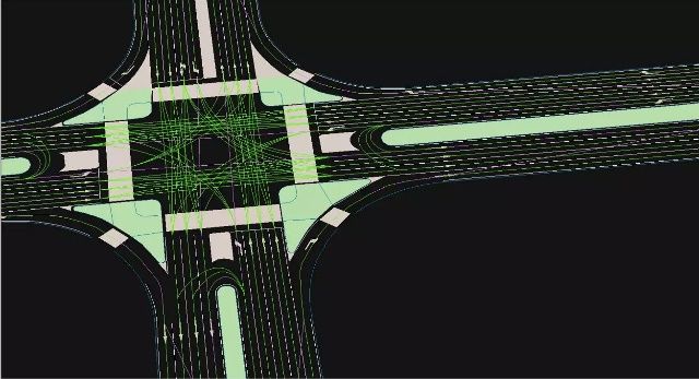
2 of 6
georeferenced image-based methods, 3D point-based support the driving line generation using the Catmull-
methods, and other input data assistance (Kumar et al., Rom spline algorithm. Furthermore, the performance of
2013 and Yu et al., 2015). Accordingly, the existing proposed algorithms is evaluated on MLS point clouds
methods for road marking extraction are mainly collected in urban environments. As shown in Fig. 1, the
categorized into two categories relying on semantic proposed algorithms in this study mainly include three
knowledge (e.g., shape) and MLS intensity properties: modules: road surface extraction, road marking extraction
georeferenced image-driven methods, and 3D point- and classification, and driving line generation. Moreover,
driven methods (Ma et al., 2018). However, it is still very two point cloud datasets containing curved roads and
challenging to propose automated algorithms that can irregular intersections, are used to test the performance of
efficiently segment 3D MLS point clouds acquired in the proposed algorithms.
large-scale urban environments into semantic objects.
The correctness and completeness of extracted road
markings have great impacts on the performance of
driving line generation. Various studies were carried out
in the past years (Zai et al., 2018, Soilán et al., 2017, and
Wang et al., 2018). Nevertheless, the prior knowledge
about LiDAR-derived control point selection makes the
accurate driving line generation very challenging (Cabo
et al., 2016).
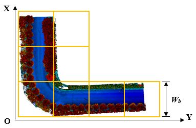
(a) (b)
(c) (d)
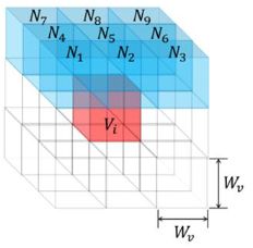
Figure 2. Voxel-based upward growing algorithm: (a) point
cloud segmented into blocks; (b) voxelization process; (c)
Adjacent voxels of Vi; and (d) upward growing process.
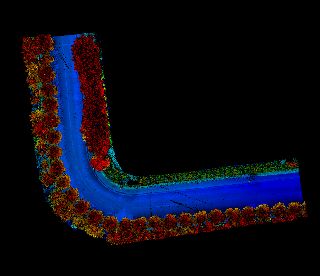
2.1 Road surface extraction
The raw point clouds collected by the RIEGL VMX-450
MLS system are in large-scale and thus lead to huge
Figure 1. Workflow of the proposed method.
computational burdens. Accordingly, the random
Therefore, developing an efficient and robust algorithm sampling algorithm packaged in CloudCompare software
to generate driving lines while precisely recording their with the predefined number of the points was performed.
geometry and coordinate information from large-scale Since the primary objective of this study is to generate
and unordered MLS point clouds, has been essentially driving lines, the non-ground points are irrelevant and
needed. In this paper, we mainly concentrate on exploring need to be removed to improve the computational
the underlying rationale and proposing a semi-automated efficiency.
algorithm for driving line generation using MLS point
A voxel-based upward growing algorithm (Yu et al.,
clouds to support HD maps.
2015) was adopted. This algorithm first partitions each
2. Method dataset into different blocks with a predefined block
width (Wb) in the XY plane, and each partition was then
This developed method can typically be perceived as a
processed separately (see Fig. 2 (a)). For each block, the
stepwise process for MLS point cloud interpretation: (1)
voxelization process divided the point cloud into an array
the input MLS point clouds are first preprocessed by the
of voxels with a predefined width Wv based on their
random sampling algorithm and a voxel-based upward
locations in the 3D space. The voxels containing points
growing algorithm to remove off-ground points; (2) road
were flagged with true, while the others were flagged as
surfaces are then extracted based on region-growing
false. Fig. 2(b) shows the result after the voxelization of
based methods; (3) a multi-threshold road marking
the point clouds. Two criteria are considered for
classification is afterward adopted to determine the
voxelization: global elevation difference (Hg) and local
optimal intensity thresholds, followed by the road
elevation difference (Hl). Accordingly, the algorithm
marking classification by using a hierarchical
identified all the voxels with Hg smaller than the
classification tree; (4) finally, the line nodes are
predefined threshold (Tg) as candidate ground voxels. As
accordingly constructed depending on the extracted road
shown in Fig. 2(c), for each candidate voxel (Vl), this
markings and road geometry information, which can
Advances in Cartography and GIScience of the International Cartographic Association, 1, 2019.
29th International Cartographic Conference (ICC 2019), 15–20 July 2019, Tokyo, Japan. This contribution underwent
single-blind peer review based on the full paper. https://doi.org/10.5194/ica-adv-1-12-2019 | © Authors 2019. CC BY 4.0 License.
3 of 6
algorithm recursively grew upward to its nine closest For road marking classification, the conditional Euclidean
neighbors (i.e. N1, N2, …, N9). If the grown voxel clustering (CEC) algorithms from the Point Cloud
contains points inside, this voxel became the new starting Library (PCL) was first employed to cluster the extracted
point and continued to grow in this pattern. This process road markings into different groups based on their spatial
terminated with the highest voxel (Vh), which has above distributions and locations. Then, as shown in Fig. 3, five
neighbors that contain points. The Hl of the origin Vl was types of road markings were classified using a
determined and compared with the predefined threshold hierarchical decision tree based on the road design
of local height difference (Tl). Therefore, only the voxels standards. Additionally, a minimum bounding box
with Hl smaller than Tl were regarded as ground voxels calculation based on PCA transformation was further
and the points within these voxels were outputted as the conducted to calculate the width and length of road
ground points, see Fig. 2(d). markings, lane markings were extracted using the
predefined geometric thresholds.
2.3 Driving line generation
First, to improve the computational efficiency, the
existing road system was abstracted with a line node
structure with the assistance of trajectory data. If a lane
centreline has an intersection with a stop line, it is
labelled as ‘exit’ lane, and its vertex is labelled as ‘exit’
node. Otherwise, the lane is labelled as ‘entry’ lane, and
its vertex is labelled as ‘entry’ node. Then, the exit point
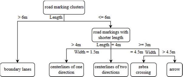
Figure 3. The hierarchical decision tree for road marking
classification.
exi was paired with the entry point enj. The interpoint mij
was determined by the location of the center point O of
The rationale of the region-growing surface extraction the intersection and the offset D. To generate smooth
was to expand the road surface points from the trajectory driving lines, the Catmull-Rom spline method was
to the curb points. The algorithm was first initialized the employed (Catmull and Rom, 1974). Based on the
seed voxels with voxels that contain the trajectory points. characteristics of the Catmull-Rom spline, the exi, enj, and
Starting from the first seed, the algorithm exhaustively mij was selected as the control point , and ,
searched their eight neighbors of the seed units along respectively. Two other control points and were
with a direction. Since road surface points are a group of selected to ensure parallels to lane Li and
points with similar elevation and have little elevation
undulation and slope changes. Based on these parallels to lane Lj. The functions that define driving lines
characteristics, the region-growing algorithm employed at the crossroad were thereby determined with the
in this study utilized four parameters: the local elevation Catmull-Rom spline functions in Eqs. (1) and (2).
difference within each voxel Hld, global height difference
∑ , 0, 1 (1)
relative to the lowest voxel (Hgd), slope difference (Sd),
and the distance of the processing voxel to its origin seed where (0≤i≤3) is defined by Eq. (2):
voxel (Ds).
2
The thresholds of these four parameters were specified as
Tld, Tgd, Tslope, and Tsearch, respectively. If the processing 2 5 3
(2)
voxel has neighbors that meet the requirements of Hld < 4 3
Tld, Hgd < Tgd, Sd < Tslope, and Ds < Tsearch, this voxel will
be marked as a road surface voxel and added to the
processing list. However, if the candidate voxel has
already been marked as road surfaces, this voxel is then 2.4 MLS system and point cloud data
ignored, while the search continues to the next seed voxel The RIEGL VMX-450 system used in this study. This
in the processing list. When the region-growing algorithm system can provide 8 mm absolute measurement accuracy
ended, the points inside the road surface voxels were with 5 mm relative precision, which can generate high-
exported as the road surface points. density point clouds near 7,000 points/m2 at normal
driving speed in urban environments. The primary
2.2 Road marking extraction and classification research target in this study is urban road scenes, as
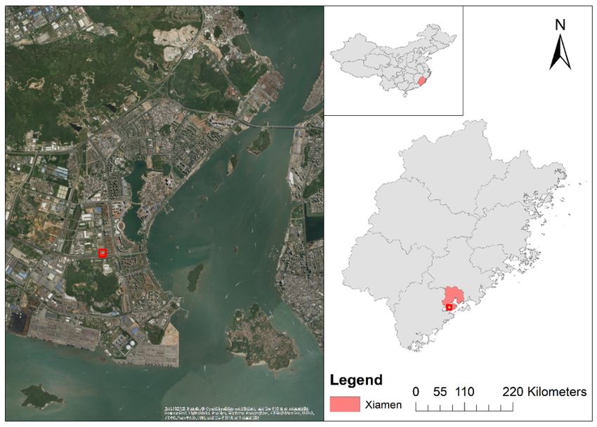
In module II, a multi-threshold road marking extraction illustrated in Fig. 4, the City of Xiamen (24°28’47.41’’N,
method was utilized to determine multiple and optimal 118°05’21.91’’E), Fujian Province, China was selected as
intensity thresholds. This algorithm first partitioned the the study area. We tested the proposed driving line
road surfaces into different bins with the width of Wbin. generation method on two MLS point cloud datasets.
Then, the intensity thresholds of each individual bin were Dataset I is a circular road section with 21,184,067 points
determined using the Otsu’s algorithm. The results after in about 70.5 m, while Dataset II is a complex road
extracting road markings contained many noisy points, intersection with 22,359,812 points with average point
which was further removed by using the statistical outlier spacing about 0.02 m. Fig. 5(a) shows curved roads and
removal (SOR) filter. irregular intersections in the collected MLS data.
Advances in Cartography and GIScience of the International Cartographic Association, 1, 2019.
29th International Cartographic Conference (ICC 2019), 15–20 July 2019, Tokyo, Japan. This contribution underwent
single-blind peer review based on the full paper. https://doi.org/10.5194/ica-adv-1-12-2019 | © Authors 2019. CC BY 4.0 License.
4 of 6

2.5 Validation                                                        effectively extracted. Moreover, such region-growing
For the road marking extraction, the confusion matrix is              based algorithm performs better in Dataset I, because the
created to analyze the classification accuracy of different           road surface of Dataset I is flatter than the surface of
road marking types based on visual interpretation. The                Dataset II, and there are fewer undulations in Dataset I.
number of correctly classified and misclassified points
were recorded in the matrix accordingly. Three criteria
that quantify the overall performance of the proposed
method, recall, precision and F1-score were calculated to
quantify the overall performance of the road marking
extraction, see Eqs. (3) - (5).

                                                                                                     (a)

                                                                                                     (b)

Figure 4. The study area in Xiamen, Fujian, China

                                                             (3)
                                                                                                     (c)
                                                             (4)

                                                             (5)

where Cp is the number of pixels that were correctly
extracted as road markings, Rcpt is the number of road
marking pixels in the reference data, and Rcrt is the
number of extracted road marking pixels by the proposed                                              (d)
algorithm.
In addition, to evaluate the accuracy of the generated
driving lines, the Buffer-overlay-statistics (BOS) method
was adopted. Buffers with a predefined distance from the
calculated driving line (X) and the reference driving line
(Q) were created, respectively. Then, the accuracy of the
driving lines was assessed by calculating the
completeness and miscoding as following:
                                                             (6)
                                                                                                      (e)
                                                             (7)      Figure 5. Experimental results in this study: (a) raw point
                                                                      clouds; (b) extracted road surfaces; (c) lane marking extraction;
                                                                      (d) driving line generation; and (e) generated HD map.
3. Results and discussion                                             Based on the length and width attributes, road markings
3.1 Driving line generation results                                   were classified into six types using the predefined
                                                                      hierarchical decision tree: boundary lanes, centerlines
The thresholds used in region-growing algorithm are                   between two directions, centerlines of one direction roads,
defined as Tld = 0.05m, Tgd = 0.8m, Tslope = π/6, and Tsearch         zebra crossing, arrow and non-road marking noises. The
= 15 m in Dataset 1, and Tld = 0.05m, Tgd = 0.95m, Tslope             overall classification accuracies for two test datasets are
= π/6, and Tsearch = 60 m in Dataset II, respectively. As             81.98% and 89.26%, respectively. Based on the road
shown in Fig. 5(b), the promising results indicate that               marking extraction result (see Fig. 5(c)), an accuracy
road surfaces from two point cloud datasets are                       assessment was thus conducted. Moreover, as shown in

Advances in Cartography and GIScience of the International Cartographic Association, 1, 2019.
29th International Cartographic Conference (ICC 2019), 15–20 July 2019, Tokyo, Japan. This contribution underwent
single-blind peer review based on the full paper. https://doi.org/10.5194/ica-adv-1-12-2019 | © Authors 2019. CC BY 4.0 License.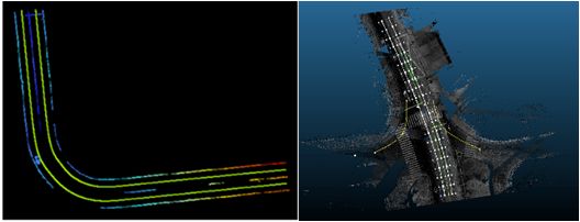
5 of 6

Table 1, the proposed algorithms for lane marking                     line generation is 5.5% and 1.5% within 20 cm buffer
extraction can deliver 100.0% precision for two input                 zones, respectively.
datasets. Additionally, the F1-score can achieve 97.6%                Based on the comprehensive analysis of the experiment
and 98.3% for each test dataset, respectively. Such high              results, it can demonstrate that the proposed method can
F1-score values for both MLS datasets have demonstrated               successfully and effectively extract and classify different
that the high performance of proposed lane marking                    kinds of road markings, and then generate the smooth
extraction method.                                                    driving lines with the promising accuracies. However, the
                                                                      proposed decision tree algorithm for road marking
     Dataset           Recall         Precision          F1-score
                                                                      classification failed to distinguish between lane marking
        I              95.3%           100.0%             97.6%       types and the complex road markings (e.g., diamonds and
       II              96.7%           100.0%             98.3%       words). For further research, we intend to propose deep
     Average           96.0%           100.0%             98.0%       learning based methods to achieve automated road
Table 1. Accuracy assessment of the lane marking extraction.          marking classification with sufficient labelled point cloud
                                                                      data.
Buffer         Dataset I                  Dataset II
zone (cm)      Completeness   Miscoding   Completeness    Miscoding   5. References
5              77.0%          23.5%       65.2%           33.7%       Bétaille, D., and Toledo-Moreo. Creating enhanced maps
10             85.8%          14.1%       87.3%           10.9%        for lane-level vehicle navigation, IEEE Trans. Intell.
15             89.6%          4.6%        91.2%           6.8%         Transp. Syst., vol. 11, no. 4, 786-798, 2010.
20             94.1%          5.5%        96.3%           1.5%        Cabo, C., Kukko, A., García-Cortés, S., Kaartinen, H.,
Table 2. Evaluation on driving line generation accuracy.               Hyyppä, J., and Ordoñez, C. An algorithm for automatic
The generated driving lines are overlapped with the raw                road asphalt edge delineation from mobile laser scanner
MLS point clouds in ArcGIS Desktop to evaluate the                     data using the line clouds concept, Remote Sens., vol. 8,
performance of driving line generation method. Fig. 5(d)               no. 9, p. 740, 2016.
presents the generated driving lines. Experimentally, four            Catmull, E., and Rom, R. A class of local interpolating
reference buffers with width of 5 cm, 10 cm, 15 cm, and                splines, Computer Aided Geometric Design, pp. 317-
20 cm are established to evaluate the performance of                   326, 1974.
proposed driving line generation algorithms. As shown in              Cheng, M., Zhang, H., Wang, C., and Li, J. Extraction
Table 2, the proposed algorithms can achieve an average                and classification of road markings using mobile laser
of 71.1 % in completeness within 5 cm-level reference                  scanning point clouds, IEEE J. Sel. Topics Appl. Earth
buffer, 86.6% in completeness within 10 cm-level                       Observ. Remote Sens., vol. 10, no. 3, pp. 1182-1196,
reference buffer, and 90.4% in completeness within 15                  2017.
cm-level reference buffer for two generated driving lines.            Kumar, P., McElhinney, C. P., Lewis, P., and McCarthy,
The values of miscoding reduce with the increased width                T. An automated algorithm for extracting road edges
of reference buffers, which reveals that the majority of               from terrestrial mobile LiDAR data, ISPRS J.
generated driving lines are located within the precision               Photogramm. Remote Sens., vol. 85, pp. 44-55, 2013.
allowable reference buffers. It can be concluded that the             Máttyus, G., Wang, S., Fidler, S., and Urtasun, R. HD
proposed driving line generation method is capable of                  maps: Fine-grained road segmentation by parsing
achieving 20 cm level accuracy with an average of 3.5%                 ground and aerial images, in Proceedings of the IEEE
miscoding for both test datasets, which meets the                      CVPR, 2016, pp. 3611-3619.
requirements of localization accuracy of HD maps. The                 Ma, L., Li, Y., Li, J., Wang, C., Wang, R., and Chapman,
accuracy reduction occurs due to the incompleteness of                 M. Mobile laser scanned point-clouds for road object
extracted road markings.                                               detection and extraction: A review, Remote Sens., vol.
Fig. 5(e) indicates a prototype of HD maps including                   10, no. 10, pp. 1531-1564, 2018.
extracted road markings and generated driving lines in                Ma, L., Li, Y., Li, J., Zhong, Z., and Chapman, M.
complex urban road environments. It is worth noting that               Generation of Horizontally Curved Driving Lines in HD
this HD map can be vectorized and overlap with other                   Maps Using Mobile Laser Scanning Point Clouds, IEEE
road information (e.g., driver behaviours) to provide                  J. Sel. Topics Appl. Earth Observ. Remote Sens, vol. 12,
highly precise road information and thus support                       no. 5, 2019.
autonomous driving functions.                                         Seif, H. G. and Hu, X. Autonomous driving in the iCity-
                                                                       HD maps as a key challenge of the automotive industry,
4. Concluding Remarks                                                  Engineering, vol. 2, no. 2, pp. 159-162, 2016.
In this paper, we have proposed a semi-automated                      Soilán, M., Riveiro, B., Martínez-Sánchez, J., and Arias,
workflow for driving line generation using MLS point                   P. Segmentation and classification of road markings
clouds to support the development of HD maps. Two                      using MLS data, ISPRS J. Photogramm. Remote Sens.,
MLS point cloud datasets including road curves and                     vol. 123, pp. 94-103, 2017.
intersections were used to test the performance and                   Wang, R., Peethambaran, J., and Chen, D. LiDAR point
robustness of the proposed algorithms. The F1-score for                clouds to 3-D urban models: A review, IEEE J. Sel.
road marking extraction can achieve 97.6% and 98.3%                    Topics Appl. Earth Observ. Remote Sens., vol. 11, no. 2,
for each test dataset. Moreover, the miscoding for driving             pp. 606-627, 2018.

Advances in Cartography and GIScience of the International Cartographic Association, 1, 2019.
29th International Cartographic Conference (ICC 2019), 15–20 July 2019, Tokyo, Japan. This contribution underwent
single-blind peer review based on the full paper. https://doi.org/10.5194/ica-adv-1-12-2019 | © Authors 2019. CC BY 4.0 License.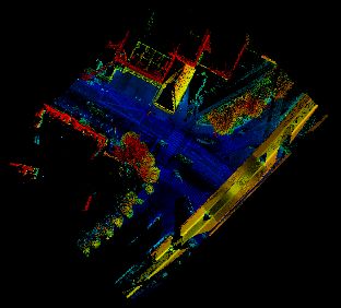
6 of 6

Yu, Y., Li, J., Guan, H., and Wang, C. Automated
 extraction of urban road facilities using mobile laser
 scanning data, IEEE Trans. Intell. Transp. Syst., vol. 16,
 no. 4, pp. 2167-2181, 2015.
Zai, D., Li, J., Guo, Y., Cheng, M., Lin, Y., Luo, H., and
 Wang, C. 3-D road boundary extraction from mobile
 laser scanning data via supervoxels and graph cuts,
 IEEE Trans. Intell. Transp. Syst., vol. 19, no. 3, pp. 802-
 813, 2018.

Advances in Cartography and GIScience of the International Cartographic Association, 1, 2019.
29th International Cartographic Conference (ICC 2019), 15–20 July 2019, Tokyo, Japan. This contribution underwent
single-blind peer review based on the full paper. https://doi.org/10.5194/ica-adv-1-12-2019 | © Authors 2019. CC BY 4.0 License.
You can also read