Beales Corner Temporary Barrier - Initial Findings Report 26/01/21
←
→
Page content transcription
If your browser does not render page correctly, please read the page content below
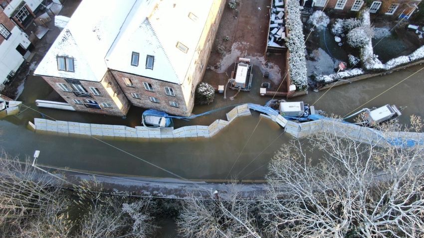
Initial Findings Report - 26/01/21
Beales Corner Temporary Barrier
Introduction
The Beales Corner temporary barrier trial started in 2006, with approximately 25
deployments to date. The barrier system consists of 210 metres of 1.25 metres high
aluminium pallet barrier. The barrier alignment runs south from high ground at the B1490
Severn Bridge approach down to a return into a property wall just beyond Millside Court.
The Environment Agency (EA) began the erection of the Beales Corner temporary barrier
System on 20th Jan 2021 in response to Storm Christoph forecasts for levels on the river
Severn to exceed 4mASD (Above Stage Datum) at the Bewdley Gauge. The full system
was completed on Friday 22nd Jan 2021 (Figure 1) and the 5.0mASD (Bewdley Gauge)
standard of service the barrier provides was reached at 18:40 that evening. At 23:45 the
defence was compromised and 19 properties behind the defence were affected.

Figure 1: Bewdley Defences - Beales Corner temporary barriers are to the north east of the River Severn.

Water levels receded on Monday 25th January 2021 and it was possible to access the site
to carry out an inspection of the defences. A drone survey was carried out on the
undisturbed defence as it became visible, and the EA West Midlands Area Catchment
Engineer undertook an initial site assessment. A representative from the barrier
manufacturer also completed a visual inspection of the site prior to the barrier being
removed.
This report documents the initial findings of the site visit and also draws on photographic
and visual accounts of the barrier before and during the breach to make initial
observations as to the likely cause.

customer service line                   03708 506 506                           floodline           03459 88 11 88
incident hotline                        0800 80 70 60                           Page 1 of 11
Beales Corner Temporary Barrier Deployment
History and Standard of Service

In spring 2003, the Environment Agency was allocated funding from the Department for
Environment, Food and Rural Affairs (Defra) to purchase plant and equipment that would
facilitate the trials of temporary flood defence barriers. Three locations along the River
Severn were initially identified as suitable, which were later extended to an additional three
including Beales Corner in Wribbenhall, Bewdley, in 2006.
The barrier trial offers a standard of service to the properties behind the barrier of 5.0m
ASD on the Bewdley gauge (this is the level at which flooding behind the barrier would
occur) and reduces risk of flooding to 19 properties on a 10% annual flood event. The
original barrier trial consisted of a short length of 1.8m and then 1.25m high barriers.
An assessment was carried out by the EA in 2014, based on an independent engineering
report, which identified risks with the continued use of temporary barriers in this location.
These risks included failure to deploy the barriers in time, operational failure, barrier sliding
and seepage. The structural analysis indicated that there is a high risk that the barriers will
move under full height loading when erected on paved surfaces, due to the lubrication
effects of flood and rain water. Due to local conditions, it has not been possible to provide
permanent fixings in the highway to support the erection of the temporary barriers or to
extend the polythene sheet to the full extent. Combined with the uneven road surface, this
contributes to a higher rate of seepage than other trial sites, and additional pumping has
been required to deal with seepage at Beales Corner. During flood events, problems with
delamination of the tarmac surface of the road, causing ‘blisters’ in the road surface have
been observed.
Due to these considerations, a total of 44 properties at Beales Corner have received
Property Flood Resilience (PFR) measures, including the 19 properties impacted by the
22nd January 2021 event. The local residents were made aware of these residual risks
associated with continued deployment; the preference of the community was that the
barriers continue to be deployed while a permanent scheme is investigated.
A 2019 assessment concluded that the standard of protection is achieved with solely the
1.25 m barrier sections due to the outflanking at higher levels, and the short 1.8m barrier
section was discontinued.
It is understood that the last time an overtopping event occurred in February 2020 it
corresponded to a level of 5.36m ASD on the Bewdley Gauge. The barriers were last
operated in March 2020, it is estimated that they have been deployed 25 times since the
trial began in 2006.

customer service line        03708 506 506                floodline      03459 88 11 88
incident hotline             0800 80 70 60                Page 2 of 11
Event Time Line (January 2021)
Timeline Summary

Monday 18th January                Beales Corner scheduled for deployment on
                                   20th January

Wednesday 20th January             Phased deployment started.

                                   13:01: Initial Flood Alert issued (031WAF108
                                   – River Severn in Worcestershire).

Thursday 21st January              Membrane attached to first section (Phase 1)

Friday 22nd January                Barrier System completed with Phase 2 in
                                   place and all membrane secured. Additional
                                   pumps and sandbags provided to residents
                                   to bolster PFR.

                                   13:14: Flood Warning (031FWFSE370 –
                                   River Severn at Wribbenhall, Bewdley)
                                   informed residents that Beales Corner will
                                   become ineffective from this evening,
                                   22/01/21.

                                   18:40: Standard of Service at 5.0mASD
                                   (Bewdley Gauge) exceeded.

                                   23:45: Barrier system compromised at
                                   5.225mASD (Bewdley Gauge)

Saturday 23rd January              05:20: Level at Bewdley Gauge rose above
                                   5.36mASD, which is estimated to be the
                                   overtop level in January 2020.

                                   08:00 An additional 10 submersible pumps
                                   ordered for EA staff to assist homeowners.

                                   12:00 Peak level of 5.435mASD recorded
                                   (Bewdley Gauge).
customer service line    03708 506 506            floodline      03459 88 11 88
incident hotline         0800 80 70 60            Page 3 of 11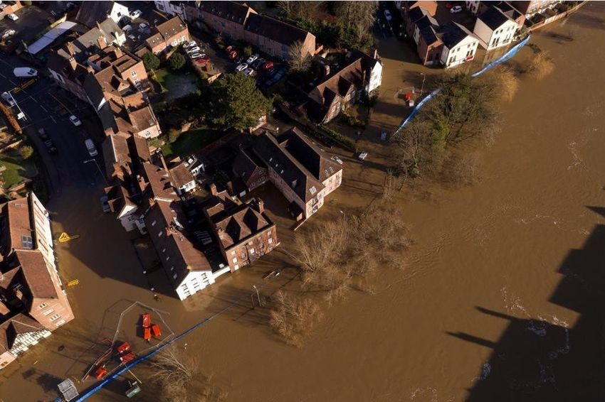
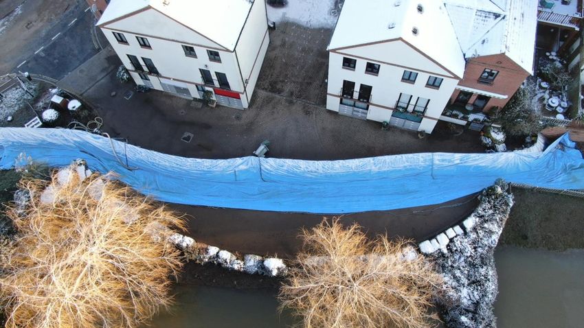
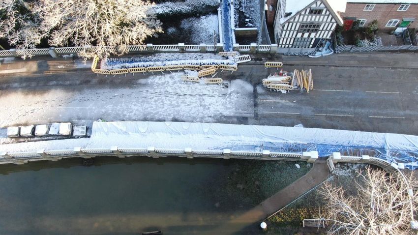
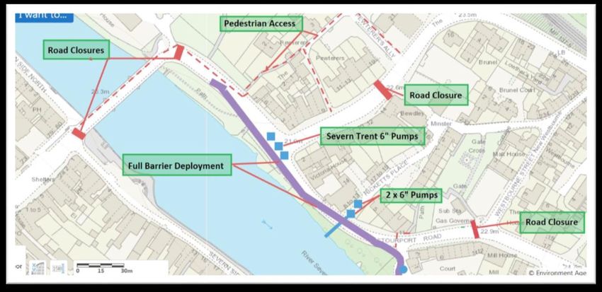
Deployment
The decision to deploy the 1.25m temporary barrier system at Beales Corner, Bewdley,
was made on Monday 18th January 2021 by the EA virtual Area Incident Room and
scheduled for the morning of Wednesday 20th January.
Deployment commenced as scheduled on Wednesday 20th January in a phased manner.
The first section (phase 1) of frame was deployed without the membrane with a Watching
Brief for the second section. This follows the normal operating procedure, ensuring the
best use of resource across the Bewdley defences and reducing the exposure of the
membrane to wind loading while the barriers remain dry.
The membrane was attached and secured to Phase 1 (outlined in figure 2) on the evening
of Thursday 21st January.

Figure 2: Bewdley temporary barriers Phase 1

The second phase (outlined in figure 3) was instructed for deployment on Friday 22nd
January at 09:30, with the full temporary barrier system complete and all membrane
installed.

Figure 3: Bewdley Temporary Barriers Phase 2

customer service line                 03708 506 506   floodline      03459 88 11 88
incident hotline                      0800 80 70 60   Page 4 of 11
Operation
The full temporary barrier system was in place by the morning of 22nd January 2021, and
as the forecast developed river levels were expected to exceed 5m ASD (Bewdley Gauge)
that evening. Residents were informed as early as possible through the EA Flood Warning
Service, allowing five hours to make preparations:
At 13:14 on 22nd January 2021, the following Flood Warning was issued – 031FWFSE370
– River Severn at Wribbenhall, Bewdley:

        As a result of recent heavy rainfall River levels have risen at the Bewdley
            gauge. BEALES CORNER barrier will become ineffective from this
        evening, 22/01/21. Flood water will overtop or outflank the Beales Corner
        temporary barrier. Flooding may affect Beales Corner, Severnside South,
         Kidderminster Road, B456, access to Bewdley Bridge including property
         on Stourport Road. Millside Court, Kidderminster and Stourport Roads,
           Greenacres Lane, Pewterers Alley, Springfield Place, Ricketts Place,
            Springfield Villas, Nunneries and Acacia Avenue. Predicted Peak:-
        Bewdley 5.2 to 5.4m Saturday afternoon 22/01/21. Our incident response
             staff are liaising with emergency services. Move possessions and
        valuables off the ground or to safety and have a bag ready with vital items
           like medicines and insurance documents. Please follow advice from
          emergency services. This message will be updated by 10am tomorrow
                              23/01/21, or as the situation changes

This was followed up by door knocking on site to ensure that the warning had been
received and to provide support where possible. The standard of service the barrier
provides (5m ASD at the Bewdley Gauge) was reached at 18:40 on 22nd January 2021.
As per the operational procedures, the two EA operations staff on site were not behind the
barrier once the Multi Agency Bronze Cell had been triggered, and no barrier performance
issues had been observed by the point that the standard of service was met. Earlier in the
day as river levels rose EA staff observed that the road surface was leaking more than had
been seen on the previous deployments, with water under pressure issuing from many
small points across the surface.
The Beales Corner temporary barrier system was compromised on Friday 22nd January
2021 at 23:45. The level at the time of breach was 5.225m ASD (Bewdley Gauge). The
temperature at time of breach was 0 degrees with heavy frost and snow overnight.
The operations staff followed the ‘Beales Corner Flood Barrier Deployment’ Construction
Phase Plan and moved to the evacuation point, notifying the Bronze Control and
confirming their whereabouts with the (virtual) EA Area Incident Room. They then returned
with the Fire and Rescue Services once the waters had settled and maintained a presence
on site supporting the community.

customer service line     03708 506 506               floodline      03459 88 11 88
incident hotline          0800 80 70 60               Page 5 of 11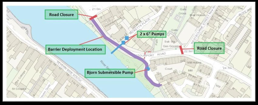
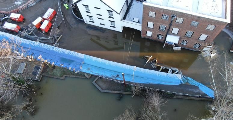
The estimated overtopping level (taken from previous deployments where property
flooding occurred) was reached at 05:20 on Saturday 23rd January 2021; this was 5-6
hours after the breach occurred. The river level peaked later that day at 12:00, reaching
5.435mASD (Bewdley Gauge).

The following photograph (figure 4) was taken on Saturday 23rd January 2021 and
illustrates the flood extent.

Figure 4: Beales Corner on Saturday 23rd January 2021

Performance Assessment
Temporary Barrier Systems can be affected by three principal modes of failure:

•   Functional Failure (overtopping, outflanking or excessive seepage)
•   Structural Failure (insufficient strength or stability)
•   Operational Failure (not installed in time)

Footage captured by remote camera just before the breach shows an inland movement in
the temporary barrier alignment (figure 5). Eyewitness accounts from residents describe
watching the barrier move just before the breach occurred.

customer service line                 03708 506 506           floodline      03459 88 11 88
incident hotline                      0800 80 70 60           Page 6 of 11
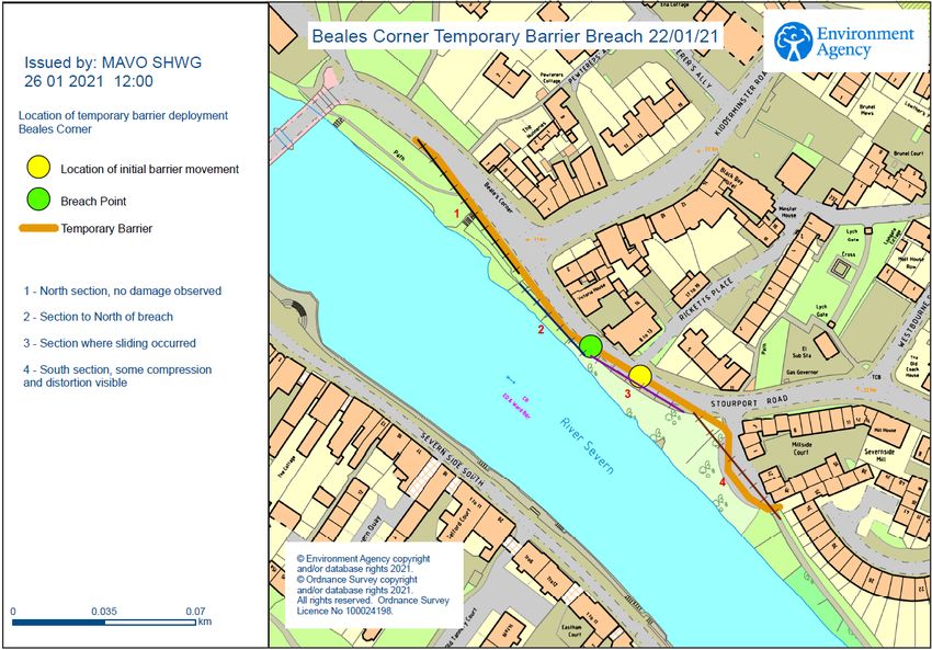
Figure 5: EA Remote Camera photograph showing inward movement of a section of barrier at the centre of the image at 23:34.

This initial movement and change in the barrier alignment captured by remote camera
suggests sliding of the barrier and indicates that structural failure may have been the
mode of failure which occurred.
Operational failure has been considered, however the team that deployed the barrier are
all trained and experienced, and the construction is methodical and checked by a qualified
engineer.
The visual site inspection has been broken down into 4 main sections:

Figure 6: plan referencing sections of defence for inspection purposes.

customer service line                    03708 506 506                        floodline          03459 88 11 88
incident hotline                         0800 80 70 60                        Page 7 of 11
Section 1 is the northern section of barrier which appeared to be on its original alignment
(see figure 7) with no visible damage until past the Beales Corner road junction:

Figure 7: Showing the top north east end of Section 1

Section 2 is the section of temporary barrier which culminates at the breach. At the point of
breach a spacer bar was observed with its weld broken and the membrane was torn. The
barriers were twisted backwards against the back of the adjacent barrier, this is likely to
have been caused by the force of the water flowing through the breach point.

Figure 8: Section 2

customer service line                   03708 506 506   floodline      03459 88 11 88
incident hotline                        0800 80 70 60   Page 8 of 11
Section 3 is comprised of barrier which had moved from its original alignment just behind
the toe of the kerb, approximately 4m inland across the road. Damage to the road service
in the form of scrape marks is most evident at the entrance to Ricketts Place, which is the
low spot in the scheme. This observation ties in with where the initial movement was
captured in Figure 5. This indicates that the slide started at this location with 1 or possibly
2 legs losing grip on the road surface and the barrier moving under load. The membrane
was damaged and the barrier deformed most at the centre of the slide where there were
no kerb or barrier restrictions to slow movement.
As the movement occurred and the barrier exerted force on each adjacent section through
the pins it appears to have stopped at the location of the breach point. Barriers are not
designed for erratic lateral tension and it is likely that the weld broke at this point and the
top section of Section 3 was washed backwards against the kerb.

Figure 9: Section 3

Section 4 showed evidence of compression and displacement at the bottom end, and bins
and other debris had struck legs damaging spacer bars and exerting pressure along the
line. The alignment remained unchanged, however some material has been washed out
and many feet were unevenly seated.

customer service line       03708 506 506                floodline      03459 88 11 88
incident hotline            0800 80 70 60                Page 9 of 11
Figure 10: Section 4

General observation of the site showed a marked deterioration in carriageway pavement
condition with gouge marks from the barrier system, stress cracks, settlement away from
the kerb and loss of surface material. Some of these issues may have been present before
the event.

customer service line     03708 506 506             floodline    03459 88 11 88
incident hotline          0800 80 70 60             Page 10 of 11
Summary of Impacts and Conclusion
As of 24/01/21 it is believed that 19 properties at risk within the 10% annual probability
flood outline were impacted due the breach. PFR measures combined with sandbags and
additional pumps previously provided by the EA were able to minimise the impacts in a
small number of properties.
From the site inspection and evidence collated prior to and after the event, it appears likely
that the barrier underwent sliding failure which lead to distortion at the furthest point of
slide, and a breach further along the line of the defences where the forces transferred by
the continuing slide were too great for the barrier spacer plate connections.
The resistance to slide is provided by the anchoring forces between the teeth under the
base plates and the ground, and the membrane and the ground. Observations on site
indicate that the friction between the teeth of the base plate and the ground may have
been reduced due to any of the following factors:

•    delamination of the road surface (allowing the surface to be stripped off),
•    water seepage through the road surface creating a buoyancy force,
•    environmental conditions on the day with freezing temperatures.

Following this initial site inspection of the abnormal barrier operation, we have engaged an
independent engineer to review the findings and, in line with normal Environment Agency
procedures, a full Post Incident Review will be completed.

    Version           Final V2
    Date              26.01.21

    Signed

    Author            Lindsey Sayner, BEng(Hons) MSc CEng(MICE)
    Role              Catchment Engineer

customer service line        03708 506 506               floodline     03459 88 11 88
incident hotline             0800 80 70 60               Page 11 of 11
You can also read