Berwick Drive Garage Site, West Bletchley Development Brief - Adopted January 2016 www.milton-keynes.gov.uk/urban-design
←
→
Page content transcription
If your browser does not render page correctly, please read the page content below
Urban Design & Landscape Architecture

                                          Berwick Drive Garage Site,
                                                      West Bletchley
                                                     Development Brief

                                        www.milton-keynes.gov.uk/urban-design

                                                Adopted January 2016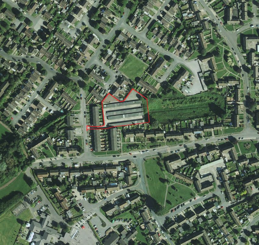
Land off Berwick Drive, West Bletchley, Development Brief

    This document has been prepared by
    Milton Keynes Council’s Urban Design
    and Landscape Architecture Team.

    For further information please contact:

    Grant Gibson
    Design and Special Projects Manager
    Urban Design & Landscape Architecture
    Planning and Strategic Transport Group
    Milton Keynes Council
    Civic Offices
    1 Saxon Gate East
    Milton Keynes MK9 3EJ

    T   +44 (0) 1908 254727
    F   +44 (0) 1908 252329
    E   grant.gibson@Milton-keynes.gov.uk

2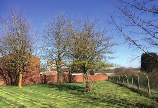
Urban Design & Landscape Architecture

Contents

SECTION 1                                        SECTION 3

INTRODUCTION                                     CONTEXT/SITE APPRAISAL

                                                 3.1   Introduction                                   8
1.1   Purpose and Scope of the Brief		       4
                                                 3.2   The Site		                                     8
1.2   Location and Ownership                 4
                                                 3.3   Surrounding Area		                            11
1.3   Structure of Brief                     4
                                                 3.4   Opportunities and Constraints		               12
1.4   Accuracy of Information		              4

		                                               SECTION 4
SECTION 2
                                                 DESIGN PRINCIPLES
POLICY CONTEXT

2.1   National Planning Policy Framework		   6   4.1   Introduction		                                13

2.2   Local Plan 		                          6   4.2   Design Principles                             13

2.3   Adopted Core Strategy		                7   4.3   Development Requirements                      16

2.4   Supplementary Planning Guidance        7
                                                 4.4   Illustrative Layout                           16
2.5   Corporate Plan                         7

2.6	Housing Strategy (June 2013)           7

www.milton-keynes.gov.uk/urban-design                                                                      3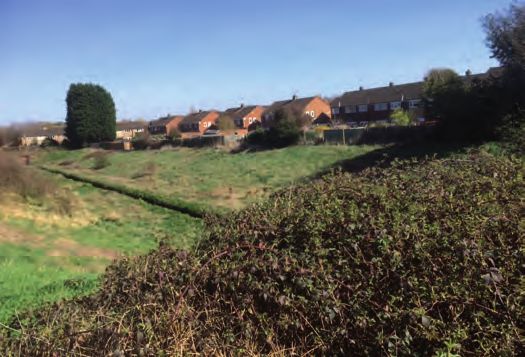
Land off Berwick Drive, West Bletchley, Development Brief

SECTION 1:                               INTRODUCTION

Milton Keynes Council wishes to appoint a Contractor to develop a former garage
site for the provision of housing for the Council on a “design and build” basis on a
site at Berwick Drive, West Bletchley.

    1.1 Purpose and Scope of the Brief                          have an important bearing on the key design principles
                                                                and parameters.
    The purpose of this document is to provide prospective      Section 4 represents the Key Design and Development
    Contractors with development and design guidance for        Principles, that should inform any development
    the development of the site. This will allow Contractors    proposals. An accompanying Parameters Plan spatially
    to submit informed proposals that respond to Council        illustrates the design principles. Section 4 concludes
    expectations for the site. The Brief has undergone          with an Illustrative Layout that adheres to the design
    consultation with a variety of stakeholders and where       principles and Parameters Plan and outlines how the
    appropriate has been amended to reflect the comments        site might be developed.
    made.
                                                                1.4 Accuracy of Information
    1.2 Location and Ownership
                                                                Descriptions of the site and or drawings contained within
    The site extends to approximately 0.39 ha (0.95 acres)      or issued in connection with this brief are for information
    and is located within the West Bletchley area of West       purposes only and the Council does not warrant their
    Bletchley Parish. The site lies at the rear of properties   accuracy. The developers should satisfy themselves
    that front Berwick Drive and Forfar Drive. Vehicular        prior to entry on the site that its boundaries are agreed
    access is off Berwick Drive. (see figure 1).                and are physically delineated and/or accurately
                                                                described in the relevant legal documentation.
    The site is currently in the freehold ownership of Milton
    Keynes Council.                                             Please note that any costs borne in responding to this
                                                                brief are entirely at the contractor’s risk and the Council
    1.3 Structure of Brief                                      are not bound to accept any tender received.

    The Brief is divided into four sections:
    Section 1 outlines the purpose of the brief, its location
    and ownership and other administrative information for
    Contractors.
    Section 2 describes the policy context of the site,
    both in terms of planning and the Council’s corporate
    objectives.
    Section 3 provides an analysis of the site itself and the
    surrounding area. A thorough understanding of this will

4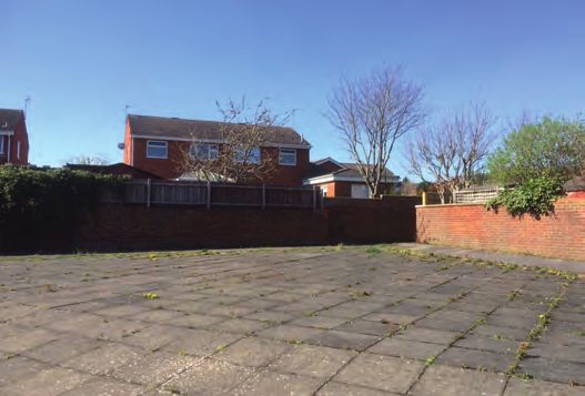
Urban Design & Landscape Architecture

                                        Berwick Drive

                                                                 Drive
                                                        Forfar

Figure 1: Site Location

www.milton-keynes.gov.uk/urban-design                                                                            5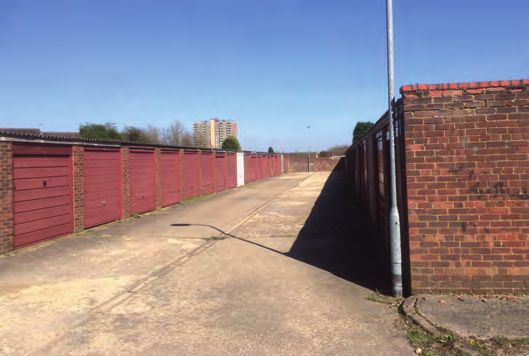
Land off Berwick Drive, West Bletchley, Development Brief

SECTION 2:                               POLICY CONTEXT

2.1	National Planning Policy Framework                         2.2 Local Plan (December 2005)

The National Planning Policy Framework (NPPF)                    The Milton Keynes Local Plan was adopted in
was published in 2012. At the heart of the NPPF is a             December 2005. The following Local Plan policies
presumption in favour of sustainable development. The            have been ‘saved’ by the Secretary of State. They
NPPF’s core planning principles include:                         remain in force until superseded by other planning
                                                                 policy documents in the Council’s Local Development
•       “always seek to secure high quality design and a
                                                                 Framework e.g. the Core Strategy & other Development
        good standard of amenity for all existing and future
                                                                 Plan Documents (DPDs).
        occupants of land and buildings;

•       encourage the effective use of land by reusing land      The site is identified in the Local Plan as lying within the
        that has been previously developed.”                     limits of development (H7). Housing development will
                                                                 be assessed against the following criteria:
The NPPF (para 50) states that: “To deliver a wide               “(i) Whether the site has been previously developed
choice of high quality homes, widen opportunities for
                                                                 (ii) Whether any buildings on the site are empty or
home ownership and create sustainable, inclusive and
                                                                 under-used and suitable for conversion to residential
mixed communities, local planning authorities should:
                                                                 use.
•       plan for a mix of housing based on current and
        future demographic trends, market trends and the         (iii) The location and accessibility of the site to jobs,
        needs of different groups in the community (such         shops and services by means other than the car, and
        as, but not limited to, families with children, older    the potential for improving such accessibility.
        people, people with disabilities, service families and
                                                                 (iv) The compatibility of housing development with
        people wishing to build their own homes)”
                                                                 existing land uses in the surrounding area

As of 6 April 2015, National Planning Policy has been            (v) Whether there is sufficient capacity in existing
strengthened to make it clear that the Government’s              infrastructure, including water supply, drainage and
expectation is that Sustainable Drainage Systems                 other utilities, and community facilities (such as schools
(SuDS) will be provided in new developments. To this             and health facilities) to serve the proposed development
effect it is expected that, where planning applications
                                                                 (vi) Whether there are any physical and environmental
are for major development, the Local Planning Authority
                                                                 constraints, such as contamination, noise and flood risk,
must ensure that SuDS are put in place, unless
                                                                 affecting the site.”
demonstrated to be inappropriate. Milton Keynes
Council will therefore determine planning applications           Policies D1 and D2 are general design policies that
in accordance with national standards and local policy,          apply borough-wide. They look at the impact of
whilst taking into account technical advice provided by          development proposals on locality and the design of
the Lead Local Flood Authority.                                  buildings.
                                                                 Policy H9 requires that for development proposals of
                                                                 5 or more dwellings a range of house sizes and types
                                                                 should be provided.”

6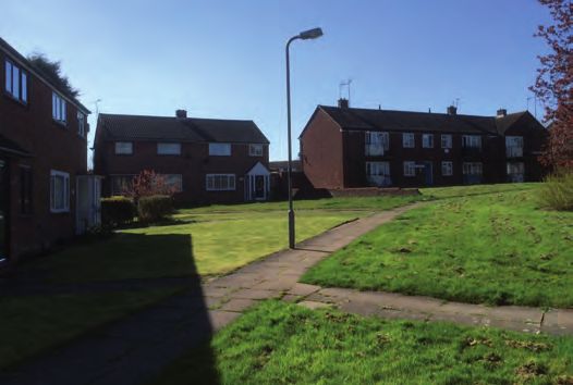
Urban Design & Landscape Architecture

2.3	 Adopted Core Strategy (July 2013)                     2.5	 Corporate Plan (2012-16)

The Core Strategy forms part of the Development Plan         The Corporate Plan sets out how the Council and its
for Milton Keynes.                                           partners will work together to achieve their collective
                                                             ambitions for Milton Keynes. It states, under 2.2
Policy CS 10 (Housing) states that: “The Council will        Theme - Living in MK, that one of the Council’s
plan to meet specific housing needs across the Borough       priorities is to “encourage the building of a mix of
including the following: affordable housing, multiple        sizes, types and tenures of homes, including social
occupancy, elderly persons, special needs, single            rented accommodation, that will meet the needs and
people, religious, ethnic or lifestyle groups.”              aspirations of Milton Keynes’ existing residents and the
                                                             new residents we wish to attract.”
Milton Keynes benefits from an innovative and strategic
approach to open space provision and surface water
                                                             2.6	Housing Strategy (June 2013)
management. In line with local policy contained within
                                                             The Council’s Housing Strategy sets out the following
the Core Strategy, all new developments will be required
                                                             Strategic Priorities to deal with the Issues that are
to ensure that flood management is planned at the
                                                             identified in the Strategy;
largest appropriate scale, providing sustainable and
                                                             1) To increase the supply of housing
strategic surface water drainage as part of a network of
                                                             2) To tackle housing conditions
multi-purpose open spaces.
                                                             3) To improve access to and affordability of housing
2.4	Supplementary Planning
      Documents (SPD)                                        A key Objective is to start a council house building
                                                             programme that will initially focus on properties for
The following Supplementary Planning Documents               older people and people with disabilities. The Strategy
(SPDs) should be considered when preparing any               also requires that housing should be built to the former
planning application for the site:                           English Partnerships Quality Standards (2007) which
• New Residential Development Design Guide (2013)            include:
• Affordable Housing (2012)                                  • Secured by Design (to design out crime);
• Sustainable Construction (2007)                            • Lifetime Homes (to make housing accessible for as
• A suite of Supplementary Planning Documents and            many people as possible);
 Guidance Notes relating to Developer Contributions          • Building for Life Silver standard (a national standard
• Milton Keynes Council’s Addendum to Parking                set by the Commission for Architecture and the Built
 Standards was adopted as SPG in 2009. It sets out            Environment and the house-building industry); Building
 the Council’s standards relating to parking provision for    for Life 12 (BLF12) has now replaced Building for Life
 residential development.                                     ‘Silver’. This in turn would be need to be assessed by
                                                              the Council’s UDLA team at a pre-planning application
                                                              stage and signed off/agreed by UDLA prior to a
                                                              planning application being made.
                                                              Schemes should achieve 9 ‘greens’ as a minimum.

www.milton-keynes.gov.uk/urban-design                                                                                       7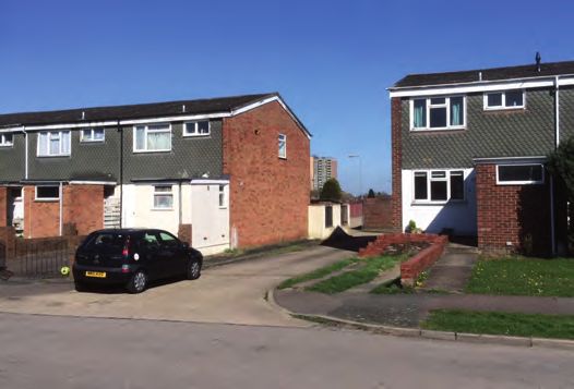
Land off Berwick Drive, West Bletchley, Development Brief

    SECTION 3:
    CONTEXT/SITE APPRAISAL

3.1 Introduction

It is important to understand the existing site and                  The properties in Berwick Drive and Forfar Drive were
surrounding area and their features, as this informs the             originally council-owned but a large number have been
layout and design principles for any redevelopment of                purchased under the Right to Buy.
the site. Figures 2 and 3 provide an analysis of the site
and its context.                                                     There are local shops at Melrose Avenue. There is
                                                                     also a local centre and community centre on the corner
3.2 The Bletchley Context                                            of Warwick Road and Whaddon Way. Barleyhurst
                                                                     Park, Rickley Park and Holne Chase Primary Schools,
The site is situated in the West Bletchley area of West
                                                                     Romans Field School, The White Spire School, Lord
Bletchley Parish which is predominantly residential
                                                                     Grey Secondary School and Milton Keynes College are
and is separated from Bletchley and Fenny Stratford
                                                                     all within walking distance of the site.
by the West Coast Main Line railway. The site lies
in the residential ‘district’ bounded in the south by
                                                                     The nearest bus stops to the site are on Whaddon Way
Whaddon Way and in the north by the A421 Standing
                                                                     and Shenley Road within 400m of the site. A medical
Way. Bletchley is an older more established area of
                                                                     centre, doctors surgery and dental practice are all within
Milton Keynes and the residential development of
                                                                     the area surrounding the site.
predominantly 2 & 3 bedroom houses including the
garage site dates back to 1950. A plan showing the
location of the Berwick Drive Garage site in Bletchley is
set out in Fig 2.

    The vehicular entrance to the site is via a narrow access road   Typical properties along Forfar drive.
    which is between dwellings along Berwick Drive.

8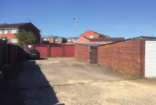
Urban Design & Landscape Architecture
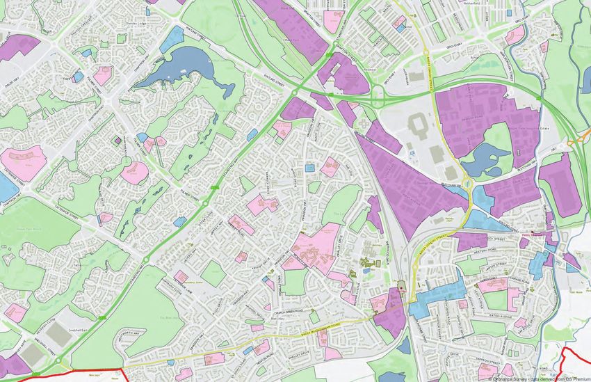
HOUSING
EMPLOYMENT
PUBLIC OPEN SPACE
LOCAL FACILITIES
EDUCATION
BUS STOP
SITE BOUNDARY
400 METERS FROM SITE
Figure 2: Surrounding Area
www.milton-keynes.gov.uk/urban-design 9Land off Berwick Drive, West Bletchley, Development Brief
3.3 Surrounding Area
3.3.1 Public Realm uilding Appearance & Heights, Setbacks and
3.3.3 B
Edge Conditions
The site is located within a network of existing
residential streets, which have carriageways between Existing development bordering the site is 2 storey
4m and 5.9m wide, the properties have large set backs terraced and semi-detached housing. The houses are
and 1.5m footways. However as this site sits within an a mixture of buff, red brick and tiled cladding with tiled
existing block and isn’t proposed to be a through route, hipped roofs.
a ‘tighter’ urban form would not impact on the character
of the wider context because the development would be Along Berwick Drive, buildings are set back 5 to 7
largely hidden from public view. metres from the pavement. Front boundary treatments
vary and include low brick walls, and hedges. In
3.3.2 Land Uses some cases, gardens are open plan with no boundary
treatment and utilised for on plot parking provision.
The site is located within a residential block. It is
bordered on the north by the rear of properties that front Along Forfar Drive, buildings have a larger set backs
Inverness Close and Orkney Close, on the west by the ranging from 10 metres to as much as 30 metres in
rear of the Berwick Drive, and on the south by the rear places providing wide tree and shrub planted grass
of dwellings that face Forfar Drive. verges between property boundaries and the road.
To the east of the site is a large green space containing
an open water channel running east to west.
The channel is culverted at both ends and runs under
the site.
View east from the site over large green space containing the
open water channel.
The site comprises of residents garage parking area. Rear boundary of existing dwellings on Orkney Close backing onto site
10Urban Design & Landscape Architecture
3.4 The Site Itself 3.5 Opportunities and Constraints
The site itself is a residential parking area consisting of The preceding sections of the development brief provide
85 garages which sits on a total area of approximately an appraisal of the site and its context to help inform the
0.39 ha. Accessed off Berwick Drive by a long narrow following opportunities and constraints:
drive with an adjacent footpath.
Opportunities
The site is bordered on the north, west and south sides
by the rear garden walls and fences of the surrounding • The site is close to bus stops and existing shops
houses and on the east side by a green open space with • Brownfield site that is readily developable
a water channel running through the centre. • The site is reasonably flat
• Existing vehicular access is present
The capacity of this adjoining site serves as a flood • Surrounding properties have fairly long back gardens
alleviation system to a wider drainage network. backing onto the site. This provides sufficient distances
from the site to facilitate infill development
The garages will require demolishing as part of the • No known existing ecological constraints
re-development of the site and attention is drawn to the
fact that roofs may contain asbestos. Constraints
• Vehicular access off Berwick Drive will require careful
A footpath crosses the site accessed via several design consideration
narrow pedestrian alleys. Some alleyways will need to • Existing pedestrian through routes to be incorporated
be extinguished and ownership of land transferred to into the street layout.
adjoining properties. None of the footpaths that lead into • Two footways will require extinguishing and access to
or traverse the site are public highway or public rights rear gardens provided via a lockable gated access.
of way. However, it is considered that the connecting • Private rear garden access of existing properties
nature of the through route that the footpath provides bordering the site requires careful consideration to
will need to be incorporated into the street layout of the avoid undesirable alleyways
development. • Relationship to on site culvert and adjacent water
channel needs careful consideration.
• Demolition required
• Likely asbestos.
• Some level changes across the site
Side boundary of existing dwellings back onto the site Road serving three rows of garages
www.milton-keynes.gov.uk/urban-design 11Land off Berwick Drive, West Bletchley, Development Brief
N
BE RW IC K DR IVE
FRONTS OF BUILDINGS
EXISTING PEDESTRIAN ACCESS
TO THE SITE
EXISTING VEHICULAR ACCESS
TO THE SITE
SITE BOUNDARY
FO RFAR DR IV E PEDESTRIAN ROUTE
WATER CULVERT
LAND USES
RESIDENTIAL 2 STOREY
EXISTING GARAGE UNITS
Figure 3: Site Analysis
12Urban Design & Landscape Architecture
SECTION 4: DESIGN PRINCIPLES
4.1 Introduction 4.2.4 Building Heights
The size and shape of the site and length of rear
This section outlines the principles relevant to the gardens of surrounding properties suggest that new
design and development of the site. A Parameters housing will predominantly be of two stories in height.
Plan accompanies the principles which serves where
appropriate, to spatially represent the key design 4.2.5 Vehicular Movement
principles. An illustrative layout is also included that Access should be provided to the site via the existing
reflects the design principles and parameters plan. driveway off Berwick Drive.
Provision should be made for an appropriate turning
4.2 Design Principles area within the development site.
Roads should be built to MKC adoptable standards. If
4.2.1 Structure/Layout this is not achievable and a private road is proposed,
The layout of the development should ensure that then provision for refuse collection point should be
there is a clear public front with entrances and a secure provided within 30 metres of dwellings. The refuse
private back. The layout should not result in ambiguous vehicle should be able to get within 25 metres from the
space that is not clearly public or private or public space collection point.
that is not properly overlooked / addressed.
For infill garage sites such as this one, the layout will 4.2.6 Pedestrian and Cycle Movement
also be informed by the need to protect the amenity of Footways should be provided to the front of the
existing surrounding properties which generally means proposed dwellings.
creating the maximum back-to-back distances possible.
4.2.7 Parking
4.2.2 Building Lines Car parking provision must be in accordance with Milton
Development should be set back a minimum of Keynes Council’s Parking Standards in force at the time
2.0m behind front gardens as long as acceptable back- of planning submission.
to-back distances can still be achieved. The developer is advised to contact the Council’s
Highways Engineer (Development Management) at an
4.2.3 Frontages early stage with regard to car parking requirements.
The internal street and associated public open space Parking spaces should be provided adjacent to the
must be overlooked by development. All front elevations dwelling, either to the side or to the front. (Please see
to this street should have active frontages (an ‘active section 4.4 for additional information on parking)
frontage’ is a building facade that responds positively
to the street and particularly at the ground floor
includes uses, entrances, and windows that generate
activity, which then improves safety on the street).
Side elevations to the street should have an animated
frontage (an ‘animated frontage’ is a building facade
that responds positively to the street and particularly at
the ground floor provides visual activity and potential for
overlooking but with no required direct access onto the
street).
www.milton-keynes.gov.uk/urban-design 13Land off Berwick Drive, West Bletchley, Development Brief
N
BE RW IC K DR IVE
BUILDING LINE
VEHICULAR ACCESS TO INDIVIDUAL DWELLINGS
PEDESTRIAN ACCESS IN TO THE SITE
VEHIICULAR ACCESS IN TO THE SITE
FOOTPATH
WATER CULVERT
ACTIVE FRONTAGE
ANIMATED FRONTAGE
(does not necessarily require ground floor doors but does
include windows that allows overlooking of the public realm.)
SITE BOUNDARY
FO RFAR DR IV E BUILDING (2 STOREY)
SETBACK (1.5 - 2m)
PRIVATE REAR GARDEN
GATED PRIVATE REAR ACCESS
Figure 4: Parameters Plan
14Urban Design & Landscape Architecture
4.2.8 Detailed Design Appearance 4.2.10 Boundary Treatments
While the buildings will largely be hidden from view Public and private space should be clearly demarcated
from the surrounding existing street network, careful through the use of front boundary treatments.
consideration to the appearance of the buildings still Low hedges or shrub planting would be an appropriate
needs to be applied. boundary treatment to delineate the interface between
The neighbouring dwellings provide few positive design the access road and front gardens to the proposed
cues (other than roof form and materials) to inform the houses.
character of the development. Examples of orange,
yellow and red brick and/or cladding and white render Because new housing will predominantly back onto
with tiled hipped roofs can all be found on adjacent the rear of existing housing, rear boundaries will
properties. Consequently, there is scope for designers to already be in existence. However, if these are deemed
adopt a contemporary approach to architectural design, inappropriate height, material, or poor state of repair
particularly where this would help to achieve Level 4 of they will be required to be replaced.
the Code for Sustainable Homes.
Boundaries facing the public realm should be
Regardless of what architectural style is employed, constructed of brick. If new rear / side boundaries are
buildings should be well proportioned, and be needed, a 1.8m solid structure is required.
constructed of high quality materials.
4.2.11 Safety and Security
4.2.9 Landscaping
The developer must consult with the Crime Prevention
Development proposals should be accompanied by a Design Advisor (CPDA) at an early stage in the design
plan illustrating indicative landscape principles for the process: initially, regarding design and layout and
site. subsequently, regarding any additional physical security
or community safety requirements.
Landscaping should be used wherever possible to
reduce the impact of blank side and rear boundary Developers should contact Brian Rodger 01908 257991
fences or walls, blank gable ends and to soften the brian.rodger@milton-keynes.gov.uk to discuss safety
appearance of parking courts. Streets should be defined and security issues.
with public amenity street trees; these must include a
number of ‘special/landmark’ trees to add character and
help create a sense of place
www.milton-keynes.gov.uk/urban-design 15Land off Berwick Drive, West Bletchley, Development Brief
4.2.12 Scheme Design 4.3 Illustrative Layout
The following design requirements should be met by the Using the design principles and the Parameters Plan
scheme: outlined in the previous sections, an illustrative layout
• General Needs: option (Fig 5) has been drawn up.
1 Bed/2 Person homes – 51m2
2 Bed/3 Person homes – 66m2 The layout indicates that a maximum of sixteen units
2 Bed/4 Person homes – 77m2 with life time home specification comprising of:
3 Bed/5 Person homes – 93m2 Nine 2 bed houses, six 2-bed flats and one 2 bed
4 Bed/6 Person homes – 106m2 wheelchair compliant bungalow, all with on plot parking,
could be accommodated on the site.
• Wheelchair Standard Bungalows:
1 Bed/2 Person homes – 55 – 60m2 An area for a residential car park that can accommodate
2 bed/3 Person homes – 70 – 75m2 11 wheelchair compliant spaces has been suggested on
3 bed/ 5 Person homes – 90 – 95m2 Forfar Drive to deal with the displaced parking provision
for existing residents who currently utilise the garage
• The scheme must comply with the former English site for parking. This provision is proposed to enable
Partnership’s Quality Standards 2007 (which successful development of the site without impacting on
incorporates Secured by Design and Lifetime the needs of the existing residents.
Homes) with the following revisions:
• BLF12 with a minimum of 9 ‘greens’ The illustrative layout provides an examples of how the
• Level 4 of the Code for Sustainable Homes as a site could be developed. Developers are encouraged to
minimum come up with their own design solutions, based on the
• MKC Residential Design Guide design principles and the parameters plans outlined in
the development brief.
• An Automatic Water Suppression System (i.e. a
domestic fire sprinkler system) will be required in
each home together with a firm alarm and detection
system linked to a remote 24 hour call centre in
line with the recommendations of the Chief Fire
Officers Association as set out in their guidance “A
GUIDE TO AUTOMATIC WATER SUPPRESSION
SYSTEMS (AWSS) AND THEIR PRACTICAL
APPLICATION”. It can be obtained at the following
address: http://www.cfoa.org.uk/11543 This item
would be in addition to and not a replacement for
the normal requirements of the Building Regulations
• A local authority building control 12 year social
housing warranty will be needed
• Bungalows should be built to Wheelchair Standard
as per the ‘Wheelchair Housing Design Guide’
second edition by Stephen Thorpe and Habinteg
Housing Association.
16Urban Design & Landscape Architecture
N
NEW TREES TO BE PLANTED
SITE BOUNDARY
HOUSING (2 STOREY)
BIN STORE
BICYCLE STORE
PRIVATE REAR GARDEN
VISITOR PARKING
ALLOCATED PARKING
GATED REAR GARDEN ACCESS
BE RW IC K DR IVE
2 Bed x2
2 Bed
2 Bed
alow
2 Bed
2 Bed 2 Bed bung
x2
2 Bed
x2
2 Bed
2 Bed
2 Bed
Bed
2 Bed 2
2 Bed
FO RFAR DR IV E
Figure 5: Illustrative Layout
50m
www.milton-keynes.gov.uk/urban-design 17Land off Berwick Drive, West Bletchley, Development Brief
4.4 Development Requirements 4.4.4 Topography
4.4.1 Building for Life 12 The site is relatively flat, however, there are two raised
triangular areas and a footpath that runs through on the
Development proposals should be assessed against
north of the site , which sit approx.1m-1.5m higher than
Building for Life 12 (http://www.builtforlifehomes.org/go/
the rest of the garage site.
building-for-life-12) at the pre-planning application stage.
The culverted drain that runs through the site will also
This assessment should be signed off by the Council’s
require careful consideration.
Urban Design & Landscape Architecture team, prior to a
planning application being submitted. 4.4.5 Arrangements for Visiting the Site
4.4.2 Archaeology and Conservation
The developer shall be deemed to have visited the site
prior to submitting its tender and to have acquainted
Since the site is currently being used for garages
itself with means of access, the nature of the work
there are no concerns with regard to archaeology and
to be executed, the nature of the site and all other
conservation.
circumstances affecting the execution of the works
4.4.3 Ecology such as supply of and conditions affecting local labour,
carriage, haulage, unloading, scaffolding and the like.
Since the site is currently being used for garages there No claim will be allowed on account of any omission or
are no concerns with regard to ecology. There are no error arising from the lack of knowledge of such matters.
trees or bushes that would provide a suitable habitat
4.4.6 Site Investigation
to wildlife that would lead to development restrictions
and/or any delays. However, as the site is adjacent to
The site has a hard-standing surface with some
a green space and water course, the developer would
garages. The British Geological Survey Maps show that
need to carry out an ecological survey and impact
the soil is MK Drift of Till Mid Pleistocene underlain by
assessment before applying for planning permission.
Oxford Clay.
Local Plan Policy NE3 on Biodiversity Enhancement has
The site is not in an area where a Geological Radon
the objective of achieving positive gains for biodiversity
Assessment will be required for new build.
in the design of new development. All new residential
development exceeding 5 dwellings will be required to
There is no other environmentally significant issue in
incorporate proposals to enhance biodiversity.
the Council’s databases. The site would appear to be
very simple geologically and in terms of any pollution/
New buildings provide many opportunities for wildlife
contamination issue. The developer is to make all/
with benefits for biodiversity and the building occupiers.
further investigations as necessary to ensure a suitable
Specialist boxes or spaces are available (for example
knowledge of the existing site conditions sufficient to
bird/bat bricks, swallow nest cups and sparrow
complete the works
terraces). Elements such as climbing plants can create
habitat; enhance the visual appearance of buildings as
well as providing cooling, insulation and microclimate
moderation.
18Urban Design & Landscape Architecture
4.4.7 Existing Mains/Services 4.4.9 Sustainable Urban Drainage Systems (SuDS)
The developer must ascertain for itself the location and When making planning applications it is essential that,
availability of main services, sewers etc. and shall allow to get the best results, the integration of water and
for charges and costs in connection. SuDS options are considered early in the site evaluation
The developer shall be responsible for determining the and planning process, not just at the detailed design
runs of existing services and drainage and shall be held stage. Full consideration of SuDS at the pre-application
liable for any damage they may sustain as a result of and outline stage is important to ensuring surface water
the works. The developer shall allow for all necessary management is fully integrated into the development,
diversions of existing services. leading to an effective drainage design, providing
multiple benefits and with costs considered from the
outset. Developers will need to submit a detailed Flood
4.4.8 Contamination
Risk Assessment (FRA) with any planning application
for development of the site. Sustainable drainage
The developer is to make further investigations as
will be required to deal with surface water run-off on
necessary to ensure a suitable knowledge of any
site. Measures that could be incorporated include
existing contamination sufficient to complete the works.
green/brown roofs, rainwater harvesting systems,
The developer’s attention is drawn to the fact that the
permeable pavements, and filter strips and swales.
existing garages might have asbestos roofs and will
Further guidance and information can be found in the
require specialist handling during demolition.
“Milton Keynes Council Surface Water Drainage; Local
Guidance for Planning Applications”, which is available
on the Council’s website.
A culverted water channel currently runs from west to
east under the site. This opens onto and runs through
the greenspace to the east. This space acts as a
balancing pond that intentionally floods in times of high
rainfall. Development proposals for the site should note
that existing maintenance and future access to both
the culverted channel and the greenspace must be
considered and proposals must not reduce capacity or
hinder access.
www.milton-keynes.gov.uk/urban-design 19Urban Design & Landscape Architecture
Planning and Strategic Transport Group
Milton Keynes Council
Civic Offices
1 Saxon Gate East
Milton Keynes, MK9 3EJ
T +44 (0) 1908 254727
F +44 (0) 1908 252329
E urban.design@Milton-keynes.gov.uk
www.milton-keynes.gov.uk/urban-design
Available in audio, large print,
braille and other languages
01908 254836You can also read