Bicycle and Pedestrian Master Plan - Adopted in 2003 Revised in 2018 and 2021 Adopted by Selectboard on May 17, 2021 - Town of St. Albans, VT
←
→
Page content transcription
If your browser does not render page correctly, please read the page content below
St. Albans Bicycle and Pedestrian Master Plan

            Bicycle and Pedestrian
                 Master Plan
                                                    Adopted in 2003
                                                Revised in 2018 and 2021

                                      Adopted by Selectboard on May 17, 2021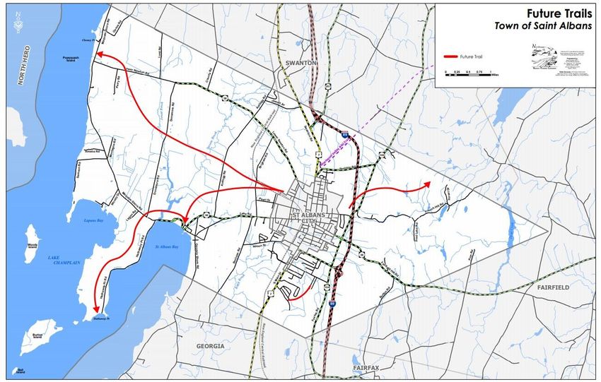
St. Albans Bicycle and Pedestrian Master Plan

ACKNOWLEDGEMENTS

2021 Selectboard
Selectboard Member & Chair, Brendan Deso
Selectboard Member & Vice Chair, Jessica Frost
Selectboard Member, Erin Creley
Selectboard Member, Bryan DesLauriers
Selectboard Member, Jonathan Giroux

2021 Planning Commission
Planning Commission Chair, Casey Toof
Planning Commission Vice Chair, Anne Pomeroy
Planning Commission Clerk, Sarah Hadd
Planning Commissioner, Al Voegele
Planning Commissioner, Hannah Rounds

The Town of St. Albans Selectboard would like to acknowledge and thank the community for their
participation and valuable input on the Bicycle and Pedestrian Master Plan. The writing of the Bicycle
and Pedestrian Master Plan could not have been accomplished without the hard work of the Planning
Commission members and many others. The Bicycle and Pedestrian Master Plan was written for and
belongs to the community of St. Albans. Bicycling, walking, and community participation are vital for
a vibrant and beautiful St. Albans.
St. Albans Bicycle and Pedestrian Master Plan

Table of Contents
CURRENT BICYCLE AND PEDESTRIAN REQUIREMENTS IN THE UNIFIED
DEVELOPMENT BYLAWS ......................................................................................................... 3
    Table 1: Recent Planning Studies…………………………………………………………….3
    Map 1: Existing Sidewalk Network ........................................................................................ 4
LAND USE, ORIGINS, AND DESTINATIONS ........................................................................... 5
    Table 2: Public Facilities & Utilities…………………………………………………………5
EXISTING NEEDS AND FUTURE OPPORTUNITIES............................................................... 6
  Facility Types .............................................................................................................................. 6
  Design and Location Guidelines ................................................................................................. 7
    Figure 1 - Modular Facility Design Schematic for Multi-Use Pathways and Sidewalks ....... 7
PROPOSED FUTURE NETWORK............................................................................................... 8
    Table 2: Priority Sidewalk and Multi-Use Pathway Projects.................................................. 8
  Bicycle and Pedestrian Plan Costs ............................................................................................ 12
    Table 3 - Estimated Project Costs: ........................................................................................ 12
  Local Capital Planning .............................................................................................................. 13
  State and Federal Grants ........................................................................................................... 13
  Town Standards and Planning ................................................................................................... 13
  IMPLEMENTATION................................................................................................................ 14
    Map 3: Priority Bicycle and Pedestrian Infrastructure ......................................................... 15
    Map 4: Long Range Trail Planning....................................................................................... 16

Page | 1
St. Albans Bicycle and Pedestrian Master Plan

INTRODUCTION

The Town of St. Albans is likely to realize substantial health benefit and economic value from a
highly connected and well-designed recreational pedestrian and bicycle network. Evidence for
the added value will most apparent in a larger Grand List, more visitors, greater recreational
opportunity, more equitable access to community assets, and an improved local economy.
Sidewalks, multi-use pathways, and trails are prioritized based on their recreational value,
connectivity, and equitable access to community assets.

This plan replaces all previous plans. St. Albans and the surrounding region have a renewed
focus on recreation and non-motorized transportation, since creation of the 2003 plan and
adoption of the A-76 road standards. The 2003 Sidewalk Master Plan, development review, and
updated public works specifications support the bicycle and pedestrian improvement goals for
development subject to review under Act 250 9(L) criteria.

The Novel Coronavirus (COVID-19) pandemic of 2020, as well as, the direction of health care
reform over the past decade have further highlighted how important local recreational
infrastructure is for community health, both physical and mental. The American Planning
Association expresses in their 2015 literature review entitled “The Benefits of Street-Scale
Features for Walking and Biking” that increased community physical activity and improvements
in mental health are some of the top co-benefits of improving and developing bicycle and
pedestrian infrastructure.

This plan includes an assessment of the present needs, existing infrastructure and appropriate
facility alternatives for future investments. Connecting the Collins Perley Sports Complex to the
Missisquoi Valley Rail Trail will provide the catalyst needed to connect the Town of St. Albans
with the City of St. Albans and the surrounding region that will encourage and facilitate more
recreational biking and walking.

The Town of St. Albans has a limited amount of pedestrian infrastructure including sidewalks,
multi-use paths, and trails. The existing bicycle and pedestrian network is shown on Map 1 and
is limited to a few commercial frontages along US Route 7 and isolated within various
neighborhoods. The adjacent City of St. Albans’ pedestrian network, shown on Map 1, has
numerous opportunities to extend into the Town of St. Albans and increase possible walking
options. A goal of the 2003 Sidewalk Master Plan and the 2018 Bicycle and Pedestrian Master
Plan was to expand our sidewalks radially from the City’s network into the Town to capture
higher density residential and commercial areas. There have been several recent planning studies
that reviewed specific locations for sidewalks and multi-use facilities. These reports and studies
were integrated into this Master Plan and are listed below in Table 1. There has been 18 years of
planning with little forward momentum on achieving these connectivity goals. The plan revision
shifts the priorities of the 2018 Master Bicycle and Pedestrian Master Plan to promote a more
expansive bicycle and pedestrian infrastructure.

Page | 2
St. Albans Bicycle and Pedestrian Master Plan
Study Year Location
From the St Albans Town Education Center along the St. Albans State Highway
Feasibility Proposal for a
2020 with an at-grade crossing near Thorpe Avenue extension to the Collins Perley
Multi-use Path
Sport and Fitness Center
Town of St. Albans Bicycle
2018 Throughout the entire community.
& Pedestrian Master Plan
Conceptual Planning and
From the Bellows Free Academy using various streets with a below-grade
Feasibility Study
2014 crossing between Thorpe Avenue and Thorpe Avenue extension under St. Albans
for Bicycle and Pedestrian
State Highway to the Collins Perley Sport and Fitness Center
Facilities
Road Safety Audit Review 2016 Surrounding the VT Route 36 / Georgia Shore Road intersection
I-89 exit 19 / St Albans
Surrounding the I-89 exit 19 / St. Albans State Highway / VT Route 104
State Highway / VT 104 2009
intersection
Intersection Scoping Study
VT Route 104 Corridor
2005 Along VT Route 104 in Northwestern Vermont
Study
Town of St. Albans
2003 Throughout the entire community
Sidewalk Master Plan
CURRENT BICYCLE AND PEDESTRIAN REQUIREMENTS IN THE UNIFIED
DEVELOPMENT BYLAWS
Currently within the Unified Development Bylaws sidewalks are required in the north and south
Growth Centers. However, only minimal bicycle infrastructure is explicitly required within the
Unified Development Bylaws. There are some keys sections of the Unified Development Bylaws
where sidewalks, bicycle infrastructure, and or trails are suggested, required, or recommended.
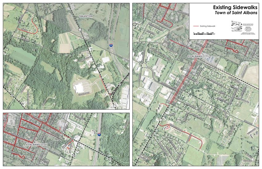
Page | 3St. Albans Bicycle and Pedestrian Master Plan DRAFT - May 26, 2021 Map 1: Existing Sidewalk Network Page | 4
St. Albans Bicycle and Pedestrian Master Plan

LAND USE, ORIGINS, AND DESTINATIONS
Trip generation of bikers and walkers has a high potential in the greater St. Albans community.
Our compact suburban neighborhoods surround the City have a great potential number of bikers
and walkers when linked with existing locations that act as origins and destinations for bikers
and walkers. When we link the origins and destinations in the City with the City’s existing
sidewalk network to our surrounding neighborhoods and our two Growth Centers, the potential
user volume is high. The list below and on Map 2 portray some important origins and
destinations for bikers and walkers in the Town of St. Albans and the City of St. Albans.

Commercial/Service                                 Public Recreation
Walmart                                            St Albans Bay Park
Price Chopper                                      Cohen Park
Hannafords                                         Collins Perley Sports and Fitness Center
Food City                                          Hard’ack Recreation Area
St. Albans Bay Store                               Taylor Park
Downtown area in St. Albans                        St. Albans City Pool
Swanton Road commercial strip                      Kill Kare State Park
North Main Street commercial strip                 St. Albans Town Forest
South Main Street commercial strip                 Missisquoi Valley Rail Trail
Lake Road commercial area
                                                   Commercial Recreation
Employment                                         Duke’s Fitness Center
Former Energizer Plant Property                    Branon’s Pool
Mylan                                              St. Albans Bay Marina
Ben & Jerry’s                                      Planet Fitness
Peerless Clothing
Northwest Correctional Facility                    Schools
St. Albans Industrial Park                         St. Albans Town Education Center
Northwest Medical Center                           Bellows Free Academy
Franklin Park West area                            Community College of Vermont
St. Albans Cooperative Creamery                    Vermont Technical College (Congress & Main)
I-89 exit 20 vicinity (northern growth center)     ~30 Day Care Centers
I-89 exit 19 vicinity (southern growth center)     Vermont Adult Learning
                                                   S OAR
Government
St. Albans Town Hall                               Housing
City Hall                                          Clyde Allen Drive neighborhood
US Post Offices                                    Eastview Drive neighborhood
US Citizens and Immigration Service                Harbor View Drive neighborhood
Park and Ride Lot (VT Route 104 / VT Route 36)     Hill Farm Estates neighborhood
Park and Ride Lot (Collins Perley Sports Center)   Lake Road neighborhoods
Park and Ride Lot (Hannafords)                     Prospect Hill Road neighborhood
                                                   St. Albans Bay village area
                                                   Pearl Street neighborhood
                                                   Thorpe Avenue extension neighborhood
                                                   Nason Street neighborhoods

Page | 5
St. Albans Bicycle and Pedestrian Master Plan
EXISTING NEEDS AND FUTURE OPPORTUNITIES
Existing needs have been identified based on a review of easily identifiable and obvious areas
with an existing user volume, planned projects, consultation with the Planning Commission, and
public comments. This input resulted in the development of a list that included proposed near-
term and long-term projects. Logical corridors were established to link together origins and
destinations within the Town of St. Albans and with the City of St. Albans. Most segments are
located along existing major travel corridors and within existing road right-of-ways. The
segments included are those considered to provide reasonable and logical bicycle and pedestrian
travel routes within the Town of St. Albans and interconnection with the City of St. Albans to
accommodate increasing user volume.
Facility Types
This plan discusses three general types of facilities: sidewalks, multi-use pathways and trails.
Definitions of each facility are below. Similar versions of these facilities are found in our region.
Definitions:
• Multi-Use Pathway: A multi-use pathway, also seen as a bike path, is defined as a facility
for pedestrians, bicyclists, and other users that is physically separated from all motorized
vehicular traffic by open space or barrier and either within the highway right-of-way or in
an independent right-of-way. Multi-use pathways are typically used by more than one
type of user, such as pedestrians, joggers, wheelchair users, skaters, bicyclists, cross-
country skiers, and where permitted equestrians and snowmobilers. Multi-use pathways
offer opportunities and a level of user comfort that are not provided by on-road or shared-
road bicycle and pedestrian facilities. Multi-use pathways can link neighborhoods and are
designed to accommodate a broad range of non-motorized uses and wide range of speeds,
such as bike riders, runners, walkers, and others.
• Sidewalk: A sidewalk is that portion of a street between the curb line, or the lateral line of a
roadway, and the adjacent property line or right-of-way on private property that is paved
or improved and intended for use by mainly pedestrians. Sidewalks tend to improve
pedestrian safety by providing a safe and convenient facility for walking within the
public right-of-way. Sidewalks are also typically constructed in medium and high-density
neighborhoods and are primarily designed for pedestrian uses such as walking, jogging,
and bicycling under 10 MPH.
• Trail: A trail is a narrow path made of compacted native soil or gravel across open country
or through forests that may be in a right-of-way or utilize an easement. A trail is a very
low-cost alternative to a sidewalk, that can accommodate various grades, for lower
intensity use areas and rural neighborhoods by connecting them across open country or
through forested areas.
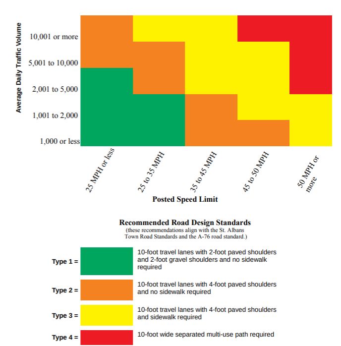
Page | 6St. Albans Bicycle and Pedestrian Master Plan Design and Location Guidelines There is a significant impact on pedestrian’s and bicyclist’s comfort and enjoyment when the speed differential between themselves and a passing motor vehicle is noticeable and traffic volumes are high. There are a range of facilities appropriate for a given roadway depending on vehicle speeds and daily traffic volumes. This plan provides a modular schematic for selecting the appropriate facility type. This plan's selection criteria is found on Figure 1. It provides practical information, decision making guidance, and illustrates the facility that may be considered under various traffic speeds and diverse traffic volume scenarios. The Modular Facility Schematic in Figure 1 guidelines do not account for existing bicycle or pedestrian traffic, which is only known at this time via hearsay evidence or subjective observations. Figure 1 - Modular Facility Design Schematic for Multi-Use Pathways and Sidewalks Please note: The Modular Facility Schematic is not a set of absolute decisions and is subject to changes and adaptions to appropriately fit any road’s existing configuration and surrounding development. Additionally, all sidewalks, multi-use pathways, and most walking trails must meet the requirements of the Americans with Disabilities Act Accessibility Guidelines. Page | 7
St. Albans Bicycle and Pedestrian Master Plan

    St. Albans adopted and revised regulations related to roads and driveways in 1988 and again
    2006. Lastly, in February 2013, St. Albans adopted of the Vermont State Design Standards, the
    A-76 Standards for Town and Development Roads under 19 V.S.A. Section 1111 and the B-71
    Standards for Residential and Commercial Drives. Please note that the A-76 design detail sheet
    states that the standards are for local low volume roads with an average daily traffic volume of
    250 or less and that higher volume roads require additional shoulder widths and paved shoulders

    PROPOSED FUTURE NETWORK
    Map 3 shows the proposed future bicycle and pedestrian network for the Town of St. Albans.
    The original Bicycle and Pedestrian Master Plan of 2018 proposed a network that primarily
    extended from the City of St. Albans network into the Town of St. Albans, filled the gaps in the
    existing sidewalk system, provided multi-use pathways for appropriate contexts and in certain
    locations. The 2021 updated plan is built under the assumption, that by building a backbone
    recreational path, the other projects make more sense and have more benefit for the average
    resident of the Town of St. Albans. The most important projects that were identified are listed in
    Table 2 with their corresponding priority as determined by the Planning Commission when
    updating this list based on feasibility and likely community support.

    Table 2: Priority Sidewalk and Multi-Use Pathway Projects

Priority                Route                            Location                       Facility Type and Notes
                                              Beginning at the Collins Perley
                                                                                Multi-use pathway. This one larger vision
                                              Sport Center and continuing
            Future St. Albans                                                   incorporates a number of priorities listed
1                                             North along VT-104, through
            Health Path                                                         in both 2003 and 2018. Broken down into
                                              the Hard’Ack property to the
                                                                                Phases in likely order of completion.
                                              Missisquoi Valley Rail Trail
                                    From the entrance of the Collins
            Phase 1: Collins Perley
1(a)                                Perley Sports Complex to
            Sports Center to SASH
                                    SASH.
                                                                                Multi-use pathway with an at-grade
            Phase 2: SASH                                                       crossing of the SASH - coordinate with
1(b)                                          Crossing of SASH
            Crossing                                                            2014 scoping study recommendations for
                                                                                volume of use by BFA students and others
            Phase 3: Continue path
1(c)        from SASH to           Along VT-104                                 Multi-use pathway.
            intersection of Rt 36.
            Phase 4: Rt 36 to
1(d)        Congress                          Running parallel to VT104         Multi-use pathway.
            Street/Hard’Ack.
                                              Working with the City of St.
            Phase 5: Congress
1(e)                                          Albans to find a logical path     Multi-use pathway.
            Street to Sheldon Rd
                                              through the hard’ack property.
            Phase 6: Sheldon Rd to
1(f)                               Can run parallel to I-89.                    Multi-use pathway.
            MVRT.

    Page | 8
St. Albans Bicycle and Pedestrian Master Plan
Priority Route Location Facility Type and Notes
New Town Hall to Bay Connecting the entrance of the
2 Park Sidewalk & Proposed New Town Hall to the Sidewalk and streetscape.
Streetscape. Bay Park.
Multi-use pathway, or sidewalk, to be
US Route 7 (South determined by a future scoping study,
3 from Georgia TL to Parson Ave.,
Main St) extending from City network to Georgia
Town line.
Sidewalk extensions from City network -
Both sides of road from City
4 Upper Welden Street provides connectivity for commercial and
limits to VT Route-104
residential areas between Town and City
Sidewalk extension from City network -
North side of the road from provides improved connectivity to the
5 Fairfield Street
Crest Road to Fisher Pond Road existing sidewalk on the south side of this
roadway
North side of the road from City Sidewalk extension from City network -
6 Congress Street limits to Hard’ack Recreation provides connectivity between recreation
Area area and residential neighborhoods
Sidewalk extension from City network
provides connectivity for neighborhoods
to the Collins Perley Sports Center - minor
Either side of road from City extension of city sidewalk required on
7 Fairfax Street line to Collins Perley Sports Fairfax Street to make connection to
Center existing City network on South Main
Street - exact placement to be determined
by future study - coordinate design with
bridge reconstruction at Rugg Brook
From City line to VT Route 105 Sidewalk connection for neighborhood to
High Street and
8 and continuation on north side rail trail - exact design and siting to be
VT Route 105
of VT Route 105 to rail trail determined by future engineering study
Sidewalk extension, paved shoulders, and
curbing from City line - provides
Both sides of road from
connectivity for commercial and
9 Lake Road Bronson Road to Adams
residential areas in Town and City - exact
Street/City line
configuration to be determined by future
engineering study
Both sides of the road from Sidewalk extensions from City network -
10 Nason Street Lapier Drive/Marc Ave to City provides safe connectivity for
line neighborhoods
Page | 9St. Albans Bicycle and Pedestrian Master Plan
Priority Route Location Facility Type and Notes
West side of the road from Sidewalk provides local connectivity
11 Lake Road (St. Albans Georgia Shore Road extending between residences, retail businesses, and
Bay)
to east for 1,275 ft. St. Albans Bay Park
Multi-use pathway extension from City
network - provides connectivity of retail
from Seymour Road/City Limits
12 US Route 7 (section 1) areas between Town and City and to rail
to former Energizer plant
trail - exact placement to be determined by
study
Multi-use pathway extension of priority #3
to I-89 exit 20 commercial sites - provides
from former Energizer plant to connectivity between commercial areas
13 US Route 7 (section 2) Wal-Mart; in fill connections on and rail trail - some sidewalk in-fill on
west side of road west side allows for local connectivity to
businesses - placement to be determined
by study
Page | 10St. Albans Bicycle and Pedestrian Master Plan Map 4 shows the very generalized outline of a proposed future trail network for the Town of St. Albans. Much more planning and design is needed to create and implement this network. Also, these trail systems do not include trails located within the Town Forest nor any other of our parks. The existing trail network is composed of “pirate” trails from existing neighborhoods to various locations around town. The “pirate” trails are primarily used by children and teens to provide shorter routes and faster connections to popular sites like the Collins Perley Sports and Fitness Center. Unfortunately, most of the “pirate” trails appear to use private property with some amount of tacit approval from the landowner, but without the appropriate legal easements to protect landowners from liability and from harmful trail construction methods. Page | 11
St. Albans Bicycle and Pedestrian Master Plan

Bicycle and Pedestrian Plan Costs
Table 3 below provides basic cost estimates for initial capital planning and major maintenance
analysis. Many of the projects are not defined sufficiently to determine a specific project cost
estimate. The project cost estimates below were developed by making general assumptions on
planning, design, engineering, and construction costs. All project costs were based on the
VTrans Report on Shared-Use Path and Sidewalk Unit Costs from January 2020.
Table 3 - Estimated Project Costs:
                                                  Low         High
                                                                         Cost per linear ft.
                Name                            Estimated   Estimated         (High)
                                                  Cost        Cost
Phase 1: Collins Perley Sports
                                                $145,550    $607,000           $342
Center to SASH
Phase 2: SASH Crossing                          $915,000    $935,000     Study Determined
Phase 3: Continue path from
SASH to intersection of Rt 36.
                                                $268,000    $1,115,000         $342
Phase 4: Rt 36 to Congress
Street/Hard’Ack.
                                                $164,000    $684,000           $342
Phase 5: Congress Street to
Sheldon Rd
                                                $471,500    $1,966,500         $342
Phase 6: Sheldon Rd to MVRT.                    $287,000    $1,197,000         $342
Potential New Town Hall to St.
Albans Bay Park
                                                $105,000    $310,000           $187
US Route 7 (South Main St)                      $400,000    $1,625,000         $187
Upper Welden Street                             $113,500     $326,450          $187
Fairfield Street                                 $73,000     $215,000          $187
Congress Street                                 $162,500     $475,000          $187
Fairfax Street                                  $730,000    $2,130,000         $187
High Street and VT Route 105                    $492,500     $890,000          $187
Lake Road                                       $360,000    $1,045,000         $187
Nason Street                                    $335,000     $970,000          $187
Lake Road (St. Albans Bay)                       $81,000     $237,500          $187
US Route 7 (section 1)                          $595,000    $1,736,000         $187
US Route 7 (section 2)                          $465,000    $1,860,000         $187

It should be noted that the larger projects and projects along State Highways will need to be
funded primarily through grants from VTrans or other sources that will require a small local
match. All projects, if funds are available, would be implemented over a period of about 25 years.

Page | 12
St. Albans Bicycle and Pedestrian Master Plan
Local Capital Planning
Local funding and project management is often the most cost-efficient way to complete small-
scale local projects. The Town of St. Albans should consider annual capital reserve funds that
will allow this plan to move forward. Annual capital reserve funds can also be used as a local
match for larger and more significant projects that are along State Highways. Annual capital
reserve funds can allow the Town of St. Albans to proceed with projects at a steady pace and
provide matching funds for federal and state grant programs.
State and Federal Grants
There are numerous grant opportunities to fund bicycle and pedestrian improvements, which
would help stretch local funds. However, many of these funding options have requirements or
constraints that make it important to be aware of the strengths and weaknesses of each funding
source. Since programs change and evolve over time, it is important to consult the funding
agency for more information on application processes, funding amounts, and other requirements.
Town Standards and Planning
Sidewalks, multi-use pathways, and trails facilitating recreation and the movement of people by
walking and bicycling are desirable elements in developing a better and more attractive
community. The Town of St. Albans will utilize this Bicycle and Pedestrian Master Plan to make
the improvements needed to improve and increase bicycle and pedestrian infrastructure
throughout town and to enhance safety.
The inclusion of sidewalks, multi-use pathways, and trails in new development projects will
continue to be the responsibility of developers. This master plan’s goal is to have new
development continue to incorporate bicycle and pedestrian amenities such that non-vehicular
users are accommodated where it is appropriate. Some small and localized elements to continue
are the following:
• Ensure that neighborhood facilities connect to existing or proposed roadside bikeways and
sidewalks.
• Ensure that neighborhood bicycle and pedestrian connect to adjoining neighborhoods and
other surrounding land uses.
• Improve accessibility for bicycles and pedestrians throughout all site plans.
The following are the recommended minimum design standards to be adopted as part of a
bicycle and pedestrian ordinance. Higher volume and intensive use areas are recommended to
have wider minimum cross sections.
• Sidewalks are recommended to be 5-foot wide made of Portland cement concrete.
• Multi-use paths are recommended to be 10-foot wide made of bituminous asphalt
pavement or compacted crushed stone with stone dust and designed for all season use.
• Trails are recommended to be 2.5-foot wide of compacted native soils, where appropriate,
and or compacted crushed stone with stone dust in high or intensive use sections.
Page | 13St. Albans Bicycle and Pedestrian Master Plan
IMPLEMENTATION
The following are suggested actions for St. Albans to consider as part of implementing this plan
and are based on information found within this plan. However, implementation of all bicycle and
pedestrian improvements and facilities are dependent on future funding opportunities.
• Apply for funding for a scoping study for the St. Albans Health Path during the 2021
Bicycle/Pedestrian Grant Program Cycle.
• Recommend that the Selectboard consider establishing an annual capital reserve account
for bicycle, pedestrian, and other associated infrastructure to fund improvements along
existing roads surrounding new development and throughout the north and south growth
centers.
• Recommend that the Selectboard begin funding and constructing the thirteen-priority
sidewalk and multi-use pathway projects listed in Table 2 using a combination of local
funds, and state/federal grants.
• Trail construction in the north or south growth centers is not recommended, due to the
potential high user volumes and intensity of use. In either growth center multi-use
pathways surfaced with bituminous asphalt pavement and sidewalks surfaced with
Portland cement concrete are recommended to handle the likely very high number of
users, to facilitate snowplowing, and to permit year-round use.
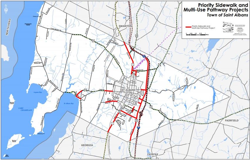
Page | 14St. Albans Bicycle and Pedestrian Master Plan DRAFT - May 26, 2021 Map 3: Priority Bicycle and Pedestrian Infrastructure Page | 15
St. Albans Bicycle and Pedestrian Master Plan

Map 4: Long Range Trail Planning

Page | 16
St. Albans Bicycle and Pedestrian Master Plan

Page | 17
St. Albans Bicycle and Pedestrian Master Plan                                            DRAFT - May 26, 2021

Table 4 - Recommended Bicycle and Pedestrian Improvements by Road Segment

                                                Road Type
                                                 Number
                                                  from
                                                 Modular
                                                 Facility         Suggested Bicycle and Pedestrian
                                                 Design         Improvements recommended based on
Road Name                                       Schematic           Current Road Configuration
Adams Street                                        1       No improvements recommended at this time
Adirondack Drive                                    1       No improvements recommended at this time
Aldis Street                                        1       No improvements recommended at this time
Ashton Drive                                        1       No improvements recommended at this time
Austin Road                                         1       No improvements recommended at this time
Bayview Drive                                       1       No improvements recommended at this time
Beauregard Drive                                    1       No improvements recommended at this time
                                                            Special Design recommended due to truck traffic
Benoit Drive (Formerly Industrial Park                      -10-foot travel lanes with 2-foot paved shoulders,
Drive)                                              2       2-foot gravel shoulders, and a sidewalk
Bluff Lane                                          1       No improvements recommended at this time
Bradley Court                                       1       No improvements recommended at this time
Brigham Road                                        1       No improvements recommended at this time
Bronson Road                                        2       10-foot travel lanes with 4-foot paved shoulders
Bushey Drive                                        1       No improvements recommended at this time
Button Road                                         1       No improvements recommended at this time
Cedar Hill Drive                                    1       No improvements recommended at this time
Cherry Street                                       1       No improvements recommended at this time
Chubb Street                                        1       No improvements recommended at this time
Church Road                                         1       No improvements recommended at this time
Clyde Allen Drive                                   1       No improvements recommended at this time
                                                            Special Design recommended to fit existing
                                                            development - Sidewalk extension from City line
                                                            along north side of road with 10-foot travel lanes
Congress Street                                     1       and 2-foot paved shoulders
County Road                                         1       No improvements recommended at this time
Dunsmore Road                                       1       No improvements recommended at this time
Eastview Drive                                      1       No improvements recommended at this time

Page | 18
St. Albans Bicycle and Pedestrian Master Plan DRAFT - May 26, 2021
Road Type
Number
from
Modular
Facility Suggested Bicycle and Pedestrian
Design Improvements recommended based on
Road Name Schematic Current Road Configuration
Elizabeth Street 1 No improvements recommended at this time
Special Design recommended due to truck traffic
Emergency Road (Formerly part of -10-foot travel lanes with 2-foot paved shoulders,
Industrial Park Road) 2 2-foot gravel shoulders, and a sidewalk
Special Design recommended to fit existing
development - 10-foot travel lanes with 2-foot
Fairfax Street 3 paved shoulders and sidewalk along one side
Forest Drive (Class 4 road) 1 No improvements recommended at this time
10-foot travel lanes with 2-foot paved shoulders
and 2-foot gravel shoulders with circumferential
Franklin Park West multi-use pathway as required via an Act 250
- Parah Drive to end 1 decision in 2005
Special Design recommended to fit existing
development and traffic volume - 10-foot travel
Franklin Park West (80') lanes with 2-foot paved shoulders and sidewalk
- US Route 7 to Parah Drive 3 along each side
Fred Lake Road 1 No improvements recommended at this time
Freeborn Street 1 No improvements recommended at this time
French Hill Road 1 No improvements recommended at this time
Special Design recommended to fit existing
Georgia Shore Road
(Lake Champlain Bikeway) development - 10-foot travel lanes with 2-foot
- Lake Road to Patten Crosby Road 2 paved shoulders and sidewalk along southern side
Georgia Shore Road
(Lake Champlain Bikeway) 10-foot travel lanes with 4-foot paved shoulders
- Patten Crosby Road to Georgia TL 2 and no sidewalk
Georgie Avenue 1 No improvements recommended at this time
Giroux Road 1 No improvements recommended at this time
Green Mountain Drive 1 No improvements recommended at this time
Harbor View Drive 1 No improvements recommended at this time
Special Design recommended to fit existing
development - 10-foot travel lanes with 2-foot
Hathaway Point Road 2 paved shoulders
Page | 19St. Albans Bicycle and Pedestrian Master Plan DRAFT - May 26, 2021
Road Type
Number
from
Modular
Facility Suggested Bicycle and Pedestrian
Design Improvements recommended based on
Road Name Schematic Current Road Configuration
Special Design recommended to fit existing
development - 10-foot travel lanes with 2-foot
High Street 1 paved shoulders and sidewalk along one side
Hillfarm Estates 1 No improvements recommended at this time
Huntington Street 1 No improvements recommended at this time
Special Design recommended due to truck traffic
-10-foot travel lanes with 2-foot paved shoulders,
Industrial Park Road 2 2-foot gravel shoulders, and a sidewalk
James Circle 1 No improvements recommended at this time
Jewell Street 1 No improvements recommended at this time
10-foot travel lanes with 4-foot paved shoulders
Jewett Avenue 2 and no sidewalk
10-foot travel lanes with 4-foot paved shoulders
Kellogg Road 2 and no sidewalk
Lakemont Drive 1 No improvements recommended at this time
Lapan Road 1 No improvements recommended at this time
Laurie Avenue 1 No improvements recommended at this time
Lebel Drive 1 No improvements recommended at this time
Little County Road 1 No improvements recommended at this time
Lord Road 1 No improvements recommended at this time
Maquam Shore Road 10-foot travel lanes with 4-foot paved shoulders
(Lake Champlain Bikeway) 2 and no sidewalk
Marc Avenue 1 No improvements recommended at this time
Marcel Drive 1 No improvements recommended at this time
McGinn Drive 1 No improvements recommended at this time
Meadowbrook Lane 1 No improvements recommended at this time
Mechanic Street 1 No improvements recommended at this time
Michelle Drive 1 No improvements recommended at this time
Montagne Road 1 No improvements recommended at this time
Page | 20St. Albans Bicycle and Pedestrian Master Plan DRAFT - May 26, 2021
Road Type
Number
from
Modular
Facility Suggested Bicycle and Pedestrian
Design Improvements recommended based on
Road Name Schematic Current Road Configuration
Special Design recommended to fit existing
Nason Street development - 10-foot travel lanes with 2-foot
- CL to Marc Avenue 1 paved shoulders and sidewalk along one side
Nason Street
- Marc Avenue to Bronson Road 1 No improvements recommended at this time
Old Orchard Road 1 No improvements recommended at this time
Orchard Street 1 No improvements recommended at this time
Paquette Road 1 No improvements recommended at this time
Special Design recommended to fit existing
development – 10-foot travel lanes with 2-foot
Parah Drive paved shoulders and sidewalk along one side to
- short segment to connect with circumferential
multi-use pathway as required via an Act 250 connect with planned circumferential multi-use
decision in 2005 1 pathway for Franklin Park West
Parah Drive
- all other remaining segments of road 1 No improvements recommended at this time
Parsons Avenue 1 No improvements recommended at this time
Parsons Lane 1 No improvements recommended at this time
Patten Crosby Road 1 No improvements recommended at this time
Pearl Avenue 1 No improvements recommended at this time
Pearl Avenue Extension 1 No improvements recommended at this time
Pearl Street 1 No improvements recommended at this time
Perry Road 1 No improvements recommended at this time
Pike Drive 1 No improvements recommended at this time
Pion Road 1 No improvements recommended at this time
Potter Avenue 1 No improvements recommended at this time
Prospect Hill Road 1 No improvements recommended at this time
Quarry Court 1 No improvements recommended at this time
Rugg Road 1 No improvements recommended at this time
Samantha Lane 1 No improvements recommended at this time
Samson Road 1 No improvements recommended at this time
Page | 21St. Albans Bicycle and Pedestrian Master Plan DRAFT - May 26, 2021
Road Type
Number
from
Modular
Facility Suggested Bicycle and Pedestrian
Design Improvements recommended based on
Road Name Schematic Current Road Configuration
Seminary Hill Road 1 No improvements recommended at this time
Special Design recommended to fit existing
development - 10-foot travel lanes with 2-foot
Seymour Road 1 paved shoulders and sidewalk along one side
Summit Place 1 No improvements recommended at this time
Sunset Terrace 1 No improvements recommended at this time
Thorpe Avenue Extension 1 No improvements recommended at this time
Twin Court 1 No improvements recommended at this time
Special Design recommended to fit existing
development - 10-foot travel lanes with 2-foot
Upper Welden Street 2 paved shoulders and sidewalk along one side
US Route 7 (Swanton Road) 4 10-foot wide separated multi-use path required
US Route 7 (North Main Street) 4 10-foot wide separated multi-use path required
US Route 7 (South Main Street) 10-foot travel lanes with 4-foot paved shoulders
- CL to Prospect Hill Road 3 with sidewalk
US Route 7 (South Main Street) 10-foot travel lanes with 4-foot paved shoulders
- Prospect Hill Road to Georgia TL 2 and no sidewalk
Vivian Lane 1 No improvements recommended at this time
10-foot travel lanes with 4-foot paved shoulders
VT Route 36 (Fairfield Hill Road) 3 with no sidewalk
Special Design recommended to fit existing
development - 10-foot travel lanes with 2-foot
VT Route 36 (Fairfield Street) 2 paved shoulders and sidewalk along one side
Special Design recommended to fit existing
VT Route 36 (Lake Road) development - 10-foot travel lanes with 2-foot
- CL to Bronson Road 2 paved shoulders and sidewalks along both sides
VT Route 36 (Lake Road) 10-foot travel lanes with 4-foot paved shoulders
- Bronson Road to Little County Road 2 and no sidewalk
Special Design recommended to fit existing
VT Route 36 (Lake Road) development - 10-foot travel lanes with 2-foot
- Little County Road to Georgia Shore Road 2 paved shoulders and sidewalk along one side
Page | 22St. Albans Bicycle and Pedestrian Master Plan DRAFT - May 26, 2021
Road Type
Number
from
Modular
Facility Suggested Bicycle and Pedestrian
Design Improvements recommended based on
Road Name Schematic Current Road Configuration
VT Route 36 (Lake Road) 10-foot travel lanes with 4-foot paved shoulders
- Georgia Shore Road to Maquam Shore Road 2 and no sidewalk
VT Route 38 (Lower Newton Road) 10-foot travel lanes with 4-foot paved shoulders
- CL to Kellogg Road 2 and no sidewalk
VT Route 38 (Lower Newton Road) 10-foot travel lanes with 4-foot paved shoulders
- Kellogg Road to Dunsmore Road 2 and no sidewalk
VT Route 38 (Lower Newton Road) 10-foot travel lanes with 4-foot paved shoulders
- Dunsmore Road to Maquam Shore Road 2 and no sidewalk
Special Design recommended for rural area - 10-
VT Route 104 (Fisher Pond Road) foot travel lanes with 4-foot paved shoulders with
- VT Route 105 to Congress Street 3 no sidewalk
VT Route 104 (Fisher Pond Road)
- Congress Street to Fairfax Street 4 10-foot wide separated multi-use path required
10-foot travel lanes with 4-foot paved shoulders
VT Route 104 (Fairfax Road) with sidewalk from Allaire Drive to Fairfax Street
- Fairfax Street to Fairfield TL 3 – no sidewalk south of Allaire Drive
VT Route 105 (Sheldon Road) 10-foot travel lanes with 4-foot paved shoulders
- Swanton TL to High Street 2 and no sidewalk
Special Design recommended to fit existing
VT Route 105 (Sheldon Road) development - 10-foot travel lanes with 2-foot
- High Street to US Route 7 2 paved shoulders and sidewalk along one side
Ward Terrace 1 No improvements recommended at this time
Westview Drive 1 No improvements recommended at this time
Wharf Street 1 No improvements recommended at this time
Wiley Place 1 No improvements recommended at this time
Page | 23You can also read