Black Country Urban Capacity Review December 2019 - Sensitivity: NOT PROTECTIVELY MARKED
←
→
Page content transcription
If your browser does not render page correctly, please read the page content below
Sensitivity: NOT PROTECTIVELY MARKED

                            Black Country
                           Urban Capacity
                                   Review
                           December 2019

                                            1|Page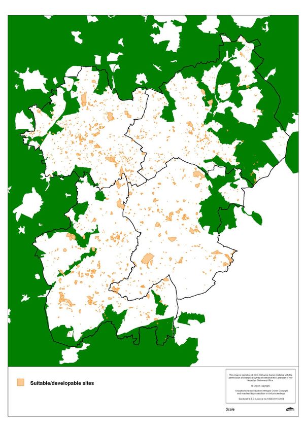
Sensitivity: NOT PROTECTIVELY MARKED

        Black Country Urban Capacity Review - December 2019

        Contents
          1     Introduction                                      3

          2     Summary of Current Evidence                       7

                2.1      Meeting Housing Need                     7
                2.2      Meeting Employment Land Need             18
          3     Identification of Potential Additional Capacity   21

                3.1      Potential Changes to Housing Supply      21
                3.2      Potential Changes to Employment Land
                         Supply                                   32
           4   Conclusions                                        34

        Appendix 1       List of Evidence to be progressed
                         during 2019 / 2020                       36

        Appendix 2       Black Country Housing Trajectory
                         2006-38                                  37

                                                                  2|Page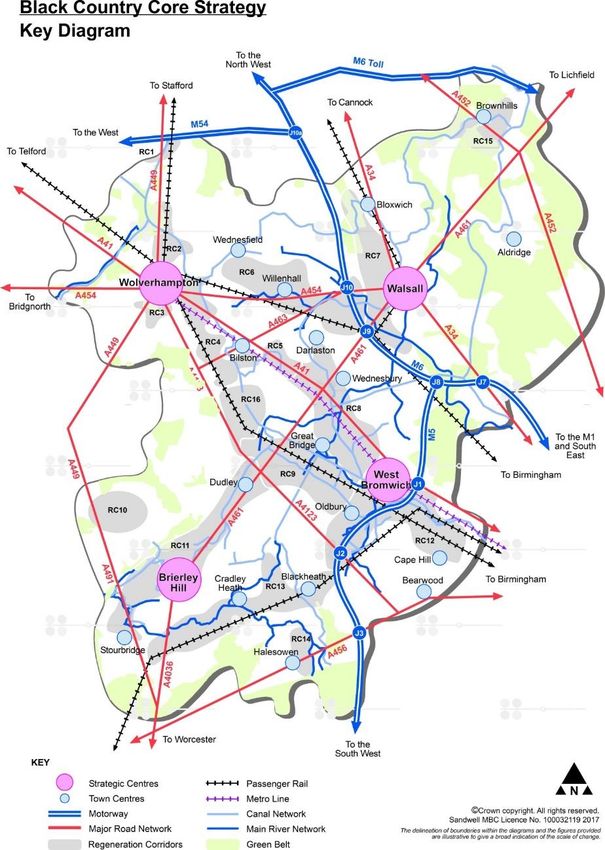
Sensitivity: NOT PROTECTIVELY MARKED

        1.         Introduction
        1.1        The current Black Country Core Strategy (2011), and associated development plan
                   documents, identify where the majority of the development needs of the Black
                   Country1 will be accommodated up to 2026. A key priority for the current Core
                   Strategy was to focus development into a series of strategic growth corridors and
                   centres and to promote a brownfield first strategy, since all identified needs could,
                   at that time, be accommodated within the urban area. The urban area is that part
                   of the Black Country which does not fall within the Green Belt as shown on Map 1.
        1.2        A review of the Core Strategy (now to be called the Black Country Plan) is now
                   underway. The review will consider the up-to-date housing and employment needs
                   of the area over a longer period, to ensure that the new Plan provides for the
                   needs of the area for at least 15 years from the anticipated adoption year.
        1.3        As part of this review, the Issues and Options consultation (2017) set out the
                   updated need figures for housing and employment across the Black Country up to
                   2036. The Issues and Options consultation highlighted that accommodating
                   identified development needs up to 2036 would be challenging and, in order to
                   plan for growth over this longer period, it would be necessary to consider a review
                   of Green elt boundaries across the Black Country. In addition, the West Midlands
                   Combined Authority has published ambitious growth targets for the wider region
                   in its Strategic Economic Plan.
        1.4        This report sets out the current position, using best available evidence and
                   information, regarding the need for and supply of land for housing and
                   employment in the Black Country over an extended Plan period - up to 2038, 15
                   years from the current anticipated adoption year of 2023. It is being prepared to
                   inform preparation of the Black Country Plan and to meet planning policy
                   requirements set out in paras 136 and 137 of the NPPF regarding the exceptional
                   circumstances for release of land from the Green Belt for development.
        1.5       Para 136 of the NPPF states that: “Once established, Green Belt boundaries should
                  only be altered where exceptional circumstances are fully evidenced and justified,
                  through the preparation or updating of plans.” Para 137 goes on to explain that:
                  “Before concluding that exceptional circumstances exist to justify changes to Green
                  Belt boundaries, the strategic policy-making authority should be able to
                  demonstrate that it has examined fully all other reasonable options for meeting its
                  identified need for development.”, in particular: “whether the strategy: (a) makes
                  as much use as possible of suitable brownfield sites and underutilised land; (b)
                  optimises the density of development … including whether policies promote a
                  significant uplift in minimum density standards in town and city centres and other
                  locations well served by public transport.”
        1.6        This report reviews current assumptions about the supply of land for housing and
                   employment development across the Black Country. It uses current available
                   evidence to seek to maximise delivery in the urban area by reviewing previous
                   assumptions – for example in relation to densities - with a view to optimising
                   opportunities to identify any further additional potential development capacity
                   across the urban area. Ultimately it provides ‘potential urban capacity’ figures

        1
            The Black Country comprises: Dudley, Sandwell, Walsall and Wolverhampton
                                                                                             3|Page
Sensitivity: NOT PROTECTIVELY MARKED
which demonstrate how far the development needs of the Black Country up to
2038 can be accommodated within the urban area.
Map 1 Black Country Core Strategy Key Diagram
4|PageSensitivity: NOT PROTECTIVELY MARKED
1.7 It will be necessary to continue to review and update information and assumptions
in the Urban Capacity Review report as the Plan preparation progresses. Further
work will take place to continue to develop evidence to support the Plan
preparation process, as set out in Appendix 1. Further updates to the UCR will
therefore be made when new evidence is available and also when housing and
employment monitoring information is updated on an annual basis. The next
update to the UCR will take place in 2020, to accompany the Draft Plan due to be
published for consultation in autumn 2020.
Duty to Co-operate
1.8 The Black Country Authorities will continue to work with neighbouring Local
Authorities via established Duty to Co-operate meetings on this and other key
strategic planning issues, to discuss and agree how development needs across the
wider area could be accommodated.
1.9 A key example of this co-operation is a suite of ongoing partnership work which
has taken place to address the housing needs of the Greater Birmingham and Black
Country Housing Market Area2 (GBBCHMA). This commenced with the joint
commissioning of a GBBCHMA Strategic Housing Needs Study (2014/2015), which
reviewed and identified the emerging housing need and supply across the
GBBCHMA. This Study identified a shortfall of at least 37,600 homes across the
HMA up to 2031, the majority arising in Birmingham as reflected in the adopted
Birmingham Development Plan (2017), which has an end date of 2031. The
GBBCHMA Strategic Growth Study (2018) updated need and supply figures and
estimated a shortfall of 28,150 homes up to 2031, plus an additional shortfall of
32,700 homes over the period 2031-36, across the HMA. This Study also identified
potential strategic locations where growth could be accommodated to help meet
this shortfall – considering Green Belt, landscape and other technical planning
issues at a strategic scale.
1.10 These Studies have been supplemented by a GBBCHMA Housing Need and Housing
Land Supply Position Statement (Sept 2018), which sets out the position on
housing need and supply up to 2031 relating to the HMA, as of April 2017. This
Statement concluded that, following formal commitments from some neighbouring
authorities towards the unmet need and a significant increase in housing capacity
identified in Birmingham, the shortfall across the HMA up to 2031 had been
reduced to 10,696 homes. The Black Country figures used in the Position
Statement are taken from 2017 SHLAAs and are now out of date. The 2019 Urban
Capacity Review Report (and subsequent updates) will feed into future updates to
the Position Statement and other documents produced by the HMA authorities.
1.11 The Black Country Authorities will also continue to engage with neighbouring local
authorities over employment land provision. A key element of the existing Black
Country Core Strategy is reliant upon the provision of strategic employment sites
2
The GBBCHMA comprises: Birmingham, the Black Country authorities, Bromsgrove, Cannock Chase, Lichfield,
part of North Warwickshire, Redditch, Solihull, South Staffordshire, part of Stratford-upon-Avon and Tamworth
5|PageSensitivity: NOT PROTECTIVELY MARKED
in South Staffordshire District to contribute towards meeting needs arising in the
Black Country and which cannot be met within the administrative area.
6|PageSensitivity: NOT PROTECTIVELY MARKED
2. Summary of Current Evidence
2.1 Housing Need and Supply
2.1.1 This section of the report provides current information on housing need and
housing land supply in the Black Country authorities. This is an update of the
information provided in the Housing Background Report produced to support the
Black Country Core Strategy review - Issues and Options Report. It demonstrates
the efforts that are being undertaken to maximise the potential supply that might
be provided from previously developed and other brownfield land within the
existing urban area. It provides an updated estimate of the scale of this important
element of the supply.
2.1.2 The description of the supply is broken down into two parts. This first part
describes the current identified supply, the majority of which covers the existing
BCCS period up to 2026. It details current sources of evidence and explains the
assumptions and allowances that have been made when calculating this supply.
The second part (in section 3) describes potential additional sources of supply up
to 2038 which will be tested as part of the evidence which will feed into the Draft
Plan for consultation. Current housing evidence, including the Strategic Housing
Land Availability Assessments (SHLAA) and the Strategic Housing Market
Assessment (SHMA), can be viewed in full on the Black Country Plan website at
https://blackcountryplan.dudley.gov.uk/t2/ . All of the Black Country SHLAAs were
updated in 2019 and inform this report.
Housing Need
2.1.3 The existing BCCS housing targets for each Black Country authority for the period
up to 2026 are set out in Table 7 of the BCCS. When the BCCS was adopted, the
established process was to take into account historic completion rates when
calculating future targets. Although the SHLAAs do compare housing supply
against BCCS targets, new Government guidance issued in 2017/18 states that if
a Plan is more than 5 years old (which applies to the BCCS), the new national
standard methodology should be used for calculating 5 year housing land supply
and for developing new Plans.
2.1.4 Government guidance requires Local Authorities to determine the local housing
need figure for their area. The Plan preparation process should then test the
deliverability of this housing need figure within the Local Authority area. The local
housing need figure for the Black Country is calculated by summing the national
standard method figure for each individual authority. This method uses 2014-
based ONS household projections and affordability ratios which are updated
annually. The housing need figure is currently 3,761 homes per annum
which equates to 71,459 homes over the period 2019-38. It should be
noted that, when the Draft Black Country Plan reaches publication stage (reg 19)
in 2021, the per annum figure used will be slightly different and the period used
will be 2020-38, as the new method applies only to future years. A key aim of the
7|PageSensitivity: NOT PROTECTIVELY MARKED
Black Country Plan is to plan to meet all of this housing need within the Black
Country and, if this need cannot all be accommodated within the Black County, to
work with other Authorities to see if they can accommodate any of the unmet Black
Country need.
Housing Supply
2.1.5 The current identified housing supply in the Black Country is described in the
Strategic Housing Land Availability Assessments (SHLAAs) produced by each of the
four local authorities. The purpose of a SHLAA is to identify all sites in a Local
Authority area which are suitable for housing and which are deliverable over the
next 5 years3 or developable4 over the Plan period. Each SHLAA includes a
trajectory to show how delivery is expected to be phased annually up to the end
of the current BCCS period (2026) and beyond, to meet the needs of the new Plan
up to 2038.
2.1.6 The identification and assessment of potential housing sites for inclusion in the
current SHLAAs has followed Government guidance, best practice, sustainability
principles and the spatial strategy of the current BCCS. This means that sites follow
a “brownfield first” principle, and mainly comprise sites with planning permission,
allocations on surplus occupied employment land and other sites in the growth
network. The list of sites is updated annually in order to continue to identify
development sites in the urban areas and to focus development into the right
places.
2.1.7 The current SHLAAs include, as far as possible, every identifiable site within the
urban area which is both suitable for housing and realistically deliverable or
developable, including brownfield and greenfield sites. This includes sites under
construction, sites with planning permission and sites allocated in adopted Local
Plans. It also includes any other sites which are currently considered to have
housing capacity, including both vacant and occupied sites. Only where a site has
a realistically implementable permission for an alternative, non-housing use will it
be removed from the list of SHLAA sites. An on-going “call for sites” in each
authority ensures that this list of sites is accurate and up-to-date, reflecting market
intelligence and land-owners’ intentions. This has been supplemented by the Black
Country “call for sites” exercise carried out during 2017-19 to inform the BCP
review.
2.1.8 The SHLAA reports for the four authorities and a map showing the current SHLAA
sites for the Black Country authorities – both suitable and unsuitable – can be
viewed on the Black Country Plan web site at
https://blackcountryplan.dudley.gov.uk/t2/p3/. Map 2 illustrates the distribution
3
The NPPF states that sites considered deliverable “… should be available now, offer a suitable location for
development now, and be achievable with a realistic prospect that housing will be delivered on the site within
five years.”
4
The NPPF defines developable sites as those “in a suitable location for housing development with a
reasonable prospect that they will be available and could be viably developed at the point envisaged”
8|PageSensitivity: NOT PROTECTIVELY MARKED
of suitable SHLAA sites across the Black Country. The brownfield SHLAA sites also
form the basis of each authority’s Brownfield Land Register (Part 1).
Map 2 Strategic Housing Land Availability Assessment (SHLAA) sites suita-
ble for housing within the Black Country (Green Belt shown in green)
9|PageSensitivity: NOT PROTECTIVELY MARKED
2.1.9 The assessment of housing land supply in the SHLAAs also includes an allowance
for “windfalls”. This is to account for currently unidentified sites that may come
forward over the Plan period. The main element of the windfall allowance is small
sites of 9 homes or less, which are usually too small to allocate in the Black Country.
These windfall allowances are included as past trends demonstrate that windfalls
comprise a significant element of the Black Country housing supply. Further
information is provided below.
2.1.10 A number of assumptions and allowances underlie the current housing supply set
out in the BCCS and current SHLAAs. These are set out below.
Discount Rates
2.1.11 Discounts were applied to some sources of housing supply in the BCCS to allow for
potential non-implementation during the plan period. A discount rate of 10% was
applied to sites which were commitments in 2009 (including permissions and
allocations) and a discount rate of 15% was applied to unidentified sites that were
expected to come forward within the regeneration corridors or freestanding
employment sites, given these sites had not yet been identified and were expected
to be subject to multiple constraints on delivery.
2.1.12 These discount rates were examined independently by the BCCS Inspector and
accepted as reasonable. As set out in the footnote to Table 1 below, all SHLAAs
now reflect this level of discount - the capacity of sites not yet under construction
has been discounted by 10%, and the capacity of allocated sites on surplus
occupied employment land has been discounted by 15%.
Demolitions
2.1.13 The BCCS assumed that nearly 6,900 homes would be demolished up to 2026 as
part of housing renewal schemes across the Black Country, with half of these
predicted to take place during 2016-26. The replacement rate assumed for these
sites was 52% overall, therefore it was assumed that housing renewal would
remove 3,340 homes from the housing supply by 2026.
2.1.14 Only a small number of anticipated schemes, totalling 1,374 demolitions, have
taken place since 2009 and large-scale housing renewal programmes have largely
now come to an end. In addition, replacement rates on schemes which have taken
place have typically been higher than expected. The current position on projected
demolitions and replacement rates is reflected in individual SHLAA reports.
Density
2.1.16 BCCS Policy HOU2 and the associated Table 8 expect all sites of 15 homes or more
to achieve a density of 35 dwellings per hectare (dph), net of open space and
major roads. 35 dph generally relates to a development with a mix of house sizes
and no flats. The Policy also requires developments of 60 dph or more (which
10 | P a g eSensitivity: NOT PROTECTIVELY MARKED
generally have a majority of flats) to be located within strategic or town centres,
and for other high density developments (45-60 dph) to have good access to
residential services by foot or public transport.
2.1.17 For Site Allocations Documents (SAD), Area Action Plan (AAP) allocations, and sites
in SHLAAs that do not yet have planning permission, this density guidance is used
to calculate the potential number of dwellings that could be accommodated on
each site, unless there are additional particular local factors that also need to be
considered.
2.1.18 In particular, where there is no detailed information available, surplus occupied
employment sites have an assumed density of 35 dph gross, which is the
equivalent of 41 dph net assuming an 85% net developable area. This was found
to be the average on such sites taking into account open space, buffers, main
roads and other constraints. An assumed density of 50 dph gross has been used
for highly accessible locations, in line with assumptions made in the BCCS.
Windfall Allowances
2.1.19 The complex nature of the Black Country means that it will never be possible to
identify through the Local Plan process every potential housing site that may come
forward in the future. Supply from unidentified sites which may come forward in
future is generally referred to as a windfall allowance. Government guidance
accepts this approach.
2.1.20 The current BCCS included a windfall allowance for small sites of less than 15
homes. This allowance was supported by the Core Strategy Inspector’s Report,
which states at para 54: “In a largely built up area, such as the Black County, we
accept that such an allowance is appropriate and locally justified in relation to
guidance…”. This allowance accounted for just under 6% of total housing land
supply in the BCCS, or 418 homes per year across the Black Country.
2.1.21 At this time (2011) national policy did not allow for windfalls to be taken into
account in the 5 year supply, which reduced the average rate per annum. Para 70
of the NPPF now allows LPAs to make an allowance for windfall sites as part of
anticipated supply where there is “… compelling evidence that they will provide a
reliable source of supply. Any allowance should be realistic having regard to the
strategic housing land availability assessment, historic windfall delivery rates and
expected future trends.”
2.1.22 In general, site allocations across the Black Country are now ten homes or more,
and the national definition of major developments is ten homes / 0.5 ha or more.
It is also important, in the context of the Black Country Plan review, to standardise
approaches to housing supply across the sub-region. Therefore, it was agreed
from 2015/16 onwards to apply a common definition for small windfall sites across
the Black Country of nine homes / 0.25 ha or less. Such sites are not normally
large enough to be allocated as development sites in local plans – but they are
11 | P a g eSensitivity: NOT PROTECTIVELY MARKED
accounted for in SHLAAS, making up around 640 homes per annum of supply from
the mid-2020’s onwards.
Surplus Occupied Employment Land
2.1.23 The BCCS expected that a large proportion of the land for housing required over
the Plan period would be provided through the redevelopment of surplus occupied
employment land – land which was not anticipated to be suitable or needed for
employment uses but which could be suitable and developable for housing. This
approach was based on both employment land evidence, which indicated that
there would be a large surplus of low quality employment land over the Plan period,
and historic trends, which evidenced the widespread closure and release of factory
sites for housing across the industrial core of the Black Country since the industrial
decline of the 1970s.
2.1.24 BCCS Table 7 sets out the requirement for around 25,000 homes to be brought
forward on surplus occupied employment land by 2026 - around half of this to be
located in Sandwell. BCCS Appendix 2 set out broad locations (Regeneration
Corridors and free-standing employment sites) where housing allocations on
occupied employment land were expected to be made through preparation of Site
Allocation Documents (SADs) and Area Action Plans (AAPs). Given the multiple
constraints likely to affect such sites, a discount rate of 15% was applied to the
supply from such allocations, meaning that around 29,400 homes would need to
be allocated to deliver 25,000 homes in practice.
2.1.25 Following adoption of the BCCS, detailed evidence was prepared to support SADs
and AAPs across the Black Country, sufficient to identify specific housing allocations
in the identified broad locations. Progress made on achieving the 29,400 home
target is set out below:
The Dudley Development Strategy allocates 116 ha of land on 36 occupied
employment sites for 3365 homes. Of these, 20 homes (on 0.5 ha) are now
complete and 193 homes (on 4.5 ha) have planning permission as of 2019.
The Walsall SAD does not allocate any occupied employment land for housing
up to 2026. However, it does make reference to 75 ha of land on occupied
employment sites which are classified as “consider for release” with potential
to come forward for housing by 2026. These potential sites are not included
in housing land supply calculations as there is no certainty that they are
developable.
The Sandwell SAD and West Bromwich AAP allocate 311 ha of land on 127
occupied employment sites to be redeveloped for 10,541 homes by 2026.
However, 12 of these sites, totalling 51 ha and providing 1471 homes, were
subsequently removed from the housing land supply because there had been
investment by the existing occupiers indicating their intention to remain on the
sites concerned and they were therefore judged to be not
developable/deliverable. Of the remainder, 578 homes (14 ha on 7 sites) are
12 | P a g eSensitivity: NOT PROTECTIVELY MARKED
now complete and 510 homes (23 ha on 10 sites) have planning permission as
of 2019.
Wolverhampton Area Action Plans and Heathfield Park Neighbourhood Plan
allocate 39.5 ha of land on 17 occupied employment sites for 1297 homes by
2026. Of these, 81 homes (on 1.5 ha) have planning permission and are under
construction as of 2019.
2.1.26 In summary, Black Country housing allocations on occupied employment land
originally totalled 15,203 homes on 467 ha of land – which was significantly below
the BCCS target of 29,400 homes. This is because the detailed evidence available
when preparing SADs and AAPs did not support the allocation of sufficient suitable
sites for housing.
2.1.27 Since these sites were allocated through the adoption of Local Plans during 2013-
17, only 598 homes have been completed and an additional 684 homes have
secured planning permission. 51 ha (1471 homes) of sites in Sandwell have also
subsequently been removed from the housing land supply because there had been
investment in the sites concerned and they were therefore judged to be not
developable/deliverable. This clearly demonstrates the multiple constraints which
typically affect such sites. These constraints include: business relocation logistics
and costs; fragmented land ownership and high land assembly costs; high land
remediation costs due to former mining and contamination; and low market values.
Such constraints are widespread across the remaining 372 ha of allocation sites.
2.1.28 In response to these delivery and viability challenges, a range of policy tools and
funding mechanisms are being deployed, primarily through the Black Country Local
Enterprise Partnership (BCLEP) and West Midlands Combined Authority. These
include the £150m Black Country Land and Property Investment Fund (LPIF) and
the West Midlands Housing Deal Land Fund of £100m focussed on the Walsall to
Wolverhampton Corridor. These funding mechanisms are time limited and on their
own are not capable of addressing the viability gap associated with the delivery of
the totality of the sites outlined in para 2.1.27 above, as recognised by the WMCA
Land Commission in their 2017 Final Report. The Black Country Authorities will
therefore continue to engage with Government, WMCA, the BCLEP and other public
sector delivery agencies to secure additional support to assist with the delivery of
key development opportunities.
2.1.29 Preparation of SADs, AAPs and SHLAAs, as well as monitoring and analysis of actual
housing delivery achieved since 2011, has prompted a review of BCCS assumptions
on the release of surplus employment land for housing through the Black Country
Plan review.
2.1.30 Evidence presented in the Issues and Options Report to support the Black Country
Plan review highlights that, in recent years, rather than a surplus of employment
land across the Black Country, there is now a need for a net increase in
employment land over the new Plan period. This could require the retention of
more of the existing employment land that might have been expected previously
to be released for housing. The Black Country Economic Development Needs
13 | P a g eSensitivity: NOT PROTECTIVELY MARKED
Assessment (EDNA) Stage 1, summarised in section 2.2, provides detailed
information on the need for and supply of employment land.
2.1.31 During 2019, further detailed evidence has been progressed to support the Black
Country Plan review in the form of the Black Country EDNA Stage 2 and the Black
Country Employment Area Review (BEAR). The BEAR and EDNA2 will be published
alongside the draft Plan in 2020 but the fieldwork and analysis is largely complete.
This work is providing a comprehensive review of the quality and long term
sustainability of the Black Country’s employment areas for continued employment
use and the extent to which occupied employment sites currently allocated for
housing should continue to be allocated for redevelopment.
2.1.32 The BEAR is based on detailed fieldwork and engagement with occupiers and
landowners to establish their current intentions for employment sites and future
business needs. This work provides key evidence to inform what position the Black
Country Plan should adopt on the protection and retention of existing employment
areas up to 2038 and which of the existing housing allocations involving the
redevelopment of employment land should be deleted, with those sites retained
for employment activity.
2.1.33 The BEAR work has shown that many of the occupied employment sites currently
allocated for housing are home to businesses which have either invested in their
premises and/or intend to remain in situ in the long term, and specifically
throughout the new Plan period. This, coupled with the strategic need to plan
for a net increase in employment land, strongly suggests that these sites should
be retained for employment uses and current housing allocations deleted through
the Black Country Plan review. The impact of the BEAR work to date on housing
land supply is summarised in Table 1.
Table 1 – Impact of Employment Land Evidence (EDNA / BEAR) on Housing
Land Supply
Local Housing Loss of homes on Remaining suitable /
authority allocations on occupied developable housing
occupied employment land allocations on
employment land resulting from occupied
included in 2018 EDNA / BEAR employment land
Total homes SHLAA housing included in 2019
(gross ha’s / supply SHLAA housing
no. of sites) supply
Dudley 3152 (111 / 31) -583 (18 / 2) 2569 (93 / 29)
Sandwell 7982 (223 / 98) -5852 (166 / 79) 2130 (57 / 19)
Walsall 0 (0) 0 (0) 0 (0)
Wolverhampton 1216 (38 / 16) -691 (23 / 8) 525 (15 / 8)
Black Country 12,350 homes - 7,126 homes 5,224 homes (165 ha
(372 ha / 145 (207 ha / 89 sites) / 56 sites)
sites)
14 | P a g eSensitivity: NOT PROTECTIVELY MARKED
2.1.34 The overall effect of this work is to reduce the 12,350 homes (undiscounted) of
suitable and developable housing allocations on occupied employment land by
7,126 homes – a significant reduction in housing capacity between 2018 and 2019.
2.1.35 This new evidence has immediate implications for the suitability and developability
of specific housing allocation sites. National planning guidance expects all available
evidence to be taken into account when determining the list of sites suitable and
developable for housing through the SHLAA process. The 2019 SHLAAs have
therefore been updated ahead of the formal publication of the BEAR, but the
findings of the BEAR have been used in the review of the individual sites.
Comparing Housing Need and Housing Supply
2.1.36 Table 2 summarises the key housing supply figures set out in the four local
authority SHLAAs, and Appendix 2 provides a detailed housing trajectory for each
authority, taken from the 2019 SHLAAs.
Table 2 Summary of Black Country Housing Supply as of April 2019
Net Housing Housing Core Total Local Total
housing supply* supply* Strategy housing Housing housing
completions 2019-26 2026-38 housing supply Need supply
2006-19 target 2006-26 2019-38 2019-38
2006-26
Dudley 7,943 10,125 3,425 16,127 18,068 11,913 13,550
Sandwell 9,539 4,852 5,560 21,490 14,391 28,044 10,412
Walsall 8,137 5,468 2,291 11,973 13,605 17,214 7,759
Wolverhampton 6,348 7,224 3,226 13,411 13,572 14,288 10,450
Black Country 31,967 27,669 14,502 63,001 59,636 71,459 42,171
* From identified sites, broad locations and windfall allowances. The capacity of sites not yet under construction
has been discounted by 10%, and the capacity of developable allocated sites on occupied employment land has
been discounted by 15%. A small (Sensitivity: NOT PROTECTIVELY MARKED
Graph 1 Black Country Housing Trajectory compared to
Black Country Core Strategy (BCCS) Targets: 2006-26
Cumulative Core Strategy Target Cumulative Actual to Date Cumulative Trajectory
70000
60000
50000
Homes
40000
30000
20000
10000
0
2.1.38 Graph 1 shows that, for the first time, housing land supply has fallen below that
required to meet the housing targets set out in the existing BCCS up to 2026. For
the Black Country as a whole there will be an under-supply of 3364 homes at
2025/26 - 11% of the remaining target of 31,018 homes. The under-supply
emerges in 2022/23. The main reasons for this change from over-supply to under-
supply are the loss of supply on occupied employment land and the re-phasing of
sites beyond 2026 to reflect realistic delivery timescales, in line with Government
guidance on deliverability.
2.1.39 In terms of performance against BCCS targets by authority, Dudley has a surplus
of 1940 homes, Walsall has a surplus of 1630 homes, Wolverhampton has a surplus
of 160 homes and Sandwell has an under-supply of 7,100 homes.
16 | P a g eSensitivity: NOT PROTECTIVELY MARKED
Graph 2 Black Country Housing Trajectory compared to
Local Housing Need (2019): 2019-38
Cumulative Local Housing Need (Standard Method 2019) Cumulative Trajectory (net homes)
80000
70000
60000
50000
40000
30000
20000
10000
0
2.1.40 Turning to the housing need and supply position for the new Black Country Plan,
Graph 2 shows that local housing need will outstrip housing supply in
2027/28, with the gap widening until there is a total shortfall of 29,288
homes in 2037/38. This shortfall represents 41% of the total need for 71,459
homes over the period 2019-38.
17 | P a g eSensitivity: NOT PROTECTIVELY MARKED
2.2 Meeting Employment Land Needs
2.2.1 The NPPF requires the planning system to support sustainable economic growth to
create jobs and prosperity, meet global competition and deliver a low carbon
future, and requires local authorities to plan proactively to meet the development
needs of businesses and support a modern economy.
2.2.2 The Black Country Plan will set out a clear vision and strategy to reflect these aims
and make provision for local and inward investment to meet needs over the longer
Plan period.
2.2.3 An Economic Development Needs Assessment (EDNA) was prepared for the Black
Country during 2016-17. This built upon and updated a number of regional and
sub-regional employment land studies completed since the adoption of the Core
Strategy in 2011:
the West Midlands Strategic Employment Sites Study;
the Black Country and South Staffordshire sub-regional High Quality
Employment Land Study; and
the Black Country and Southern Staffordshire Regional Logistics Sites Study
2.2.4 The EDNA provided an assessment of employment land requirements over the
review period, the suitability of the existing Core Strategy and the appropriateness
of the associated policies. The work identified a number of growth scenarios based
on a range of potential economic outcomes.
2.2.5 In order to accommodate the level of growth associated with the most
likely growth scenario, the EDNA recommended that the review should
plan for up to 800 ha of additional land to meet the needs of the Black
Country for the period 2016-36 within the B1(b), B1(c), B2, B8 use classes
and other ancillary uses appropriately located within industrial employment areas.
This requirement has been recalculated to reflect the 2038 end date for the Plan.
The updated employment land need is now 870 ha.
2.2.6 This figure of 870 ha is recommended in the EDNA to be the most appropriate as
it represents around 590 ha of land as a ‘basic’ requirement, informed by past
trends (of 26ha per annum), for the Black Country industrial sector to keep
functioning, plus approximately 280 hectares of land for growth (12.5ha per
annum) in the industrial sector to provide for the growth of existing businesses,
enhanced productivity, to provide a range of sites to meet inward investment needs
and reflect the employment forecasts associated with the economic growth
aspirations of the Black Country as set out in the West Midlands Combined
Authority Strategic Economic Plan in particular i.e. a “past trend plus some growth”
scenario.
2.2.7 Employment land completions during 2016-19, including 22ha on sites within South
Staffordshire, have provided 75 ha of additional employment land towards meeting
Black Country needs, reducing the Plan requirement to 515 ha against the baseline
18 | P a g eSensitivity: NOT PROTECTIVELY MARKED
requirement, or 795 ha (equating to 25ha per annum) against the most likely
growth scenario. In the first instance, additional land to meet the remaining need
should be accommodated within the existing Growth Network and other parts of
the urban area. It is anticipated that 232 ha of land is either currently available or
is likely to come forward within the Black Country itself. This is made up of sites
which are currently vacant and opportunities for the intensification and
redevelopment of existing under-utilised employment areas.
2.2.8 The ‘gap’ between anticipated need and existing and future Black
Country land supply is therefore up to 283 ha against the baseline
requirement, and 563 ha against the most likely growth scenario, as
shown in Table 3 below. This is a Black Country wide requirement, and the
review will need to guide the distribution and phasing of this new supply.
Table 3 Black Country employment land need and supply 2016-38
(all figures in ha)
Growth Requirement Completions Supply Gap
scenario 2016/17- April
2018/19* 2019
Baseline 590 75 232 283
Most likely 870 75 232 563
* includes 22ha at i54 South Staffordshire but contributing towards meeting Black Country
needs
2.2.9 The Black Country Plan review should provide for a portfolio of employment sites
capable of meeting a variety of investment needs. These include needs for locally
and sectorally focused investment needs which provide jobs and are important to
the functioning of industrial areas. However, it is evident that there is a
particular shortage of large and accessible high quality investment sites
available in the short term. There remains a specific need for large scale, rail-
based logistics provision to serve the Black Country, and in the absence of any
suitably large sites within the administrative area, the proposed West Midlands
Interchange located at Four Ashes in South Staffordshire has the potential to
satisfy some or most of this need. Discussions with South Staffordshire Council on
this issue are ongoing and will continue under the Duty to Co-operate work.
2.2.10 The EDNA suggests that the BCP should continue to safeguard a wide range of
sustainable local employment areas and promote the recycling of brownfield land
within them, as well as recognising the potential for a number of large industrial
sites to be more intensively used. However, even in the context of the need to
plan for a net increase in employment land to 2038, there may be some existing
employment areas which currently have low levels of occupancy, are unlikely to be
‘fit for purpose’ to meet future needs and could be considered for redevelopment
to alternative uses, especially housing. These redundant employment areas which
are suitable for housing could make a very limited contribution towards meeting
housing land requirements, subject to overcoming significant viability issues. This
potential source of housing supply was considered under the Strategic Options set
19 | P a g eSensitivity: NOT PROTECTIVELY MARKED
out in Part 4 of the Issues and Options Report and is being tested through the
BEAR as summarised in paras 2.1.32-2.1.33.
20 | P a g eSensitivity: NOT PROTECTIVELY MARKED
3 Identification of Potential Additional Capacity
3.1 Potential Changes to Housing Supply
3.1.1 For the purposes of this Review, existing policies, allocations and assumptions have
been reviewed in order to test whether additional potential capacity for housing
development can be identified in the urban areas across the Black Country. For
the purposes of this Review it has been necessary to make some new working
assumptions, which are detailed below.
Review of Existing Housing Allocations
3.1.2 As part of the Black Country Plan preparation, all housing and employment
allocations in existing Plans which fall outside Strategic Centres will be reviewed.
This will include a review of density assumptions in line with the new density policy
in the emerging BCP (see below). As detailed in paras 2.1.30-2.1.35 above and
reflected in current SHLAAs, new evidence prepared to support the Black Country
Plan review has resulted in the removal of suitable / developable status from a
significant number of existing housing allocations on surplus occupied employment
land. These sites will be de-allocated through the Black Country Plan review
process.
Demolitions
3.1.3 Dudley Council’s 10 year housing asset management strategy (October 2019) has
identified that there are around 2,500 properties (some 12% of the Council’s stock)
that are considered not viable and are red-flagged for review for strategic
investment, de-investment or demolition. Whilst precise demolition estimates are
not known or approved at this time, it is possible that there will be some
demolitions over the next 10 years, and potentially replacement homes on
demolition sites, which will need to be factored into future SHLAAs. This is likely
to result in an overall loss in housing capacity.
Potential to Amend Discount Rates
3.1.4 As outlined above, the BCCS applied a 10% discount rate to commitments and a
15% discount to occupied employment land. Current SHLAA figures reflect the
discounts applied in the existing BCCS. This is consistent with the Greater
Birmingham and Black Country HMA Strategic Growth Study (GL Hearn), February
2018. This also concluded that a discount of 15% for sites without planning
consent is appropriate in the Black Country, reflecting the significant proportion of
the land supply on occupied employment land with delivery challenges.
3.1.5 The Study applied only a 5% discount to sites with planning consent, however it
is considered that the continued application of a 10% discount to such sites is
appropriate in the Black Country. This is considered to be a reasonable
assumption. The Study itself concludes that: “These discounts are for the purposes
of assessing supply in this report and should not be considered to prejudge what
allowance is made for non-implementation in individual local plans or authorities’
21 | P a g eSensitivity: NOT PROTECTIVELY MARKED
land supply assessments.” Therefore, it is not proposed to apply any further
changes to discount rates at the present time, in the absence of further evidence
on deliverability and viability of the Black Country Plan, as required by the NPPF.
3.1.6 However, it is acknowledged that preparation of the BCCS began during the
recession of 2008, when it might be expected that the potential supply identified
would have taken some time to come forward. In addition, the extension of the
period that the Black Country Plan will cover to 2038 will provide more time to
develop problematic sites and identify alternative funding sources. More
information is now available on identified sites, and an increased range and
quantum of external funding is now available, which could reduce the need for
discounting.
3.1.7 The removal of a significant proportion of the most constrained residential
allocations on occupied employment land from the supply (as set out in paras
2.1.22-2.1.31) could also reduce the amount of discounting required. However,
significant constraints still affect the remaining supply on occupied employment
land and, indeed, other housing allocations. The Viability and Delivery Study to be
commissioned in early 2020 to support preparation of the Draft Plan will help to
assess the likely impact of these factors and recommend appropriate discount rates
to be applied. Therefore, discount rates will be revisited when the Urban Capacity
Review is updated in 2020, to support preparation of the Draft Plan, in the light of
up-to-date delivery and viability evidence.
Potential to Increase Densities
3.1.8 One of the ways to maximise housing delivery is to test previous assumptions
regarding densities on sites. In the Black Country, a minimum density of 35
dwellings per hectare (dph) has been assumed on allocated sites, as required by
BCCS Policy HOU2. Higher densities of over 60 dph are required for sites in
centres.
3.1.9 The GBBCHMA Strategic Growth Study reviewed density assumptions on existing
identified sites across the wider Housing Market Area with a view to increasing
densities of future developments where possible. This excluded sites with planning
consent. Based on the analysis undertaken the Study concluded that: “it would be
reasonable to assume minimum densities of 40 dph are achieved in the conurbation
(Birmingham and the Black Country urban area), with minimum densities of 35
dph in other parts of the HMA. This approach would yield an additional supply of
13,000 dwellings, principally over the period to 2031” (para 1.33). In particular,
the Study concludes that, for sites of 200+ homes: “in areas such as … the Black
Country there are total gains of … 1,000 dwellings … when using 40 dph as a
minimum” (para 6.42), and “At 40 dph, the contribution from small sites in the
Black Country increases by around 3,000 dwellings based on the available
evidence” (para 6.48). It should be noted that the conclusion for smaller sites,
which make up the majority of housing supply, was based on a sample of sites
only. Therefore, the Study concludes that increasing the minimum density of all
sites without planning consent to 40 dph through an immediate change in planning
policy could generate 4,000 further homes in the Black Country.
22 | P a g eSensitivity: NOT PROTECTIVELY MARKED
3.1.10 The Study also concludes that: “Given what has been achieved historically and the
Government’s drive to increase densities particularly in town centres and areas of
strong public transport accessibility, we consider that a minimum density threshold
of 40 dph should be applied within the Birmingham and the Black Country urban
area, given that this constitutes the main urban area in the HMA and is that area
in which an unmet housing need principally arises. Applying this threshold within
the Black Country urban area could potentially result in additional supply, subject
to further localised testing” (para 6.52). Therefore, it is important that this Report
addresses the issue of localised testing of the impact of increasing minimum
densities to 40 dph.
3.1.11 A review of historic and current density rates across the Black Country has been
undertaken and the results are presented in Figures 1 and 2. The analysis has
been carried out for sites of 15 homes or more only, as these are the sites subject
to density controls under BCCS Policy HOU2. In addition, density on smaller sites
tends to be limited by site specific constraints, such as access and amenity, and
consequently would not be appropriate to include.
Figure 1 Net Density of Completions on Sites of 15+ homes: 2009-19
7000
6000
5000
4000
3000
2000
1000
0 60 dph
2009-10 2010-11 2011-12 2012-13 2013-14 2014-15 2015-16 2016-17 2017-18 2018-19 2009-19
3.1.12 Figure 1 shows the density distribution of the 20,279 homes completed on sites of
15 homes or more over the period 2009-19, which is summarised below:
60 dph Total
14% 30% 24% 32% 100%
23 | P a g eSensitivity: NOT PROTECTIVELY MARKED
1,807 (9%) of these completions were on sites within Strategic Centre or Town
Centres - the majority of these built at net densities of over 60 dph (majority flats).
This is a far smaller number than anticipated in the BCCS. In particular 2,306
homes in Brierley Hill Strategic Centre which were expected to be allocated and
completed by 2016 have not taken place.
3.1.13 Figure 1 shows a bulge in >60dph / flatted housing at the beginning of the period,
reflecting the end of the housing boom, followed by a reduction in 2012/13,
reflecting the delayed effects of the recession and corresponding reduced demand
for flats. This is accompanied by an increase in 35-45 dph housing over time,
reflecting a return to house-led developments following the recession. However,
2015/16 shows the return to a more even distribution.
3.1.14 The proportion of lower density developments (of under 35 dph) has remained
broadly steady, at an average / current level of 14% of total completions. These
sites divide into two categories. Those sites which were subject to some kind of
constraint, typically listed building, conservation area or other local character, are
typically 15-25 dph. Other sites not subject to constraints tend to be 30-35 dph.
3.1.15 Figure 2 shows the density distribution of committed sites of 15 homes or more,
as of March 2019 - in line with current SHLAAs.
3.1.16 The density distribution for all sites is as follows:
60 dph Total
8% 45% 14% 33% 100%
24 | P a g eSensitivity: NOT PROTECTIVELY MARKED
3.1.17 However, it is not possible to increase the density of sites with a current planning
permission. If current density policies were changed through the Black Country
Plan and subsequent Local Plan reviews, by increasing the minimum density for
sites of 15+ homes from 35dph to 40dph, this could generate further potential
capacity on allocations and other commitments. However, this would apply only
to sites which are developable beyond 2024, given the Black Country Plan adoption
date of 2023.
Figure 3 Net Density of Current Commitments Developable 2024 Onwards
(March 2019)
8000
7000
6000
5000
4000
3000
2000
1000
0
Permissions Allocations Other commitments Total
60 dph
3.1.18 Figure 3 shows the density distribution of committed sites of 15 homes or more,
which are developable from 2024 onwards. There are 7,595 homes on allocated
and other commitment sites with an assumed density of 35-45 dph which are
developable from 2024 onwards. If all of these sites had a density of 35 dph,
increasing their density to 40 dph would generate an additional capacity of around
1,085 homes. In addition, there are 856 homes on sites of less than 35 dph. If
all of these sites had a density of 30 dph and were not constrained by other factors,
such as local character, increasing density on these sites by 10 dph would generate
an additional 285 homes.
3.1.19 Therefore, increasing the minimum density policy through the Black
Country Plan review from 35 to 40 dph for sites of 15+ homes could give
rise to a maximum additional supply of 1,370 homes. Table 4 indicates
how the maximum density uplift would be distributed across the four authorities.
This total is substantially less than the 4,000 homes estimated in the GBBCHMA
Strategic Growth Study (see para 3.1.4 above). This is because a more detailed
analysis of up-to-date data has been possible at the Black Country level.
25 | P a g eSensitivity: NOT PROTECTIVELY MARKED
Table 4 Indicative Distribution of Maximum Density Uplift Across the Black
Country
Authority Maximum Density Uplift
Dudley 587
Sandwell 676
Walsall 0
Wolverhampton 107
Black Country 1370
Potential to Allocate Further Surplus Occupied Employment Land for Housing
3.1.20 The Issues and Options report suggested an option to re-allocate up to 300 ha of
additional occupied employment land for housing, equating to approximately
10,400 additional homes. However, work which has taken place during 2018/19,
including the EDNA, the BEAR and a more up to date understanding of constraints,
challenges and viability for residential end use, strongly indicates that there is very
limited potential for allocation of further surplus occupied employment land for
residential use.
3.1.21 Furthermore, this re-allocation to housing would impact negatively on the ability
of the Black Country to provide sufficient employment land to meet its identified
needs, as any employment land ‘lost’ to alternative uses would need to be replaced
elsewhere and added to the land requirement summarised in section 2.2 of this
Report. Paras 2.1.22-2.1.31 of this report detail the reasons why up to date
evidence from the EDNA and the BEAR has resulted in the loss of 7,126 homes
(undiscounted) from housing land supply on such sites. It is therefore considered
reasonable at this stage to conclude that no or minimal additional housing supply
is likely to arise from this source.
Strategic Centres
3.1.22 The Strategic Centres are not included in the review of existing allocations (see
para 3.1.2) but provide a potential source of new housing supply. The four
Strategic Centres (Brierley Hill, Walsall Town Centre, West Bromwich and
Wolverhampton City Centre) are all covered by Area Action Plans and contain a
significant number of housing allocations, sites with planning permission for
housing, and other sites suitable and developable for housing, as set out in Table
5 below. These are included in the housing supply figures provided in Table 2.
26 | P a g eSensitivity: NOT PROTECTIVELY MARKED
Table 5 Total Housing Capacity in Strategic Centres as of 2019
Strategic Centre Total housing capacity as of 2019
(undiscounted, including windfall
allowances)
Brierley Hill Town Centre 2836
Walsall Town Centre 937
West Bromwich Town Centre 643
Wolverhampton City Centre 4556
Total 8972
3.1.23 The Black Country Plan will set out indicative housing targets for each Strategic
Centre. These targets will be based on the most recent information from SHLAAs
regarding allocations and other commitments but will also take into account the
results of the Centres Study currently underway to support the BCP review, and
also more detailed information currently being prepared for West Bromwich and
Brierley Hill.
3.1.24 Sandwell MBC are currently carrying out a review of the potential for development
within West Bromwich Strategic Centre, including housing development beyond
existing housing allocations and commitments. An interim West Bromwich
planning statement is due to be published for consultation in summer 2020 and a
masterplan including estimates of housing capacity will be available in early 2021.
These documents will inform the housing target for West Bromwich Strategic
Centre in the BCP. It is currently estimated that this work will generate an
additional housing capacity of 500-1000 homes for West Bromwich
Strategic Centre.
3.1.25 The Brierley Hill AAP, which extends to 2026, is under review and will be rolled
forward to 2038 in parallel with the BCP review. As part of this process, the
identified housing allocations will be reviewed and the capacity of the AAP area to
accommodate further housing will be assessed. This work will inform the housing
target for Brierley Hill Strategic Centre in the BCP. It is currently estimated
that this work will not significantly change the existing total housing
capacity of Brierley Hill Strategic Centre.
3.1.26 The Walsall SAD and the Walsall Town Centre AAP were adopted in January 2019.
Neither the SAD nor the AAP cover the five district centres of Walsall (Aldridge,
Bloxwich, Brownhills, Darlaston and Willenhall). The Walsall Town Centre AAP
gives priority to main town centre uses and does not allocate specific sites for
housing, other than two small sites. However, the AAP encourages residential uses
in the town centre, in particular as part of mixed uses and through the use of upper
floors. Potential additional housing capacity has therefore been identified in the
2019 revision of Walsall’s SHLAA, both in Walsall Town Centre and in the district
centres. Therefore, it is unlikely that any further housing sites will come
forward within Walsall Town Centre or the five district centres.
27 | P a g eSensitivity: NOT PROTECTIVELY MARKED
3.1.27 Wolverhampton City Centre AAP (2016) sets out detailed housing and mixed use
allocations for all available development land within Wolverhampton City Centre
and land to the south. The AAP makes an allowance for housing to come forward
on sites which may potentially include housing and also includes a windfall
allowance for upper floor conversions in line with recent trends. Therefore, it is
unlikely that any further housing sites will come forward within
Wolverhampton City Centre.
3.1.28 Centres have an important role to play in accommodating future residential growth
in the Black Country, particularly the role they have to play in both creating more
capacity and enhancing rates of delivery. However, before considering the
potential for residential development, it should be noted that town centres are still
the key source of employment and the focus for retail, leisure, commercial and
civic uses in the Black Country. Residential-led mixed-use development offers one
route to both re-shape town centres and provide additional housing. However, a
flexible approach needs to be adopted to identifying opportunities to accommodate
residential growth. Given the constraints on delivering complex developments of
this type, not least site assembly, the response is likely to require a high degree of
stakeholder collaboration, especially between the public and private sectors.
3.1.29 Mid-rise and high-rise residential housing typical in Town Centres is suitable for
smaller households that can be accommodated in 1-2 bed properties. Arguably
these households are slightly more transient in long-term housing needs and
perhaps seek to maximise the benefit of central urban locations with good access
to shops and leisure facilities. From a viability perspective demand from these
households for urban locations is greater than from family households and
therefore, in comparative terms, values for 1-2 bed properties outweigh values for
3 bedroom properties. Family sized units are difficult to deliver in high density
schemes, due in part to their requirements for private amenity space.
3.1.30 The current vitality and viability of town centres will be tested through town centre
‘health checks’ taking place during 2019/20. This will help with the review and
updating of floor space requirements for the various town centre uses. Such factors
as vacancy rates, retail offer, retail rents and levels of vacant existing office stock,
together with levels of public transport accessibility and future planned transport
improvements will assist in identifying any potential increased residential capacity
in centres. As a result, the Black Country Plan will be able to encourage flexibility
and diversification of centres (including through residential provision) and, together
with SHLAAs, will facilitate helping contribute to meeting housing needs.
3.1.31 At the current time, whilst awaiting completion of the Centres Study and more
detailed evidence on the capacity of West Bromwich and Brierley Hill Strategic
Centre, it is possible to conclude that there is likely to be some potential for re-
allocation of floorspace in Strategic Centres for different centre uses, including
some potential additional housing supply. Whilst it is anticipated that this will be
positive in terms of meeting more needs, the amount of additional capacity is
likely to be limited to no more than 500-1000 homes in total.
28 | P a g eYou can also read


