BULLETIN Bird's-Eye Views of Alberta's Land Boom of the 1910s - OPUS
←
→
Page content transcription
If your browser does not render page correctly, please read the page content below
NUMBER 164 / WINTER 2020                                                        NUMERO 164 / HIVER 2020

             ASSOCIATION OF CANADIAN MAP LIBRARIES AND ARCHIVES

                         BULLETIN
         Bird’s-Eye Views of Alberta’s Land Boom of the 1910s
                           Rhys Stevens, University of Lethbridge Library

 While researching a large bird’s-eye view oil painting displaying the City of Lethbridge,
 Alberta as it would have appeared in 1912, I came across a brochure that provided clues as to
 the painting’s origins. The brochure contained a reprint of slightly different version of the
 painting and a label indicating “This is one of the Gibson Catlett Real Estate Landscape
 Paintings.” It soon became clear to me why the painting had been re-touched and why there
 were grids of unoccupied city blocks shown on the north side of Lethbridge. This painting
 hadn’t been intended strictly as a piece of art but was, in fact, a prop for an advertising
 campaign designed to sell real estate in a Lethbridge development called Dominion Square
 owned by Mitford & Co.

   City of Lethbridge, 1912 by Gibson Catlett. Close-up of section of painting showing the Dominion Square
   development. The words “DOMINION SQUARE” are faint but visible in the upper-right of this image.
   Courtesy of University of Lethbridge Art Gallery (Object no. 1971.2).
ISSN 2561-2263                                                                                       1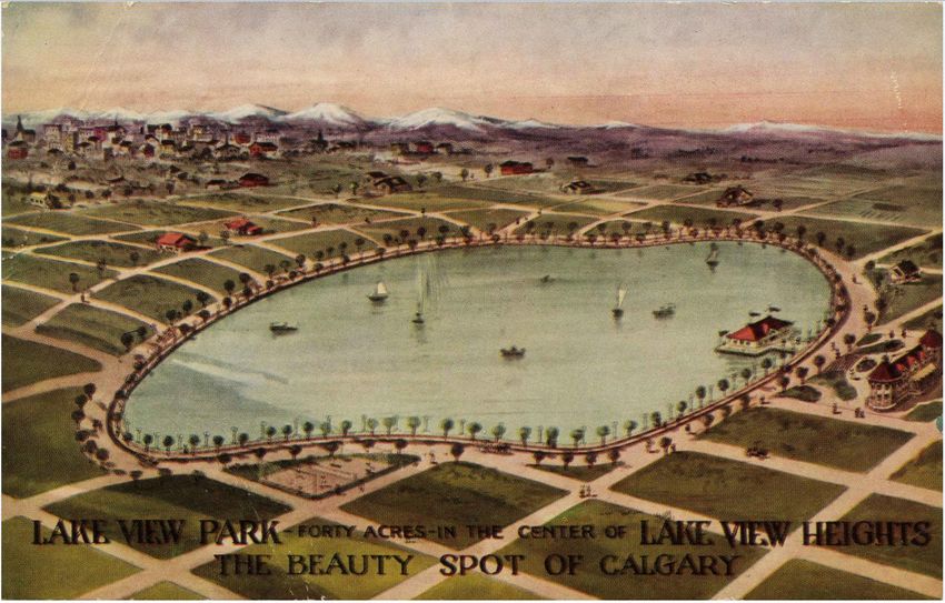
NUMBER 164 / WINTER 2020                                                 NUMERO 164 / HIVER 2020

The Golden Age of Bird’s-Eye Views and Viewmaking
Bird’s-eye views of cities in the nineteenth-century were frequently employed as a form of popular
art as well as a means of advertising. In Views and viewmakers of urban America, urban planning
historian John W. Reps (1984), noted that, “Land speculators, townsite promotors, and civic
leaders all used urban views to attract people and industry to their communities, often subsidizing
the publication of the views to make wider distribution possible”(p. 4). Of the hundreds of
printed views of the United States and Canada documented by Reps in his book, virtually all
were created using the medium of lithography. Using this process, lithographers transformed
an artist’s drawing into an attractive printed image with sharp lines and precise, crisp details.

Lithographic viewmaking enjoyed its golden age in the U.S. during the twenty-five year
period from 1866 to 1891 but its popularity gradually petered out by the early 1900s. There
wasn’t a single reason that led to the demise of viewmaking and perhaps it simply went out
of style as tastes in popular art changed. A likely contributing factor was that the views
published in the early twentieth-century using “improved” methods of printing (e.g., halftone
screens) were much less attractive as prints than those produced using the lithographic press.

Bird’s-Eye Views and Historical Research
An artistic bird’s eye view portrays a city as if seen from an imaginary viewpoint high up in the
air and shows how a geographic location would have looked at a particular point in time. The usual
process followed by an artist to create one is described by Reps (1984) in this way:
      “The artist, meanwhile, was busy with the arduous task of sketching every building in
      town. Although he may have used whatever elevated viewpoints existed, in most cases
      the artist walked the streets and recorded what he saw in his sketchbook. From a town
      map or, if the place had been platted in the usual checkerboard pattern, from his own
      simple measurements and observations, the artist constructed a perspective grid
      showing the town’s streets. On this he re-drew the buildings from his sketches, taking
      care to make each one the correct size. From this rough sketch of the entire town the
      artist then produced a more finished and attractive drawing” (p. 10).
City street patterns, significant buildings, and topographic features and are often readily
identifiable in bird’s-eye views. In some locales, these maps can be the only available option for
obtaining such details. It is for these reasons that scholars have “…rediscovered these
views as sources for research in the history of architecture, city planning,
transportation, urban geography, printing technology, and other fields” (Reps, 1984, p. 16).

Bird’s-Eye Views of Alberta’s Towns and Cities
In 1976, the Public Archives of Canada held an exhibition entitled Bird’s-Eye Views of
Canadian Cities: An Exhibition of Panoramic Maps (1865-1905). No views from either Alberta
or Saskatchewan appeared in this display of 78 maps from 75 different cites (Fox, 1977).
recently, in her chapter
ISSN 2561-2263                                                                             2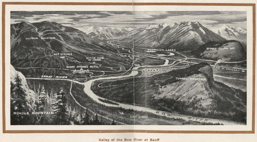
NUMBER 164 / WINTER 2020                                                                     NUMERO 164 / HIVER 2020

More recently, in her chapter on bird’s-eye view maps, Eva
Dodsworth (2018) identified a total of three photolithographic-style
views of Alberta as found in the online collections of the Library of
Congress, Library and Archives Canada, and various university
library holdings. Perhaps due to Alberta’s relatively young age,1 its
widely dispersed population and distant location on Canada’s
western frontier relatively few “classic” lithographic views were
produced      that   pictured    Alberta     cities    and    towns.

Since bird’s-eye views are easily understandable, they were
frequently employed by real estate developers to assist people in the
identification of land locations. If used for such promotional
purposes, a view would typically include other embellishments
hinting at future prosperity (e.g., new subdivisions, bridges,
anticipated railways, streetcar lines, and belching smokestacks) to
entice prospective buyers. Despite there being few bird’s-eye views
of Alberta produced as lithographs, there are plenty of examples of
views created in the 1910s for use in advertising. Production of these
views coincided with the explosive population growth in the
Prairie Provinces that took place as settlers flooded into
Canada’s west. Land developers, real estate promoters and
city boosters realized that these new immigrants would spur demand
for land in Alberta’s towns and cities.                                Cover of What sunny Alberta is
                                                                                          like: A bird's-eye view of Cal-
                                                                                          gary (1911) by H. M. Burton.
Alberta’s Real Estate Advertisers and Artist Entrepreneurs                                Courtesy of University of Cal-
                                                                                          gary Archives and Special Coll-
Fred C. Lowes was Calgary’s most successful land promoter of the                          ections. Image considered to be
early 1910s and was known to spare no expense when it came to                             in the public domain.
advertising his properties for sale (Foran, 1989). He and several of his realtor contemporaries
employed the services of artists to produce illustrations and bird’s-eye view maps to be
incorporated into print advertisements. These views most frequently appeared within newspaper
ads but were also reproduced on handbills, city promotional booklets and souvenir postcards.
Harry Marriott (H. M.) Burton (1882-1979) and Gibson Catlett (1866-1935) were two of the
artists who painted2 many of the bird’s-eye views of Alberta done during the land boom. Burton
was a trained British artist and illustrator who lived in Calgary from 1910 to about 1912. Gibson
Catlett was a self-taught American artist and advertising man who specialized in the production
of city views for real estate sales. He arrived in Calgary in 1911 and set up his studio which
employed trained artists to assist him in the production of these works (Stevens, 2018).

1
  Alberta became a Canadian province on September 1, 1905. Unofficial estimates for the size of its population at that time
range from between 160,000 to 250,000 people.
2
 Gibson Catlett would first sketch city streets and building. Next, his team of artists and colorists would re-create the view
and produce a final painted version.

ISSN 2561-2263                                                                                                      3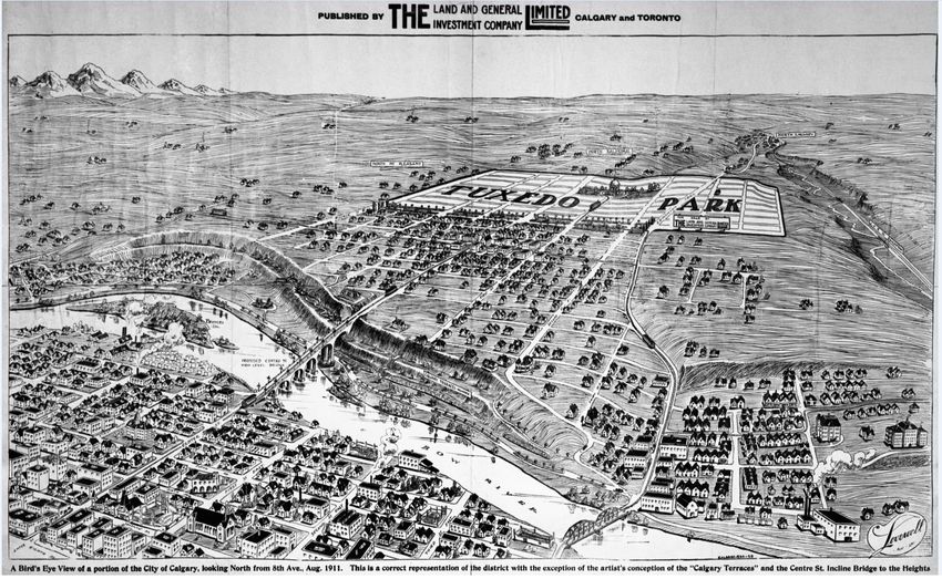
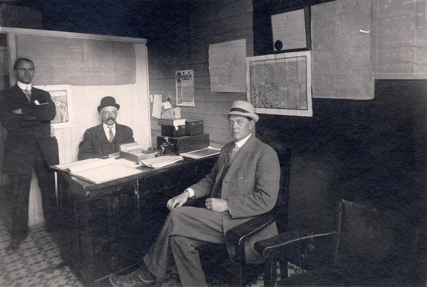
NUMBER 164 / WINTER 2020                                                             NUMERO 164 / HIVER 2020

“Men inside a real estate sales office, possibly Calgary, Alberta”, 1911. [PA-4096-2]. Courtesy of Glenbow Archives,
Archives and Special Collections, University of Calgary. The partially obscured map behind the man standing is
[Bird’s-eye view of Calgary] (1910) by H. M. Burton. The map directly above the seated man is What Sunny Alberta
is Like (1911), also by H. M. Burton.

Alberta’s Promotional Bird’s-Eye Views

The twenty-five views of Alberta’s cities and towns that appear in Appendix A. were all created
between 1910 and 1915 and represent the best examples of this type of work. A majority
of them picture Calgary and region which may have been because the province’s two
most prolific bird’s-eye view artists were based in the city during this time. In addition
to views of Calgary, there are others that show Edmonton, Lethbridge,
Medicine Hat, Banff, Bassano, and Athabasca as they appeared in the 1910s.

ISSN 2561-2263                                                                                             4
NUMBER 164 / WINTER 2020                                               NUMERO 164 / HIVER 2020

                                          References

Dodsworth, E. (2018). A research guide to cartographic resources: Print and electronic sources.
     Lanham, Maryland: Rowman & Littlefield Publishers.

Foran, M. (1989). Fred Lowes: Booster extraordinaire. Alberta History, 37(2), 11-20.
       http://peel.library.ualberta.ca/bibliography/9021.37.2/13.html

Fox, M. F. (1977). Review of [Bird's-Eye Views of Canadian Cities: A Review]. Urban History
      Review / Revue d'histoire urbaine, (1-77), 38–45. https://doi.org/10.7202/1019589ar

Reps, J. W. (1984). Views and viewmakers of urban America: Lithographs of towns and cities in
       the United States and Canada, notes on the artists and publishers, and a union catalog of
       their work, 1825-1925. Columbia: University of Missouri Press.

Stevens, R. M. G. (2018). Who painted the 1912 bird's-eye view of Lethbridge? Lethbridge
       Historical Society Newsletter, 49(3), 3-7. https://hdl.handle.net/10133/5121

ISSN 2561-2263                                                                           5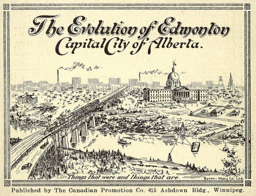
NUMBER 164 / WINTER 2020                                                                    NUMERO 164 / HIVER 2020

                                                   Appendix A
Twenty-Five Examples of Bird’s-Eye Views of Alberta’s Land Boom of the
1910s

1. Burton, H. M. (1910). [Bird’s-eye view of Calgary] [map]. (scale indeterminable). Calgary: Calgary
Engraving Co.

Courtesy of William C. Wonders Map Collection, University of Alberta (ID 29356). Image considered to be in the public domain.

Artist Harry Marriott (H. M.) Burton painted this northward-facing view of Calgary in 19101 which
accurately details the extent of the city and its topography. The map includes labels for railway and streetcar
lines, canals, and trails (roadways) and key industrial areas east of the Bow River. Vast areas of this eastern
periphery around Hubalta and the Canadian Pacific Railway (C.P.R.) Industrial Division lands indicate
where significant future growth was anticipated. Real estate advertisements for Hubalta subdivisions
appearing in the Calgary Herald in late 1910 included illustrations by H. M. Burton. These advertisements
suggest that Burton’s 1910 Calgary view was utilized in promotional real estate campaigns. A reproduction
of this map was published by the Association of Canadian Map Libraries and Archives in 2004. The original
is held at the William C. Wonders Map Collection, University of Alberta in Edmonton.

1
  It was reported in the Calgary Herald (1910, August 16, p. 1) that, “Fifty thousand copies of a birdseye view of the
city and surrounding country, as it will appear in years to come, were ordered [by Calgary City Council] from H. M.
Burton for $2,000.”
ISSN 2561-2263                                                                                                     6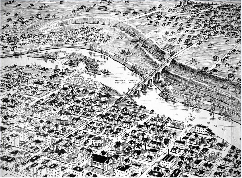
NUMBER 164 / WINTER 2020                                                                      NUMERO 164 / HIVER 2020

2. Canadian Estates Company Limited. (1911). A bird’s eye view of the City of Calgary showing the
location of Tuxedo Park [map]. In J. Ruse and C. A. Owens, The story of Calgary, 1911 and Tuxedo
Park. Calgary: J.O.E Ltd.

Courtesy of University of Calgary Archives and Special Collections. Image considered to be in the public domain.

This northward view of the City of Calgary was one of several that appeared in a promotional booklet
published in 1911 extolling the virtues of Calgary and its new Tuxedo Park subdivision. Tuxedo Park was
owned by the Canadian Estates Co. and its location is clearly identified north of the Bow River along with
the La Grange, Highland Park and North Balmoral developments. Few other features are identified apart
from the Canadian Northern Railway and the Exhibition Grounds. The visible landscape surrounding the
city has been enhanced to make the overall view more attractive. The artist is unknown but the style of this
view resembles those in advertisements2 created by H. M. Burton.

2
    This view was also published as part of an advertisement in the Calgary Herald (1911, April 20, pp. 18-19).
ISSN 2561-2263                                                                                                     7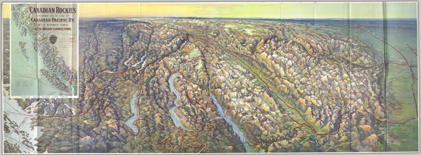
NUMBER 164 / WINTER 2020                                                                      NUMERO 164 / HIVER 2020

3. A topographical view of Tuxedo Park [map]. (1911). In J. Ruse and C. A. Owens, The story of
Calgary, 1911 and Tuxedo Park. Calgary: Land & General Investment Co.

Courtesy of University of Calgary Archives and Special Collections. Image considered to be in the public domain.

This view looks southward from the Tuxedo Park subdivision to Calgary’s downtown business district. It
is one of several views that appeared in a promotional booklet published in 1911 extolling the virtues of
Calgary and advertising Tuxedo Park which was owned by the Canadian Estates Co. Plans for Tuxedo Park
included a pavilion within the centre of “Tuxedo Gardens” which was to be serviced by a new municipal
street railway line. The artist is unknown but this view resembles others produced by H. M. Burton.

ISSN 2561-2263                                                                                                     8
NUMBER 164 / WINTER 2020                                                         NUMERO 164 / HIVER 2020

4. [Advertisement for “West Bridgeland” by Henderson Land Co.]. (1911, September 2). Calgary
Herald, p. 24. https://www.newspapers.com/image/480072223/

Image from historical newspaper content considered to be in the public domain.

Included in a 1911 Calgary Herald newspaper advertisement for the Henderson Land Co.’s “West
Bridgeland” development was this view of Calgary looking north from the downtown business district. This
work resembles the type of bird’s-eye view lithograph that was produced in the 19th century. Street names
are visible as are names of the nearby residential subdivisions of Crescent Heights, Mt. Pleasant, Sereni
Estate, Beaumont and Regal Terrace. This lithograph was produced by the Calgary Engraving Co. but the
artist was not identified.

ISSN 2561-2263                                                                                   9
NUMBER 164 / WINTER 2020                                                                     NUMERO 164 / HIVER 2020

5a. A bird’s eye view of a portion of the City of Calgary, looking North from 8th Ave., Aug. 1911
[advertisement]. (1911, August). Calgary: The Land and General Investment Company Limited. Glenbow
Western Research Centre – University of Calgary, NA-1209-1. https://glenbow.ucalgary.ca/digital/
(Digital Identifier: NA-1209-1)

Courtesy of Glenbow Archives, Archives and Special Collections, University of Calgary. Image considered to be in the public
domain.

This view of Calgary’s central downtown and areas to the north was published as a print advertisement for
the Tuxedo Park subdivision owned by The Land and General Investment Company Limited. Manager of
this company was C. A. Owens who also published the promotional booklet The story of Calgary, 1911
and Tuxedo Park (see views #2 & #3). It is apparent that this view is very similar to the preceding one (#4)
but shows a larger swath of the city and has as its focus the Tuxedo Park land development. This lithograph
was produced by the Calgary Engraving Co. and has the name Lovewell3 at the lower-right corner. The
artist is perhaps H. M. Burton as he produced several other views advertising Tuxedo Park.

3
  Lovewell is probably the name of a real estate agent. A Metzner & Lovewell, Agencies Ltd. advertisement appears
in the Calgary Herald newspaper on January 23, 1912.
ISSN 2561-2263                                                                                                       10
NUMBER 164 / WINTER 2020                                                                     NUMERO 164 / HIVER 2020

5b. A bird’s eye view of a portion of the City of Calgary, looking North from 8th Ave., Aug. 1911 [close-
up of advertisement]. (1911, August). Calgary: The Land and General Investment Company Limited.
Glenbow Western Research Centre – University of Calgary, NA-1209-2.
https://glenbow.ucalgary.ca/digital/ (Digital Identifier: NA-1209-2)

Courtesy of Glenbow Archives, Archives and Special Collections, University of Calgary. Image considered to be in the public
domain.

Street names and building details can be clearly made out in this close-up of view #5a which encompasses
the area of what is today the City of Calgary’s central downtown.

ISSN 2561-2263                                                                                                       11
NUMBER 164 / WINTER 2020                                                                     NUMERO 164 / HIVER 2020

6. Catlett, G. (1911). The City of Calgary 1911 showing the superb residential properties owned and
for sale by F. C. Lowes & Co. [map]. In Jennings Publishing Company, Merchants and manufacturers
record: Calgary, sunny Alberta, the industrial prodigy of the great west. Calgary: Author. (p. 95).
https://archive.org/details/calgarysunnyalbe00jenn/page/94/mode/2up

Courtesy of Internet Archive, Uploaded by Queen's University Library. Image considered to be in the public domain.

In 1911 a “souvenir book” containing more than three hundred photographs of Calgary was produced by
the Jennings Publishing Company to “…truthfully represent the City of Calgary, and show what the city
really has to offer the homeseeker, investor, merchant and manufacturer.” Included was the above view
produced by American “topographic artist” Gibson Catlett for real estate developer Fred Lowes of F. C.
Lowes & Co., then considered the city’s most successful real estate investor. This view was first
produced by Catlett as a painting for the F. C. Lowes and Co. exhibit at Calgary’s first annual
land show in November, 1911.4 The focus of this north-facing view are Lowes’ extensive
Calgary landholdings which included properties for sale in the subdivisions of Bow Park,
Elbow Park, Rideau Park and Roxborough Place, Stanley Park, Brittania, and Windsor Park.

4
  The Calgary Herald (1913, November 13, p. 13) reported there was, “…a huge landscape painting of the city, four
feet by ten feet, executed by Gibson Catlett, which cost $1,000. The picture shows every building in the city on
canvass, and an excellent view of the Rocky mountains can be seen.”
ISSN 2561-2263                                                                                                       12
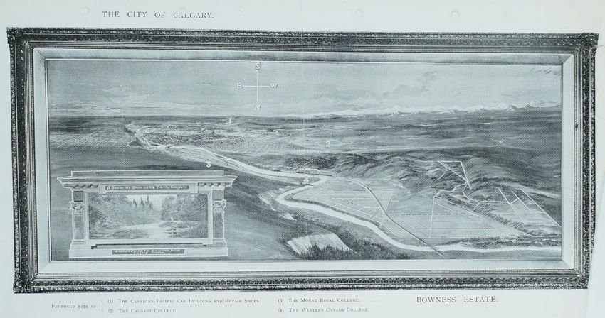
NUMBER 164 / WINTER 2020                                                                   NUMERO 164 / HIVER 2020

7. Catlett, G. (ca. 1911). The City of Calgary. Bowness Estate [advertisement showing painting]. Board
of Trade: Companies Registration Office: Files of Dissolved Companies fonds (Company No: 121035;
Bowness Estates Ltd. BT 31/20554). The National Archives, Kew, U.K.

Courtesy of The National Archives [U.K.]. Permission received from The National Archives [U.K.] to reproduce image.

Developer John Hextall had grand visions of turning his Bowness-area landholdings into an exclusive
residential subdivision for Calgary, located six miles to the east. This advertisement contains a
reproduction of a painting by Gibson Catlett, topographic artist, showing the proposed
Bowness Estate subdivision in 1911.5 The inset displays “A Scene in Bowness Park, Calgary.”
The numbers on the painting indicate the proposed sites of (1) The Canadian Pacific Car Building and
Repair Shops; (2) The Calgary College; (3) The Mount Royal College, and; (4) The Western Canada
College.

5
 In reporting about the J. Hextall exhibit at Calgary’s first annual land show, the Calgary Herald (1911, November
13, p. 13) mentioned that, “A large painting of the [Bowness] district was executed by Gibson Catlett, the well
known American artist.”
ISSN 2561-2263                                                                                                    13
NUMBER 164 / WINTER 2020                                                           NUMERO 164 / HIVER 2020

8. Lake View Park, forty acres, in the center of Lake View Heights, the beauty spot of Calgary
[postcard]. (ca. 1912). Calgary: A. O. Jennings & E. J. Foster. Postcards From the Past, Calgary Public
Library, PC_925. http://cdm16114.contentdm.oclc.org/cdm/ref/collection/p280501coll15/id/2843

Courtesy of Calgary Public Library. Image considered to be in the public domain.

Calgary realtors A. O. Jennings and E. J. Foster offered this postcard showing a view of the proposed Lake
View Park to anyone visiting their properties for sale in Lake View Heights. This subdivision appears to
have been a district registered and approved by the city but never developed. Lake View Heights was to be
located three miles northeast from Calgary’s post office.

ISSN 2561-2263                                                                                     14
NUMBER 164 / WINTER 2020                                                                      NUMERO 164 / HIVER 2020

SOUTHERN ALBERTA

9. Burton, H. M. (1911). What sunny Alberta is like: A birdseye view of Calgary with the surrounding
& tributary country & interesting facts concerning the banner province of Canada [map]. Calgary:
Calgary Engraving Co. https://www.bac-
lac.gc.ca/eng/CollectionSearch/Pages/record.aspx?app=fonandcol&IdNumber=4155910

Courtesy of University of Calgary Archives and Special Collections. Image considered to be in the public domain.

This map by artist H. M. Burton shows a panoramic bird’s-eye view of the entirety of Alberta south of
Edmonton as well as the southeastern portion of British Columbia as far as Cranbrook. It was published in
19116 as the main feature of Calgary promotional folder entitled What sunny Alberta is like. Cities, towns
and First Nation reserves throughout the province are labelled. Railways, projected railways, rivers and
canals are prominently displayed.

6 In the Calgary Herald newspaper article, “A Birdseye View of Calgary District” (1910, August 22, p. 3), it was reported
that, “The physical features of the country west as far as Fernie and Cranbrook, east as far as Medicine Hat, north as far as
Edmonton, and south to the boundary, will be fully described and illustrated in the special map H. M. Burton is preparing
for the city. This map will be printed on a folder, and 50,000 of these will be available for distribution for advertising
purposes. The whole will be in the form of a birdseye view, showing the nature of the ground, where rolling, hilly, or flat
prairie, the rivers, highways, cities, towns and villages, etc. "What Southern Alberta Looks Like," is the subject of the
folder.”
ISSN 2561-2263                                                                                                     15
NUMBER 164 / WINTER 2020                                                               NUMERO 164 / HIVER 2020

10. Catlett, G. (n.d.). Topographic landscape, irrigation block of the Canadian Pacific Railway,
Alberta, Canada. [tempera painting]. Object 60.17, Glenbow Museum Art Collection, Calgary, AB.

Courtesy of Glenbow Museum, Calgary. Permission received from Glenbow Museum, Calgary to reproduce image.

This large tempera painting by Gibson Catlett, topographic artist, displays the western, central and eastern
sections of the Irrigation Block of the Canadian Pacific Railway. The cities of Calgary, Edmonton and
Medicine Hat are visible along with an intricate network of irrigation canals. A Glenbow Archives fond
description7 indicates that the colonization of the Irrigation Block was originally administered by the CPR
Land Department’s Calgary office. In 1912, this responsibility was transferred to the Department of Natural
Resources. This painting was likely used to promote settlement within the CPR’s southern Alberta
landholdings.

7
 glen-564 - Canadian Pacific Railway Land Settlement and Development fonds
(https://albertaonrecord.ca/canadian-pacific-railway-land-settlement-and-development-fonds)
ISSN 2561-2263                                                                                              16
NUMBER 164 / WINTER 2020                                                                     NUMERO 164 / HIVER 2020

11. Burton & Gove. (ca. 1911). [Advertisement for development in industrial section of Calgary,
Alberta]. Calgary: Author. Glenbow Western Research Centre – University of Calgary, NA-4562-1.
https://glenbow.ucalgary.ca/digital/ (Digital Identifier: NA-4562-1)

Courtesy of Glenbow Archives, Archives and Special Collections, University of Calgary. Image considered to be in the public
domain.

This view was created by artists Burton and Gove in about 1911 to advertise real estate for sale east of
Calgary towards Chestermere Lake.8 It highlights numerous proposed industrial developments (e.g.,
Pioneer Tractor Co. Plant, Great Northern Addition Div. No. 1 & 2, C.P.R. Shop) and railway routes that
would enhance the appeal of properties for sale in this area.

8
 Chestermere Lake is a man-made reservoir that was built as a “balancing pool” in the CPR’s Western Irrigation
System.
ISSN 2561-2263                                                                                                       17
NUMBER 164 / WINTER 2020                                                                      NUMERO 164 / HIVER 2020

12. Burton, H. M. (ca. 1911). [Advertisement for Chestermere Heights]. Calgary: Calgary Engraving Co.

Courtesy of Chestermere Historical Foundation. Image considered to be in the public domain.

This westward-facing view drawn by H. M. Burton in about 1911 was produced as an advertisement
showing the location of the Chestermere Heights real estate development. A streetcar line between Calgary
and Chestermere Lake shown on this view was proposed but never built.

ISSN 2561-2263                                                                                                18
NUMBER 164 / WINTER 2020                                                         NUMERO 164 / HIVER 2020

13. Burton & Gove. (1912, April 9). [Advertisement for Chestermere Lake by The Chestermere-
Calgary Townsite and Development Co., Limited]. Calgary Herald, p. 15.
https://www.newspapers.com/image/481560970/ & https://glenbow.ucalgary.ca/digital/ (Digital
Identifier: NA-4421-1)

Image from historical newspaper content considered to be in the public domain.

The view was produced by artists Burton and Gove in about 1911 and appeared as part of a Chestermere-
Calgary Townsite and Development Co., Limited newspaper advertisement in the Calgary Herald. As
was the case for many real estate advertisements, grand developments such as the Chestermere Aquatic
Club and the suburban railway were never built.

ISSN 2561-2263                                                                                   19
NUMBER 164 / WINTER 2020                                                          NUMERO 164 / HIVER 2020

14. Burton & Gove. (1912, March 26). [Advertisement for Bassano Heights]. Calgary Herald, pp. 18-
19. https://www.newspapers.com/image/481555471/

Image from historical newspaper content considered to be in the public domain.

A Calgary Herald newspaper advertisement for Bassano Heights in Bassano, Alberta appeared in 1912 and
contained this view by artists Burton and Gove.9 Alberta real estate developers would promote real estate
sales even in smaller towns if the land happened to be advantageously located close to major railway lines.
Bassano’s proximity to the main line of the Canadian Pacific Railway between Calgary and Medicine Hat
and its soon-to-be-built “Horse Shoe Bend” dam were prominently mentioned in the text of the
advertisement. Interestingly, the ad’s promotional slogan “best in the west by a dam site” remains in use
today by the Bassano town office.

9
 According to the advertisement, “The picture was sketched last Saturday by H. M. Burton, the well-known Calgary
artist, who was instructed to reproduce the view exactly and proportionately as regards location and
surroundings.”
ISSN 2561-2263                                                                                         20
NUMBER 164 / WINTER 2020                                                                     NUMERO 164 / HIVER 2020

15. Burton, H. M. (1911). Hutton, the golden grain town of sunny Alberta [advertisement]. In Jennings
Publishing Company, Merchants and manufacturers record: Calgary, sunny Alberta, the industrial
prodigy of the great west. Calgary: Author. (p. 146).
https://archive.org/details/calgarysunnyalbe00jenn/page/146/mode/2up

Courtesy of Internet Archive, Uploaded by Queen's University Library. Image considered to be in the public domain.

This view of Hutton, Alberta drawn by H. M. Burton was included in the 1911 “souvenir book” produced
by the Jennings Publishing Company to promote the City of Calgary. Hutton’s location close to the C.P.R.
Irrigation Block, Red Deer River and local coal mines hint at the region’s enormous agricultural and
industrial potential. The advertisement accompanying the view stated that Hutton was 85 miles due east of
Calgary and close to a route surveyed by the Grand Trunk Pacific Railway.

ISSN 2561-2263                                                                                                       21
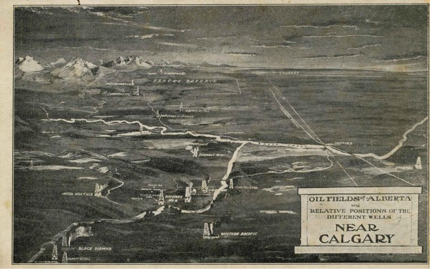
NUMBER 164 / WINTER 2020                                                           NUMERO 164 / HIVER 2020

16. Oil fields of Alberta and relative positions of different wells near Calgary [postcard]. (n.d).
Postcards From the Past, Calgary Public Library, PC_1107.
http://cdm16114.contentdm.oclc.org/cdm/ref/collection/p280501coll15/id/2626

Courtesy of Calgary Public Library. Image considered to be in the public domain.

Alberta’s speculative real estate land boom of the 1910s peaked in 1912 and went bust in 1913. The
province’s fortunes were quickly revived when, on May 14, 1914 the Dingman Number One Well struck
oil in Turner Valley and kicked off the province’s first oil boom. This postcard view by an unknown artist
identifies company names and oil well locations in Turner Valley, Alberta. Identifiable names of oil wells
are Dingman Nos. 1 & 2, Black Diamond, Commercial, Western Pacific and United Oils of Alta. The
relative positions of the City of Calgary, Okotoks and the Sarcee Reserve are also shown. This postcard
may have been used in advertising to sell oil company shares to prospective investors.

ISSN 2561-2263                                                                                        22
NUMBER 164 / WINTER 2020                                                       NUMERO 164 / HIVER 2020

LETHBRIDGE, ALBERTA

17. Catlett, G. (1912). City of Lethbridge. [oil painting]. Object 1971.2, University of Lethbridge Art
Gallery Collection, Lethbridge, AB.
https://opus.uleth.ca/bitstream/handle/10133/5121/Painting%2019712%20%28002%29

Courtesy of University of Lethbridge Art Gallery.

This large oil painting (42 in by 108 in) was created in 1912 by Gibson Catlett studios in Calgary, Alberta
at a cost of $1,000 to advertise a real estate development in Lethbridge, Alberta called Dominion Square.
The subdivision was extensively promoted by Mitford & Co. Real Estate in the Lethbridge Herald
newspaper. A copy of the painting also appeared in a sales brochure advertising Lethbridge real estate and
the city’s coal mining industry.

ISSN 2561-2263                                                                                     23
NUMBER 164 / WINTER 2020                                                         NUMERO 164 / HIVER 2020

MEDICINE HAT, ALBERTA

18. [Advertisement for Ashton Place sub-division, Medicine Hat, Alta. By F. C. Lowes &
Company]. (1913, March 10). Calgary Herald, p. 15. https://www.newspapers.com/image/480310061/

Image from historical newspaper content considered to be in the public domain.

This view of the Ashton Place subdivision in Medicine Hat, Alberta appeared in a Calgary Herald (1913,
March 10, p. 15) newspaper advertisement. A separate ad in the Medicine Hat News (1913, March 18, p.
8) showed this development from a southward-facing direction. Yet another view in the Edmonton Journal
(1913, March 7, p. 10) featured a billowing smokestack that seemed designed to call attention to the
burgeoning industrial development taking place in the city. Property owner Fred Lowes of the F. C. Lowes
& Company was Alberta’s foremost promoter of land sales and had offices in Medicine Hat, Calgary,
Edmonton, Lethbridge and even as far afield as London, England. The artist who produced this view is
unknown though it seems plausible that it was Gibson Catlett studios as Catlett had previously produced
other views for Lowes.

ISSN 2561-2263                                                                                   24
NUMBER 164 / WINTER 2020                                                                      NUMERO 164 / HIVER 2020

EDMONTON, ALBERTA

19. Catlett, G. (ca. 1912). Panoramic view of Edmonton, Canada showing subdivisions owned or sold
by B. F. Blackburn Co., 646 First St. Edmonton [postcard]. Brantford, ON: Stedman Bros. Limited.
Peel’s Prairie Provinces, University of Alberta Libraries, Postcard 13652.
http://peel.library.ualberta.ca/PC/013/PC013652

Courtesy of Peel’s Prairie Provinces, University of Alberta Libraries (CC BY-NC 3.0). Image considered to be in the public
domain.

Edmonton real estate agents also used the services of viewmakers to promote land sales in the Alberta’s
capital city. This view appeared on a 1912 postcard which incorporated a reproduction of a landscape
painting by Gibson Catlett 10 advertising the Grossdale subdivision owned by B. F. Blackburn Co. In 1912,
Grossdale was on the Edmonton’s southern fringes in the recently-annexed community of Strathcona.
Visible landmarks in this north-facing view include the University of Alberta campus, the High Level
Bridge across the North Saskatchewan River, and the distinctive Alberta Legislature Building.

10
  The logo on the lower-right of the image is not legible but is typical of what appeared on Gibson Catlett’s real
estate landscape paintings. This large painting of Edmonton featuring the Grossdale subdivision was on display in a
storefront window according to an article in the Edmonton Journal (1912, February 3, p.11).
ISSN 2561-2263                                                                                                        25
NUMBER 164 / WINTER 2020 NUMERO 164 / HIVER 2020
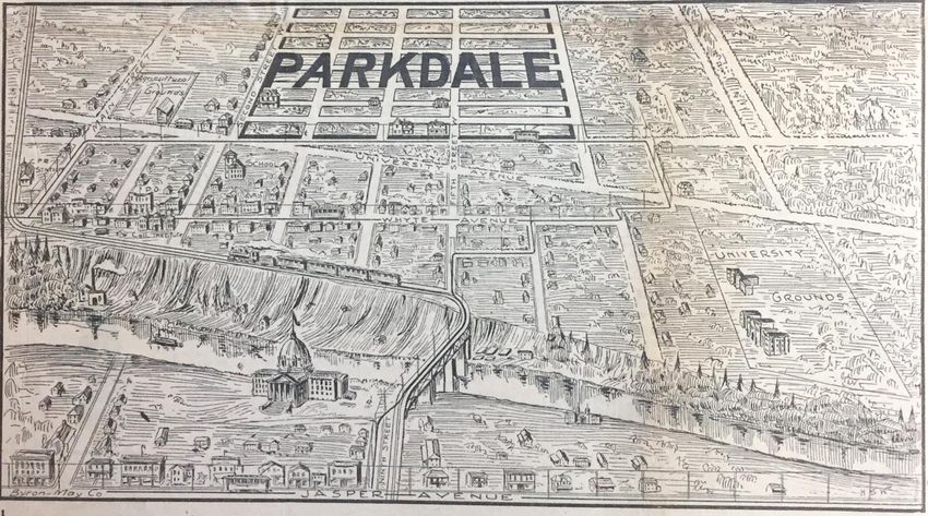
20. Byron-May Co. Ltd. & Whitehorne, H. S. (1911, August 12). Buy a home in “Parkdale”
(Strathcona) the place of opportunities [advertisement]. Edmonton Journal, p. 5.
https://www.newspapers.com/image/468763870/
Image from historical newspaper content considered to be in the public domain.
An Edmonton Journal newspaper advertisement for the Parkdale subdivision in Strathcona11 includes this
lithographic-style view. It shows an area south of Jasper Avenue (Edmonton’s main street) looking across
the North Saskatchewan River toward Strathcona. The view highlights Parkdale’s proximity to Jasper
Avenue, Whyte Avenue, streetcar services, the University Grounds and the Alberta Legislature Building.
The initials “H S W” appear in the lower-right corner of the image and would indicate the artist responsible
for creating the lithographic version of this view. Henderson’s 1912 Edmonton City Directory lists H.
Stanley Whitehorne, artist, as an employee of Byron-May Co.
11
Strathcona was annexed by Edmonton in 1912.
ISSN 2561-2263 26NUMBER 164 / WINTER 2020 NUMERO 164 / HIVER 2020 21. Byron-May Co. Ltd. & Whitehorne, H. S. (1913). The evolution of Edmonton, capital city of Alberta [booklet]. Winnipeg: The Canadian Promotion Co. Peel’s Prairie Provinces, University of Alberta Libraries, Postcard 6361. http://peel.library.ualberta.ca/postcards/PC006361.html Courtesy of Peel’s Prairie Provinces, University of Alberta Libraries (CC BY-NC 3.0). Image considered to be in the public domain. This view of central Edmonton comes from the cover of a promotional “souvenir booklet” of printed photographs of the city published in 1913. The statement “Things that were and things that are” seems to refer to the contrast between newer structures (e.g., High Level Bridge, Alberta Legislature Building) and those that were already quite old (e.g., the Hudson’s Bay Co. Fort which shared the grounds of the Legislature until it was torn down entirely in 1915). Byron-May Co.’s artist H. Stanley Whitehorne probably created the lithographed version of this view as the initials “H S W” appear in the lower-left corner of the image. ISSN 2561-2263 27
NUMBER 164 / WINTER 2020                                                                  NUMERO 164 / HIVER 2020

NORTHERN ALBERTA
22a. Athabasca Land Company (1911, July 12). Gateway Heights, Athabasca Landing, “Where rail and
water meet.” [newspaper advertisement]. Glenbow Western Research Centre – University of Calgary,
NA-2092-1. https://glenbow.ucalgary.ca/digital/ (Digital Identifier: NA-2092-1).

                                                                             Steamships can be seen plying the
                                                                             waters of the Athabasca River in this
                                                                             view from 1911 which appeared in a
                                                                             newspaper advertisement promoting
                                                                             the Gateway Heights subdivision for
                                                                             the Athabasca Land Company.
                                                                             Athabasca Landing (today known as
                                                                             Athabasca) experienced a population
                                                                             and land boom between 1906 and 1914
                                                                             which was in part due to the arrival in
                                                                             1912 of Canadian National Railway
                                                                             tracks to the village. It was anticipated
                                                                             that Athabasca Landing would become
                                                                             a key rail and river freight junction for
                                                                             Alberta’s Peace Country to the
                                                                             northwest as well as Fort McMurray to
                                                                             the northeast.

Courtesy of Glenbow Archives, Archives and Special Collections, University
of Calgary. Image considered to be in the public domain.

ISSN 2561-2263                                                                                                 28
NUMBER 164 / WINTER 2020 NUMERO 164 / HIVER 2020 22b. Athabasca Land Company (1911, July 12). Gateway Heights, Athabasca Landing, “Where rail and water meet.” [close-up of newspaper advertisement]. Glenbow Western Research Centre – University of Calgary, NA-2092-2. https://glenbow.ucalgary.ca/digital/ (Digital Identifier: NA-2092-2). Courtesy of Glenbow Archives, Archives and Special Collections, University of Calgary. Image considered to be in the public domain. This is a close-up of view #22a. The Canadian National Railway tracks and depot is prominent in this 1911 view though it was not completely built until 1912. ISSN 2561-2263 29
NUMBER 164 / WINTER 2020                                                         NUMERO 164 / HIVER 2020

23. McCutcheon Bros. (1911, June 3). Athabasca Landing, where rail meets sail, Gateway Heights
[advertisement]. Calgary Daily Herald, p. 12. https://www.newspapers.com/image/481611380/

Image from historical newspaper content considered to be in the public domain.

This view is from a Calgary Herald newspaper advertisement for the Gateway Heights subdivision in
Athabasca Landing being promoted by McCutcheon Bros., Calgary. The region’s abundant natural resource
industries and anticipated railway lines are prominently displayed.

ISSN 2561-2263                                                                                   30
NUMBER 164 / WINTER 2020                                                                     NUMERO 164 / HIVER 2020

CANADIAN ROCKY MOUNTAINS

24. Valley of the Bow River at Banff [map]. (ca. 1915). In Canadian Pacific Railway Company, Resorts
in the Canadian Rockies. (p. 2). The Chung Collection, Rare Books and Special Collections, University
of British Columbia Library (CC_TX_200_008_004_002). https://dx.doi.org/10.14288/1.0229044

Permission received to reproduce image courtesy of Rare Books and Special Collections, University of British Columbia Library.

The pamphlet Resorts in the Canadian Rockies was used in about 1915 to advertise C.P.R.-owned hotels.
It contains a map of the Valley of the Bow River at Banff, Alberta. The view shown in this tourist map
identifies Banff’s main attractions and the castle-like Banff Springs Hotel. The artist who created this view
is unknown but its style is similar to those done by Gibson Catlett.

ISSN 2561-2263                                                                                                      31
NUMBER 164 / WINTER 2020                                                                     NUMERO 164 / HIVER 2020

25. Canadian Rockies showing main line of Canadian Pacific Ry. with branch lines & steamship
connections. [map]. (ca. 1915). In Canadian Pacific Railway Company, Resorts in the Canadian Rockies.
(p. 26). The Chung Collection, Rare Books and Special Collections, University of British Columbia
Library (CC_TX_200_008_004_019). https://dx.doi.org/10.14288/1.0229044

Permission received to reproduce image courtesy of Rare Books and Special Collections, University of British Columbia Library.

A large colour fold-out map was included within the pamphlet entitled Resorts in the Canadian Rockies
used to advertise C.P.R.-owned railways and hotels in about 1915. The map shows a panoramic bird’s-eye
view of the southern half of Alberta and British Columbia from Victoria, B.C. to Calgary, Alberta. C.P.R.
and steamship lines are displayed prominently.

ISSN 2561-2263                                                                                                      32
You can also read