Celtic Interconnector - Volume 4 - Appendix 1 6C Marine Archaeology Written Scheme of Investigation June 2021
←
→
Page content transcription
If your browser does not render page correctly, please read the page content below
Celtic Interconnector
Volume 4 – Appendix 16C
Marine Archaeology Written Scheme of Investigation
June 2021
Celtic Interconnector                                                                                                        EIAR
                                                                                                     Written Scheme of Investigation

                                                                         Copyright and non-disclosure notice
Report for                                                               The contents and layout of this report are subject to
                                                                         copyright owned by Wood (© Wood Group UK Limited)
EirGrid plc and Réseau de Transport d’Électricité                        save to the extent that copyright has been legally assigned
                                                                         by us to another party or is used by Wood under licence.
                                                                         To the extent that we own the copyright in this report, it
                                                                         may not be copied or used without our prior written
                                                                         agreement for any purpose other than the purpose
                                                                         indicated in this report. The methodology (if any)
Main contributors                                                        contained in this report is provided to you in confidence
                                                                         and must not be disclosed or copied to third parties
                                                                         without the prior written agreement of Wood. Disclosure of
                                                                         that information may constitute an actionable breach of
                                                                         confidence or may otherwise prejudice our commercial
                                                                         interests. Any third party who obtains access to this report
Issued by                                                                by any means will, in any event, be subject to the Third
                                                                         Party Disclaimer set out below.

                  ....................................................
                                                                         Third party disclaimer
                                                                         Any disclosure of this report to a third party is subject to
                                                                         this disclaimer. The report was prepared by Wood at the
                                                                         instruction of, and for use by, our client named on the front
Approved by                                                              of the report. It does not in any way constitute advice to
                                                                         any third party who is able to access it by any means.
                                                                         Wood excludes to the fullest extent lawfully permitted all
                                                                         liability whatsoever for any loss or damage howsoever
                                                                         arising from reliance on the contents of this report. We do
                          ...........................................    not however exclude our liability (if any) for personal injury
                                                                         or death resulting from our negligence, for fraud or any
                                                                         other matter in relation to which we cannot legally exclude
                                                                         liability.

Wood                                                                     The sole responsibility of this publication lies with the
                                                                         author. The European Union is not responsible for any use
Doc Ref. 43171-WOOD-XX-XX-TN-OH-0001_CR_P02                              that may be made of the information contained therein.

                                                                         Management systems
                                                                         This document has been produced by Wood Group UK
                                                                         Limited in full compliance with our management systems,
                                                                         which have been certified to ISO 9001, ISO 14001 and
                                                                         ISO 45001 by Lloyd's Register.

June 2021
                                                                                                                                   2
Celtic Interconnector                                                                                                        EIAR
                                                                                                     Written Scheme of Investigation

Table of Contents
1    Introduction ................................................................................................................. 5
  1.1      Purpose of this document ...................................................................................... 5
  1.2      Structure ................................................................................................................ 5
  1.3      Project Overview ................................................................................................... 5
  1.4      Geographical scope ............................................................................................... 9
2    Aims and Objectives ................................................................................................. 10
  2.1      Aim ...................................................................................................................... 10
  2.2      Objectives............................................................................................................ 10
3    Roles and Responsibilities ....................................................................................... 11
  3.1      Project roles and responsibilities are defined as set out at Table 3.1. .................. 11
  3.2      Liaison with Regulators........................................................................................ 12
4    Baseline Summary .................................................................................................... 14
  4.1      Previous archaeological work .............................................................................. 14
  4.2      Marine Archaeological remains ............................................................................ 16
  Irish TW and EEZ ........................................................................................................... 16
     UK EEZ ....................................................................................................................... 17
5    Proposed Mitigation .................................................................................................. 19
  5.1      Introduction.......................................................................................................... 19
  5.2      Marine Archaeological Remains .......................................................................... 19
     Review of Marine Geophysical Surveys ...................................................................... 19
     Archaeological assessment of ROV survey data ......................................................... 20
  5.3      Archaeological Exclusion Zones .......................................................................... 21
  5.4      Protocol for Archaeological Discoveries ............................................................... 23
     General ....................................................................................................................... 23
     Provision of archaeological advice .............................................................................. 25
     Revision or establishment of AEZ................................................................................ 25
     Reporting of findings ................................................................................................... 26
6    Procedures in respect of statutorily protected remains ......................................... 27
  6.1      General................................................................................................................ 27
  6.2      Archaeological Material ....................................................................................... 27
     Irish TW and EEZ ........................................................................................................ 27
     UK EEZ ....................................................................................................................... 28
  6.3      Human remains ................................................................................................... 28
     General ....................................................................................................................... 28
     Irish Territorial Waters and EEZ .................................................................................. 28
     UK EEZ ....................................................................................................................... 29
     Military Remains .......................................................................................................... 29
7    Post-Excavation and Reporting ............................................................................... 30
  7.1      General................................................................................................................ 30
  7.2      Reporting of pre-construction surveys ................................................................. 30
  7.3      Post-Fieldwork Reporting .................................................................................... 30

June 2021
                                                                                                                                    3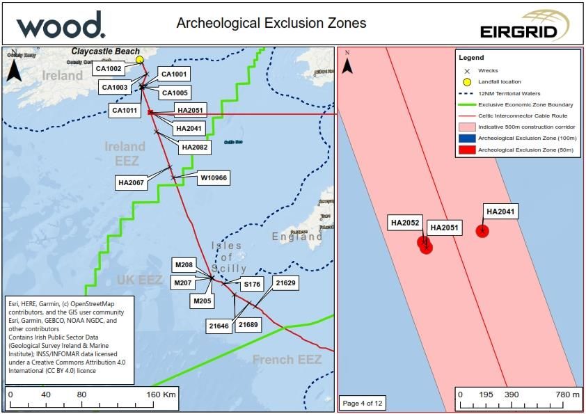
Celtic Interconnector                                                                                                     EIAR
                                                                                                  Written Scheme of Investigation

  7.4   OASIS ................................................................................................................. 31
  7.5   Permanent Archival and Storage ......................................................................... 31
8   Conclusion................................................................................................................. 33
9   References ................................................................................................................. 34
10 Appendix A: PAD Flow Diagram .............................................................................. 35
11 Appendix B: Plans of AEZ ........................................................................................ 36

June 2021
                                                                                                                               4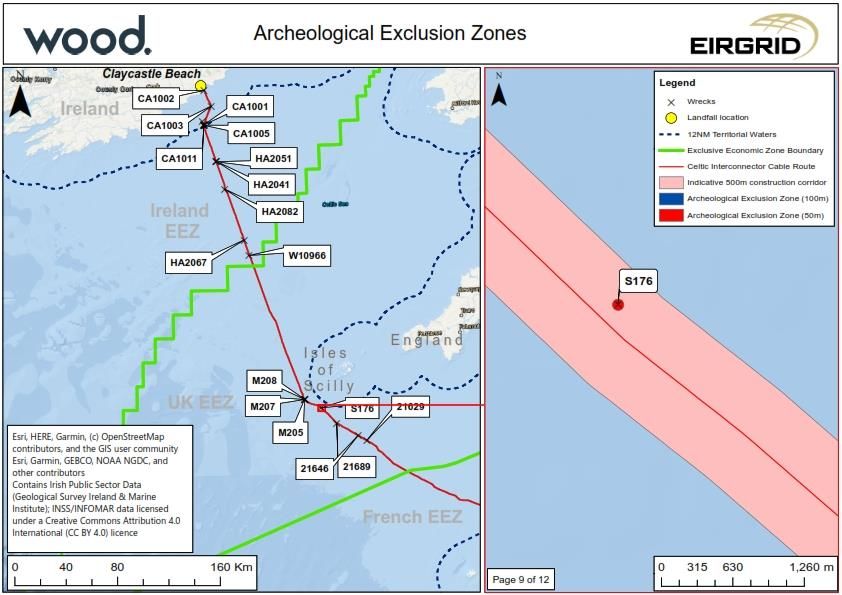
Celtic Interconnector                                                                           EIAR
                                                                        Written Scheme of Investigation

1     Introduction

1.1       Purpose of this document
This Written Scheme of Investigation (WSI) sets out mitigation procedures in respect of
known and potential archaeological remains and deposits of geoarchaeological interest that
may be affected by the construction of the proposed Celtic Interconnector Project within the
Irish Territorial Waters (TW) and Exclusive Economic Zone (EEZ) and the UK EEZ.
This WSI identifies aims of the marine investigations, the generic methodologies and
relevant standards of the offshore mitigation strategy referenced in the Environmental
Impact Assessment Report (EIAR) and Environmental Report (ER). It conforms to current
best practice as set out by guidance from the relevant national regulators, The National
Monuments Service (NMS) and Historic England (HE), and the relevant guidance from the
appropriate national professional bodies, the Institute of Archaeologists of Ireland (IAI) and
Chartered Institute for Archaeologists (CIfA), as appropriate.
The results of previous phases of consultation on the development proposals and the
approach and findings of the assessment with the relevant regulators has been taken into
account in producing these proposals for mitigation, and further consultation will be
undertaken with the Cork Heritage Officer, the Underwater Archaeology Unit of the National
Monuments Service, and Historic England to agree the provisions set out prior to the
commencement of any investigative or construction work.
This WSI excludes archaeological investigation of deposits of geoarchaeological significance
above LAT at Claycastle. Any works carried out in mitigation of disturbance of these
deposits would be carried out under licence from the NMS to standards set out and agreed
through the licensing process.
This WSI also excludes geoarchaeological investigations within the marine zone, which
would be carried out under the terms of an Offshore Project Environmental Remains
Strategy that would be agreed with the relevant national regulators.
1.2       Structure
This WSI sets out the project background and geographical scope (Section 1), aims and
objectives of archaeological works (Section 2), roles and responsibilities (Section 3),
archaeological background (Section 4), followed by scope and standards for archaeological
mitigation (Section 5) of Marine Archaeological Remains (Section 5.4). Initial Archaeological
Exclusion Zones (AEZ) are identified (Section 5.5). A Protocol for Archaeological
Discoveries (PAD: Section 5.6) is set out. Procedures in respect of statutorily designated
remains (Section 6) and for archaeological reporting and archival (Section 7) are set out.
1.3       Project Overview
The Celtic Interconnector Project is a joint project being developed by Réseau de Transport
d’Electricité (RTE) and EirGrid and is being supported by the European Union’s Connecting

June 2021
                                                                                                   5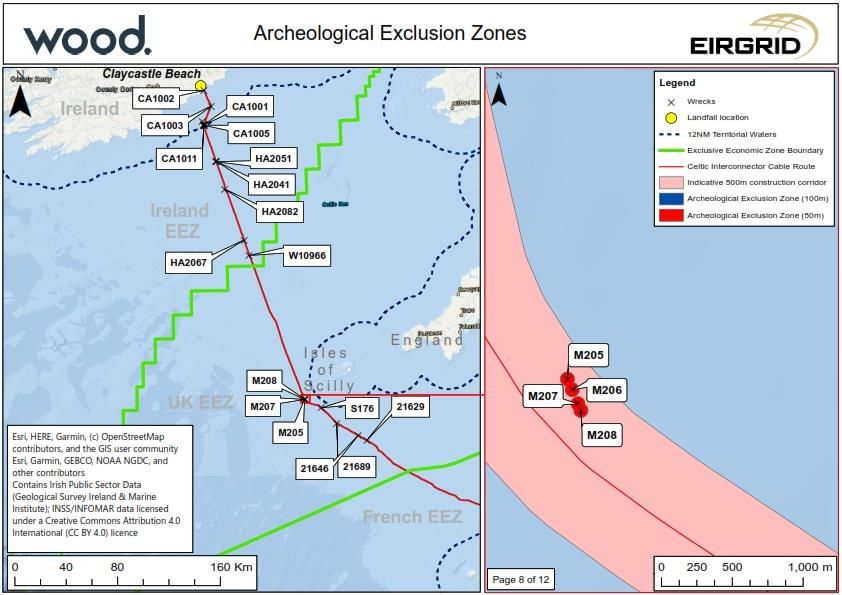
Celtic Interconnector EIAR
Written Scheme of Investigation
Europe Facility (CEF). It is also a European Union Project of Common Interest (PCI) and a
designated e-Highway 2050 project.
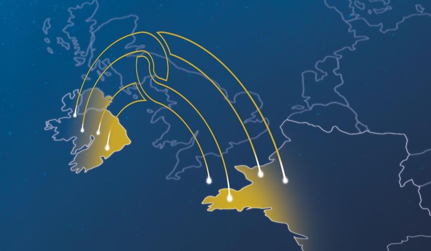
The project involves the construction of an electrical circuit between Ireland and France
using High Voltage Direct Current (HVDC) technology, the global standard for the transfer of
electricity over long distances using underground technology. The interconnector would
have a capacity of 700MW (equivalent to the power used by approximately 450,000 homes)
and measures approximately 575km in length. The longest spatial element of the Celtic
Interconnector would be the submarine circuit which would measure approximately 497km
out of the total 575km. The interconnector would form a link between County Cork on the
south coast of Ireland and the coast of Brittany in North West France (Nord-Finistère).
The main elements of the interconnector are illustrated in Figure 1.1 and consist of:
• A submarine circuit, approximately 497km in length placed on or beneath the
seabed between France and Ireland. The submarine circuit will pass though the
territorial waters of Ireland and France and through the Exclusive Economic
Zones (EEZs) of Ireland, the UK and France, as shown in Figure 1.2;
• The cable route within the UK EEZ passes approximately 30km to the west of the
Isles of Scilly and approximately 75km to the west of Land’s End on the UK
mainland
• A landfall point where the submarine circuit comes onshore, in France and
Ireland;
• A HVDC land circuit between the landfall point and a converter station, in France
and Ireland;
• A converter station, to convert the electricity from HVDC to High Voltage
Alternating Current (HVAC), which is used on the respective transmission grids in
each country;
• A HVAC land circuit between the converter station and the connection point to
the grid, in France and Ireland. This circuit is proposed using underground
technology;
• A connection point to an existing substation on the transmission grid, in France
and Ireland; and
• A fibre optic cable would also be laid along the entire route for operational
control, communication and telemetry purposes. It is important that logos,
references to the EU, Project Ireland 2040 and EU disclaimers are appropriately
included in all key publically facing documentation.
June 2021
6
Celtic Interconnector                                                        EIAR
                                                     Written Scheme of Investigation

Figure 1.1: Celtic Interconnector Project Elements

June 2021
                                                                                7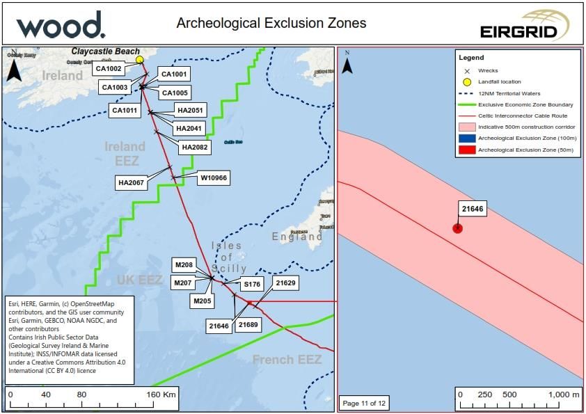
Celtic Interconnector                                                                 EIAR
                                                              Written Scheme of Investigation

Figure 1.2: Celtic Interconnector Submarine Cable Route Map

June 2021
                                                                                         8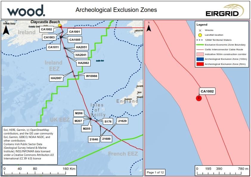
Celtic Interconnector                                                                        EIAR
                                                                     Written Scheme of Investigation

1.4       Geographical scope
This Outline WSI applies to the marine elements of the Celtic Interconnector within Irish TW
and EEZ and the UK EEZ, focusing on a corridor extending 500m to either side of the
proposed cable route centreline.
Mitigation works within the French EEZ and Terrestrial Waters, and within the Irish and
French terrestrial zones are provided for elsewhere and do not form part of the scope set out
in this Outline WSI.

June 2021
                                                                                                9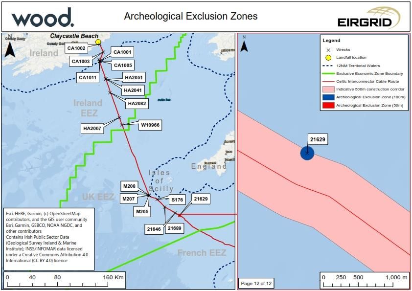
Celtic Interconnector                                                                             EIAR
                                                                          Written Scheme of Investigation

2     Aims and Objectives

2.1       Aim
The overarching aim of the WSI is to set out the scope and standards for the archaeological
mitigation referenced in the EIAR / ER (Volume 3D Part 1 Chapter 11 Historic
Environment and Volume 4 Chapter 11 Historic Environment).
2.2       Objectives
The objectives of this Outline WSI are as follows:
          •    To provide for archaeological investigation of areas of potential or confirmed
               archaeological interest that may be affected by the proposed development;
          •    To provide for archaeological analysis and interpretation of geophysical survey
               work carried out in advance of any construction or clearance operations;
          •    To identify the position and extent of Archaeological Exclusion Zones (AEZs)
               intended to protect known and potential areas of archaeological interest;
          •    To provide for avoidance of or mitigation of damage to archaeological remains
               identified during surveys and the construction period; and
          •    To set out reporting and licencing requirements for survey, mitigation and
               observations of archaeological material.

June 2021
                                                                                                    10
Celtic Interconnector EIAR
Written Scheme of Investigation
3 Roles and Responsibilities
3.1 Project roles and responsibilities are defined as set out at Table 3.1.
Table 3.1: Project Roles and Responsibilities
Roles Responsibilities
Developer • Ensure that WSI is implemented and that any relevant
statutory or regulatory requirements and processes are met;
• Procure appropriate archaeological support;
• Ensuring that any necessary licences or permissions are in
place before work commences;
• Provide relevant project information as appropriate; and
Identify Nominated Contacts for the Protocol for Archaeological
Discoveries.
Retained Marine • Advise the Developer on interaction with
Archaeologist* consultees/regulators and specialist contractors;
• Monitor the implementation of the agreed WSI, in particular,
where delivery of the WSI is divided into discrete lots or where
specialist contractors subcontract aspects of the WSI, ensuring that
all aspects of the WSI are in scope;
• Confirm to the client that any licences required for
archaeological works are in place, and that archaeological works
required out as a condition of other licences/consents are in place;
• Advise on the reporting of findings in line with the PAD;
• Monitor compliance with any established AEZs;
• Ensuring that any statutory or regulatory requirements are
appropriately considered and allowed for in archaeological works;
• Where necessary, coordinate reporting of results of
investigation or archaeological discoveries so that findings in the
UK EEZ which inform understanding of findings in Irish Waters and
vice versa are appropriately considered; and
• SQEP – The Retained Marine Archaeologist of works must
have an appropriate level of qualification and experience in
managing and monitoring Marine Archaeological and
Geoarchaeological workscopes.
Specialist Contractors • Implement all relevant aspects of the WSI covered by the
(and Sub-Contractors) appointed scope of works;
• Produce method statements for the appointed workscope
for approval by the relevant regulators;
• Securing and holding any relevant excavation, diving or
survey licences for archaeological work;
June 2021
11Celtic Interconnector EIAR
Written Scheme of Investigation
Roles Responsibilities
• Ensure that all project staff and subcontractors understand
the requirements of the WSI;
• Obey all relevant statutory and policy requirements;
• Respect constraint maps and AEZs;
• Inform the appointed archaeologist(s) of any environmental
constraint or matter relating to health, safety and welfare of which
they are aware that is relevant to the archaeologists’ activities; and
• SQEP – All archaeological contractors should have an
appropriate level of experience for their project role and
archaeological scope, and where works are carried out in Irish
Territorial Waters and EEZ must be eligible to hold the necessary
licence for excavation or survey.
*The Retained Marine Archaeologist would normally be independent of any appointed
contractors, but this role may be filled by an organisation also appointed as a specialist
contractor if required.
3.2 Liaison with Regulators
Key Regulators are identified as follows:
• Cork County Heritage Officer (From MHWS to LAT at Claycastle);
• Underwater Archaeology Unit (From MHWS at Claycastle to the UK/Irish
Median); and
• Historic England (From the Irish/UK Median to the UK/French Median).
Additional Stakeholders include those providing archaeological support within the Irish
Terrestrial Zone and the French EEZ. Communication with these stakeholders will be
required, as appropriate, to ensure that applicable findings from these areas can be fed into
planning, implementation, and reporting of the works set out in this WSI.
The Retained Marine Archaeologist will establish and maintain a register of stakeholders
including client and construction contractors, archaeological contractors, regulators, and
other relevant interested parties, including telephone and email contact details for key
individuals.
During the Project, communication with the regulators will be undertaken via the Retained
Marine Archaeologist in line with a reporting schedule to be agreed with relevant
stakeholders. This reporting schedule should consider the need for milestone-based
reporting and periodic reporting. Key project milestones may include, but not necessarily be
limited to:
• Approval of contractor method statements and licence applications;
• Notification of commencement of works;
• Periodic reporting during works;
June 2021
12Celtic Interconnector EIAR
Written Scheme of Investigation
• Notification of features identified in surveys;
• Notifications of discoveries through the PAD;
• Notification of completion of fieldwork;
• Periodic updates during post-excavation reporting; and
• Submission of post-excavation reporting.
Method Statements, and any applicable licence applications, for archaeological works will be
submitted to the relevant Regulator(s) and Archaeological Curator(s) sufficiently in advance
of the planned commencement of works to allow for sufficient time for the review and any
amendments to be completed and agreed.
June 2021
13Celtic Interconnector EIAR
Written Scheme of Investigation
4 Baseline Summary
4.1 Previous archaeological work
Previous archaeological work is summarised at Table 4.1.
Table 4.1: Desk based studies
Study Scope and Key Findings
Ireland-France Celtic Marine Archaeology baseline study aiming to:
Interconnector, Marine • Assess the nature of the cultural resource in this area;
archaeology desk-based • To outline the archaeological potential of the marine
assessment. (Headland environment;
Archaeology 2014) • To aid in the identification of seabed anomalies that may be
discovered during the proposed; geophysical survey; and
• Inform and propose mitigation for sites that may be
impacted by the proposed geotechnical survey.
Results:
• Identification of recorded potential wrecks and obstructions;
and
• Identification of potential for survival of deposits of
geoarchaeological interest within the intertidal and marine zones.
Ireland-France Celtic Review of geophysical (side scan, seismic (pinger) and
Interconnector: magnetometer) and bathymetric (MBES) data, in order to identify
Archaeological Review of sites or features of archaeological potential, and to characterise the
Geophysical Survey Data marine environment in terms of prehistoric landscape potential and
(Headland Archaeology significance.
2015) Identified three medium potential anomalies and 40 low potential
anomalies in proximity of the Cable Survey Corridor (CSC).
Celtic Interconnector – Geoarchaeological assessment of vibrocore logs from Irish TW and
Feasibility Study, Stage 1 EEZ. Identified locations where deposits of geoarchaeological
Geoarchaeological interest survive.
Assessment of Vibrocore
Logs.
(Wessex Archaeology
2016)
Celtic Interconnector Marine archaeology baseline survey of the revised offshore routes
Project Marine archaeology related to the Ballinwinning, Claycastle and Redbarns landfalls.
desk-based assessment Identified one potential wreck within the Cable Study Corridor
(Cotswold Archaeology (CSC) and areas of geoarchaeological interest.
2017)
June 2021
14Celtic Interconnector EIAR
Written Scheme of Investigation
Study Scope and Key Findings
Celtic Interconnector Assessment of the potential effects of proposed ground
Project Marine investigation works at Ballinwinning, Redbarn and Claycastle and
archaeological impact within Irish TW.
assessment for proposed
ground investigation
surveys. (Cotswold
Archaeology 2018)
Archaeological review of Walkover and geophysical surveys of potential landfalls at
foreshore walkover, and Claycastle and Redbarns and associated cable routes, with a
foreshore and offshore further walkover survey at a potential landfall at Ballinwinning.
geophysical survey data. Identified potential archaeological features within the foreshore at
(Cotswold Archaeology Claycastle and Redbarns and potential features of
2018) geoarchaeological interest and one potential wreck within the
marine zone.
Archaeological monitoring Archaeological monitoring of ground investigation at Claycastle,
as part of the Ballinwinning and Ballycroneen. No archaeological remains were
Celtic Interconnector observed at Ballinwinning or Ballycroneen, but buried peats were
Project, observed at Claycastle.
Claycastle & Summerfield/
Clonard East/ Ballycrenane,
County Cork. (IAC
Archaeology 2018)
Celtic Interconnector Consolidates previous reporting, focusing on the final agreed route.
Project, Marine Sets out archaeological baseline for the entire route between Irish
Archaeology and Cultural and French landfalls, identifying areas of geoarchaeological and
Heritage Report. (Cotswold archaeological interest.
Archaeology 2019)
Celtic Interconnector Assessment of samples recovered from Claycastle and Redbarns
Project beaches identified estuarine deposits and a potential submerged
Geoarchaeological forest in near shore and intertidal areas of Claycastle Beach.
Assessment. (Cotswold
Archaeology 2019)
Celtic Interconnector Report on augering and test pitting at Claycastle beach. Identified
Project buried peats within the proposed cable route.
Claycastle Beach, Youghal,
Co. Cork, Ireland
Geoarchaeological
assessment of auger and
test pit logs. (Cotswold
Archaeology 2019)
June 2021
15Celtic Interconnector EIAR
Written Scheme of Investigation
4.2 Marine Archaeological remains
The estuary of the River Blackwater forms a natural harbour at Youghal, which is recorded
as having been formed by exceptional tidal conditions in the early 9th century AD, and which
has been in use throughout the historic period. The approach to the harbour appears to be
marked by a concentration of recorded losses and obstructions, and while the cable route
passes to the south and west of the principal concentration of recorded wrecks, desk-based
assessment has noted the presence of a number of recorded and potential wreck sites. The
proposed cable route passes through an area to the south-west of the principal routes into
and out of the harbour. As the route moves further into the Celtic Sea, it enters an area
historically used for access to the Atlantic ports of Ireland, England, Wales, and France and
for access to the English Channel, and while recorded and potential wrecks and obstructions
become more sparsely distributed, the potential that such features may be affected will
remain.
There are no formally designated wrecks within the CSC or wider study area. Previously
recorded losses and geophysical anomalies assessed as of medium archaeological potential
(no high potential anomalies that cannot be correlated to recorded losses have been noted
within the CSC or wider study area) in Irish Territorial Waters and EEZ are summarised at
Table 4.2 and within the UK EEZ are summarised at Table 4.3.
Irish TW and EEZ
Table 4.2: Recorded losses, obstructions and geophysical anomalies suggestive of
potential wrecks within the CSC
ID Name Classification Place of Date of Lat Long Source
Loss Loss
W10966 Unknown Unknown Unknown 50.74167 -
Unknown 7.35833 UKHO
W11319 Unknown Celtic Unknown 51.6625 - UKHO
Sea 7.82817 Eoghan
Unknown Kieron
HA2041 Unknown Medium Unknown Unknown 51.40426 - Headland
potential 7.69868 Archaeology
magnetic and 2015
sidescan
anomaly
HA2051 Unknown Unknown Unknown 51.4032 - Headland
Medium 7.70485 Archaeology
potential 2015 (also
magnetic and recorded by
bathymetric Osiris as
anomaly M61)
June 2021
16Celtic Interconnector EIAR
Written Scheme of Investigation
ID Name Classification Place of Date of Lat Long Source
Loss Loss
HA2052 Unknown Medium Unknown Unknown 51.40356 - Headland
potential 7.70513 Archaeology
sidescan 2015
anomaly
HA2067 Unknown Medium Unknown Unknown 50.85182 - Headland
potential 7.40951 Archaeology
sidescan 2015
anomaly
HA2082 Unknown Medium Unknown Unknown 51.21056 - Headland
potential 7.61294 Archaeology
sidescan 2015
anomaly
HA5000 Unknown Unknown Unknown 51.68806 - Headland
7.84895 Archaeology
Medium 2015 (also
potential recorded by
magnetic Osiris as
anomaly M37)
UK EEZ
Table 4.3: Recorded losses, obstructions and geophysical anomalies suggestive of
potential wrecks within the CSC
ID Name Category Lat Long Comments
21629 Gadsby Non-dangerous 49.4256667 6.1348333 Recorded as dead
wreck wreck of British
merchant vessel sunk
by the submarine U-39,
33 miles SSW of Wolf
Rock. There were no
casualties.
21689 Foul ground 49.5481347 6.4544994 Identified as fisherman’s
fastener first recorded
1977
21646 Foul ground 49.4609236 6.2253535 Identified as fisherman’s
fastener first recorded
1977
Easting Northing
S176 Sonar anomaly 672053.90 5503708.40 Possible wreckage
identified in sidescan
June 2021
17Celtic Interconnector EIAR
Written Scheme of Investigation
ID Name Category Lat Long Comments
sonar survey; measures
7.7m x 4.2m x 1.9m.
Appears close to
reported wreck 21754
(wreck of British
merchant vessel sunk
by submarine U-29, 10
miles south of St Mary's,
Scilly) and may be
related.
M205 Magnetic anomaly 659168.20 5510438.70 Part of a cluster of
anomalies possibly
representing minor
wreckage
M206 Magnetic anomaly 659201.90 5510363.20 Part of a cluster of
anomalies possibly
representing minor
wreckage
M207 Magnetic anomaly 659242.20 5510264.90 Part of a cluster of
anomalies possibly
representing minor
wreckage
M208 Magnetic anomaly 659263.20 5510217.20 Part of a cluster of
anomalies possibly
representing minor
wreckage
No previously identified marine archaeological remains would be affected by the
proposed scheme, and it is considered unlikely that marine archaeological remains
would be affected by the proposed scheme.
June 2021
18Celtic Interconnector EIAR
Written Scheme of Investigation
5 Proposed Mitigation
5.1 Introduction
In-principle, mitigation measures for the Proposed Development have been set out in
Volume 3D1, Chapter 11 and Volume 4, Chapter 11 of the EIAR / ER. This mitigation
comprises a combination of avoidance measures and archaeological investigation in
addition to a Protocol for Archaeological Discoveries.
In advance of any archaeological survey or mitigation, the archaeological contractor(s) will
produce either an application for the appropriate licence (Irish TW and EEZ) or detailed
method statements (UK EEZ) for the archaeological works identified. These Licence
applications and/or Methods Statements will detail:
• The scope of the relevant works;
• Relationship to survey and construction programme and survey timetable;
• Archaeological aims and objectives of works;
• Investigation methodology including sampling and finds policies and
arrangements for immediate conservation, storage and processing of
archaeological material;
• Provisions and timetable for post-investigation processing, assessment and
analysis of archaeological material;
• Reporting;
• Provision for reasonable monitoring by local and national regulators; and
• Health, safety, and welfare.
Licence Applications and/or Method statements will be agreed with the Retained Marine
Archaeologist in advance of submission to the relevant regulators in sufficient time to allow
for regulatory comments and any required revisions to be actioned in advance of the start of
works, having regard to response times set out by regulators.
5.2 Marine Archaeological Remains
Review of Marine Geophysical Surveys
Marine geophysical surveys have been undertaken along the entire cable route, with
specialist archaeological interpretation carried out of the results of survey within Irish TW
and EEZ. Further geophysical surveys are likely to be undertaken as part of the detailed
design of the proposed cable route.
Existing geophysical survey data for the UK EEZ and any newly acquired survey data should
be reassessed in line with English Heritage (2013) Marine Geophysics Data Acquisition,
Processing and Interpretation to ensure that potential archaeological remains can be better
characterised and that the AEZ identified at Section 5.5 of this Outline WSI are appropriate.
June 2021
19Celtic Interconnector EIAR
Written Scheme of Investigation
This process may result in the identification of new AEZ or the modification of existing AEZ.
Any modifications to the stated AEZ will be agreed with the relevant national regulator.
The scope and methods of any proposed marine geophysical survey carried out for non-
archaeological purposes (e.g.: UXO survey or engineering) will discussed with the Retained
Marine Archaeologist to ensure that the requirement to gather archaeological information is
appropriately considered. Advice will consider:
• available details of sites and / or anomalies identified in previous desk-based and
geophysical survey;
• archaeological potential of areas where no existing sites and/ or anomalies are
yet known;
• types of survey and specifications and settings of geophysical equipment to be
used;
• survey specifications, including spacing and orientation of lines and cross lines;
• any potential requirement for an on-board archaeological geophysicist during
survey; and
• requirements for post-processing, interpreting, and archiving resulting data.
Where further surveys are required to confirm the results of geophysical survey for
archaeological purposes (usually only in areas of archaeological interest where impact
cannot be avoided), the scope and methods of survey would be agreed with the relevant
national regulator.
The results of further geophysical interpretation will be reported in line with requirements for
report set out at Section 7 of this Outline WSI.
Archaeological assessment of ROV survey data
The scope and methods of any proposed ROV video/drop down camera survey carried out
to investigate obstructions identified in geophysical survey or during the course of
clearance/construction activities will be discussed with the Retained Marine Archaeologist to
ensure that the requirement to gather archaeological information is appropriately considered.
Advice will consider:
• potential requirements for survey licencing by the National Monuments Service;
• details of AEZ and/or geophysical anomalies within the development area;
• types of survey and specifications and settings of imaging equipment to be used;
• the provision of guidance on the types of sites and finds that are anticipated and
which would require investigation, and the level of recording required;
• any requirements for review of data recovered from the survey; and
• the potential requirement for an on-board archaeological geophysicist to advise
on image capture during survey.
June 2021
20Celtic Interconnector EIAR
Written Scheme of Investigation
An archaeological method statement would be prepared for any such survey, including
archaeological objectives and requirements, and setting out any specific technical
requirements to allow for meaningful archaeological results. In Irish waters, this method
statement would be a requirement of the licencing process where licencing is required.
Reporting of the archaeological assessment will be required in a timely fashion to support
any decision-making on further actions. The format and timetable for reporting shall be set
out in any methods statement, to reflect the scope of survey and the equipment used.
The results of these surveys will be used to confirm or modify existing or establish new AEZ,
in consultation with the relevant national regulator.
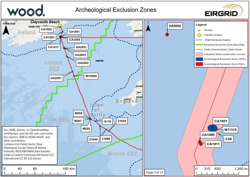
5.3 Archaeological Exclusion Zones
AEZ have been established in respect of all observed geophysical anomalies of
demonstrable or suspected anthropogenic origin within the cable survey corridor and are
shown at Appendix B. The standard practice in this case is to identify a 100m AEZ around
known wrecks or high potential geophysical anomalies, and a 50m exclusion zone around
other obstructions or wreckage. These AEZs are defined to encompass the full observed
extent of any archaeological remains and a buffer to ensure that these remains will not be
affected by the proposed works.
Further AEZs will be defined where anomalies or observations of archaeological material not
previously identified are made during the pre-construction surveys or during construction
work. The scale and location of such further AEZs will be confirmed with the relevant
national regulator.
Further survey work may suggest that established AEZs are not appropriate, either due to
anomalies being identified as having non-archaeological origins, or more accurate locations
and extent of archaeological material being identified. In these cases, amendments to the
established AEZ will be agreed with the relevant national regulator.
Construction work would not normally take place within a defined AEZ, and it is anticipated
that any detailed design would have regard to established AEZ. Where works within an AEZ
cannot be avoided, further investigation will be required in line with provisions for
archaeological review of geophysical and ROV survey as set out at Section 5.4.
Table 5.1 Proposed AEZ within the CSC (Irish TW and EEZ: See also Appendix B
maps 1-7)
ID Name Classification Lat Long AEZ
W10966 Unknown Unknown; identified as 50.74167 -7.35833 100m
demasted brig of
unknown date (Cotswold
Archaeology 2019)
W11319 Unknown Unknown 51.6625 -7.82817 n/a
June 2021
21Celtic Interconnector EIAR
Written Scheme of Investigation
ID Name Classification Lat Long AEZ
HA2041 Unknown Medium potential 51.40426 -7.69868 50m
magnetic and sidescan
anomaly
HA2051 Unknown Medium potential 51.4032 -7.70485 50m
magnetic and
bathymetric anomaly
HA2052 Unknown Medium potential 51.40356 -7.70513 50m
sidescan anomaly
HA2067 Unknown Medium potential 50.85182 -7.40951 50m
sidescan anomaly
HA2082 Unknown Medium potential 51.21056 -7.61294 50m
sidescan anomaly
HA5000 Unknown Medium potential 51.68806 -7.84895 50m
magnetic anomaly
CA8 Unknown – Unknown 51.66145 n/a
same as
W11319
Easting Northing
CA1001 Unknown – High potential 580911 5724197 100m
confirmed bathymetric and
location of magnetic anomaly.
CA8/W11319 Probable wreck site
measuring 91.4m long by
7.3m high
CA1002 Unknown Medium potential 580878 5750872 50m
magnetic anomaly –
probable metallic debris
CA1003 Unknown Medium potential – 586418 5738751 50m
magnetic anomaly and
small rounded reflector
CA1005 Unknown Medium potential 580536 5723787 50m
anomaly. Bathymetric
high close to two
magnetic anomalies
CA1011 Unknown Medium potential 580567 5723726 50m
magnetic anomaly with
associated small reflector
probable metallic debris
June 2021
22Celtic Interconnector EIAR
Written Scheme of Investigation
Table 5.2 Proposed AEZ within the CSC (UK EEZ: See also Appendix B maps 8-12)
ID Name Category Lat Long AEZ
21629 Gadsby Non-dangerous wreck 49.4256667 6.1348333 100m
21689 Foul ground 49.5481347 6.4544994 50m
21646 Foul ground 49.4609236 6.2253535 50m
Easting Northing
S176 Sonar anomaly 672053.90 5503708.40 50m
M205 Magnetic anomaly 659168.20 5510438.70 50m
M206 Magnetic anomaly 659201.90 5510363.20 50m
M207 Magnetic anomaly 659242.20 5510264.90 50m
M208 Magnetic anomaly 659263.20 5510217.20 50m
It is not anticipated that any disturbance would arise to the remains identified above where
the works respect the defined AEZ.
5.4 Protocol for Archaeological Discoveries
General
While it is not anticipated that previously unknown sites or material would be observed
during the construction of the proposed development, measures are required to mitigate any
impact on archaeological remains and to ensure that relevant statutory responsibilities are
met. The scope of ‘archaeological remains’ includes any submerged prehistoric material,
human remains, shipwreck material or aviation material, and material which either falls
within the definitions set out in the statutes above or could reasonably be considered to fall
within these categories.
Archaeological material does not include modern material with limited informative, cultural or
historic value, such as chance loss of cargo or fishing gear, and the Protocol for
Archaeological Discoveries (PAD) does not supplant any other requirements to report
wreckage, salvage or other loss under other statutory provisions (i.e. those covering
environment, safety, navigation, and wreck, salvage or other property rights), and advice on
these issues should be taken from appropriately qualified specialists.
The PAD sets out a protocol for action where archaeological remains are observed during
survey or construction out with an agreed scheme of archaeological works.
Where unexpected archaeological remains are observed during the conduct of an
established archaeological investigation, the responsibility for reporting to the client will be
with the appointed specialist archaeological contractor in line with any agreed method
statements.
This PAD supplements, and does not supersede, any requirements to report marine
wreckage for navigational, wreck or other statutory/guidance/best practice purposes.
June 2021
23Celtic Interconnector EIAR
Written Scheme of Investigation
This PAD provides for a four-step process:
1 Reporting of potential archaeological material to the Retained Marine Archaeologist;
2 Provision of archaeological advice and, where required definition of temporary exclusion
zones (TEZ) and archaeological investigation of identified features/material;
3 Where appropriate, establishment of new or revision of existing AEZs; and
4 Reporting of findings.
All relevant project staff show be briefed on the need for and operation of the PAD to ensure
that they are aware of the PAD, can recognise finds of archaeological potential, and
understand their responsibilities in respect of this material. Where appropriate, a copy of the
PAD should be appended to any written work instructions for reference during works. This
applies to any project staff involved in survey or intrusive clearance and construction works,
primarily:
• UXO survey(s);
• Prelay grapnel runs, and other clearance works;
• Cable ploughing; and
• Other works with potential for the discovery of material on the seabed and/or
recovery of material to the surface.
Reporting potential archaeological material to the Retained Marine Archaeologist
Any observation of archaeological material or material which appears to be of archaeological
origin is to be reported to the Retained Marine Archaeologist at the earliest opportunity.
In general, archaeological material should not be handled or deliberately recovered from the
seabed without seeking advice from the Retained Marine Archaeologist, but where
archaeological material is inadvertently recovered during operations, site staff should:
• Record the location at which the material was found;
• Handle material with care and no more than is necessary to allow for its safe
storage;
• Not attempt to clean material or remove encrustations;
• Take photographs and/or video to inform Retained Marine Archaeologist advice;
• Store material in a safe place where it will not be inadvertently lost or broken; and
• Seek advice from the Retained Marine Archaeologist.
Finds of ordnance or other dangerous or controlled materials are to be treated within
established protocols for those materials in precedence to any archaeological recording, and
while these materials should be reported to the Retained Marine Archaeologist, the
provisions of the PAD shall not apply unless these materials have been rendered safe or
safe systems of work have been established.
June 2021
24Celtic Interconnector EIAR
Written Scheme of Investigation
Material should be stored in a condition as close as possible to the conditions from which it
was recovered. Waterlogged material should be kept damp and in a dark place where
possible.
Where potential archaeological remains are identified in advance of intrusive construction
work (e.g., geophysical survey or drop-down video) the location and nature of the anomaly
should be reported to the Retained Marine Archaeologist so that an appropriate TEZ can be
established, and the observation recorded for archaeological purposes. The works should,
where reasonably practicable, considering the nature and importance of the find and the
nature of the works, deviate round the identified anomaly.
Where potential remains are identified during or after site clearance or intrusive construction
work, deviation of the route is unlikely to represent an appropriate mitigation, and the
location at which potential archaeological remains were observed should be reported. Where
possible, any remains should be recovered to the vessel so that the nature of the remains
can be determined, and work should cease or move to an alternate location while further
advice is sought from the Retained Marine Archaeologist.
Provision of archaeological advice
The Retained Marine Archaeologist will arrange for appropriate identification of any material
recovered, and, where appropriate, will advise on any temporary restrictions to operations
within the vicinity of the find, and the establishment of any TEZ that may be necessary to
allow for protection of archaeological remains, pending consultation with the appropriate
national regulators.
Where further construction or other intrusive works are required within the vicinity of
archaeological material, further investigative survey may be required to fully understand the
nature and extent of archaeological remains. The Retained Marine Archaeologist will advise
on the scope of such survey and will agree proposals for survey with the relevant national
regulator.
The Retained Marine Archaeologist will advise the client on reporting requirements for
archaeological purposes, and on potential requirements for route deviation, amendments to
working practices or support to further investigation, recording, moving, storage and/or
analysis of archaeological material, and will inform the relevant national regulators, agreeing
any further actions with the client and relevant national regulator.
Where heritage-based licensing is required for further survey, investigation or recovery and
analysis of archaeological material, any such licence will be obtained by the relevant
specialist contractor undertaking the proposed work.
Revision or establishment of AEZ
Where archaeological remains are identified and mitigation cannot be achieved by either
recovery and recording or movement of these remains or, in the case of remains identified in
advance of construction works, the Retained Marine Archaeologist will agree the location
and scale of any required AEZ with the relevant national regulators. While this would
June 2021
25Celtic Interconnector EIAR
Written Scheme of Investigation
normally require the extension of existing or establishment of new AEZ, it may be
appropriate to move, amend or remove existing AEZ where survey identifies that these have
not been appropriately defined.
Reporting of findings
Further to initial reporting of findings to the appropriate national regulator by the Retained
Marine Archaeologist, any reporting of identification and analysis of archaeological material
will be carried out in line with the general provisions for reporting set out at Section 7 of this
Outline WSI, except where superseded by requirements of any formal licence required for
those works.
June 2021
26Celtic Interconnector EIAR
Written Scheme of Investigation
6 Procedures in respect of statutorily protected remains
6.1 General
Any reporting of archaeological material observed during the proposed works shall be made
by the Retained Marine Archaeologist, except where reporting is required as a condition of
specific archaeological licencing, in which case the named person/organisation in that
licencing shall carry out any reporting, ensuring that the Retained Marine Archaeologist is
informed.
All artefacts identified from material recovered will be retained, processed, and recorded in
accordance with the CIfA Standard and guidance for the collection, documentation,
conservation, and research of archaeological material (CIfA 2014) and/or the IAI Code of
Conduct for the Treatment of Archaeological Objects in the context of an archaeological
excavation (IAI 2006).
The initial processing and storage of soil samples and other ecofactual material will be
carried out in accordance with Environmental Archaeology: a guide to the theory and
practice of methods, from sampling and recovery to post-excavation (English Heritage,
2011) and Geoarchaeology: using earth sciences to understand the archaeological record
(Historic England, 2015) and/or Environmental Sampling: Guidelines for Archaeologists (IAI
2007).
The Methods Statements for each stage of work will identify appropriate named specialists
or, where required, licence holders, and will set out:
• Procedures for conservation assessment;
• Procedures for temporary storage, processing and recording of archaeological
material;
• A retention and discard policy; and
• Procedures for selection of material for further assessment and analysis.
It is not anticipated that human remains will be present within the CSC, given the prevailing
conditions, which are not favourable for the preservation of human remains, and the
absence of evidence for wrecks within the working areas. However, in that excavation of
human remains is closely governed by statute in both the UK and Ireland, provision must be
made in any methods statements for intrusive archaeological works for actions to be taken in
the event of human remains being observed or recovered.
6.2 Archaeological Material
Irish TW and EEZ
The National Monuments Amendment Act 1994 sets out that all archaeological objects are
the property of the Irish State. As such, procedures for reporting discoveries of
archaeological material, its recovery, analysis and storage are required as part of the
June 2021
27Celtic Interconnector EIAR
Written Scheme of Investigation
process of licencing archaeological investigations, and procedures in respect of
archaeological material recovered in Irish TW or EEZ will be set out in the detailed methods
statements required by this Outline WSI.
UK EEZ
Archaeological artefacts that have come from a ship are considered to be ‘wreck’ for the
purposes of the Merchant Shipping Act 1995, and the Receiver of Wreck must be notified
within 28 days of recovery.
Arrangements for agreeing reasonable access for study of archaeological material and/or
transfer of title of that material to an appropriate receiving museum must be agreed with the
lawful owner and/or the Receiver of Wrecks. This is particularly important where analysis of
material could be destructive, and such analysis must not take place without appropriate
lawful authority.
Any items which are recovered which could be deemed as Treasure1 will be subject to the
provisions of the Treasure Act 1996 . Such material shall normally be removed from site to a
secure location as soon as is reasonably practicable and is compatible with appropriate
archaeological investigation and recording.
In addition to the statutory authorities the Marine Antiquities Scheme should be informed.
6.3 Human remains
General
The Archaeological Contractor will have available within the team or on call an appropriately
qualified and experienced osteo-archaeologist to assist the recovery, storage and
processing of any human remains.
Irish Territorial Waters and EEZ
It is a legal obligation under the Coroner’s Act 1962 and the National Monument Acts to
notify the Garda Siochana and the National Museum of Ireland where human remains are
unexpectedly or accidentally identified. Where it is established that the remains are not
recent, they are considered to be archaeological artefacts under the National Monuments
(Amendment) Act 1994, which sets out the legal definition of an archaeological object to
include ‘ancient human remains.
1Treasure is as defined by the Treasure Act 1996 and the Treasure (Designation) Order 2002. In
brief, Treasure comprises any metal object, other than a coin, of at least 10 per cent by weight of gold
or silver at least 300 years old. A prehistoric object is Treasure where any part of it is precious metal,
or where two or more metallic objects come from the same find.
Two or more coins from the same find are Treasure provided they are at least 300 years old and
contain 10 per cent gold or silver (more than ten coins containing less than 10 per cent of gold or
silver are Treasure). Objects found with Treasure would also comprise Treasure. As finds may have
become scattered since they were originally deposited, an object would be part of the 'same find' as
another object or coin if it is found in the same place as, or had previously been together with, the
other object.
June 2021
28Celtic Interconnector EIAR
Written Scheme of Investigation
Until such time as the National Museum of Ireland makes a decision on the future retention
and care of human remains, the licensed site director has responsibility for their excavation,
post excavation care and analysis, and any further works must be carried out under the
terms of an excavation licence.
Where appropriate, any Method Statements produced in line with the Outline WSI above will
set out clear and specific proposals for the appropriate reporting, recording, excavation,
analysis, and storage of human remains.
UK EEZ
In the event of human remains being encountered, the Retained Marine Archaeologist will
be informed to allow formal reporting to the national regulator as appropriate. Where
appropriate, the Archaeological Contractor will arrange receipt of any necessary licencing to
enable the legal removal of any human remains encountered in the works.
Military Remains
The 1986 Protection of Military Remains Act (PMRA) applies to any aircraft which have
crashed while in military service and to certain wrecks of vessels which were wrecked while
in military service within UK waters. PMRA makes it an offence to disturb, move or unearth
military remains which have been designated.
There are no designated protected areas or controlled sites within the CSC, and there are
no records of military vessels or aircraft having been lost within the Order limits.
Where remains of military aircraft are observed during archaeological investigation or
construction work, intrusive work should cease, and the site be secured while consultation
with the Ministry of Defence is undertaken.
It should be noted that the PMRA also applies to aircraft or vessels lost in British military
service throughout the world, and the procedures set out below may also apply to where
such remains are present out with the UK EEZ.
Where remains of military vessels or aircraft lost in service of nations other than the UK or
Ireland are identified, due regard should be given to any requirement to report such
discoveries to the relevant national regulator of the nation in the service of which the vessel
or aircraft was lost.
.
June 2021
29Celtic Interconnector EIAR
Written Scheme of Investigation
7 Post-Excavation and Reporting
7.1 General
Proposals for reporting of each phase of archaeological work will be set out in the relevant
detailed methods statements. These will set out:
• Reporting timetable;
• Reporting process and any requirement for periodic, interim or assessment
reporting;
• Provisions for publication or wider dissemination; and
• Archival of physical, paper and/or digital material.
7.2 Reporting of pre-construction surveys
The results of any pre-construction surveys will be necessary to inform project planning and
the detail of mitigation requirements and to support consultation with the relevant national
regulators. It is therefore important that they are reported in a sufficiently timely manner to
inform these purposes. The detailed method statements for these phases of work will set out
an agreed timescale for reporting, considering the potential for abbreviated interim or
headlines reporting where appropriate, to ensure that the value of the surveys can be
realised.
7.3 Post-Fieldwork Reporting
Post-fieldwork reporting may fulfil a number of purposes, and regard must be had to these in
setting out the detailed methods statements, which should consider the relevant
requirements at the completion of each stage of work.
All stages of post-fieldwork reporting may not be appropriate for all archaeological works,
and therefore, any licence applications or detailed methods statements will set out an
appropriate format and timetable for the presentation of reporting, having regard to the
works completed, the findings of those works and the need to provide an appropriate level of
descriptive text, catalogue data, site photography/images, survey data, and
maps/plans/charts at each stage.
Reporting stages would normally comprise:
• Fieldwork Completion Reporting:
o This type of reporting would normally take the form of a summary note,
representing a very brief summary sufficient to confirm the completion of
fieldwork; provide a scope and timetable for detailed reporting; and
signpost any significant findings to inform research and development
management pending the production of the full report.
• Assessment Reporting:
June 2021
30You can also read