Central Oregon Irrigation
District Patron Handbook
←
→
Page content transcription
If your browser does not render page correctly, please read the page content below
Central Oregon Irrigation District Patron Handbook

CENTRAL OREGON IRRIGATION DISTRICT
             A MUNICIPAL CORPORATION OF THE STATE OF OREGON

Welcome to the Central Oregon Irrigation District (COID). This handbook is
an educational tool to help you understand district policies and procedures
as well as helping you keep your water rights in good standing. Owning land
with water rights comes with many rules and responsibilities. Should you
have any questions please call the office or email us. The COID website is the
best place to keep up on current information about the district. Our office
hours are from 7am–4pm and we have an emergency answering service for
after-hours water issues. You can also email us with any questions you might
have. We look forward to serving you as a COID Patron.

Phone: 541-548-6047
Email: info@coid.org
Website: www.coid.org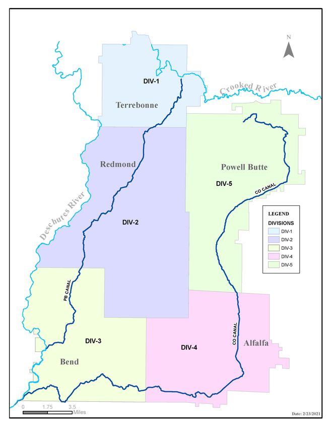
CONTENTS

District Overview. . . . . . . . . . . . . . . . . . . . . . . . . . . . . . . . . . . . . . . . . . . . . . . . . . . . . . . 4
Board of Directors. . . . . . . . . . . . . . . . . . . . . . . . . . . . . . . . . . . . . . . . . . . . . . . . . . . . . . 4
Division Map. . . . . . . . . . . . . . . . . . . . . . . . . . . . . . . . . . . . . . . . . . . . . . . . . . . . . . . . . . . 5
History. . . . . . . . . . . . . . . . . . . . . . . . . . . . . . . . . . . . . . . . . . . . . . . . . . . . . . . . . . . . . . . . 6
Assessments. . . . . . . . . . . . . . . . . . . . . . . . . . . . . . . . . . . . . . . . . . . . . . . . . . . . . . . . . . . 8
Fees. . . . . . . . . . . . . . . . . . . . . . . . . . . . . . . . . . . . . . . . . . . . . . . . . . . . . . . . . . . . . . . . . . . 8
Water Rights. . . . . . . . . . . . . . . . . . . . . . . . . . . . . . . . . . . . . . . . . . . . . . . . . . . . . . . . . . . 9
Water Rights Transfers and Change of Ownership. . . . . . . . . . . . . . . . . . . . . . . . . . 10
Beneficial Use. . . . . . . . . . . . . . . . . . . . . . . . . . . . . . . . . . . . . . . . . . . . . . . . . . . . . . . . . 10
Tail Water and Waste. . . . . . . . . . . . . . . . . . . . . . . . . . . . . . . . . . . . . . . . . . . . . . . . . . . 11
Irrigation Season . . . . . . . . . . . . . . . . . . . . . . . . . . . . . . . . . . . . . . . . . . . . . . . . . . . . . . 12
Maintenance. . . . . . . . . . . . . . . . . . . . . . . . . . . . . . . . . . . . . . . . . . . . . . . . . . . . . . . . . . 13
Patroleman . . . . . . . . . . . . . . . . . . . . . . . . . . . . . . . . . . . . . . . . . . . . . . . . . . . . . . . . . . . 14
Beats Map . . . . . . . . . . . . . . . . . . . . . . . . . . . . . . . . . . . . . . . . . . . . . . . . . . . . . . . . . . . . 15
Winter Stock Water Runs . . . . . . . . . . . . . . . . . . . . . . . . . . . . . . . . . . . . . . . . . . . . . . . 16
Domestic Use of Water . . . . . . . . . . . . . . . . . . . . . . . . . . . . . . . . . . . . . . . . . . . . . . . . . 17
Rotation Schedules. . . . . . . . . . . . . . . . . . . . . . . . . . . . . . . . . . . . . . . . . . . . . . . . . . . . . 17
Mapping Department . . . . . . . . . . . . . . . . . . . . . . . . . . . . . . . . . . . . . . . . . . . . . . . . . . 18
District Rights-of-Way. . . . . . . . . . . . . . . . . . . . . . . . . . . . . . . . . . . . . . . . . . . . . . . . . . 18
Point of Delivery. . . . . . . . . . . . . . . . . . . . . . . . . . . . . . . . . . . . . . . . . . . . . . . . . . . . . . . 19
Land Use & Development. . . . . . . . . . . . . . . . . . . . . . . . . . . . . . . . . . . . . . . . . . . . . . . 20
Glossary. . . . . . . . . . . . . . . . . . . . . . . . . . . . . . . . . . . . . . . . . . . . . . . . . . . . . . . . . . . . . . 22
Conversion Charts. . . . . . . . . . . . . . . . . . . . . . . . . . . . . . . . . . . . . . . . . . . . . . . . . . . . . 23

                                                                                                                                         3
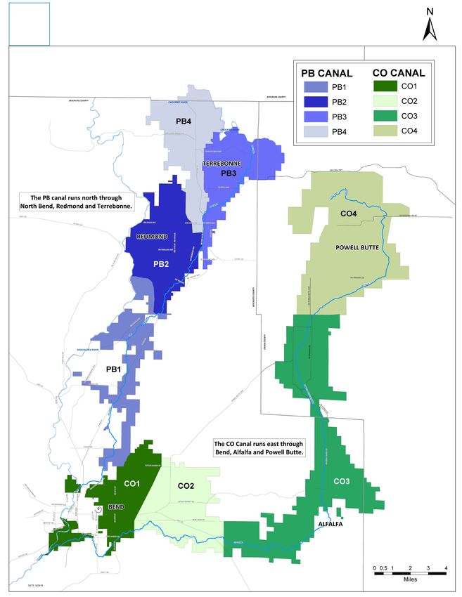
DISTRICT OVERVIEW
Central Oregon Irrigation District, incorporated in 1918, is a Quasi-Municipal
Corporation of the State of Oregon chartered under Oregon Revised Statute
Chapter 545. Most of COID’s authorities and responsibilities are presented in this
section of State law.

The irrigation system consists of two main canals: the Pilot Butte Canal, which
runs north through Bend, Redmond and Terrebonne; and the Central Oregon
Canal, which runs east through Bend, Alfalfa and Powell Butte. Both canals
divert water from the Deschutes River.

The District provides water for about 45,000 acres within an 180,000-acre area
in Central Oregon. More than 400 miles of canals provide agricultural and
industrial water to the Bend, Redmond, Terrebonne, Alfalfa and Powell Butte
areas. In addition, COID provides water to subdivisions in the areas the canals
pass through, for landscapes and lawns, parks, cemeteries and golf courses.

BOARD OF DIRECTORS
Central Oregon Irrigation District is divided into five divisions: Terrebonne,
Redmond, Bend, Alfalfa and Powell Butte. Each Division is represented by
an elected board member. Qualified water users elect these directors for a
term of three years. Qualified voters must be 18 years of age or older and
must own land situated within the District that is subject to the charges
or assessments of the District. However, the voter need not reside in the
District or in the State of Oregon.

The Board’s regular meetings are held on the second Tuesday of each
month at 9:00 a.m. in the District office and are always open to the public.
The annual meeting and the Board of Equalization are held on the first
Tuesday in January of each year. The Board represents the water users in
establishing rules, regulations and policies for an efficient and equitable
operation consistent with the law. The Board hires a general manager who
is responsible for carrying out the Board directives and the day-to-day
operation of the District.

4

COID is divided into 5 divisions.

                                    5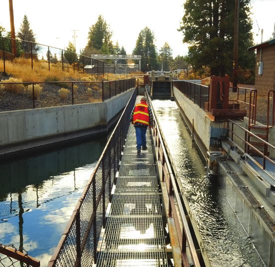
HISTORY
A.M. Drake initiated the first water diversion company, the Pilot Butte
Development Company, which also platted and mapped the cities of Bend and
Redmond. Prior to any water being delivered to a patron, the company was sold
to the Deschutes Irrigation & Power Company, the precursor of COID. 1904
marked the flow of irrigation water to the first 40 acres of land. By 1924, the
population had grown to 2,000 people with an impressive 28,500 acres under
irrigation. Irrigation helped create the cities of Bend and Redmond and helped
drive growth and industrialization to its present-day levels.

Before any water was diverted from the Deschutes River, appropriations to
divert the water had to be filed with the State of Oregon. The filing had to identify
where the diversion would occur and how much water would be diverted. Today
those very same appropriations are still in force. Water rights were assigned on a
first-come, first-serve basis also known as the “Doctrine of Prior Appropriations”.
But the ranch at the start of the canal must conserve and husband use if there
is to be any water for a ranch at the end of the canal. That same philosophy still
holds true today. Clean water is a resource to share and respect.

By 1907 the Central Oregon and the Pilot Butte Canals had been constructed.
1910 marked the creation of the Central Oregon Irrigation Company as a result
of foreclosure and ensuing reorganization of the Deschutes Irrigation & Power
Company. On December 17, 1917 the Central Oregon Irrigation Company was
turned over to its users who organized the Central Oregon Irrigation District.
The transition was not without rancor and was finally resolved by the courts
on July 9, 1921. The construction of canals and dams continued. 1912 saw the
completion of the North Canal Dam and connection to the Pilot Butte Canal.
It is located immediately south of The Riverhouse in Bend. The Central Oregon
Canal diversion is at the southern city limits of Bend.

The Carey Act of August 18, 1894 initiated many irrigation projects, such as
COID, by authorizing the federal government to contract with 17 western states
for land reclamation. The Carey Act structured the relationships between the
federal and state governments along with the irrigation projects that established
the water rights to reclaim the high desert land. A settler, referred to as an “Entry
Man”, signed a contract with an irrigation project to pay a certain amount for
water per acre of land desired to be reclaimed. The irrigation project used these
proceeds to construct the canals and laterals for the transport of water.

6
Once an Entry Man beneficially used the water to cultivate a crop and reclaim
t he desert land for three consecutive years, the Entry Man received title to
the land (usually 160 acres) from the State and the water right was perfected.
There were a number of successful and non-successful irrigation projects
attempted in Oregon. This led to numerous claims to water rights that were
eventually adjudicated in 1958.

Throughout this time various upgrades to the irrigation system were necessary.
Wooden flumes were replaced by steel pipes and mechanical cleaners were added
to intake screens. In 1938, COID, Crook County Improvement District #1
(Lone Pine) and the Arnold Irrigation District formed a cooperative effort with
the federal government to construct a dam at Crane Prairie.

In 1989, after nearly ten years of work, COID completed the Siphon Power
Project along the Deschutes River in southern Bend. This hydroelectric
power plant can produce 5.5 megawatts of electricity, which is being sold to
Pacific Power. This enables the District to further develop capital improvements
to “conserve water” and make the distribution system more efficient and
upgrade the canal system to benefit the water users. No new amounts of
water are available.

Surface water in Central Oregon is a finite resource. The only way additional
water will become available to COID’s subscribers is through conservation.

The District is very much the product and tool of its patrons. It provides
municipal, industrial and irrigation water to over 4,000 deliveries. Like any
municipal corporation, COID exists to serve its constituents and relies on
them for its well-being. COID is proud of its partnership in the development
of Central Oregon. We all look forward to continued involvement in our future
and, as a part of that, actively support the conservation of all our natural resources.

                                                                                      7
ASSESSMENTS
Assessments are in two basic parts and are set each January by the Board of
Directors. The assessment is not based on a quantity of water delivered, but on
the costs to operate and maintain the delivery system and the District.

    1. Base Charges: covers the cost of record-keeping, scheduling, insurance,
       office facilities, general administration and overhead.
    2. Operations and Maintenance: covers repairs and cleaning of the delivery
       system and the distribution of water.

The annual assessment is mailed out to each patron account in January.
Payment terms for assessments are as follows:

    1. First half of the yearly assessment is due and payable on April 1st.
       Interest will be charged, as prescribed by law, on the past-due portion as
       of May 1st.
    2. Second half of the yearly assessment is due and payable on July 1st.
       Interest will be charged, as prescribed by law, on the past-due portion as
       of July 1st.
    3. The District may withhold delivery of water on any past-due
       accounts.
    4. Accounts not paid in full by July 1st are considered delinquent and
       the following actions will be taken:
      • A $300.00 late fee will be assessed on all delinquent accounts.
      • The District will file a notice of claim of lien, which may lead
        to foreclosure.
Please contact the office to arrange a monthly payment plan if the above
terms present a challenge and to avoid any late fees. There will still be interest
charged on unpaid balances after May 1st. Credit and debit payments are
now accepted online with a 3% processing fee.

FEES
The District charges fees for such items as transfers, changes made to the canal
and road system, pumping of water from District canals for industrial use,
in-stream leases, crossings, etc. Any time a patron contemplates any of these
situations, they should contact our office.

8
WATER RIGHTS
A water right gives you permission and an obligation to beneficially irrigate
a very specific area (generally measured in acres). The District and the State
keep very detailed records of what lands can be irrigated. COID water rights
have priority dates of 1900 and 1907. In addition, there is a supplemental
right to a portion of the stored water from Crane Prairie Reservoir. Your
water right also has a “duty of water” which is the maximum volume of water
you can receive during the irrigation season. The duty is measured in “acre feet”
and is stipulated by Oregon court decree. The duty is not guaranteed and the
actual amount of water received during the irrigation season may vary from year
to year depending on snow pack and natural stream flow. This water can only be
applied to lands with a water right.

Your water right also has a “rate,” which is the amount of water that flows to your
land, measured in gallons per minute, during the irrigation season. The water
right stipulates this rate and varies during the irrigation season between four to
six gallons per minute per acre of water right. All COID water rights have the
same rate and duty.

To receive a higher duty or rate of water is a violation of the water right and can
lead to forfeiture.

A water right remains valid as long as an irrigator beneficially uses the water at
least one year out of every five years. Failure to beneficially use may force the
District to confiscate the water right or it will be forfeited to the State and lost
from the District. Converting land to another use (road, parking lot, building,
etc.) can also result in the forfeiture of a water right. Prior to converting land to
another use, please see the water transfer section.

If your land mass is five acres or more, you will be required to “map” the water
right “on” or “off ” of your property. If you are purchasing a water right, you will
also be required to have your land prepared to receive the water at the time the
transfer is processed. Oregon State law requires that lands with a new water right
be irrigated in the specific areas mapped within the first year of the transfer, and
at least one year out of every five years thereafter. If your water right is mapped,
you can only use the water on the specified areas.

                                                                                        9
WATER RIGHTS TRANSFERS AND
CHANGE OF OWNERSHIP
The District is required by law to keep detailed records of water rights and
landowners. If you wish to sell a water right, a portion of a water right, or
if you wish to purchase a water right, please contact the COID office. A
transfer requires an application to the State of Oregon’s Water Resource
Department (OWRD) and must be filed in conjunction with the District. A
fee is required to process the transfer.

If you want to modify the location of the water, you will be required to file
a transfer with OWRD through COID. Failure to beneficially use the water
right may result in forfeiture of the water right. A water right remains valid
as long as an irrigator beneficially uses the full water right at least one year
out of every five years, regardless of changes in ownership.

BENEFICIAL USE
“Beneficial use” is the use of irrigation water to produce a crop, grass or landscape
areas. This means that the irrigation water will be used on land that has been
designated for this purpose — irrigable land, not rock piles, driveways, roadways or
under structures.

Landscape areas such as lawn or shrub beds, or a commercial crop such as
shrubs, trees or growing of plants for resale is allowed. The land must be under
production or cultivation to qualify as beneficial use. The placement of water
on land that is not cleared, seeded or under some type of cultivation is not
beneficial use. The use of irrigation water on anything that would grow naturally
without the benefit of irrigation water is not beneficial use.

NOTE: If you have any questions regarding your water rights, please
contact the office.

10
TAIL WATER AND WASTE
You should only use the water that you need. If you irrigate to the point that
water “runs off ” of your land onto a neighbor’s parcel, that is called tail water. By
Oregon statute, tail water is the responsibility of the person whose land it runs
off, and is not necessarily welcomed by the receiving parcel owner. Tail water may
also be considered a waste of water and subject your water right to examination
by the District, or by OWRD.

The District is becoming more developed and the parcel sizes are becoming
smaller. This creates situations where a neighbor may not desire tail water as in
years past. Please be conscious of your responsibilities with managing your water
rights properly.

                                                                                   11
IRRIGATION SEASON
The irrigation season begins in April and ends in October. The length of the
season and the amount of water delivered will depend on weather conditions and
snow pack in the mountains. In addition, Oregon court decree provides for the
following deliveries of water:
• April 1st to May 1st, about 1/2 of summer irrigation flows
• May 1st to May 15th, about 3/4 of summer irrigation flows
• May 16th to September 15th, full summer irrigation flows
• September 16th to 30th, 3/4 of summer irrigation flows
• October 1st to 31st, 1/2 of summer irrigation flows
NOTE: Start and end dates for summer irrigation can start at any time
during those months, depending on weather and maintenance. Also, in
extreme dry conditions, additional water to supplement normal flows
may be released from Crane Prairie Reservoir.
MAINTENANCE
We do work on our system year-round. In the summer months, when irrigation
water is in the system, the full-time maintenance crew performs routine
maintenance work. In the winter months when the canals are dry, both the
patrolmen and full-time maintenance personnel work on the delivery system. At
some time when workload demands it or if a project takes special knowledge,
the District will use outside help to do the job. For the most part, however,
District personnel do the work.
As time permits, we will do work for our patrons. The Operations Manager
initiates all activities that are done by the maintenance crew. These are
then scheduled by the Maintenance Foreman.
The lining of ponds and piping of private ditches can cut losses and waste
substantially. It is also important that every water user help in preventing any
form of pollution from entering the distribution system. Any activity that degrades
water quality is strictly prohibited. The use of aquatic pesticides is also prohibited.
1213
PATROLMEN
The patrolmen, or, as they are sometimes called, “ditchriders”, are normally
your best contact with the District. You can contact your patrolman through
the District office but often you will see them on the ditch banks during routine
patrolling of the water. The district has eight patrolmen that cover a specific area
noted in the Beat map.

The patrolman cannot always fix your problems. If they cannot provide
assistance, they can contact a supervisor who will help you. Sometimes this must
wait until the next day if it is after-hours. We ask that, if possible, you do not
contact the patrolman directly. Instead, call the office number and tell the staff
of your needs. You should, in most cases, get a return call from the supervisor
or patrolman within 30 minutes. When you call in, you should have your
patrolman’s name. If you do not have this information, call the office and they
will tell you who he/she is so you will have the information when you need it.

Remember, if water is not in the system and we have to move it, this can take up
to 72 hours. It is very difficult to order and move water from the river to COID
on weekends. You need to order your water during business hours.

NOTE: The patrolman is not a police officer; do not ask them to be
one. They cannot arrest, threaten or, in some cases, even go on another
person’s property. If another user is taking water out of turn or using
your water without your permission, call the office during normal
business hours. In most cases, it will require a supervisor to take care of
this situation.

Ordering water through the office or online is the most expedient way to do so.
It is important to plan ahead. It can take as long as 48 hours to get water for an
increase in the system, depending on water availability. The patrolmen can be
reached 24 hours a day by office personnel. During office hours, a call will do it.
After office hours there is an answering service that will relay your message to
the on-call supervisor. Please do not call 911 unless a life is in jeopardy.

14
COID has eight patroman covered specific areas
on the canals called "Beats".
WINTER STOCK WATER RUNS
COID water rights carry a specific right to receive water from the Deschutes
River during the maintenance season for livestock only. There is a fixed quantity
of water, per the COID water right certificate, allowed to be diverted during this
season and no more. The quantity allowed will provide for certain four (4) full
five-day runs per maintenance season per canal. Depending on the stock run
durations, quantity diverted, and weather conditions there may be water available
for a late season run, but this situation will change every year and cannot be
relied upon to actually take place.

Winter season water runs are not to be used, unless you have a special permit,
for irrigating land or any other use except livestock. Because the distribution
system is so large and open, we are severely impacted by weather conditions.
It is common for a water run to be postponed or cancelled due to severe cold.
This is due to the increased safety risk that comes with the potential for ice to
develop in the canals and block water from flowing freely through the system
and cause flooding of homes and barns. In the event a stock run is aborted, the
district staff will attempt to reschedule as soon as weather permits.

In addition, maintenance work schedules will cause winter stock runs to change
schedule. As a result of this, our winter water runs may not always be on a set
time and are subject to change. Contractors should always check with the office
for the latest schedule when they plan on working within the District canals
and rights-of-way. The schedule is always available and updated on the District’s
website (www.coid.org).

16
DOMESTIC USE OF WATER
The use of irrigation water for domestic use is prohibited. Federal and State
requirements mandate that all households must have alternate sources for
domestic water. Domestic use of water covers all aspects of water within your
home, (cooking, oral hygiene, bathing, washing dishes) not just drinking water.

NOTE: COID irrigation water does not meet Safe Drinking Water Act
 standards for domestic use.

ROTATION SCHEDULES
Rotation Schedules are necessary to have enough water to effectively irrigate
your land. It is important that on your scheduled time, unless an arrangement
has been made with another person in your rotation, you pick up your water
on time. This means that you go and get your water physically at its source,
which should normally be at the person before you in the rotation. If that is not
the case, a patron on a rotation has the right, as an extension of the District’s
authority, to follow the ditch and get their water for their time only. It is the
patron’s responsibility to only take their water during their scheduled time. To
not do so causes confusion and will upset the working of the rotation.

If you are not going to use the water at your time, please contact someone and
make arrangements to have them pick up the water and use it or leave your
system open so the water will pass through your property to the next user. In
any case, your patrolman should be notified if you are making a change in your
use of the water. It is not possible to shut the ditch down during your rotation
due to transmission time and to make all the adjustments to the system. By
following this procedure, the rotation will work. Your neighbors appreciate your
help in this cooperative effort.

NOTE: Changes can be made to the rotation schedule with 100%
agreement of the involved patrons.

                                                                               17
MAPPING DEPARTMENT The mapping department for COID creates and maintains maps of all water rights served by the District using a Geographic Information System (GIS). The GIS uses a computer-mapping program, which associates customer and water right information with the features on a map to provide quick access and analysis of the information. The mapping department also creates and updates mapped information for other District facilities, including District boundaries, canals, laterals, easements and rights-of-way, points of diversion, points of delivery, head gates, weirs and other features. The mapping department also produces State required “off ” and “on” maps for processing the sale and transfer of water rights from one property owner to another. Water right maps for new property owners are also created by the mapping department, as well as maps for realtors, city and county personnel, and others that request them. The mapping department works closely with the data processing department to assure that all maps and parcel information are as current as possible, and that any changes are processed in a timely manner. This includes notification of parcel partitions, lot line adjustments and property sales. DISTRICT RIGHTS-OF-WAY The District’s rights-of-way were conveyed by the U.S. Government under the terms of several acts of Congress at the time of the District’s formation. These rights-of-way are reserved and protected for the operations and maintenance of the District’s distribution system. Joint use by the landowner is subject to District uses, which take priority. Canal and ditch rights-of-way may not be blocked and no encroachments, crossings or other uses will be allowed that will interfere with the District’s operation and use. This includes fences, gates, trees or bridges. If you have a specific need, please contact the District office. 18
POINT OF DELIVERY
In general, the District’s Point of Delivery (POD) for irrigation water will be at
the high point on each 40-acre tract. Measurement devices are required at these
points and are now in place or in the process of being placed. Conveyances
beyond these points are private and it is the responsibility of the patrons past the
POD to satisfactorily maintain them. If this is not possible, arrangements must
be made with the District to have maintenance performed on them. The District
makes its equipment and personnel available, as time allows. If you would like a
quote for a project, please contact our office.

District head gates are required to be locked. This is for the protection of all
water users. Any person tampering with the District’s distribution system is
subject to prosecution under the laws of Oregon.

                                                                                   19
LAND USE AND DEVELOPMENT
There has been considerable development in the past few years throughout the
District. If you are contemplating construction on your property, there are many
items potentially involving the District, your water rights and/or adjacent water
users that may need to be addressed.
Developing properties or doing lot line adjustments requires District approval.
Water Rights:
Are there water rights on the subject property? If so, they must either be
transferred off or a complete delivery system must be shown on plans for
each parcel. Included within the delivery system there must be easements
to each parcel retaining water rights and an irrigation contract to be
recorded within the county that clearly describes the delivery system to
each parcel.
District Deliveries and Easements:
The District was granted and has maintained exclusive federally authorized
rights-of-way within the Deschutes Basin for over a hundred years. It
is in the District’s best interest to maintain these rights-of-way clear and
unobstructed. These rights-of-way may include, but are not limited to, water
ditches, piped water and access roads that vary in width throughout the District.
Facilities that meander through proposed land divisions may need to be
piped or fenced on the outskirts of the right-of-way with an indemnification
agreement signed and recorded. When piping through development, the
District has standard right-of-way reduction specifications.
20Crossings:
A crossing permit is required for any underground, surface or overhead crossing
of a COID facility. Contact with the District shall be made to acquire a crossing
permit prior to any work being done. Information required for crossings may be
obtained by contacting the District office.
Review Process and Fees:
The District is notified of all land use applications submitted to the county
or city that is within its boundaries. Therefore, the District will comment on
all land use applications and have signature lines on subject plats. Fees for
review and signature, piping agreements, etc. are charged prior to signing
related plans or plats.
21GLOSSARY ACRE: A measurement of land about 43,560 sq. feet or 208’x208’. ACRE FOOT: Volume of water. Amount of water to cover an acre of land one foot deep. This equals 0.504 cfs for 24 hours. APPURTENANT: Belonging to. Water rights can be appurtenant to a specific piece of land. The District is required to keep records of appurtenant water rights. HEADGATE: A valve comprised of a plate, which slides over an opening and controls the amount of water being diverted. Head gates can be adjusted and locked. Head gates come in several different styles. PATRON: An irrigation district customer. STOCK WATER RUN: The District will run the canals every five or six weeks in the winter to fill stock ponds. This is contingent on weather and maintenance schedules. SUMMER IRRIGATION FLOWS: This is the average irrigation flow between May 16th and September 16th. At the present, the District is delivering six gallons per minute per acre of water right. This may change more or less in the future. WATER RIGHTS: The requirement of a water user to have an area of irrigation equivalent to the size of his/her water rights. For example, 1.5 acres of water right = 1.5 acres of area being irrigated. WEIR: There are many types of weirs. They may be a blade across a canal or river or a slot through which water flows but they all measure water. 22
CONVERSIONS
1 cubic foot (cu.ft.).............................7.48 gallons

1 acre foot (a.f.)...................................325,850 gallons

1 acre foot/day.....................................0.504 c.f.s. for 24 hrs................226 g.p.m.

1 cubic foot per second (c.f.s.)..........1.9835 a.f. in 24 hrs

1 c.f.s.....................................................448.8 g.p.m.

1 gallon per minute (g.p.m.).............1,440 gallons per day (g.p.d.)

1 gallon water......................................8.34 lbs.

1 cubic foot (cu.ft.) water...................62.4 lbs.

1 pound per square inch (p.s.i.)........2.31 feet of head

1 foot of head .....................................0.433 p.s.i.

1 acre....................................................43,560 sq. feet

1 square mile......................................640 acres

                                                                                                        23
(541) 548-6047
FAX (541) 548-0243
1055 SW Lake Court
Redmond, OR 97756
coid.orgYou can also read