CHANGING RISKS IN CHANGING CLIMATE - Meteo Romania
←
→
Page content transcription
If your browser does not render page correctly, please read the page content below
CHANGING RISKS IN CHANGING
                   CLIMATE

                              Report

Activity:   4.5

            Roxana Bojariu/Meteo-Ro; Maria Papathoma-Köhle/UNIVIE;
Authors:
            Valéria Wendlová /SHMU; Roxana-Diana Cica/Meteo-Ro

Version     v0.4

Date        30.12.2014

                                                                 1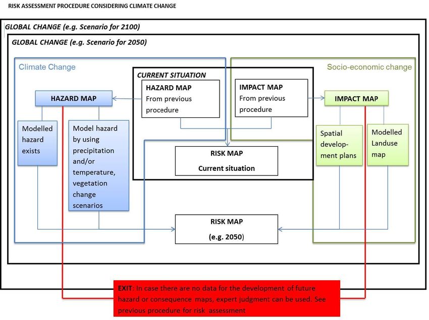
Content
Glossary .................................................................................................... 3

Scope of the document ............................................................................... 5

Executive Summary .................................................................................... 6

1. Introduction ......................................................................................... 11

2. Concept and approach........................................................................... 13

3. Future Risk Assessment and associated Uncertainties ............................... 17

  3.1 Earth system modelling and associated uncertainties ............................ 17

  3.2 Future climate-related hazards in the Danube macro-region .................. 23

  3.3 Changes in socio-economic context .................................................... 28

4. Risk changes for selected hazards under future climate ............................. 32

  4.1 Heat waves ..................................................................................... 32

  4.2 Floods ............................................................................................ 35

  4.3 Drought .......................................................................................... 36

  4.4 Wild fires ........................................................................................ 39

  4.5 Windstorms ..................................................................................... 40

5. Synergies, conclusions and follow up ...................................................... 41

  5.1 Thematic Pole 5 on Climate Change Adaptation in the South East Europe 41

  5.2 Synergies with other European programmes ....................................... 43

  5.3 Conclusions and follow up ................................................................. 45

Acknowledgements ................................................................................... 47

Annex 1 List of cited projects and programmes ............................................ 48

References .............................................................................................. 50

                                                                                                             2
Glossary

 Term      Explanation

           Climate change refers to a change in the state of the climate
           that can be identified (e.g., by using statistical tests) by
           changes in the mean and/or the variability of its properties,
           and that persists for an extended period, typically decades or
           longer. Climate change may be due to natural internal
           processes or external forcings such as modulations of the
           solar cycles, volcanic eruptions, and persistent anthropogenic
           changes in the composition of the atmosphere or in land use.
 Climate   Note that the Framework Convention on Climate Change
 change    (UNFCCC), in its Article 1, defines climate change as: “a
           change of climate which is attributed directly or indirectly to
           human activity that alters the composition of the global
           atmosphere and which is in addition to natural climate
           variability observed over comparable time periods.” The
           UNFCCC thus makes a distinction between climate change
           attributable to human activities altering the atmospheric
           composition, and climate variability attributable to natural
           causes (from IPCC, 2014, page 5).

           The potential occurrence of a natural or human-induced
           physical event or trend or physical impact that may cause loss
           of life, injury, or other health impacts, as well as damage and
           loss to property, infrastructure, livelihoods, service provision,
           ecosystems, and environmental resources. In this report, the
           term hazard usually refers to climate-related physical events
 Hazard    or trends or their physical impacts. Exposure: The presence of
           people, livelihoods, species or ecosystems, environmental
           functions, services, and resources, infrastructure, or
           economic, social, or cultural assets in places and settings that
           could be adversely affected (from IPCC, 2014, page 5).

                                                                               3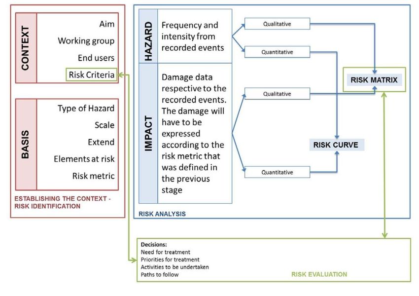
The propensity or predisposition to be adversely affected.
              Vulnerability encompasses a variety of concepts and elements
              including sensitivity or susceptibility to harm and lack of
              capacity to cope and adapt. Impacts: Effects on natural and
              human systems. In this report, the term impacts is used
              primarily to refer to the effects on natural and human systems
              of extreme weather and climate events and of climate change.
              Impacts generally refer to effects on lives, livelihoods, health,
Vulnerability
              ecosystems, economies, societies, cultures, services, and
              infrastructure due to the interaction of climate changes or
              hazardous climate events occurring within a specific time
              period and the vulnerability of an exposed society or system.
              Impacts are also referred to as consequences and outcomes.
              The impacts of climate change on geophysical systems,
              including floods, droughts, and sea level rise, are a subset of
              impacts called physical impacts (from IPCC, 2014, page 5).

                The potential for consequences where something of value is at
                stake and where the outcome is uncertain, recognizing the
                diversity of values. Risk is often represented as probability of
                occurrence of hazardous events or trends multiplied by the
Risk
                impacts if these events or trends occur. Risk results from the
                interaction of vulnerability, exposure, and hazard. In this
                report, the term risk is used primarily to refer to the risks of
                climate-change impacts (from IPCC, 2014, page 5).

                The process of adjustment to actual or expected climate and
                its effects. In human systems, adaptation seeks to moderate
                or avoid harm or exploit beneficial opportunities. In some
Adaptation
                natural    systems,   human    intervention  may    facilitate
                adjustment to expected climate and its effects (from IPCC,
                2014, page 5).

                The capacity of social, economic, and environmental systems
                to cope with a hazardous event or trend or disturbance,
                responding or reorganizing in ways that maintain their
Resilience
                essential function, identity, and structure, while also
                maintaining the capacity for adaptation, learning, and
                transformation (from IPCC, 2014, page 5).

                                                                                   4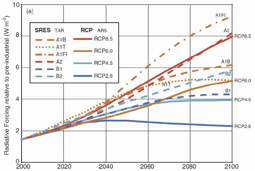
Scope of the document

According to the latest IPCC report the magnitude and frequency as well as
spatial distribution of a number of climate-related natural hazards is expected to
change. Climate change adaptation tops the agenda of governments as well as
regional and local authorities in most European countries. In order to design
climate change adaptation strategies the risk that various natural processes such
as heat waves, floods, drought, wildfires and storms pose on communities
(population, infrastructure, built environment, economic development) has to be
identified. However the risk is dynamic and may change in time. This change is
due to changes in frequency, magnitude and extent of natural hazards but also
changes of the elements at risk. The SEERISK project focuses on South East
Europe. One of the main products of the project is a common risk assessment
methodology for the partner countries. In this report, the status quo of future
risk assessment is presented together with an extension of this common risk
assessment methodology developed in SEERISK to include future change in order
to enable risk assessment under future scenarios in synergy with other European
projects and programmes.

                                                                                5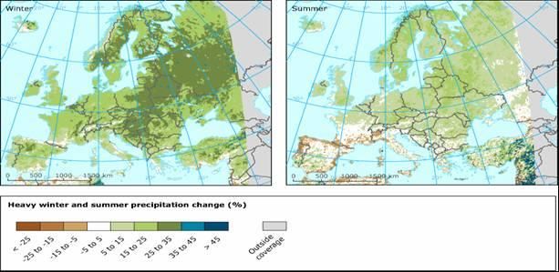
Executive Summary

Thematic Pole 5 on Climate Change Adaptation within the South East
Europe Transnational Cooperation Programme (SEE Programme) consists
of projects addressing climate change adaptation. These projects have the
common goal of contributing to the development of knowledge, measures,
mechanisms, policies (including local and national ones) to address the
adaptation to climatic impacts. The Joint Disaster Management risk
assessment and preparedness in the Danube macro-region (SEERISK)
project as well as its twin project - A network for the integration of climate
knowledge into policy and planning (ORIENTGATE) - are part of this Pole.

The general objective of our report is to identify the methodological steps
and existing knowledge for extending risk assessment performed in the
SEERISK (under present climate conditions) into the future under climate
change scenarios. The SEERISK common methodology for risk assessment
is the general framework which allows us to take into account the
potential for further climate and socio-economic evolutions to assess the
risks for climate-related hazards.

Risk is defined by the overlapping of hazard and impact (exposure and
vulnerability). Global environmental change (i.e. climate and socio-
economic change) should be considered in the risk assessment and in the
planning of prevention measures. Improvements in procedures for
downscaling climate have to be done in hazard mapping for risk
assessment and adaptation. The interaction with stakeholders is essential
for developing procedures and tools related to mapping impact for
adaptation. The lack of wide spread quantitative information on impact
and adaptation is still a challenge in the Danube Macro-region under
present conditions.

Assessment of future climate-related hazards can be done using global
and regional climate models driven by the scenarios describing external
perturbations such as changes in atmospheric compositions due to
increasing concentration of anthropogenic greenhouse gases (GHGs)
(figure I). Global climate models (GCMs) provide the boundary conditions
(typically at a spatial resolution from 50 km to 150 km) for regional
climate models (RCMs) which physically downscale the global signals at
finer spatial scales (less than 50 km). Besides dynamical downscaling,

                                                                            6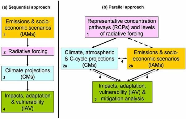
statistical downscaling methods are also applied to model results to reach
spatial resolutions from near 1 km to 10 km.

                                                 Probability
                                                                 Future risk
        Climate projections
                                                               Magnitude of impact

                Scenarios              Socio-economic projections

Figure I The concept of quantitative assessment of future risk under
climate change.

External factors imposed to climate models such as future GHGs
concentrations are derived from different future scenarios. Scenarios do
not predict the future but they help in better understanding uncertainties
and alternative evolution paths, in order to assess the feasibility of options
to be taken in the conditions of possible futures developments. Scientific
community has produced global quantitative scenarios of socio-economic
changes, including changes in demographics, technology, energy and
land-use either as SRES IPCC storylines or others consistent with the

                                                                                     7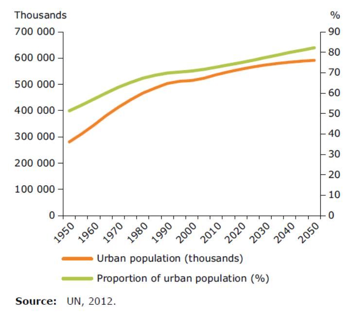
Representative Concentration Pathways (RCPs). RCPs are not linked to
any socio-economic scenarios, but each of them is consistent with many
socio-economic storylines because different socio-economic futures could
lead to similar changes in atmospheric GHGs concentrations. Future
impact can be shaped by regionally-modeled future projections in
demography, land-use and other socio-economic changes (Figure I).
Development plans from municipalities, regional or national governments
can provide exposure and vulnerability changes in the risk assessment,
too.

The Danube Macro-region has been already strongly affected by climate
variability and change. In the future, extreme high temperatures across
this area are projected to become more frequent and last longer. As for
precipitation, recent results indicate that the amounts of heavy
precipitation are projected to increase in both winter and summer. Urban
areas are prone to additional constraints due to human-made
environment. However, especially in summer, drought and water scarcity
will affect a large part of the Danube macro-region too.

Future impact changes in the Danube macro-region are mainly shaped by
demographic, land-use and other socio-economic changes like over all
Europe. In general, demographic changes are expected in: (1) age
composition; (2) population size and growth; (3) population
mobility/migration/urbanization. In the Danube Macro-region, as in all
Europe, the trend for the future is defined by an aging population. This
trend is expected to have a direct impact on the vulnerability of human
communities to natural disasters such as those analyzed in SEERISK and
ORIENTGATE projects (e.g. heat waves in urban areas, floods). According
to the European Environment Agency, the European urban areas are
expected to increase by 1% in 2020 in comparison to year 2000. One of
the most predominant land-use changes present in Europe (and in the
Danube Macro-region) is the increase of soil sealing due to both
urbanization and road infrastructure expansions. These expansions affect
the exposure and vulnerability of the society to heat waves and floods.

In the case of heat waves over the Danube Macro-region, the hazard
component (which is related to the increase in temperature) is expected
to change towards more frequent, persistent and strong episodes in the
future. The confidence associated to future climate projections based on
numerical experiments with climate models is highest for this hazard
compared with others analyzed in SEERISK and ORIENGATE projects. As
                                                                      8
for impact side, a typical indicator of exposure to heat waves that is
population census data from the areas affected is expected to increase
due to the trend of increased urbanization in the Danube Macro-region.
Vulnerability metrics such as the age distribution of population is also
expected to contribute to higher level of risk associated to heat waves due
to the aging trends present in the Danube Macro-region, too.

For the Middle Danube River Basin, studies show a pronounced increase in
flash floods due to more extreme weather events (torrential precipitation)
especially in the small basins (e.g. Sava and Tisza). The studies of the
Low Danube River Basin indicate an increase in flood frequency, too. Flood
events are projected to occur more frequently particularly in winter and
spring, although estimates of changes in flood frequency and magnitude
remain uncertain. The uncertainty of flood prediction is especially high in
small catchments. The uncertainties due to hydrological impact models
add to those coming from global and regional models. The risks associated
especially to urban floods are expected to increase due to increased flood
frequency (climate change), larger exposure (e.g. increased urbanization)
and higher vulnerability (e.g. soil sealing trends) in the Danube Macro-
region.

Climate change amplifies the frequency and severity of droughts. The
common feature across the Danube Macro-region countries is that all of
them are sensitive to both the variability and change in precipitation. The
expected climate evolution in this region is toward warmer and drier
summers. The southern parts of Hungary and Romania as well as the
Republic of Serbia, and Bulgaria are likely to face droughts and water
stress resulting in water shortages in the following decades (with a
stronger manifestation toward the end of this century). A common feature
of the Danube Macro-region is that the most vulnerable sector to drought
impact is agriculture. The impact of climate change on local agricultural
activities can be assessed by crop models coupled to the RCMs. Risks
related to food security in the Danube Macro-region are also influenced by
exposure (e.g. reduced agricultural areas) and vulnerability (e.g. propriety
fragmentation, aging population).

The hazard component of future risk in wild fires could be more reliable
compared with other risks as future changes in temperature and related
variables have relatively high certainty. The hazard of wild fires is
physically-related to drought hazard. How exposure and vulnerability add
their effects to that of changes in hazard component to shape the future
                                                                          9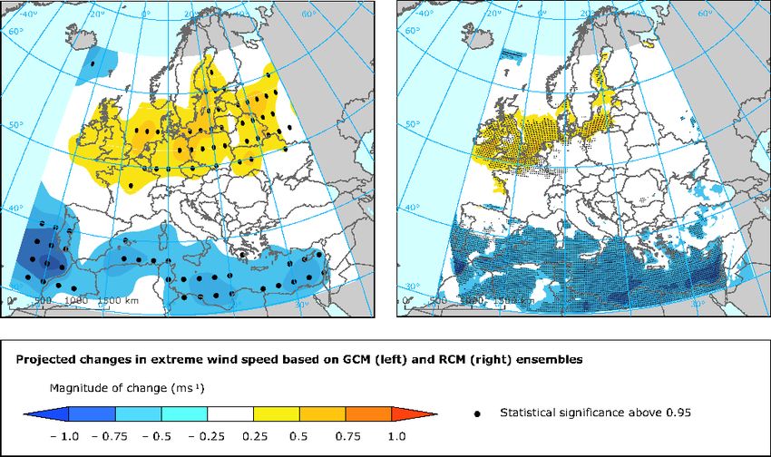
risks of wild fires in the Danube Macro-region is not very clear in the
present available literature.

The wind speeds during storm events increase significantly over large
parts of Central Europe by about 5 %. Analyzing extreme wind speeds and
the related loss potentials, enhanced speed values and risk of loss are
found over the northern parts of Central and Western Europe, whereas
significant reductions are found over southern Europe and the
Mediterranean. However, the present literature lacks analysis of risk
losses due to changing wind under future climate conditions in the Danube
Macro-region.

In the SEE Transnational Programme, the SEERISK project mostly
targeted the disaster management community while the ORIENTGATE
project was more adaptation-orientated. However, the two communities
share common interests, too. They are interested in seasonal climate
prediction and both use interdecadal climate information for assessing
hazards. Also, both communities have to fill the gap between climate
experts and stakeholders in understanding of climate change and raise
awareness of people on these issues. The involvement of stakeholders in
assessing climate-related risks and in finding ways to effectively use
climate predictive information is essential for both disaster management
and adaptation. Stakeholders have to be involved in an interactive way in
the process of climate-related risk assessment, climate prediction and
associated activities for risk reduction and adaptation.

                                                                       10
1. Introduction
The pace of climate change imposes increasing pressure on the
scientific community and on the rest of the society from the need of
improved knowledge on physical phenomena across multiple temporal and
spatial scales to demands for assessments of socio-economic exposure
and vulnerability to climate impacts in order to improve life quality
through appropriate adaptation measures (Figure 1.1). In recent decades,
changes in climate have caused impacts on natural and human systems
on all continents and across the oceans (IPCC, 2014). The geopolitical
distribution of impacts on human systems attributed to climate change
highlights different risks to climate-relating hazards arising from
differences in vulnerability and exposure due to non-climatic factors and
socio-economical inequalities.
Figure 1.1 Adaptation cycle
11An effective management of the risks associated with climate
changes and in particular with the changes in the frequency and intensity
of weather- and climate-related extreme events (e.g. heat waves, floods
and droughts, wild fires) is needed at all decisional levels – global,
regional and local communities.
Recently, the scientific community has made significant
advancements in assessing climate predictability and associated
uncertainties on various spatial and temporal timescales. However, these
advancements do not cross immediately the screen of computers to
measurably increase the quality of people lives and socio-economic
cohesion of the European Union and of the world. The need for integration
of climate information in the decision process at policy-makers levels as
well as in the long-term planning activities in the private/industry sectors
is nowadays well accepted and important steps have been made in this
direction during the last years. Human society has three different
response approaches to climate change: mitigation, adaptation and
acceptance of a certain level of climate-related damages. The best
solution is probably a mixture of all these approaches. At global and
regional levels, efforts have been taken towards improving people
awareness on climate changes and potential effects, identifying and
implementing measures to mitigate negative impacts and/or exploit new
opportunities associated with these changes. From web-based platforms
presenting climate-related information in an easy-to-use manner (e.g.
www.climateadaptation.eu) to web-based tools designed to address
specific societal challenges in relation to climate change, a variety of user-
oriented applications aims to deliver climate information in a form fitted
for the decisional process.
Under present climate, knowledge about local features of climate
variability and change demands an integration of standard meteorological
observations, other in situ information, and satellite and weather radar
data. As for the future climate conditions, the challenge is to downscale
model results to finer temporal and spatial scales relevant to local analysis
to deliver climate products, services and plan adaptation. Last but not
least, the spatially-detailed mapping of climate-related hazards in local
area have to be fully coupled with exposure and vulnerability of population
and infrastructure in order to continually assess the climate related risks
to which one has to adapt for a sustainable development.
The general objective of our report is to identify and review the
state of art in the methodologies for extending risk assessment performed
in the SEERISK (under present climate conditions) into the future under
climate change scenarios. The common methodology for risk assessment
12developed in the SEERISK project (SEERISK Consortium, 2014) is the
general framework which allows us to take into account the potential for
further climate and socio-economic evolutions to assess the risks for
climate-related hazards.
As the document of the Thematic Pole 5 on Climate Change
Adaptation reveals, the South East Europe Transnational Cooperation
Programme (SEE Programme) consists of a number of projects that
shared a concrete approach towards climate change adaptation measures,
a cross-cutting theme to several projects and Areas of Intervention. The
SEE projects which address the climate change adaptation had the
common goal of creating knowledge, measures, mechanisms, policies for
coping with climatic episodes that endanger environment and human
society through local and national climate-related policies. The projects
from the Thematic Pole 5 on Climate Change Adaptation addressed
different sectors (forestry and agriculture, drought, water & coasts, urban
adaptation and health, floods, disaster management). They are aiming at
streamlining their results towards strategies and policies that address
climate change adaptation to strengthen the value of their outcomes
(http://www.southeast-
europe.net/en/achievements/capitalisation_strategy/pole7/thematicpole5c
limatechangeadaptation).
The present report aims to respond to the challenges identified by
European Commission and viewed as priorities in the SEE work
programme, in synergy with the results from the Thematic Pole 5 on
Climate Change Adaptation, in particular to the one concerning the need
to increase Europe's resilience to crises and disasters. The outcomes
based on a risk assessment approach will provide support for the
development of innovative adaptation and long term risk reduction
options, fine-tuned to specific natural and socio-economic conditions
across Danube Macro-Region.
2. Concept and approach
Methodological steps for extending risk assessment (under future
climate change) which has been performed in the SEERISK (under present
climate conditions) are based on (1) the EU guidelines for risk assessment
and mapping (EU, 2010); (2) the ISO31010 (IEC/FDIS 31010 2009); (3)
Climate change, impacts and vulnerability in Europe; (5) Adaptation in
13Europe Addressing risks and opportunities from climate change in the
context of socio-economic developments; (4) common risk assessment
methodology for risk assessment and adaptation in the Danube macro-
region (see figure 2.1).
Figure 2.1 The structure and workflow for SEERISK common risk
assessment methodology (SEERISK Consortium, 2014).
One of the main products of SEERISK is the common risk
assessment methodology for risk assessment and mapping (SEERISK
Consortium, 2014). The Common Risk Assessment Methodology (Figure
2.1) incorporates three steps: 1. establishing the risk context and risk
identification, 2. risk analysis and 3. risk evaluation. The hazard and
impact analysis which are the two main components of risk analysis are
14based on data from previous events. However, the spatial and temporal
patterns of hazards as well as the socioeconomic context are subject to
change in the future.
According to the latest report of the Intergovernmental Panel for
Climate Change (it is likely that the frequency and the magnitude of some
hazard types might change in the near future (IPCC, 2012). In more
detail, according to the IPCC report “a changing climate leads to changes
in the frequency, intensity, spatial extent, duration and timing of weather
and climate extremes and can result in unprecedented extremes” (IPCC,
2012, p.111). As a consequence weather related phenomena are also
expected to change. However, the severity of the impacts does not
depend only on the process itself but also on the level and spatial
distribution of vulnerability and exposure. Risk is the overlapping area
from hazard and vulnerability (figure 2.2), so changes in the later will lead
to changes in risk. Global environmental change (i.e. both meaning
climate and socio-economic change should be considered in risk
assessment and in the planning of prevention measures.
Figure 2.2 Definition of risk in relation with hazard and exposure and
vulnerability (i.e. impact).
Figure 2.3 illustrates how global change is taken into consideration
in the common risk assessment methodology. The inner frame describes
the current situation, whereas the outer frames describe the situation for
future scenarios (for instance, targeting on time horizons of 2050 and
2100). In order to assess the change in hazard, climate models that can
15simulate the weather variables (e.g. precipitation, temperature etc.) may
be used. On the other hand, the changes in vulnerability will depend on
the socio-economic (e.g human-made changes in land use in the study
area). These changes can also be modelled or they can be assessed by
using spatial development plans from municipalities, regional
governments or national governments. If model data or information
required for assessing the change in hazard and/or vulnerability are not
available, the exit strategy has to be used, which is based on expert
judgment (Figure 2.4).
Figure 2.3 Consideration of changes in climate and in socio-economic
change are essential in risk assessment (Source: Malet et al., 2012).
Special procedures and tools are needed to couple downscaled
weather and climate with impact data for risk assessment. Improvements
in integration of observations and model results will support downscaling
procedures in hazard mapping for risk assessment and adaptation. The
interaction with stakeholders is essential for developing procedures and
tools related to climate-related hazards and impact and adaptation. The
lack of wide spread quantitative information on impact and adaptation is
still a challenge.
16Figure 2.4 The extension of the SEERISK common assessment
methodology to include global environmental change.
3. Future Risk Assessment and associated Uncertainties
3.1 Earth system modelling and associated uncertainties
In order to describe the future evolution of the climate variables
(e.g. air temperature, precipitation) for further assessing climate-related
hazards, most of studies use global and regional climate models driven by
the scenarios describing external perturbations, such as changes in
17atmospheric compositions due to increasing concentration of
anthropogenic greenhouse gases (GHGs). Generally, a climate model
describes in mathematical language, based on physical laws, the behavior
of the analyzed system starting from an initial state and constrained by
external and boundary conditions. The climate system of the Earth
consists of interacting components: the atmosphere, the hydrosphere
(planetary ocean and continental hydrological network), the cryosphere
(e.g. continental snow, glaciers, permafrost, ice caps and sea-ice), the
land surface and the biosphere. In order to model the Earth system is not
enough to separately describe its components, but one has to simulate the
processes linking them, too (e.g., Peixoto and Oort, 1992). Due to the
synergy between its components, the response of the Earth system to
external perturbation differs from the sum of individual responses
provided by the above-mentioned subsystems. Climate modelers have
brought separate components together, firstly as coupled models of
atmospheric and oceanic circulation (with sea ice dynamics), and secondly
as Earth system models (ESMs) which interactively add biological and
geochemical processes (including the carbon cycle) to coupled ocean-
atmosphere component (Foley et al., 1998). Global climate models
(GCMs) provide the boundary conditions (typically at a spatial resolution
from 50 km to 150 km) for regional climate models (RCMs) which
physically downscale the global signals at finer spatial scales (less than 50
km). Besides dynamical downscaling, statistical downscaling methods are
also applied to model results to reach spatial resolutions from near 1 km
to 10 km.
External factors imposed to climate models - such as future GHGs
concentrations - are derived from different future scenarios. Scenarios of
GHGs emissions/concentrations and other drivers are used to assess the
impact of a range of human activities on Earth system components.
However, one has to take into account that changes in climate are major
drivers of changes in both natural and human systems (through changes
in technology, economies, lifestyle and policy). Scenarios do not predict
the future but they help in better understanding uncertainties and a range
of evolution paths, in order to assess the feasibility of options for
adaptation to climate change.
The first approach in designing scenarios was a linear one consisting
of the following steps: (1) producing socio-economic scenarios that lead to
different future GHGs and aerosol emissions (i.e. the IPCC SRES
scenarios); (2) evaluating the effects of those emissions on
concentrations; (3) describing the influences on the climate system, and
(4) assessing the implications of those climate changes, along with socio-
18economic futures and other environmental changes, on natural and
human systems (figure 3.1.2 a).
Figure 3.1.2 Approaches to the development of global scenarios: (a)
previous sequential approach; (b) proposed parallel approach. Numbers
indicate analytical steps (2a and 2b proceed concurrently). Arrows indicate
transfers of information (solid), selection of RCPs (dashed), and
integration of information and feedbacks (dotted). Source: Moss et al.
(2008).
The IPCC SRES scenarios are based on different driving forces of
GHGs emission changes, including population growth and socio-economic
development. These drivers span a range of future scenarios that might
influence GHG sources and sinks, such as the energy system and land use
change. The SRES team defined stories (named A1, A1T, A1F1, A1B, A2,
B1 and B2), describing the relationships between the forces driving GHGs
19and aerosol emissions and their evolution during the 21st century
(Nakicenovic al., 2000). Each story represents different demographic,
social, economic, technological, and environmental developments that
increasingly diverge with time (http://www.ipcc.ch/pdf/special-
reports/spm/sres-en.pdf).
Another recent approach is designed for a better integration
between socio-economic driving forces, changes in the climate system,
and the vulnerability of natural and human systems. Instead of starting
from socio-economic scenarios that lead to different GHGs emissions, the
new scenarios start with future GHGs and aerosol concentrations (figure
3.1.2b).
Figure 3.1.3 Projected radiative forcing (W ^m-2) over the 21st century
from the SRES and RCP scenarios. Figure from IPCC AR5 WGII, Chapter 1.
20These new scenarios described in the Moss et al. (2008) are the
Representative Concentration Pathways (RCPs). The RCPs can be
simultaneously used either by Earth System Models (ESMs) to explore
future changes in physical and biogeochemical responses to changing
atmospheric composition and radiative forcing, or by Integrated
Assessment Models (IAMs) to explore alternative socio-economic
conditions that would result in such future atmospheric composition
changes (figure 3.1.2b) (Moss et al., 2008). During the parallel stage of
the new approach, climate modelers are performing new climate
experiments with their models to produce climate projections using the
time series of concentrations and land use from the four RCPs. These
model projections will be used to construct new climate scenarios for
application in Impacts, Adaptation, and Vulnerability (IAV) and IAM
studies (figure 3.1.2b) (Moss et al., 2008).
The new approach means that scientific community has to produce
quantitative scenarios of socio-economic changes, including changes in
demographics, technology, energy and land-use consistent with the RCP
pathways. RCPs are not linked to any socio-economic scenarios, but each
of them is consistent with many socio-economic stories because different
socio-economic futures could lead to similar changes in atmospheric
composition. The socio-economic stories produced by the scientific
community can then be used as a common set of assumptions by the IAM
and IAV communities. The IAV community combines these with results
from the ESM community based on RCPs to examine climate change
impacts, adaptation options, and vulnerability to climate change. Both
SRES and RCPs scenarios are illustrated for comparison in figure 3.1.3.
RCP8.5 was developed to represent a high-end concentration scenario
while RCP2.6 represents a GHGs concentrations due to extremely strong
mitigation scenarios (van Vuuren et al., 2011a). RCP 4.5 is a medium
GHGs concentration scenario (Thompson et al., 2011).
Society has three different response approaches to climate change:
mitigation, adaptation and acceptance of unavoidable climate damages.
The best solution seems to be a combination of these approaches. For
elaboration of climate change policy is necessary to produce information
on: (1) what mitigation actions might be required in order to produce a
climate outcome; (2) what will be the potential for adaptation; (3) what
unavoidable impacts might occur for a range of climate change projection
are important information. In the process of the policy elaboration, one
must trade off between the relative costs, benefits, risks, and unexpected
side effects of various levels and rates of climate change when planning
climate change policy.
21In the context of climate risks assessments little distinction is been
usually made between long and short term needs for responding to
climate impact. Climate variability is important on short time horizon
(usually, on intraannual and interannual scales) while climate change is
acting on longer term, beyond decadal scale. The SEERISK project focused
especially on the short term climate due to the fact that its products were
designed mainly for disaster management community. On the other hand,
the ORIENTGATE project addressed more the issues related to long term
climate. However, planning adaptation requires information on both
variability and climate change and the SEERISK and ORIENTGATE
approaches have to be merged.
Few policies are designed to operate on interdecadal timescale
because one would avoid committing resources for which there is no short
term return and partially due to the uncertainties in the future projections.
Although observed trends in climate change are expected to continue,
there is considerable uncertainty about the precise rate of change and its
concrete impact. For example, there are uncertainties associated with
using different models, scenarios and downscaling methods as well as
differences in the scales, projection periods and domains of interest where
they are applied (Tiago et. al, 2014).
The climate change is the result of the interaction of the natural
Earth system with anthroposphere (consisting of human systems).
Changes in ecosystems, natural resources, economic activities and
infrastructure, and human well-being, depend not only on climate change,
but also on other changes in the environment (depicted in environmental
scenarios) and the capacity of societies and economies to buffer and adapt
to impacts (addressed in scenarios of vulnerability and adaptive capacity).
Closer integration of scenarios is required to address feedback loops and
other issues, such as the ecological and economic implications of different
sets of adaptation and mitigation policies (Tiago et. al, 2014).
From the adaptation perspective, it is important to assess the range
of all possible changes in relation to their associated uncertainties. A part
of uncertainties in future projections are due to theoretical limitations in
modeling climate and its feedbacks with ecosystems and human systems.
They are intrinsic to science, so certain levels of uncertainties will be
always present and those must be included in decision-making processes.
Adaptation to climate change raises the challenges for long-term policy
planning under these unavoidable levels of uncertainties (Tiago et. al,
2014).
223.2 Future climate-related hazards in the Danube macro-region
Europe is strongly affected by climate variability and change (e.g.
IPCC, 2012; IPCC 2013; IPCC, 2014). European Environment Agency
reveals that since 1880 the average length of summer heat waves over
Western Europe doubled and the frequency of hot days almost tripled
(http://www.eea.europa.eu/data-and-maps/indicators/global-and-
european-temperature/global-and-european-temperature-assessment-8).
Number of combined tropical nights (minimum temperature greater
than 20ºC) and hot days (maximum temperature greater than 35ºC) are
projected to become more frequent and last longer during this century
(Fischer and Schär 2010, IPCC 2013) in the Danube macro-region as
figure 3.2.1 shows.
.
Figure 3.2.1 Changes in extreme temperature for two future periods,
relative to 1961-1990. Extreme temperatures are represented by the
combined number of hot summer (June-August) days (TMAX>35°C) and
tropical nights (TMIN>20°C). All projections are the average of 5 Regional
Climate Model simulations of the EU-ENSEMBLES project using the IPCC
SRES A1B emission scenario for the periods 1961-90, 2021-2050 and
2071-2100 (Fischer and Schär, 2010. Maps and caption from Environment
Protection Agency. http://www.eea.europa.eu/data-and-
maps/figures/projected-average-number-of-summer-1).
23Figure 3.2.2 Projected changes in heavy precipitation (in %) in winter and
summer from 1971-2000 to 2071–2100 for the RCP8.5 scenario based on
the ensemble mean of different regional climate models (RCMs) nested in
different general circulation models (GCMs) obtained in the EURO-CORDEX
initiative (http://www.euro-cordex.net/). Maps and caption from
Environment Protection Agency (http://www.eea.europa.eu/data-and-
maps/figures/projected-changes-in-20-year-2 ).
As for precipitation, recent results indicate that the ensemble mean
projects show a statistically significant increase in large parts of central
Europe and northern Europe of up to about 30 % and a decrease (up to
40 %) in southern Europe between 2071-2100 and 1971-2000 (Jacob et
al., 2014). Furthermore, the amounts of heavy precipitation are projected
to increase in both winter and summer over a large part of Europe and in
the Danube macro-region (figure 3.2.2). Urban areas are prone to
additional constraints due to human-made environment. As for as
extreme winds, the model results do not suggests significant changes over
the Danube macro-region under climate change scenarios (figure 3.2.3).
The new scenarios mentioned in section 2.1 (RCPs) show a
consistent picture with the SRES scenarios, even though the details are
different due to different radiative forcing. Examples based on
24temperature and precipitation projections for Danube Macro-region under
RCP 4.5 scenario are illustrated in figures 3.2.4, 3.2.5, 3.2.6, and 3.2.7.
Climate model results reveal mean temperature increase in winter (up to
2ºC for 2012-2050 vs. 1971-2000) and summer (reaching 2.5ºC for 2012-
2050 vs. 1971-2000) over our region of interest (figure 3.2.5 and 3.2.7).
Under RCP 4.5 scenario, climate projections indicate summer precipitation
reductions up to 9% in 2021-2050 compared to 1971-2000 over the
Danube macro-region (figure 3.2.6).
Figure 3.2.3 Ensemble mean of changes in extreme wind speed (defined
as the 98th percentile of daily maximum wind speed) for A1B (2071–
2100) relative to 1961–2000. Left: based on 9 GCMs. Right: based on 11
RCMs. Coloured areas indicate the magnitude of change (unit: m s−1),
statistical significance above 0.95 is shown by black dots. Maps and
caption from Environment Protection Agency
(http://www.eea.europa.eu/data-and-maps/figures/future-changes-in-
european-winter).
Climate model results presented here and others such as those
provided by ORIENTGATE, ENSABLES, and EuroCORDEX are the base for
mapping future hazards in the limits shaped by the unavoidable
25uncertainties. Future changes in temperature and related variable have
highest certainty. The certainty related to the future evolution of
precipitation is less reliable than temperature changes (ICPDR, 2013). The
certainty of changes in the water storages snow and ice is relatively high,
too. Changes in winter precipitation from snow to more rain are very
likely, but the quantitative projected changes are less reliable.
Figure 3.2.4. Differences in the ensemble mean of winter precipitation (in
%) between the intervals 2021-2050 and 1971-2000 using conditions of
RCP 4.5. The ensemble means were computed using 25 numerical
experiments with global climate models taken from CMIP5 database.
The future-projected runoff, evapotranspiration and groundwater are
all rather uncertain. Future changes in water availability depend largely
on precipitation, which might decrease in summer, especially in the
southeast of the Danube basin with a strong tendency to water stress
(ICPDR, 2013). Projections of extreme hydrological events are generally
more uncertain than changes in the mean water availability. Although
there are uncertainties in climate change impacts on low flows, droughts
and water scarcity, these are more reliable than changes in floods which
show larger uncertainty.
26Figure 3.2.5. Differences in the ensemble mean of winter temperature (in
°C) between the intervals 2021-2050 and 1971-2000 using conditions of
RCP 4.5. The ensemble means were computed using 25 numerical
experiments with global climate models taken from CMIP5 database.
Fgure 3.2.6. Differences in the ensemble mean of summer precipitation
(in %) between the intervals 2021-2050 and 1971-2000 using conditions
of RCP 4.5. The ensemble means were computed using 25 numerical
experiments with global climate models taken from CMIP5 database.
27Figure 3.2.7. Differences in the ensemble mean of summer temperature
(in °C) between the intervals 2021-2050 and 1971-2000 using conditions
of RCP 4.5. The ensemble means were computed using 25 numerical
experiments with global climate models taken from CMIP5 database.
Through the innovative approach of coupling predictive climate
information with specific socio-economic background (impact assessment)
one could provide support methods and tools for a better climate- risk
management at various time-scales and on a more coherent basis at the
Danube macro-region level.
3.3 Changes in socio-economic context
The assessment of socio-economic changes usually requires socio-
economic scenarios. A socio-economic scenario is a combination of
quantitative projections and qualitative information (such as storylines)
that define a plausible future (Carter et al., 2007). Historically, scenarios
of global futures were mostly used to assess the plausible evolution range
of global GHGs emissions and concentrations imposed on climate models
as external conditions. The impact/adaptation/vulnerability (IAV) research
community has rather analyzed the consequences of a certain local
increase in a climate variable (e.g., 1°C increase in air temperature
28compared with a reference interval), without using the global socio-
economic scenarios.
Producing regional, national and sub-national scenarios at long time
scales is a complex endeavour (e.g. Gaffin et al., 2004; Theobald, 2005;
Lempert et al., 2006; Grübler et al., 2007; Groves and Lempert, 2007;
Hallegatte et al., 2010; Van Vuuren et al., 2010b). In some cases there
are local scenarios - such as city scenarios designed to support urban
planning. However, these scenarios are not connected to global ones, in
which global environmental change could be fully represented. Moreover,
they usually consider time horizons of less than 30 years. Urban scenarios
with a 2100 time horizon are not generally available now, yet such
scenarios would be of relevance to the understanding of urban ‐ scale
climate change impacts. Thus, in our context is difficult to exemplify with
socio-economic scenarios for Danube macro-region to assess the impact
part of future risks in our domain of interest. What we can present from
the available literature is some qualitative information about future
impacts in the region based on identified European trends in the indices of
exposure (e.g. total population, urban areas, etc) and vulnerability (e.g.
age distribution, land use, etc) that partially shape the socio-economic
impact.
3.3.1 Demographic changes
Demographic changes are expected in: (1) age distribution; (2)
population size and growth; (3) population
mobility/migration/urbanization. In more detail and as far as the age
distribution in Europe is concerned, the main characteristic and trend for
the future is an aging population which is expected to have a direct impact
on the vulnerability of societies to natural disasters. In contrast with the
high birth rates of the decades following the Second World War, since the
1970’s negative trends in the population structure have been observed
(Stula and Linz, 2010).
The low birth rates in combination with low mortality rates have led
to an ageing population. This ageing population may be more vulnerable
to some hazard types (e.g. heat waves) and less able to adapt to climate
change (low adaptive capacity) (ESPON, 2013). The percentage of elderly
in Europe is expected to increase from 17.1% to 30% in 2060 whereas
the percentage of people more than 80 years old will triple by 2060
(Eurostat, 2008 and EEA, 2012). Even though the available literature does
not provide us quantitative estimates, these European trends are expected
to take place in the Danube macro-region, too.
29Population growth and urbanization may also have an indirect
impact on the vulnerability to natural hazards since the urban sprawl will
be responsible for more paving of surface, and higher temperature in
cities (heat island effect).
Figure 3.3.1 European urban population trends (EEA, 2012)
Increasing urban land intake and urbanization have resulted in the
increase of vulnerability of European cities to climate change related
hazards such as heat waves, flooding and drought. This has been obvious
through the consequences of events such as the flooding of river Elbe in
2002 (EEA, 2012) The European urban population trends are
demonstrated in Figure 3.3.1 According to the United Nation Global Report
on Human Settlements - Cities and Climate Change (UN-Habitat, 2011)
although the percentage of people living in cities of less than 500,000 will
slightly decrease, the percentage of people living in megacities (more than
10 million people will increase (from 8.2% in 2000 to 10.4% in 2020 (UN-
Habitat, 2011).
303.3.2 Land use change
The European Environment Agency (EEA) has produced a report on
land use in Europe with a focus on land-use outlooks for the year 2020.
More specifically, the land-use outlooks cover two dimensions: changes
between different land-cover categories and changes within land cover
categories. According to this report urban areas are expected to increase
by 1% in 2020 in comparison with the 2000 level. Agricultural land use is
expected to decrease in contrast to the forest area which is expected to
increase by 5% between 2000 and 2020 (EEA, 2010). The study of Pérez-
Soba et al. (2010) presents modelling approaches of land-use for Europe
together with theirs associated uncertainties.
As far as land cover change and the impact on the consequences of
natural hazards are concerned, one of the most predominant changes is
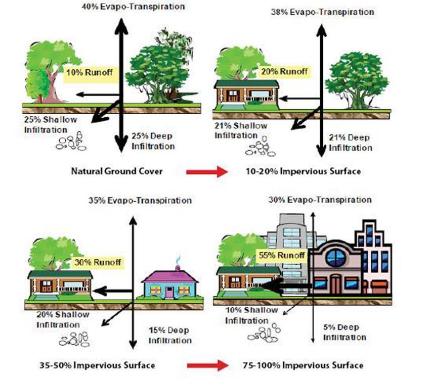
the increase of soil sealing. Soil sealing is “the permanent covering of an
area of land and its soil be impermeable artificial material such as asphalt
and concrete” (EC, 2012). The impact of soil sealing on the hydrological
cycle is schematically shown in Figure 3.3.2. Soil sealing in built up areas
may decrease the water storage capacity of the floodplain leading to an
increase of flood risk and flood damage. Some European examples may
highlight the size of the problem: for example, the Rhine and the Elbe
have lost four 80% and 86% of their natural floodplains (EC, 2012). It is
clear that the problem will continue since everyday an additional 27
hectares of land is sealed in Europe, primarily due to the steady expansion
of the transport network (IASS, 2013). Soil sealing plays also an
important role in the urban temperature and the development of the
urban heat island. Soiled surfaces in cities may be up to 20% warmer
than unsealed or vegetated ground (IASS, 2013).
3.3.3 Other socio-economic change
Other socio-economic changes such as unemployment, financial
crisis, changes in the Gross Domestic Product (GDP) can affect the overall
impact of natural hazards in a community. According to Kriegler et al
(2012), only a limited number of studies based on socio-economic
scenarios have been developed to support climate change adaptation.
Studies that have considered socio-economic scenarios include the work of
Arnell et al. (2004) and Rounsevell et al. (2006).
31Figure 3.3.2 Impact of soil sealing on the hydrological cycle (EC, 2012)
4. Risk changes for selected hazards under future climate
4.1 Heat waves
Heat-waves defined as prolonged spells of anomalous high
temperature that lasts from several days to weeks have a strong impact
on the society including a rise in mortality and morbidity. Heat waves also
affect infrastructure (power, water, and transport). The heat wave has no
universal definition. The term is relative to the usual weather in the
analyzed region (Lass et al., 2011). The World Meteorological Organization
32recommended as the definition of heat wave the interval when the daily
maximum temperature of more than five consecutive days exceeds the
average maximum temperature by 5 Celsius degrees, the reference period
being 1961–1990 (Frich et al. 2002). In some cases, there are definitions
implemented in national legislation such as the Romanian regulation that
indicates the socio-economic measures for heat wave intervals defined as
two consecutive days with maximum air temperature greater than 37º C
(or with the maximum daily value of thermal comfort index greater than
80). In Hungarian regulation a heat wave is defined as the interval of
three consecutive days with the day average temperature above 27ºC.
In the case of heat waves, the hazard is the increase in
temperature. Future changes in temperature and related variable have
relatively high certainty (ICPDR, 2013) that is why investigating future
changes to heat wave-related hazards lead to results with a low level of
uncertainty. The main problem in building hazard maps for heat wave at
the urban scale is the lack of high resolution air temperature measured
there. Downscaling methodologies are needed for different urban areas in
the Danube macro-region to describe how they respond to climate
variability and change. Usually, this type of methodologies are based on
regional climate simulations with limited-area models running at
resolution finer than 10 km coupled with the Town Energy Balance (TEB)
(Mason et al., 2000) scheme as described in the paper of Hamdi et al.
(2014). In order to downscale the regional climate data to an urban scale
of 1-km resolution, a standalone surface scheme including TEB has to be
used. The results of this type of simulations can add insights in the
interactions between climate change and the urban heat island and allow
the study of the UHI during heat-wave episode under both present and
future conditions.
The hazard component of the future changes in heat wave risk can
be derived using the high-resolution dynamical downscaling methodology
developed by Hamdi et al. (2014) applied to climate projection results
such those exemplified in the Chapter 3, section 3.2. These results from
climate projections are taken from both CMIP 3 data (under SRES
scenarios) and CMIP 5 (under RCPs). The CMIP 3 and CMIP5 are the
results of numerical experiments with global climate model. Another
approach could be to start the fine downscaling procedure from the results
of regional climate models (e.g. ENSEMBLES for CMIP 3 and EuroCORDEX
for CMIP 5).
As for impact side, exposure refers to the inventory of elements at
the location at which hazard events may occur. A typical indicator of
exposure to heat waves is population census data from the areas affected.
33Vulnerability metrics is defined by the lack of material or social resources
to cope with or mitigate the effects of extreme heat. The vulnerability
depends on factors such as: (1) physical exposure (working outside, living
in a home without air-conditioning in urban area etc.); (2) sensitivity to a
given heat exposure (e.g. age - children and elderly people are more
vulnerable, sex - women tend to be more vulnerable to heat stress than
men, health condition due to pre-existing respiratory and cardiovascular
diseases, and body mass); (3) access to treatment (such as lack of
information or medication due to poverty) (Buscail et al. 2012).
The final risk map is generated from the combination of the hazard
index, and the exposure and vulnerable index. In the concrete case of
Arad municipality, the future risk mapping could follow the present
qualitative approach by using a risk matrix to superimpose the hazard and
impact components. We could imagine a range of scenarios in which we
assume, for instance, that (1) total population, city skyline and built areas
remain roughly the same (i.e. the exposure), but with changes in hazard
(more frequent, persistent and strong heat waves) and vulnerability (e.g.
aging population trend) – the business as usual scenario; (2) the total
population remain the same, city skylines and built area are modified to
adapt to a stronger thermal stress but with higher level of hazard
occurrence and higher vulnerability – the adaptive scenario. The two
scenarios demand different risk matrices to reflect levels of (no)
acceptable risks.
Also, in order to better map the future risks, the impact should be
decomposed into exposure and vulnerability to use their modeled
projections. This was not the case for the risk mapping of heat wave risk
in Arad (Romania) performed in the SEERISK project under the present
climate conditions. In this regard, ORIENTGATE project offers examples of
good practices in using exposure and vulnerability assessment under
climate change scenarios for their case studies of Veszprem city and 13th
district of Budapest.
The downscaled data from model results can help in identifying a
quantitative relation between hazard and impact (e.g. Michelozzi et al.,
2010). These elements together with scenario-derived data on impact can
provide risk curves instead of risk matrices. Furthermore, based on
business as usual and adaptive scenarios one could estimate the costs of
feasible adaptive measures and the benefits in downgrading health
population vulnerability.
344.2 Floods
In the flood case, the future changes projections of hazard are more
uncertain than in the case of heat waves due mainly to the fact that the
level of certainty related to the future evolution of precipitation is less
reliable than temperature changes (ICPDR, 2013). Also, projections of
extreme hydrological events are generally more uncertain than changes in
the mean water availability. Furthermore, impact assessment of climate
variability and change on floods requires projections on both high spatial
resolution and short-duration precipitation extremes. The relevant time
scales can be very short, which needs effective statistical downscaling of
climate model results (Arnbjerg-Nielsen, 2012). Stochastic weather
generator and regression-based downscaling methods are usually applied
to generate high resolution climate data both in time and space.
Vulnerability and risk mapping and adaptation approach which are
developed for flood cases have to take higher uncertainties into account.
Most of the available future projections are based on the IPCC SRES
scenarios A1B and A2 (e.g. ICPDR, 2013). The 4th IPCC assessment
report predicts that climate change will increase the occurrence of flash
floods across the EU river basins, too. In contrast with the SEERISK flood
case studies which were performed under present climate conditions (for
Senica in Slovakia and Sarajevo Bosnia & Hertzegovina; see SEERISK
Consortium, 2014), hazard assessment of future floods needs hydrological
models coupled to downscaled climate results to simulate changes in
future stream flows and other local hydrological processes.
For the Middle Danube River Basin, studies based on IPCC SRES
scenarios show a pronounced increase in flash floods due to more extreme
weather events (torrential rainfall) especially in the small basins (e.g.
Sava and Tisza). The studies of the Low Danube River Basin indicate an
increase in flood frequency, too. Flood events are projected to occur more
frequently particularly in winter and spring, although estimates of changes
in flood frequency and magnitude remain uncertain. The uncertainty of
flood prediction is especially high in small catchments (ICPDR, 2013). The
scale and frequency of floods are likely to increase due to climate change
- which will bring higher intensity of rainfall but inappropriate river
management and construction in flood plains which reduces their capacity
to absorb flood waters contribute to amplify the natural hazard. Also, the
number of people and economic assets located in flood risk zones
continues to grow. This leads to a number of new challenges to flood risk
management.
35You can also read