Chapter 8. Transportation Element - Kershaw County
←
→
Page content transcription
If your browser does not render page correctly, please read the page content below
Chapter 8. Transportation Element

The transportation‐land use connection influences both land use and transportation planning.
While the most significant role that transportation plays in land development is in providing
access, transportation facilities serve as a significant element of the built environment, creating
both connections and barriers. For instance, a high‐volume, four‐lane highway may connect key
areas of a community for vehicular travel, but safety concerns can deter pedestrians who need
to cross the highway to get to resources on the other side. Traffic congestion on a thoroughfare
can also be a barrier, causing motorists to seek alternative routes through residential areas. An
understanding of these relationships is critical to solving and even preventing transportation
related problems such as congestion, higher energy consumption, reduced air quality, threats
to public health and safety, and decreased access to services and employment.

Debate on the relationship between transportation and land use typically hinges on whether
the transportation network should be planned to accommodate anticipated land uses and
growth, or the transportation network should evolve organically to accommodate traffic
generated by the location of land uses and subsequent growth patterns. Ideally, transportation
networks should be planned to anticipate and accommodate future needs. However, funding
for costly transportation infrastructure is limited, particularly at the local level, with resources
focused on alleviating immediate problems such as congestion, road maintenance, and safety
issues caused by increased traffic volume.

As the dominant mode of travel in the United States since the Second World War,
accommodation of the automobile has been a significant factor in land use development.
Residential areas have evolved from walkable neighborhoods to subdivisions focused on
optimum vehicular access. In recent years, public concern about issues such as traffic
congestion, energy conservation, and air quality have resulted in a broadening of
transportation planning to focus on the full range of transportation options.

While roads comprise the majority of most transportation systems, they are not the only viable
component. Effective transportation systems are built upon a broad, multi‐modal network of
options that include rail, air, shipping, public transit, and pedestrian and bicycle systems. In
general, a transportation system can be defined as any means used to move people and/or
products. The Transportation Element provides an analysis of transportation systems serving
Kershaw County including existing roads, planned or proposed major road improvements and
new road construction, existing and proposed transit projects, and proposed and existing
pedestrian and bicycle facilities and projects.

A. ROAD NETWORK

According to the 2017‐2022 South Carolina Statewide Transportation Improvement Program
(STIP), projected demand for travel in the State will continue to grow due to economic growth,
as well as increases in the number of resident drivers and driving activity. While travel volume is
generally greatest on the Interstates, Federal and State highways and many local roads have

Comprehensive Plan 2017-2027                                                             y
Transportation Element                                                                     8-2

also experienced the traffic congestion and road wear associated with increased motor vehicle
travel. An examination of the local road network will enable Kershaw County to work with
regional partners to plan for transportation needs for the coming decade, particularly as they
relate to future land use.

1. Local Road Funding

The State of South Carolina launched its “C Program” in 1946 for the purpose of paving dirt
farm‐to‐market roads in the State system. Program funds, known as C‐Funds, are derived from
a 2.66 cent per gallon user tax on gasoline sales that is deposited in the County Transportation
Fund and allocated to the counties. As part of the program, each county has a County
Transportation Committee (CTC) with members appointed by the county legislative delegation.
The Committee is responsible for the formation of a county transportation plan, and is
empowered with the authority to select and approve projects to be funded utilizing C‐Funds.
The CTC may choose to administer its own program or may request that the South Carolina
Department of Transportation (SCDOT) administer the program. Kershaw is one of 19 counties
in the State that administers its own program. The seven member Kershaw County
Transportation Committee is appointed by the County Legislative Delegation. The CTC reviews
all C‐Fund projects, including those that may be submitted by the County’s municipalities.

C‐Funds may be used for construction, improvements, or maintenance on the State highway
system; local paving or improvements to county roads; street and traffic signs; and other road
and bridge projects. Resurfacing, sidewalk construction, and drainage improvements may also
be accomplished with C‐Funds. By law, counties must spend at least 25 percent of C‐Fund
allocations on construction, improvements, and maintenance related to the state highway
system, with the remaining 75 percent available for local transportation system projects. The FY
2016‐2017 C‐Fund apportionment for Kershaw County was $1,473,600 (SCDOT, May 2017).

By Ordinance, Kershaw County assesses an annual road maintenance fee of $35 per vehicle,
paid at the time vehicle taxes are due. Road maintenance fees are used for road maintenance,
paving and repaving projects. The Ordinance also requires that a percentage of collected fees
be allocated to municipalities that have road maintenance programs. As the only municipality in
Kershaw County with a road maintenance program, Camden receives a percentage based on
fees collected for vehicles within the City. In FY 2015‐16, Kershaw County received $1.8 million
in road maintenance fees, with $147,810 allocated to Camden for vehicle fees collected in the
City.

2. Road Naming and Addressing

The Kershaw County E‐911 Addressing Office administers the requirements for the assignment
of addresses countywide, road naming, and renaming for County roads per the requirements of
the County’s E‐911 Ordinance. Road naming or renaming requests from developers or
interested parties in the City of Camden must also be submitted to the City of Camden Planning
Commission for approval. In Kershaw County and its municipalities, addresses must be assigned

Comprehensive Plan 2017-2027                                                          y
Transportation Element                                                                    8-3

and approved by the Addressing Office before final plat approval can be granted for new
developments. Address assignments are coordinated with the County’s E‐911 database to
maintain the best possible dispatching of emergency services to the community.

3. Road Network

There are nearly 1,678 miles of roads within Kershaw County. The County owns and maintains
464 of these road miles. The State of South Carolina owns and maintains 944 miles of roads in
the County and also maintains the 129.5 miles of federally owned roads in the County. The City
of Camden owns and maintains 35.8 miles of road. The remainder of roads in the County are
privately owned and maintained. Map 8‐1 illustrates road ownership in Kershaw County.

                            Map 8‐1. County Road Ownership, 2017

                   Source: Kershaw County Information Services Department, May 2017

Comprehensive Plan 2017-2027                                                          y
Transportation Element 8-4 Kershaw County has 22 miles of direct frontage on Interstate 20, with four interchanges. Access to I‐95 is only 50 miles to the east in Florence, while I‐77 and I‐26 are located approximately 25 and 45 miles westward in Columbia, respectively. Three four‐lane, U.S. highways traverse the County. U.S. Highway 1 has long provided an east‐west link for Bethune, Camden, and the Lugoff‐Elgin corridor. The U.S. Highway 601 and Highway 521 corridors provide vital north‐ south access through the County. 4. Road Paving Maintaining dirt roads can be costly, while the return on investment for paving can take a number of years. However, the paving of dirt roads provides many benefits to residents as well as local governments. Paving seals the road surface from rainfall, preventing erosion and protecting the base and sub‐grade materials. It also eliminates dust, makes vehicular travel much smoother, and can accommodate a wide range of vehicles such as tractor‐trailers. Vehicles cost more to operate on gravel surfaces than on paved surfaces. The greater rolling resistance and less traction increase fuel consumption and the surface roughness contributes to additional tire wear and maintenance and repair expenses. The dust from unpaved roads causes extra engine wear, oil consumption, and maintenance costs. In general, unpaved roads are less safe than paved roads, with dust in dry weather contributing to poor air quality and visibility and wet conditions resulting in slippery, muddy road surfaces. The life of a road, regardless of the surface, is affected by the number of vehicles and the weight of the vehicles using it. Generally, the more vehicles using a road, the faster it will deteriorate. For unpaved roads, heavy use can result in potholes, pronounced ruts, and washboarding that require more frequent road maintenance including scraping, and resurfacing. There are currently 491 miles of unpaved roads in Kershaw County, representing 29% of the County’s total road miles. Kershaw County owns and maintains 390 miles of these unpaved roads that comprise 84% of the road miles owned and maintained by the County. Only 5.9 miles of unpaved roads are owned and maintained by the City of Camden. Nearly 84 miles of unpaved roads in the County are private roads and 10.3 miles are owned by the State. The County does not accept unpaved roads into its system. Although allowed in new developments, private unpaved roads must be constructed to accommodate emergency vehicle traffic and must be privately maintained. While the County does not have specific guidelines or procedures in place to prioritize road paving, all road paving requests must be submitted to the County Transportation Committee for approval and funding. The City of Camden’s paving fund is primarily funded by the annual road maintenance fee and is used for transportation projects, including road maintenance, paving, sidewalks, and crosswalks. Comprehensive Plan 2017-2027 y
Transportation Element 8-5
B. FUNCTIONAL ROAD CLASSIFICATION
Streets and roads serve two primary functions – to provide mobility and facilitate access to
land. Optimally, the transportation network balances these two functions. On higher capacity
roads such as interstates, mobility is the primary function, while the primary function of local
roads is to provide residential access. Between these two extremes, the level of mobility and
access to land vary depending on the function of the network.
The Federal Highway Administration (FHWA) defines functional classification as the process by
which streets and highways are grouped according to the character of service they are intended
to provide. Because most travel involves movement through a network of roads, it is necessary
to determine how travel can be channelized within the road network in a logical and efficient
manner. Functional classification defines the nature of the channelization process by identifying
the role of any particular road in serving the flow of trips through a highway network.
Transportation planners and engineers classify roads based on FHWA and State criteria that
consider the type of road and traffic volume. Land use changes, road widening or narrowing,
and development can change the classification of a road or road segment over time. Streets
and highways are grouped in four categories – freeways, arterials, collectors, and local roads.
The Functional Classification Map for Kershaw County roads is shown in Map 8‐2.
Table 8‐1. Functional Road Classifications
Classification Functional Purpose
Freeways Multi‐lane divided roadways with full control of vehicular access
(Interstates) Operate under the purest form of uninterrupted flow, with no fixed elements such as
traffic signals to interrupt the traffic flow
Arterials Provide the highest level of service at the greatest speed for the longest uninterrupted
distance, with some degree of access control.
Principal Connected network of continuous routes that serve corridor movements with trip length
Arterials and travel density characteristics indicating substantial statewide or interstate travel
Serve high percentage of area population, providing integrated network without stub
connections, except where dictated by unusual geographic or traffic flow conditions, such
as existing road that has been divided by a manmade lake or interstate highway
Minor Form a network linking cities and larger towns as part of an integrated network providing
Arterials interstate and intercounty service
Include all arterials not classified as principal and constitute routes designed for relatively
high overall travel speeds, with minimum interference to through movement
Classification places more emphasis on land access and offers a lower level of traffic
mobility in more urban areas
Collectors Provide less highly developed level of service at a lower speed for shorter distances by
collecting traffic from local roads and connecting them with arterials
Generally serve travel between counties rather than being of statewide importance
Constitute routes on which, regardless of traffic volume, predominant travel distances
are shorter than on arterial routes with more moderate speeds on average
Provide rural service to larger towns not directly served by higher systems and to other
traffic generators of county importance such as schools, parks, and major industries –
linking these places with nearby towns or cities, or with routes of higher classification
Comprehensive Plan 2017-2027 yTransportation Element 8-6
Table 8‐1. Functional Road Classifications, Continued
Classification Functional Purpose
Collectors Principal collectors serve the more important travel corridors within a county
Urban collector street system provides both land access and traffic circulation within
residential neighborhoods, commercial, and industrial areas
May penetrate neighborhoods, distributing trips from arterial roads and collecting traffic
from local streets
Local Roads Primarily provide access to adjacent land and road systems of higher classification for
travel over relatively short distances as compared to collectors
Comprises all facilities not assigned a higher classification and offers lowest mobility level
Source: Federal Highway Administration, 2017
Map 8‐2. Functional Road Classifications, 2017
Source: SCDOT, May 2017
Comprehensive Plan 2017-2027 yTransportation Element 8-7
Principal County arterials include U.S. Highways 1, 521, and 601. Minor arterials include S.C.
Highways 34, 97 and 341, as well as Dicey Ford Road, Springdale Drive, and Campbell, Chestnut,
Haile, Laurens, Lyttleton, Mill, and York Streets in the City of Camden.
C. TRAFFIC COUNTS
The most recent SCDOT traffic counts for the most traveled road segments in Kershaw County
are listed in Table 8‐2. The counts represent estimated 24‐hour, two‐way annual average daily
traffic (AADT) and reflect seasonal and daily adjustments. Segments of Interstate 20 are the
most traveled routes in the County, with AADT counts that range from 28,900 to 46,900. Traffic
counts on segments of U.S. Highway 1 were also comparatively high, ranging from 11,100 to
27,800 on the Highway’s busiest segments. Segments of U.S. Highways 601 and 521 and a
section of Springdale Drive also posted high AADTs in 2015.
Table 8‐2. Kershaw County Road Segments with Highest Average Daily Traffic Count (AADT)
Route Station 2006 2011 2015
Number Number Route Location Jurisdiction AADT AADT AADT
I‐20 2053 Spears Creek Church Road (Richland Kershaw 44,000 43,500 46,900
County) to White Pond Road
2055 White Pond Road to U.S. Hwy. 601 S Kershaw 40,700 39,800 43,700
2056 U.S. Hwy 601 S to U.S. Hwy 521 Kershaw 35,000 34,000 37,300
2058 U.S. Hwy 521 to Dr. Humphries Road Kershaw 27,800 27,000 30,000
2061 Dr. Humphries Road to S‐31 (Lee County) Kershaw 26,800 26,000 28,900
U.S. Hwy 1 113 Longtown Road to Springdale Drive Camden 26,200 28,000 27,800
110 S.C. Hwy 34 , S‐38 to Longtown Road Camden 23,400 23,900 24,600
109 U.S. Hwy 601 to S.C. Hwy 34, S‐38 Camden 22,200 22,100 23,800
115 Springdale Drive to S‐45 Camden 22,100 23,500 22,600
121 U.S. Hwy 521 to Mill Street Camden 17,700 18,600 17,800
117 S‐45 to Wylie Street Camden 16,300 19,300 17,100
123 Mill Street to S.C. Hwy 34 Camden 17,500 17,200 16,200
119 Wylie Street to U.S. Hwy 521 Camden 16,800 20,400 15,100
120 S.C. Hwy 34 to Mcrae Road Camden ‐‐‐ 14,600 14,000
122 Mcrae Road to Haile Street Camden 13,400 13,500 12,500
101 Richland County Line to Church Street Kershaw 11,100 10,800 12,000
103 Church Street to Whitehead Road Kershaw 11,600 11,600 11,600
107 Richardson Blvd. to U.S. Hwy 601 Camden 11,100 11,800 11,100
U.S. Hwy 601 163 I‐20 to Medfield Road Camden 17,000 17,200 16,900
165 Medfield Road to U.S. Hwy 1 Camden 15,000 14,900 16,300
U.S. Hwy 521 141 Black River Road to Bull Street Camden 14,400 14,700 14,100
139 I‐20 to Black River Road Camden 13,800 13,300 12,700
143 Bull Street to York Street Camden 10,700 10,100 10,100
Springdale Dr 357 U.S. Hwy 1 to Knights Hill Road Camden 9,500 9,400 10,000
Source: SCDOT, Average Daily Traffic Counts for Kershaw County, 2015
Comprehensive Plan 2017-2027 yTransportation Element 8-8
Map 8‐3 illustrates the location of the County’s busiest roads, with most located in the Camden
area.
Map 8‐3. Average Daily Traffic Counts, 2015
Source: SCDOT, Average Daily Traffic Counts for Kershaw County, 2015
D. ROADWAY SAFETY
Traffic collisions are responsible for billions of dollars in economic losses in South Carolina each
year in the form of property damage, medical costs, and lost productivity. Data compiled by the
Office of Highway Safety of the S.C. Department of Public Safety (SCDPS) indicates a traffic
crash occurs in the State every 4.4 minutes, with an injury due to a traffic crash occurring every
Comprehensive Plan 2017-2027 yTransportation Element 8-9
15.4 minutes. Every 11.6 hours one or more persons die in South Carolina due to injuries
sustained in a traffic crash (2014 SC Traffic Collision Fact Book, SCDPS).
There are 62,400 registered vehicles and 50,984 licensed drivers in Kershaw County (SC
Department of Motor Vehicles, December 2015). Among South Carolina’s 46 counties, Kershaw
County ranked 28th highest in number of traffic collisions and in collisions resulting in injury,
and 16th highest in fatalities caused by traffic accidents in 2014 (2014 SC Traffic Collision Fact
Book, SCDPS). While less than one percent of crashes resulted in fatalities, injuries were
reported in nearly half (48.2%) of collisions in the County.
Collisions on secondary routes accounted for nearly one‐third (31.4%) of all reported collisions
statewide (Table 8‐3). This trend is mirrored in Kershaw County, where 34.5% of all crashes
occurred on secondary routes. Only 12 persons were killed as a result of traffic collisions in the
County in 2014 – six on I‐20, four on secondary roads, one on a U.S. primary road and one on a
S.C. primary road.
Table 8‐3. Collisions by Route Type, 2014
Collision Type
Fatal Injury Total Collisions Persons
Road Type # % # # % # Killed Injured
Kershaw County
Interstate 4 40.0% 47 11.7% 185 14.6% 6 74
U.S. Primary 1 10.0% 150 37.4% 495 39.2% 1 231
S.C. Primary 1 10.0% 29 7.2% 87 6.9% 1 47
Secondary 4 40.0% 151 37.7% 436 34.5% 4 222
County 0 0.0% 24 6.0% 61 4.8% 0 35
Totals 10 100.0% 401 100.0% 1,264 100.0% 12 609
South Carolina
Interstate 96 12.7% 2,627 7.7% 12,374 10.4% 117 4,125
U.S. Primary 182 24.1% 9,490 27.9% 32,186 27.0% 199 15,224
S.C. Primary 168 22.2% 7,960 23.4% 26,448 22.2% 174 12,587
Secondary 271 35.8% 11,471 33.7% 37,382 31.4% 292 17,608
County 39 5.2% 2,514 7.4% 10,783 9.0% 41 3,485
Totals 756 100.0% 34,062 100.0% 119,173 100.0% 823 53,029
Source: SC Department of Public Safety, South Carolina Traffic Collision Fact Book, 2014
Safety is a serious concern for cyclists on roadways. South Carolina ranks among the top five
nationwide for the highest cyclist fatality rate at 21% (Alliance for Biking and Walking, 2016
Benchmarking Report). There were 43 traffic fatalities in South Carolina related to cyclists from
2010 to 2013, comprising 2% of all traffic fatalities statewide. While prevention of accidents
while cycling depends largely on individual safety practices, local governments can incorporate
a number of measures that will help to keep cyclists safe. The development of bicycle paths and
trails that are separate from roadways, as well as the provision of protected bicycle lanes on
roadways, help to protect cyclists from unsafe interactions with motor vehicles.
Comprehensive Plan 2017-2027 yTransportation Element 8-10 Initiatives such as road diets, which balance street space among all modes of travel including vehicles, pedestrians, cyclists and transit, can improve mobility and access and reduce crashes and injuries (U.S. Department of Transportation, Safer People, Safer Streets, September 2014). Road diets typically convert existing road four‐lane road segments to three‐lane segments (two through lanes and a turn lane), allowing the remaining space to be allocated to other uses such as bike lanes and sidewalks. The City of Camden embarked on a road diet project in 2011 that, when completed, will reduce travel lanes on a section of Broad Street between York and Dekalb streets from four 11‐foot lanes to two 12‐foot lanes with parking on both sides of the street. Sidewalk widths will be expanded and medians provided in some locations, while streetscape and landscape design will be incorporated to encourage pedestrian and street‐level retail activity. Funding for the road diet project has not been secured to date. An associated project, the Camden Truck Route, will provide improvements to sections of Ehrenclou Drive, York Street, and Springdale Drive that will reduce delays, improve safety and encourage trucks to use the improved route instead of traveling through downtown Camden via Broad Street. Improvements include adding a 15‐foot, center two‐way turn lane, increased lane widths, sidewalks, bike lanes, and curb and gutter. Completion of the Truck Route is necessary before work on the City’s road diet project can begin. As of May 2017, two sections of the truck route have been completed, with the third and final section underway. E. COMMUTING PATTERNS A lower percentage of Kershaw County residents both live and work in their county than in the State and nation. More than half of Kershaw County resident workers aged 16 and older (53.3%) are employed in Kershaw County, while nearly 46% of County workers travel outside of the County to work (Table 8‐4). The remaining 1% travel outside the state for employment. By comparison, more than 71% of workers statewide and 72% of workers nationwide are employed in their county of residence. Nearly 42% of workers living in the City of Camden work within the City, and 64% of City residents work within Kershaw County. When compared with the percentages statewide and nationally at 28% and 27%, respectively, a smaller percentage of Kershaw County residents have relatively short commutes of less than 15 minutes at less than 23%. Mean travel time to work for County workers is 28.2 minutes – higher than for workers statewide at 23.8 minutes and throughout the nation at 25.7 minutes. While mean travel time was shorter for City of Camden residents at 24.6 minutes, 12.6% of City residents travel an hour or more to work each day. This segment of City workers with longer commutes is larger than the percentage both countywide and nationwide at 8.3% and more than double the statewide percentage of 5.5%. However, commute times are longer for Bethune and Elgin residents at 34.8 minutes and 29.4 minutes, respectively. Personal vehicles are the primary travel mode for most Kershaw County residents. Less than 1% of County workers travel to work on public transportation or bike to work and less than 3% walk to work. Among workers living in Kershaw County, 84% drive solo to work, while 10.2% Comprehensive Plan 2017-2027 y
Transportation Element                                                                            8-11

participate in carpools. Only 2.9% of County residents in the workforce work at home, which is
low compared to the statewide percentage of 3.6% and the national rate of 4.4%. Limited local
access to public transportation contributes to the low overall transit usage by County workers.

                               Table 8‐4. Journey to Work, 2014
                                       Town of     City of     Town Kershaw    South         United
Workers 16 and Older                   Bethune    Camden      of Elgin County Carolina       States
Place of Work
Worked in Place of Residence*             13.7%      41.5%      9.8%        8.2%     16.2%       31.4%
Worked in County of Residence             54.0%      64.0%     26.4%       53.3%     71.1%       72.4%
Worked Outside County of Residence        40.3%      35.5%     73.6%       45.5%     23.7%       23.8%
Worked Outside State of Residence          5.6%       0.5%      0.0%        1.2%      5.2%        3.8%
Means of Transport to Work
Car, Truck or Van – Drove Alone           95.2%      79.2%     96.1%       84.0%     82.7%       76.4%
Car, Truck or Van – Carpooled             88.7%      11.0%     80.4%       10.2%      9.3%        9.6%
Public Transportation                      6.5%       0.4%     15.7%        0.2%      0.6%        5.1%
Walked                                     0.0%       1.7%      0.1%        1.1%      2.1%        2.8%
Bicycle                                    4.0%       0.0%      0.4%        0.5%      0.3%        0.6%
Other Means ‐ Taxi, Motorcycle, etc.       0.0%       1.9%      0.0%        1.0%      1.3%        1.2%
Worked at Home                             0.8%       5.7%      0.8%        2.9%      3.6%        4.4%
Travel Time to Work
14 minutes or less                        19.3%      38.8%     15.7%       22.8%     28.0%       27.4%
15 ‐ 29 minutes                           21.8%      24.8%     35.1%       31.8%     40.2%       36.5%
30 to 59 minutes                          49.2%      23.7%     42.1%       37.1%     26.6%       27.9%
60 or more minutes                         9.7%      12.6%      7.1%        8.3%      5.5%        8.3%
Mean Travel Time to Work (minutes)         34.8       24.6      29.4        28.2      23.8        25.7
                                 * For those living in a place (city or town)
                   Source: U.S. Census Bureau, 2010‐2014 American Community Survey

Geographic data on worker commuting patterns is provided in Table 8‐5. More than half of the
County’s workforce lives and works in the County. The statewide average for residents who live
and work in the same county is 71%. However, only 1% of Kershaw County residents work
outside the State, compared to 5% of all South Carolinians. For the more than 12,590 Kershaw
County residents who travel outside the County for work, more than two‐thirds commute to
Richland County employers, followed by workers commuting to Lexington, Lancaster, and
Sumter Counties. These outgoing commuters offer a potential labor pool for new and
expanding industries and businesses as additional or better job opportunities are created closer
to home.

More than 5,340 workers from surrounding counties travel to employers in Kershaw County.
Richland County residents lead the influx of in‐commuters, followed by workers from Lee,
Sumter, Lancaster, and Darlington Counties. Table 8‐5 lists the county of origin for workers
commuting into Kershaw, as well as the destination of local commuters.

Comprehensive Plan 2017-2027                                                                 y
Transportation Element 8-12
Table 8‐5. Top 10 Counties ‐ Workers Commuting into/from Kershaw County
Commuters into County Commuters out of County
County of Residence Commuters County of Employment Commuters
Kershaw County 13,099 Kershaw County 13,099
Richland County 1,484 Richland County 8,594
Lee County 867 Lexington County 971
Sumter County 724 Lancaster County 884
Lancaster County 558 Sumter County 703
Darlington County 443 Chesterfield County 234
Lexington County 291 Darlington County 212
Florence County 257 Lee County 182
Fairfield County 245 Fairfield County 125
Chesterfield County 173 Florence County 122
Total 18,443 25,690
Source: U.S. Census Bureau, 2009‐2013 American Community Survey
Estimates provided by the US Census Bureau reveal that the population of Kershaw County
decreases by almost 10% during the daytime due to workers commuting from the County to
neighboring areas. Similarly, county populations statewide collectively decrease by 0.8% during
the daytime. These trends are in sharp contrast to the City of Camden, where the population
increases by 60% due to an influx of workers from neighboring communities (Table 8‐6).
Table 8‐6. Daytime Population, 2014
City of Kershaw South
Employment‐Residence Ratio Factor Camden County Carolina
Total resident population 6,931 62,342 4,727,273
Total workers working in area 7,087 19,372 1,986,242
Total workers living in area 2,927 25,474 2,022,019
Estimated daytime population 11,091 56,240 4,691,496
Daytime population change due to commuting 4,160 ‐6,102 ‐35,777
% Daytime population change due to commuting 60.0% ‐9.8% ‐0.8%
Workers who lived and worked in same area 4,103 13,575 1,438,243
% Workers who lived and worked in same area 140.2% 53.3% 71.1%
Source: U.S. Census Bureau, 2010‐2014 American Community Survey
F. TRANSPORTATION PLANNING
Planning for sound infrastructure is also a primary goal of the South Carolina Priority Investment
Act of 2007. The Priority Investment Act amends Section 6‐29‐1130 of the South Carolina Code
of Laws and requires that local government comprehensive plans include a Transportation
Element. Before the Act, transportation issues were typically addressed in the Community
Facilities Element. The Act requires that the Transportation Element be developed in
coordination with the Land Use Element to ensure transportation efficiency for existing and
planned development. The Act also requires comprehensive plans to include a Priority
Comprehensive Plan 2017-2027 yTransportation Element 8-13
Investment Element, which must include an analysis of likely Federal, State and local funds
available for public infrastructure and facilities, including transportation systems. The Priority
Investment Element must also recommend projects for expenditure of these funds over the
next ten years, with recommendations coordinated with adjacent and relevant jurisdictions and
agencies.
1. Statewide Transportation Planning
The Department of Transportation Reform Bill (Act 114) was signed into State law in June
2007. Act 114 is intended to encourage sound infrastructure investment decisions made within
the context of the statewide planning process. Specifically, Act 114 requires SCDOT to establish
a priority list of projects to be undertaken through the Statewide Transportation Improvement
Program (STIP) and in consultation with metropolitan planning organizations using the
following criteria:
1. Financial viability including a life cycle analysis of estimated maintenance and repair
costs over the expected life of the project;
2. Public safety;
3. Potential for economic development;
4. Traffic volume and congestion;
5. Truck traffic;
6. Pavement quality index;
7. Environmental impact;
8. Alternative transportation solutions; and
9. Consistency with local land use plans.
In recent years, the State of South Carolina and SCDOT have demonstrated their commitment
to meeting the on‐going challenge of providing better and safer accommodations for people
who choose walking or biking instead of using motor vehicles to reach their destinations or for
recreation. In February 2003, the SCDOT Commission approved a resolution affirming that
bicycling and walking accommodations should be a routine part of the Department's planning,
design, construction and operating activities, and will be included in the everyday operations of
its transportation system.
2. Regional Transportation Planning
Transportation planning for the non‐urbanized area of Kershaw County is conducted by the
Santee Lynches Regional Council of Governments (SLRCOG). However, proximity to the
expanding Columbia metropolitan region increasingly impacts the western areas of Kershaw
County. 2010 Census data revealed that the urbanized area around the City of Columbia now
extends to U.S. Highway 1, including Camden. While the City of Camden opted to remain with
SLRCOG for transportation planning, the Elgin area was added to the Central Midlands Council
of Governments (CMCOG) region for transportation planning at that time. Amid the continued
pressures of metro growth in the Capital region, the City of Camden and Kershaw County will
Comprehensive Plan 2017-2027 yTransportation Element 8-14 likely revisit the benefits of a move to the CMCOG region for transportation planning after the 2020 Census. The Santee Lynches Regional Council of Governments is responsible for transportation planning in the rural portion of the Santee‐Lynches Region, including Clarendon and Lee Counties and the rural portions of Kershaw and Sumter Counties. Transportation planning for the Elgin area in Kershaw County is provided by the Columbia Area Transportation Study (COATS) as the designated Metropolitan Planning Organization (MPO) for the region. In addition to the Elgin area in Kershaw County, the COATS area boundary also includes large portions of Richland and Lexington County and a small portion of Calhoun County. Transportation planning efforts for the SLRCOG and CMCOG were carried out during Fiscal Years 2013 and 2014 under the guidance of the Federal Moving Ahead for Progress for the 21st Century, or MAP‐21. In 2016, the Fixing America’s Surface Transportation Act (FAST) was signed into law, providing a five‐year funding program through 2022. The FAST Act replaces MAP‐21 for future federal‐aid transportation planning and projects. MAP‐21 included provisions to make Federal surface transportation planning more streamlined, performance‐based, and multimodal, and to address challenges facing the U.S. transportation system, including improving safety, maintaining infrastructure condition, reducing traffic congestion, improving system efficiency and freight movement, protecting the environment, and reducing delays in project delivery. The FAST Act builds on the changes initiated under MAP‐21 by improving mobility on America’s highways, creating jobs and supporting economic growth, and accelerating project delivery and promoting innovation. Under the FAST Act, States are required to establish performance targets that reflect each of the performance measures established by the U.S. Department of Transportation (USDOT). FAST provides performance measures under eight national goal areas including safety, infrastructure condition, congestion reduction, system reliability, freight movement and economic vitality, environmental sustainability, reduced project delivery delays, and public transit infrastructure condition. The primary responsibilities of all designated transportation planning agencies are to: 1) develop a Long Range Transportation Plan (LRTP), which is, at a minimum, a 25‐year transportation vision for the metropolitan area; 2) develop a Transportation Improvement Program (TIP), which is the agreed‐upon list of specific projects for which federal funds are anticipated; and 3) develop a Unified Planning Work Program (UPWP), which identifies in a single document the annual transportation planning activities that are to be undertaken in support of the goals, objectives, and actions established in the Long‐Range Transportation Plan. Comprehensive Plan 2017-2027 y
Transportation Element                                                                      8-15

a. Santee Lynches Regional Transportation Planning

The Santee‐Lynches Regional COG is responsible for the development of a multi‐modal Long
Range Transportation Plan (LRTP) for the non‐urbanized portions of the region. The LRTP serves
as a guide for the investment of local, state and federal resources and serves as a component of
the South Carolina Statewide Transportation Improvement Program (STIP). The LRTP is updated
every five years. The 2040 LRTP was adopted in June 2014 and most recently revised in April
2017.

Development, rating and ranking of transportation projects in the region is undertaken through
a process that involves multiple agencies, as well as key stakeholders and the general public.
Public outreach includes a variety of small and large group meetings and the use of outreach
media including surveys. The Regional Transportation Advisory Committee (RTAC) provides
locally‐based input and recommendations to the SLRCOG Transportation Committee. The RTAC
includes representatives from County and City planning, law enforcement, and economic
development; interagency/advocacy groups; the Chamber of Commerce; business and industry;
Santee Wateree Regional Transit Agency (SWRTA); Columbia Area Transportation Study
(COATS); Sumter Area Transportation Study (SATS); and Shaw Air Force Base. Recommended
projects developed through the RTAC review process are rated and ranked in accordance with
Act 114 before forwarding to the SLRCOG Transportation Committee for consideration and
recommendation to the full COG Board. The SLRCOG Board is the regional policymaking body
for the four‐county region, and includes representatives from the member counties and major
municipalities. The Transportation Committee is comprised of twelve members appointed from
the full 29‐member SLRCOG Board.

The 2040 LRTP identified a number of transportation improvement projects for which cost
estimates and potential funding sources have been determined, including 18 projects in
Kershaw County (Table 8‐7). All transportation infrastructure projects identified and prioritized
in the LRTP, including the projects in Kershaw County, are considered “fiscally constrained” with
funding based on allocated Guideshare program funds as well as any local funds that are
designated for transportation improvements. The regional LRTP also lists potential projects for
which funding cannot yet be identified. While these projects are not officially part of the LRTP,
they could be considered if additional funding becomes available. Included in the current listing
for Kershaw County are two intersection improvement projects, five system improvement
projects, two road widening projects, and eight active transportation (trails, greenways,
sidewalks, etc.) projects, as well as transit projects that would add fixed‐route service in the
Camden area and a SWRTA satellite office in Kershaw County.

Comprehensive Plan 2017-2027                                                           y
Transportation Element 8-16
Table 8‐7. SLRCOG LRTP 2040 Prioritized List of Transportation Improvement Projects
LRTP Length
Rank Segment/Description (miles) Purpose and Need
Intersection Improvements
4 U.S. Hwy. 1 at Springdale Drive ‐‐‐ Alleviate traffic congestion
5 U.S. Hwy. 1 at Market Street and Little ‐‐‐ Access reconfiguration, add two‐way turn
Street lane, revise pavement marking on U.S. Hwy. 1
5 U.S. Hwy. 1 at Fair Street ‐‐‐ Add left turn lanes on US 1
7 U.S. Hwy. 1 and Mill Street ‐‐‐ Safety improvements
8 U.S. Hwy. 521 and Black River Road ‐‐‐ Safety improvements
14 U.S. Hwy. 521 and Liberty Hill Road ‐‐‐ Roundabout
System Improvements
1 U.S. Hwy. 1 segments from SR‐45 to 5.87 Make corridor uniform with appropriate turn
Wateree River; SR‐115 to SR‐79; and lanes, connect bike lanes along the corridor
S.C. Hwy. 34 to Academy Drive
2 U.S. Hwy. 1 from S.C. Hwy. 34 to Town 18.80 Improve/add shoulders
of Bethune
3 U.S. Hwy. 521 from City of Camden to 17.40 Improve/add shoulders
Lancaster County Line
Safety Projects
1 Pedestrian safety measures at U.S. ‐‐‐ Reduce pedestrian safety concerns at crossing
Hwy. 1 at Jackson Elementary
2 Black River Road from U.S. Hwy. 521 to 2.75 Improve safe access for vehicles and
SR‐189 pedestrians along Black River Road and at
intersection of US‐521 from Black River Road
Active Transportation Projects
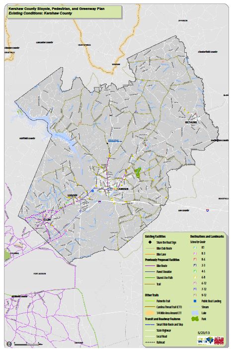
1 Sidewalk installation on Haile Street 1.6 Sidewalks with shared lane markings/bike lane
from Roberts Street to U.S. Hwy. 1 (2013 Kershaw County Bicycle/
Pedestrian/Greenway Master Plan)
Transit Projects
1 Right‐size SWRTA fleet and replace ‐‐‐
vehicles at end of useful life
Corridor/Project Feasibility Study Projects
1 U.S. Hwy. 1 (Wateree River to 7.30 US‐1 is the most heavily traveled corridor in
Woodward Airport) the SL region; several proposed projects along
the corridor are identified in the LRTP
2 I‐20 Exit 98 and Black River Road 4.20 Existing transportation network taxed by
increased development and traffic flow at I‐20
Exit 98; flow of vehicles at I‐20 exit ramps is
inconsistent; safety concerns on commercial
access along the U.S. Hwy. 521 exit corridor
3 Black River Road from U.S. Hwy. 521 to 2.00
Cleveland School Road
6 S.C. Hwy 97 (Camden to Lake Wateree) 8.20
9 U.S. Hwy. 601 (U.S. Hwy 1 to Richland 7.40
County line)
Source: SLRCOG LRTP, April 2017
Comprehensive Plan 2017-2027 yTransportation Element 8-17
The SLRCOG Transportation Improvement Program (TIP) is the agreed‐upon multi‐year list of
specific projects for which federal funds are anticipated. Required by federal and state law, the
TIP translates recommendations of the Long Range Transportation Plan into a short‐term
program of prioritized, tangible transportation improvements for the Santee Lynches region.
The TIP outlines the planning objectives, priority status, and funding sources for all projects
scheduled for construction over a five‐year period. Projects included in the TIP must be
financially constrained, meaning that the amount of funding programmed must not exceed the
amount of funding estimated to be available. The projects proposed by the TIP for each COG or
Metropolitan Planning Organization (MPO) are evaluated and incorporated into the Statewide
TIP by the SCDOT Commission. The 2017‐2022 TIP for the Santee Lynches region was adopted in
January 2017. Kershaw County projects included in the TIP are listed in Table 8‐8. Project
descriptions reflect SCDOT highway system categories: interstate, non‐interstate, non‐
interstate national highway system (NHS), non‐NHS primary (U.S. highways and S.C. designated
routes), federal aid (FA), and non‐FA secondary highways.
Table 8‐8. SLRCOG 2017‐2022 TIP Kershaw County Projects
Project Description Budgeted Funds and Status by Fiscal Year
System Upgrade ‐ Guideshare
Camden Truck Route, Segment 3 $9,250,000 in FY 2017 for construction
Intersection Improvements
U.S. Hwy. 521 at Century Blvd. $750,000 in FY 2017 for construction
Pavement Preservation
Federal Aid (FA) Secondary $347,000 in FY 2017, 2018, 2019, 2020, 2021 and 2022 for
construction
Non‐Interstate National Highway $457,000 in FY2017; $284,000 in 2018; $303,000 in 2019, $355,000
System (NHS) in 2020, $356,000 in 2021, $401,000 in 2022 for construction
Non‐NHS Primary $597,000 in FY 2017, $427,000 in 2018, $456,000 in 2019, $565,000
in 2020, $536,000 in 2021, $604,000 in 2022 for construction
Pavement Rehabilitation
FA Secondary $987,000 in FY 2017, 2018, 2019, 2020, 2021 and 2022 for
construction
Non‐Interstate NHS $941,000 in FY 2017 for construction
Non‐NHS Primary $701,000 in FY 2017; $501,000 in 2018; $535,000 in 2019; $628,000
in 2020; $629,000 in 2021; $709,000 in 2022 for construction
Bridge Projects
I‐20 east bound and west bound $3,549,000 in FY 2018 for planning & engineering
over Wateree Swamp Overflow
and Wateree River
U.S. Hwy. 1 at S.C.L. Railroad $50,000 in FY 2017 for right‐of‐way acquisition
$5,880,000 in FY 2020 for construction
U.S. Hwy. 521 over old railroad $50,000 in FY 2018 for right‐of‐way acquisition
bed $800,000 in FY 2020 for construction
U.S. Hwy. 521 over Big Pine Tree $1,578,000 in FY 2017 for planning; $113,000 in FY 2019 for right‐of‐
Creek bridge replacement way acquisition; $7,133,000 in FY 2020 for construction
Comprehensive Plan 2017-2027 yTransportation Element 8-18
Table 8‐8. SLRCOG 2017‐2022 TIP Kershaw County Projects, Continued
Project Description Budgeted Funds and Status by Fiscal Year
Transit
Kershaw County COA/FTA Vehicle $59,000 in FY 2017 for transit vehicle acquisition
Replacement ‐ enhanced rural
senior mobility
Source: SLRCOG 2017‐2022 Transportation Improvement Program, 2017
The most recent SLRCOG Rural Planning Work Program for FY 2015‐2017 (RPWP) was adopted
in August 2015 and describes the various tasks to be performed in Fiscal Years 2015‐2016 and
2016‐2017 by objective to develop, administer, and carry out associated transportation
planning functions. Program areas include general administration, geographic information
systems (mapping) support, freight and rail planning, general transportation related projects,
public transit, livability initiatives, accessible transportation alternatives, and research.
Individual projects listed in the TIP are included under these general program areas, with
budgeted funds listed by resource including SCDOT, other State resources, and local allocations.
Budget and resources are provided for the entire region rather than specified by individual
counties. The total budget for the 2015‐2017 RWTP is $106,250, of which $85,000 is expected
to be provided by the SCDOT and $21,250 by local match funding.
b. COATS Transportation Planning
As the transportation MPO for the Central Midlands region, the CMCOG is responsible for the
development of a multi‐modal Long Range Transportation Plan (LRTP). The CMCOG Board
serves as a forum for cooperative decision‐making on issues of regional significance, including
transportation. The transportation planning process is conducted under the oversight of the
Transportation Subcommittee, which is an ongoing forum for policy development and adoption
related to urban transportation planning, programming and operation. A Technical Committee
serves as an advisory group to the Transportation Subcommittee and provides technical
expertise related to development of urban transportation plans and programs.
The LRTP is the MPO’s primary transportation planning policy document and serves as the
comprehensive plan for transportation investment to support the safe and efficient movement
of people and goods within the Columbia urbanized area through the plan horizon year of 2040.
In accordance with Federal planning regulations, the 2040 LRTP reflects the latest available land
use, population and employment, travel and economic activity assumptions. It identifies long
range transportation goals and specific long‐ and short‐range investment strategies across all
modes of transportation to support meeting those goals. The Plan is fiscally constrained, and
supports regional land use and economic development policies and plans.
The LRTP addresses a number of recommended improvements to transportation facilities
including bridges, intersections, safety measures, maintenance and resurfacing, signalization,
and highways. The current recommended improvements program was developed in 2015. The
2040 LRTP for the Central Midlands region identified three widening projects for road segments
Comprehensive Plan 2017-2027 yTransportation Element 8-19
in Kershaw County (Table 8‐9). Funding has been identified for one of these projects – the
widening of U.S. Highway 1 from Steven Campbell Road to Session Road. This project is ranked
13th among all road widening projects in the region. Two additional road widening projects
were included in the LRTP aspirations list for road widening projects indicating that a need for
each project has been identified, but funding has not yet been secured. Funding has been
secured for three intersection improvement projects in Kershaw County, with rankings of 18, 21
and 31. Seven additional projects were included in the aspirations list for intersection
improvement projects. A new SLRCOG 2045 LRTP will be developed in 2018‐2019, with
anticipated adoption in June 2019.
Table 8‐9. COATS 2035 Prioritized LRTP List ‐ Kershaw County Projects
COATS Length
Rank Route Name (miles) Purpose and Need
Road Widening
13 U.S. Hwy. 1 (Steven Campbell 1.95 Improve traffic flow and safety, widen from
Road to Sessions Road) 2‐lane to 5‐lane roadway with paved median,
sidewalks and bike lanes
* U.S. Hwy. 1 (Sessions Road to 1.76 ‐‐‐
Watts Hill Road)
* White Pond Road 2.10 ‐‐‐
Intersection Improvements
18 Major route ‐ Church ‐‐‐ Traffic signal and/or possible re‐design
Street/Sessions Road,
Minor route – Smyrna Road
21 Major route ‐ Main Street, ‐‐‐ Left turn land on U.S. Hwy. 1
Minor route – Pine Street
31 Major route – Blaney Road, ‐‐‐ Traffic signal and/or possible re‐design
Minor route – Forest Drive/
Church Street/Dogwood Ave.
* On the Aspirations List, funding not secured
Source: CMCOG 2040 LRTP, August 2015
CMCOG completed the Elgin/Richland Sub‐area Plan in June 2010 for the 37 square mile area.
The plan was undertaken to address concerns about rising growth pressures in the study area
that have led to delays during peak hours. Modeling of future traffic conditions indicates that
the present road system will be inadequate to meet future traffic volume demands.
Additionally, while improvement to the functionality of the transportation network is
important, preservation and enhancement of the character of the community is also essential.
The Plan emphasizes and identifies key connections between transportation facilities and
existing and future land uses within the study area, and identifies and analyzes a range of
multimodal transportation alternatives and land use strategies for implementation. Guided by
input from the community and an advisory group comprised of municipal and county officials,
and local business leaders, CMCOG and SCDOT identified three guiding principles – balance
transportation improvements, plan for growth, and enhance community identity. The Sub‐area
Plan includes a number of recommendations that range from near term of two years or less to
Comprehensive Plan 2017-2027 yTransportation Element 8-20
long‐term with a ten to twenty year horizon. Actions include overlay zoning districts for
roadway corridors, intersection improvements, sidewalk additions, and improvements to
collector and arterial roads. More specific information on the sub‐area plan recommendations
can be found on the CMCOG website at: http://www.centralmidlands.org/pdf/ERNE%20Sub‐
Area%20Plan%20‐%20Final%20Report%20JUNE%202010.o.pdf.
The growth pressures of the West Wateree area of Kershaw County impact both transportation
and land use. In cooperation with Kershaw County, CMCOG completed the West Wateree
Transportation Study in March 2017. The multi‐modal transportation plan analyzes existing
transportation and land use concerns and conditions and provides recommendations based on
best practices, existing plans, and citizen input. The West Wateree study area covers
approximately 90 square miles in the southwestern area of Kershaw County, bounded by
Richland County to the west and including both the Town of Elgin and the Lugoff community.
The Study proposes long and near term road improvements to White Pond Road, U.S. Highway
1, and U.S. Highway 601; construction of a connector road and corresponding intersections
between U.S. Highway 601 and U.S. Highway 1; and the extension of Townlee Lane and the
addition of two connectors to facilitate economic development opportunities in the area. Full
details of the West Wateree Transportation Study can be found on the CMCOG website at:
http://centralmidlands.org/wp‐content/uploads/WWTP‐DRAFT‐Final‐Report‐29MAR17o.pdf.
The 2013‐2019 Transportation Improvement Program for the COATS region was adopted in
June 2013 and was most recently revised in September 2015. The TIP is a seven‐year program
of transportation capital projects accompanied by a seven‐year estimate of transit capital and
maintenance requirements. Although the TIP is usually approved triennially, the document may
be amended throughout the year. As of May 2017, there are no projects in Kershaw County
included in the 2013‐2019 TIP.
The COATS Unified Planning Work Program for FY 2015‐2017 (UPWP) was adopted in June 2015
and incorporates all transportation planning and directly supporting comprehensive planning
activities in the Columbia Metropolitan Area into a single document. As a mechanism for the
coordination of planning efforts by local, state, and regional agencies through the Columbia
Area Transportation Study, the UPWP identifies transportation planning activities that are to be
undertaken in the COATS study area in support of the goals, objectives, and actions established
in the 2035 LRTP. The four transportation goals of mobility, safety, environment, and facilities
were identified in the 2035 LRTP. Detailed objectives and action recommendations were also
identified for each goal area. The basis of the work program is focused on three broad areas:
Maintenance of a TIP that identifies projects and/or programs to receive various sources
of Federal funds covering highway, transit, and intermodal facilities and programs.
Maintenance and implementation of the LRTP that identifies priority transportation
system deficiencies and feasible/appropriate methods for addressing them in a fiscally
constrained environment.
Comprehensive Plan 2017-2027 yTransportation Element 8-21
Recognition of requirements established by the Federal Highway Administration
regarding the national planning priorities included in the 2016 FAST Act and National
Highway System legislation.
Tasks within the work program are organized into major categories including program
administration and support, short‐range transportation planning, long‐range transportation
planning, the TIP, and other activities. The total budget for the 2015‐2017 UPWP is
$2,584,719.50, of which $2,102,406 is projected to be provided through federal transportation
funding programs and $482,313.50 through local matching funds.
G. TRANSPORTATION FUNDING OPPORTUNITIES
Securing funding for needed transportation improvements is a top priority for South Carolina
communities. Amid tightening budgets at the local level as state and federal funding dwindles,
communities must seek alternative funding resources for much needed transportation projects
including road maintenance, paving, bridge repair, transit, sidewalks, greenbelts, connecting
trails, and mitigating traffic issues. The following sections discuss options available to local
governments in the Palmetto State.
1. SCDOT Transportation Alternative Program
Kershaw County and its municipalities are eligible for transportation enhancement funding
under the Transportation Alternative Program (TAP), formerly known as the Transportation
Enhancement Project Program, administered by SCDOT. TAP projects are federally‐funded,
community‐based projects that provide opportunities for local governments to pursue non‐
traditional transportation related activities such as pedestrian and bicycle facilities and
pedestrian streetscaping projects that might not otherwise be possible.
The TAP grant program provides funding on a reimbursement basis as part of the Federal‐aid
Highway Program funded through the FAST initiative. Costs are eligible for reimbursement only
after a project has been approved by the State Department of Transportation or a Metropolitan
Planning Organization and the FHWA division office. Eligible project areas authorized in FAST
for the Transportation Alternatives Program and the SCDOT Commission include pedestrian and
bicycle facilities and streetscaping projects. Eligible costs include preliminary and final
engineering work such as project development, environmental work, cost estimates,
construction plans, utility relocations, construction engineering, construction costs, and right‐
of‐way acquisition. TAP funds generally account for 80% of the total project cost, with local
governments required to provide a 20% match.
Available SCDOT program funding is provided in two population‐based divisions. Urbanized
areas with a population of more than 200,000, also known as a Transportation Management
Area (TMA), are eligible to compete for a share of nearly $3 million designated for urbanized
areas of the State. Areas of the State with a population greater than 5,000 other than urban
areas, known as Non‐Transportation Management Areas (NTMA), have a designated funding
Comprehensive Plan 2017-2027 yTransportation Element 8-22 pool of $1.83 million. The SCDOT has also designated $2.6 million for NTMAs with a population of less than 5,000. Kershaw County and the City of Camden, with populations of 62,342 and 6,931, respectively, are currently eligible in the second category, while the towns of Bethune and Elgin are eligible under the third category. Projects proposed by governmental bodies located in areas outside of Transportation Management Areas, such as Kershaw County and its municipalities, are considered under the statewide program, with distribution of funds determined by the SCDOT Commission. Such projects are limited to a maximum of $400,000. 2. Penny Sales Tax Section 4‐37‐30 of the South Carolina Code of Laws empowers counties to levy, by ordinance, a special sales and use tax as a source of revenue for highways, roads, streets, bridges, mass transit systems, greenbelts, and other transportation‐related facilities including, but not limited to, drainage relating to highways, roads, streets, bridges, and other transportation‐related projects. The tax must not exceed one percent, which equates to an additional penny on every dollar spent, and the tax must be approved by the public through a referendum. A number of South Carolina counties including Aiken, Berkeley, Charleston, Dorchester, Florence, Horry, Newberry, Orangeburg, Richland, Sumter, and York have implemented a penny sales tax to address capital projects and transportation needs. The key advantage to such a tax is that out‐ of‐county workers and residents and tourists who shop in the receiving county also contribute to the tax revenues through their purchases, helping to offset the costs of roads and other facilities. Under the legislation, counties that implement a one cent sales tax must share the proceeds with their municipalities using a formula based on population, must specify a period of time to collect a set amount of money for the identified projects (not to exceed 25 years or the length of payment for the specified projects), must appoint a commission to consider proposals for funding capital projects, and must formulate the referendum question for public vote. The commission must include three representatives appointed by the county council and three members appointed by the county’s municipalities, using population to determine the formula for municipal appointments. In addition to funding transportation facilities, revenue from the one cent tax may also be used for civic, educational, and cultural facilities; water and sewer projects; flood control and storm water projects; and dredging, dewatering, and constructing spoil sites. Kershaw County voters approved a one percent sales tax in 2016 to pay for school improvements in the Kershaw County School District. The tax will be levied for 15 years to pay for the $129 million bond referendum adopted in tandem with the sales tax. Funds from this tax will not be used for transportation facilities or projects. Comprehensive Plan 2017-2027 y
You can also read