Christmas Island A STEP BACK IN TIME - Self-Guided Trail
←
→
Page content transcription
If your browser does not render page correctly, please read the page content below
Christmas Island
1
                                                    2

                                                                             3

A STEP B A CK IN T IME
             Self-Guided Trail

christmas.net.au
                        S elf G uid ed Trai l – A S t ep B a c k in T im e   1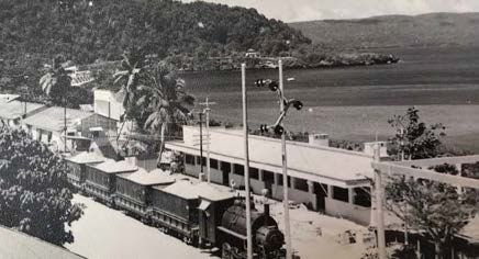
A S T E P B AC K IN TIME

    Flying Fish Cove 1877.

    On Christmas Day in 1643, Captain                Other self-guided trails focus on
    William Mynors of the East India                 the culture through The Spirit of
    Company vessel the Royal Mary                    Christmas Island and the mining
    named Christmas Island.                          history along The Old Railway.
                                                     These stories are interwoven,
    Christmas Island’s history is
                                                     overlap and together provide a
    short, tumultuous and unique.
                                                     glimpse into the rich history and
    The community has been shaped
                                                     culture of Christmas Island.
    by phosphate mining, different
    cultures, colonial and commercial                Grab a map from the Visitor Centre
    interests, war, industrial unrest and            and take a step back in time
    a natural environment like no other.             starting at Tai Jin House, Smith
                                                     Point. The drive is all on made
    For a small, remote island on
                                                     roads and should take 1-3 hours.
    the edge of the Indian Ocean,
                                                     The area between Smith Point and
    Christmas Island has been in
                                                     the Administrator’s Residence can
    the forefront of Australian politics;
                                                     be walked.
    yet remains relatively unknown
    and retains a harmonious
    multi-cultural community in an                            Grab a map from the
                                                              Visitor Centre.
    irreplaceable setting.
    It takes time for Christmas Island                        Approximate duration
    to reveal her secrets. So Take a Step                     1 – 3 hours.
    Back in Time on this self-guided
    trail and discover Christmas Island                       The drive is all on made roads.
    stories in the historical township.

2   Self Guided Trail – A S t ep B a ck i n T i me
1. SMITH POINT
Tai Jin House (locally known as Buck House) and surrounds provide a glimpse
of colonialism and war.
On 6 June 1888 Captain William May of the HMS Imperieuse formally claimed
Christmas Island for Great Britain. Christmas Island is valuable for its
phosphate, a soil nutrient, and its strategic location.
From 1901 until 1995 this area was occupied by the senior government official
on Christmas Island. The first being Lewis Clayton, the District Officer appointed
by the British Government through the Straits Settlement administration in
Singapore. His Chinese title was Tai Jin meaning ‘the Great Man’.
The present Tai Jin House was built around 1936, in a tropical, colonial
architecture style, replacing an earlier building. Above the main doorway is
a replica of the notice board of annexation left by Captain May in 1888. The
upper floor, a museum since 2008, was the residence and the ground floor an
office and courtroom. Life was isolated for the top official; not only due to his
role and the colonial attitudes of the time but it was difficult to physically leave
the area along the steep, narrow path to Flying Fish Cove. In good weather,
District Officers were able to walk down the cliffs to a row boat and go across
to Flying Fish Cove. Even as late as the 1970s this was a European enclave
unless people needed to service the house or were on official business.

  Flying Fish Cove and TSS Islander 1961.

                                              S elf G uid ed Trai l – A S t ep B a c k in T im e   3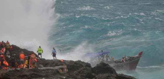
Holding Court.

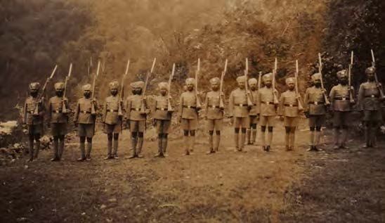
    World War Two came to Christmas                   Occupation was a particularly
    Island as the Japanese wanted                     difficult time for the Islanders from
    phosphate. The Island’s defences                  food shortages and forced labour. In
    included the six-inch naval gun                   December 1943 around 800 people
    manned by 25 Indian troops and five               were sent to Surabaya leaving
    English soldiers, the small barracks              about 500 people behind. After
    and, on the escarpment above                      the Japanese surrender in August
    the gun emplacement, a concrete                   1945 the remaining soldiers left and
    Command Post building.                            Christmas Island’s war was over. It
                                                      was time to rebuild.
    In early 1942, European and Indian
    women and children and non-                       After the war Christmas Island was
    essential staff were evacuated.                   again administered from Singapore.
    Submarine and aerial attacks and                  In 1948, the phosphate mine lease
    shelling from the sea in January                  was taken over by the Australian
    through to early March 1942                       and New Zealand governments
    indicated the Japanese were about to              who created the British Phosphate
    invade. The Indian troops garrisoned              Commission and an expansion
    on the island staged a mutiny,                    program started.
    murdered the British commanding
    officer and non-commissioned
    officers and imprisoned the
    remaining Europeans in the upper
    floor of Tai Jin House. The mutineers
    surrendered the Island on 31 March
    1942 to an occupying force of 850
    Japanese soldiers and construction
    staff. The Japanese quickly took over
    the fort, the phosphate plant and the
                                                       Children at ‘Buck House’.
    empty European houses.

4    Self Guided Trail – A S t ep B a ck i n T i me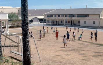
Sikh Police.

Things to do
• Wander through the museum at Tai            • Reflect at the Memorials to SIEV 221
    Jin House, the Gun Emplacement                and SIEV X near the traffic lights.
    and surrounding buildings.                •   Feel the power of Batu Gadja (the
•   Walk to the Command Post on the               Elephant Stone) on the cliff face near
    path towards Territory Day Park               the car park. It has been shaped by
    behind the barracks.                          limestone over the millennia.
•   Join in the ANZAC Day dawn
                                                     NEXT STOP
    commemorations on 25 April each
    year at the flag poles. People gather         Flying Fish Cove – Take the narrow
    at dawn to remember the fallen,               road towards Flying Fish Cove and
    the sacrifices and the futility of war.       the Kampong, watch out for the only
    Lest we forget.                               traffic lights on Christmas Island.

      HISTORICAL TALE
    The Unknown Sailor
    A body on a small Carley float (life- raft) was spotted near Flying Fish Cove on
    6 February 1942. The man’s body had no identification and was buried in the Old
    European cemetery after a brief service with a Sikh policeman playing the last
    post. The body has since been identified as being from the HMAS Sydney which
    sunk off the Western Australian coast on 19 November 1941 in a battle with the
    German raider Kormoran. The body was exhumed in 2006 and taken to Sydney in an
    unsuccessful attempt to identify him. His remains were reburied in the Geraldton
    War cemetery on 19 November 2008, 67 years after the sinking of the HMAS
    Sydney.

                                                  S elf G uid ed Trai l – A S t ep B a c k in T im e   5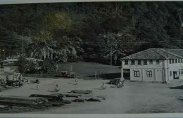
Loading phosphate 1961.

    2. FLYING FISH COVE
    For most of the year Flying Fish Cove             The first samples of phosphate were
    is a safe and natural harbour. At other           sent to Murray in 1895. In 1897 the
    times the sea is very rough. The port             Christmas Island Phosphate Company
    is the gateway to Christmas Island                was formed and continued operations
    for people, cargo and phosphate.                  until World War Two. The European
                                                      managers and overseers recruited
    Flying Fish Cove was the site of the
                                                      a workforce of mainly Chinese and
    first settlement in November 1888
                                                      Malay workers initially through the
    when the Clunies-Ross family, from
                                                      British colony of Singapore.
    the Cocos (Keeling) Islands asserted
    their claims to the Island’s resources.           Between 1900 and November 1918,
    They remained until mining                        1.5 million tons, or 2% of the world’s
    commenced in 1899. The family had                 phosphate production was shipped
    previously set up temporary camps to              through Flying Fish Cove. This was all
    collect timber, soil and food.                    dug by hand.
    The naturalist Dr John Murray,                    The well-used boat ramp was
    during the 1872-76 HMS Challenger                 constructed during the Japanese
    oceanographic expedition, postulated              occupation.
    that Christmas Island could be rich in
                                                      The cantilevers were built in 1963
    phosphate. Rock samples collected
                                                      and are still used to fill ships with
    during the 1887 HMS Flying Fish and
                                                      phosphate for export.
    the HMS Egeria expeditions showed
    this to be correct. This changed the              The Cove was the social hub, and
    Island’s future and left a few place              many long term residents remember
    names – Murray Road, Flying Fish                  the Satay Club and the Boat Club. The
    Cove and Egeria Point.                            remains of the Boat Club are visible
                                                      near the kayak racks.

6    Self Guided Trail – A S t ep B a ck i n T i me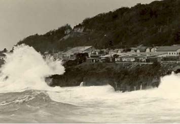
The Jetty was extended in 2013/14             Things to do
to enhance border security and safety
for offloading people from vessels.
                                              • Spend some time at Flying Fish
                                               Cove taking in the jetty, the water
The jetty is mainly used by small              and the facilities.
boats and for recreation.
                                                  NEXT STOP
                                               It’s a short drive along Jalan Pantai
                                               (Malay for Beach Road) to the
                                               Kampong. Park near the shops.

  The Boat Club.

3. KAMPONG
The residential area, known as the Kampong (Malay for village) is adjacent to
the port. This was the place of the first settlement, originally called Edinburgh
Settlement until New Settlement (now Settlement) commenced around 1928.
Malays were recruited from what is known today as Indonesia and Malaysia.
Most Malay men were employed by the port and marine services. The men
built koleks (canoes) from wood of the Gyrocarpus americanus (helicopter tree)
and fished the waters in the Cove to feed their families.

  The Kampong and koleks on the beach 1961.

                                               S elf G uid ed Trai l – A S t ep B a c k in T im e   7
Married Quarters 1950s.                           Kampong kids 1970s.

    The original Kampong houses were                  Things to do
    made of thatch and timber. By the
    1930s about half the men were
                                                      • Park at the shops and experience
                                                       the history in this residential area.
    married with families which helped
    them to establish roots and to be
    ‘islanders’.
    The Madrassa (Islamic School)
    and grocery store at the rear of the
    Kampong, are in residential buildings
    of the post-war era. Behind the
    Madrassa is a building relocated from
    the Cocos Padang in the 1970s.
    The Kampong was rebuilt to                         The Kampong 1969.
    Singapore Housing Development
    Board specification and completed in
    1970. These flats rehoused the Malay
    workers and their families who lived at
    the Kampong and the Cocos Padang.
    The current Mosque was built by the
    British Phosphate Commissioners to
    support the Malay community. The
    Malay Club, a former residence, is an              The Mosque 15 November 1938.
    important cultural organisation and
    place for meetings and gatherings.                    NEXT STOP
    The Kampong retains a village like                 Take the short, steep hill to the Post
    feel with the enclosed central area                Office and a large open space known
    surrounded by the Singapore style                  as the Post Office Padang (Malay for
    flats and is still the heart of the                open space).
    Malay community.

8    Self Guided Trail – A S t ep B a ck i n T i me
4. POST OFFICE PADANG AND
ADMINISTRATION BUILDING
In the 1900’s, the Post Office Padang (park) was a recreation area with a large
house nearby for a European manager, a Europeans only swimming pool and
on the slopes were vegetable gardens and a fledgling coffee plantation. The
police station, gaol and a Sikh temple were nearby.
The European Manager’s house was built high above the Padang in the early
1920s and was later converted into the European Club. The building was last
used as a social venue in the mid 2000s and then left to decay.
The Post Office is built where a wireless station once stood. Next to the Post
Office was a swimming pool, built in 1927. Initially this was for Europeans only.
By the 1980s it was open to all, marking a move away from earlier segregation.
The pool was an important venue for island kids until the new pool at the
Recreation Centre opened in 2005.
Across the road is a large building, built in 1926 as the main mine office. The
mine used to provide all the services to the Island. The building has played a
significant role in the life of Christmas Island also being a post office, welfare
office and a bank. It is now government offices.

  The Post Office Padang (park).

                                             S elf G uid ed Trai l – A S t ep B a c k in T im e   9
Things to do
• Reflect on the hardships of NEXT STOP
Japanese occupation in World War
A few metres along the road is the
Two at the plaque in the Post Office
Roundabout. Drive through to the
Padang.
Visitor Centre or safely pull up on the
• Discover Christmas Island stamps side of the road.
at the Post Office.
Swimming Pool 1952.
The original mine office. On the left is the wireless station and swimming pool.
INTERESTING FACT
The governance arrangements for the Territory of Christmas Island are complex.
On 1 October 1958 Christmas Island became a Territory of Australia but did not
automatically receive the same rights and laws which operated on the mainland.
Christmas Island is administered by the Australian Government based in Canberra,
around 5,000 km away. Residents vote in the Northern Territory electorate of
Lingiari, just under 3,000km away. Since 1992 West Australian laws apply. Prior
to this Singapore laws applied, however, the last Singapore law was cancelled as
late as 2001. The first Shire Council was elected in 1993, replacing the Christmas
Island Assembly and Services Corporation. The Shire provides a range of local
government services.
10 Self Guided Trail – A S t ep B a ck i n T i me5. THE ROUNDABOUT
This is arguably the most isolated roundabout in the world. All traffic between
the coastal terrace and the next plateau passes through this point. It makes it
an ideal place for the community blackboard, the original social media.
The series of two story units on the right just after the roundabout are known
as the Roundabout Flats. The flats were built in 1941 as the living quarters for
Asian clerks and accountants. Their size, location and layout shows aspects
of the class and racial social structures which were prevalent of the time when
compared with the housing provided to the Europeans.
During the Japanese occupation in World War Two (March 1942- August 1945)
European prisoners of war were temporarily housed in the Roundabout Flats.
After the war, the buildings were again used for Asian staff quarters until the
1970’s. Since the 1990s the buildings have been private homes.
The other buildings in this area were built by the mine.
Things to do
• Leave a comment on the blackboard.
• In the dry season it is possible to see the remains of a stone phosphate
hopper at the cliff just after the Roundabout Flats.
NEXT STOP
Staying on Gaze Rd along the coastal terrace, the next stop is the Visitor Centre,
just past the phosphate silos which are fed by the overhead conveyor belt.
S elf G uid ed Trai l – A S t ep B a c k in T im e 116. VISITOR CENTRE
Gaze Road, named after Alfred
Gaze and his son Harold
who both served as General
Managers of the British
Phosphate Commissioners,
has undergone many changes.
Having once been the centre
for services and utilities with a
thriving community, it is now a
laid-back commercial, tourism The Visitor Centre and surrounds.
and residential area.
The brightly decorated building has been the Visitor Centre since 1994.
Previously, it was a mandors’ (Chinese overseers) club, a Eurasian staff club
and a youth club. More notoriously it is near the site of the White House, the
Island brothel, where Japanese and Chinese prostitutes lived.
A Gospel Hall occupied the lookout below the Visitor Centre.
The small beach below, known as Isabel Beach is named after the wife of Sir
John Murray, the founding father of Christmas Island.
Across the road is the main supermarket. It was built by the mining company
as the Trade Store, on the same site was the Kongsi store run by the labour
Inside the trade store early 1970s.
12 Self Guided Trail – A S t ep B a ck i n T i mecontractor. Here, in December 1919 now the bakery. Further along is the
there was a riot by the coolies Chinese Literary Association (CLA)
against the Island’s Chinese Manager. built in the 1950s by the British
Two coolies were shot dead by the Phosphate Commissioners. The
Sikh police. CLA was formed at the end of World
War Two and has been important to
When the mine closed in 1987, the
maintain the Chinese culture and a
Trade Store was transferred to the
place for workers to meet.
Christmas Island Assembly and
Services Corporation (the predecessor
of the Shire) and then transferred to Things to do
private ownership in 1994. • Take a look inside the Visitor
Next to the supermarket are derelict Centre to see how the interior
buildings. The large double storied has been adapted, find out
building, was constructed for the the latest happenings and grab
Chinese clerks and mandors around some souvenirs.
1910. It is known as the Virgins’ • Walk to the lookout and Isabel
Castle as it was later used as the Beach.
quarters for single Asian women. • See if the small Chinese museum
The small roofless building was across the road from the CLA is
a privately owned residence on open and take a look inside.
the Island until the mid 1990s. It
was owned by the Chinese labour
contractor and shows the wealth
and power in controlling virtually all
aspects of the indentured labourers’
lives until the practice ceased in the
1930s. The labourers worked in harsh
conditions to pay off their debts.
From the beginning the majority of
Christmas Islanders were, and still
are, of Chinese origin.
In the car park was a butcher and
next to this was an open air cinema, The Virgins’ Castle 1930.
NEXT STOP
Along Gaze Rd, turn left onto the Gaze Road Service Rd to the Tea Gardens park
next to the Police Station.
S elf G uid ed Trai l – A S t ep B a c k in T im e 13Gaze Rd 1963.
7. THE TEA GARDENS
Gaze Rd towards the Tea Gardens when a better diet, including rice with
was traditionally the centre for the husks, was introduced.
Chinese community and the main
A railway line ran along Gaze Rd from
services area. Most of the current
the Cocos Padang. On both sides of
houses along Gaze Rd were built
the railway line were coolie quarters,
in the 1950s and are now private
each building capable of holding 16
residences or shops.
men. In the late 1930s until World
The first hospital was built along War Two, the Chinese gathered to
these cliffs in the 1900s and was socialise, eat, drink and gamble on
known as the Beri Beri Hospital. Life wooden tables under a corrugated
was difficult for the early inhabitants iron roof at the Tea Gardens, located
with long and hot work days, near the current fuel tanks.
unsanitary living conditions, poor
diet and inadequate water. Beri Beri,
a lack of thiamine (vitamin B1), was
a common illness across Asia and
caused over 600 deaths during 1900
to 1904 on Christmas Island. The
cause was not known at the time. The
Chinese workers believed their illness
was due to wind blowing up from
their feet into their body. The real 40 Houses and 20 Houses in 1951.
cause was a diet of polished (white) The Buildings were removed following
rice. The death rate was reduced the 1988 Cyclone.
14 Self Guided Trail – A S t ep B a ck i n T i meCinema was important for the community. The first small building on the
ocean side after the CLA was a store room for films. The second small building
was the projection room for an open air cinema. Under British law the pictures
started with the British National Anthem followed by movies in Malay, Chinese,
English or Hindi.
The foundations of the Asian swimming pool are still visible along the cliff
tops. The pool was destroyed in 1988 by a cyclone.
The Tea Gardens park is located on a former residential area known as the
40-houses. Many locals call this area the Police Padang due to the location
next to the Police Station.
The remnants of industry and the rail transport link between the base of the
incline and the wharf can be glimpsed but perhaps the most visible is the
concrete pad of the old power station on the other side of the road and behind
it the incline.
Things to do
• Peek inside the 1950s buildings at the shops at Temple Court.
• Look at the art in the Tea Gardens, and enjoy the sunset or a BBQ.
NEXT STOP
Continue along the Service Rd to the Barracks.
Asian Swimming Pool 1960s.
S elf G uid ed Trai l – A S t ep B a c k in T im e 158. THE BARRACKS
At the start of the Barracks precinct is the Police Station. Built in the late
1950s, it was originally the living quarters for single male teachers and other
government employees until converted to a Police Station in 1963.
The first contingent of Sikh Police arrived from Singapore with the first
European District Office in 1901. Police were recruited from Singapore until
the 1980s. They enforced Singapore laws and many lived in the neighbouring
Barracks.
The Barracks show the social status of the government employees in
comparison to European employees of the mining company. The Barracks
were partially destroyed in the 1988 cyclone and left derelict for around five
years. The government then offered them to people to repair and eventually to
purchase for shops and homes.
NEXT STOP
Things to do
Look across to the Cocos Padang.
• Wander through the Barracks shops.
The Barracks 1957.
16 Self Guided Trail – A S t ep B a ck i n T i me9. COCOS PADANG (previously Kampong
Cocos Baru – the new Cocos Village)
The Cocos Padang Lodge is the remains of the buildings which housed
workers, including those recruited from the Cocos (Keeling) Islands during
the 1950s and 1960s rebuilding program. The form of the Standard Asian
Labourers Barracks built by the British Phosphate Company is easy to see.
Sleeping and living areas at the front with a separate kitchen and ablutions
block at the rear connected by a covered breezeway.
In the late 1960s, when the British Phosphate Commissioners ended the labour
contract scheme and employed European tradesmen, many Cocos Malays and
other residents of this area were rehoused at the Kampong. The building then
became a Scout Hall.
After many years of
neglect the building
was renovated and
reopened as tourist
accommodation in
2014 retaining its
original character
and form.
The Cocos Padang
is at the base of the
Incline and was near
to the railway shunting
yard between 1915
and the mid 1950s.
Trains were loaded at
the incline and then
travelled to the port via
the Roundabout and
Settlement 1941.
behind the Kampong.
NEXT STOP
At the end of the Service Rd turn left onto Tampa View then right along the sea
front to see the Old Hospital Group.
S elf G uid ed Trai l – A S t ep B a c k in T im e 17SIEV 221 15 December 2010 (The Australian).
10. TAMPA VIEW
Christmas Island has been in the Island. The Australian government
international and national spotlight refused the Tampa entry and
due to the immigration detention deployed the military to board the
centre and associated policies but ship. After a lengthy standoff most
would rather be known for its vibrant asylum seekers were shipped to
community, rich history, many Nauru and held in detention, prior to
cultures and unique nature. eventual resettlement.
In August 2001 an international Since then Christmas Island has
diplomatic dispute brewed after received many people arriving by
the Norwegian Cargo ship Tampa boat to seek asylum. An immigration
rescued 438 Afghan asylum seekers detention centre was opened in
from a distressed fishing vessel in 2005 and has housed many asylum
international waters near Christmas seekers and others who have been
placed in immigration detention.
Tragedy struck in the early hours of
15 December 2010 when a small
asylum seeker boat known as SIEV
221 (Suspected Illegal Entry Vessel)
struck the cliffs at Tampa View in wild
seas. Many lives were lost, however,
42 people were rescued due to the
efforts of the Navy, emergency
The Tampa Christmas Island 2001.
services and the local community.
18 Self Guided Trail – A S t ep B a ck i n T i me11. THE OLD HOSPITAL GROUP
The buildings along this strip are part of the old hospital, which was run by the
British Phosphate Commissioners.
This complex consists of buildings erected between the 1930s and 1970. It is
an example of a hospital that grew and changed over time to provide facilities
to serve the small, isolated population. Facilities included wards, nurses
quarters, laboratory, x-ray and surgical theatres, morgue and dental clinic.
To have been born at the Old Hospital is a sense of pride amongst the older
Christmas Islanders.
The buildings were damaged in the 1988 cyclone and the hospital closed in
1995 after a new one opened at Phosphate Hill.
The heritage values are retained in the tourism and residential redevelopments
which date from the early 2000’s.
Doctor and Matron at the Old Hospital 1952.
NEXT STOP
Back on Gaze Rd turn left, then second left at Rocky Point Cres to the
Administrator’s Residence at 6 Rocky Point Cres.
S elf G uid ed Trai l – A S t ep B a c k in T im e 1912. THE ADMINISTRATOR’S RESIDENCE
Along Gaze Rd and the short loop social events, excursions and some
of Rocky Point Cres the variety of community work (teaching English)
houses used by Europeans employed kept the women entertained. But,
by the mine can be seen, including some never liked the isolation and
married quarters (MQ), visitor separation from their older children
quarters (VQ) and single quarters and homes back in England.
(SQ). Most were built in the 1950s but
An example of a pre-war bungalow
some date back to the 1930s. The
is the Administrator’s Residence,
houses and gardens were maintained
previously known MQ6 and before
by the mine until it closed in 1988.
that Bungalow Number 18. Built in
The European women on Christmas the 1930s by the Christmas Island
Island generally had a good and Phosphate Company this large
sheltered life during the period 1900 residence is indicative of the class,
to 1941. There were never more than racial and social structures of the
30 Europeans including ten women day. Asian domestic servants were
at any one time. Each family had housed in the quarters attached to
servants and an amah (nurse) to look the building while the Europeans
after the small children. Most shared occupied the main house. It was
the prejudices and assumptions of occupied by the Japanese during
racial superiority of the people of World War Two.
the British Empire. Dinner parties,
Single quarters being built in Settlement 1955.
20 Self Guided Trail – A S t ep B a ck i n T i meInside Bungalow 18 1937.
The building has evolved to show the changing NEXT STOP
lifestyles but has retained some of its original
form and status of its occupants. Back to the
roundabout, around the
It is home to the Administrator of the Territories of roundabout and take
Christmas Island and the Cocos (Keeling) Islands. Murray Rd up the hill to
This is an appointed position and is the most the Shire Offices at the
senior Australian government official on Christmas George Fam Centre.
Island. The position was created in 1968. Although
the role has evolved it continues the tradition of
government being represented by an appointed
Official Representative or District Officer.
Outside Bungalow 18 1937.
S elf G uid ed Trai l – A S t ep B a c k in T im e 21European School 1951.
13. THE GEORGE FAM CENTRE
The Shire of Christmas Island offices The European primary school
are housed in the George Fam students were taught separately
Centre, the former Asian School. The at the Tom Paterson building at
building was named in 1991 after the Settlement. The building was named
headmaster Fam Choo Beng (known for Tom Paterson (1923-1986) who
as George Fam) who served between was an Administrator. The building
1957 and 1970. was converted to a preschool for all
children in 1975.
In keeping with the times, schools
were segregated. The first school The Asian and European Schools
was opened in 1929 at Flying Fish merged in 1975 when teachers from
Cove (where the marine building now mainland Australia arrived and taught
sits) with four Malay students taught an Australian curriculum.
by a Malay Boatman. In 1930 the
In 2019, there were around 250
phosphate company built an English
students at the main campus of the
School with thirty Asian pupils under
Christmas Island District High
a Chinese teacher from the Singapore
School at Drumsite and the
Education Department. This was
kindergarten at the Tom Paterson
replaced by the Asian School in
Centre in Settlement. The school
1951 for 150 students with six
is well regarded in meeting the
classrooms, office and canteen.
needs of its students through
Lessons were in English based on
academic, vocational, social and
the Singapore curriculum. In 1961 the
cultural programs.
Christmas Island Asian School was
built at Drumsite.
22 Self Guided Trail – A S t ep B a ck i n T i meA Technical Training Centre opened in 1967 at Poon Saan.
Behind the water tank is the Incline. This was used to carry phosphate by a
cable gravity system down to the Settlement level, then shunted through
the coolie lines to storage and drying sheds above Isabel Beach before
despatch overseas. Prior to 1958 it was the main carriageway for people
between Drumsite and Settlement. Refer to the Old Railway Journey for
more information.
Things to do NEXT STOP
• Walk up the Incline to Back on Murray Rd continue up the hill to Poon
Silver City. Saan and stop opposite the Outdoor Cinema.
George Fam and students 1950s.
Students 1977.
S elf G uid ed Trai l – A S t ep B a c k in T im e 2314. POON SAAN
At the top of the hill is the residential area of Poon Saan. Poon Saan is a
Chinese expression for half hill.
At the top of the hill, the buildings on the right are the Singapore style Poon
Saan flats, developed as part of the Asian housing program. The program
started in 1968, under the supervision of the Singapore Housing Board, to
provide accommodation for the influx of mine workers from South-East Asia
and to relocate the families from South Point. The flats are now in private
ownership. The many rooftop dishes were added in 2016/2017 to enable
access to internet delivered by satellite.
Further along on the right, is the Christmas Island Outdoor Cinema. Since the
1930s movies have played a key role in island life. This cinema was built in the
1970s and still operates, even in the rain! The venue was a key meeting point
for the workers that eventually led to the formation of the Union of Christmas
Island Workers (UCIW) on 21 March 1975. The first General Secretary was
school teacher Michael Grimes (died November 2019), who later became the
Administrator between 1992 and 1994.
The UCIW sought to secure equity between the pay, and conditions of
Christmas Island Asian workers and those of workers on the Australian
mainland. Although Christmas Island had been part of Australia for almost
Chinese married staff quarters at Poon Saan early 1970s.
24 Self Guided Trail – A S t ep B a ck i n T i meChristmas Island Outdoor Cinema being built early 1970s.
20 years the conditions, pay and citizenship laws were not aligned. In 1979 the
passionate and energetic Gordon Bennet (1944-1991) was appointed as the
General Secretary of the UCIW. After many meetings, negotiations, promises
and effort it finally took a 13-day hunger strike by six members of the UCIW on
the grounds of Parliament House in Canberra for meaningful changes to begin.
A monument near the car park marks the original site of the Union Office. The
UCIW still exists with its premises at the Poon Saan shops and continues to
play a role in the fortunes and politics of Christmas Island.
Along Poon Saan Rd is the Poon Saan Club, built by the British Phosphate
Commissioners in the late 1960s as a gathering place for the Chinese
community. It remains an important social hub for meetings, playing traditional
Chinese games and for cultural events such as Chinese New Year and the
Hungry Ghost Festival.
Things to do
• Stop at the car park across the road from the Cinema at San Chye Loh and
take a look around.
NEXT STOP
Continue along Murray Rd to Drumsite. Take a left turn and a quick right turn onto
Lam Lok Loh.
S elf G uid ed Trai l – A S t ep B a c k in T im e 25The Jap House 1977.
15. DRUMSITE
Continuing along Murray Rd is Drumsite, named after the huge drum which
held the cable for the gravity-based Incline. The area was established in
conjunction with the construction of the Incline and railway systems between
1910 and 1920. It was a mixed residential settlement for skilled railway
workers and mechanics who worked under European supervisors.
Modern units for government workers were built in the early 2010s to
cater for the increased housing demand due to the immigration detention
centre activities.
Of note is the private residence on Lam Lok Loh, built in 1930. It was officially
known as Bungalow 702 but mostly it is called the ‘Jap House’. The Jap House
is an example of colonial Singapore-style architecture and is one of the few
pre-war buildings to survive in this area. The building symbolises the wartime
history of the island as it was taken over by the Japanese occupying forces in
1942 as a residence and radio station. Previously it was used by the Phosphate
Company to house European staff. In 1975 it was home to Michael Grimes
(first Secretary General of the UCIW) and family.
Most other buildings in this area date from the 1950s and 1960s and were
used by the mine workers and Asian Teachers. Most of the buildings are now
in private ownership.
NEXT STOP
Turn right onto Golden Bosun Rd, a short drive until right onto Nursery Rd next
to the National Park Headquarters and across the small bridge to the building
on the right.
26 Self Guided Trail – A S t ep B a ck i n T i me16. VLU2 RADIO STATION
Just after the small bridge on the
right, is the radio station VLU2 in a
former residence built by the British
Phosphate Commission. In 1986 the
TV and radio services were broadcast
from this building then known as the
Ham Shack. Community radio 6RCI
(named in the early 2000s) continues
to be broadcast from the building.
Technology has always been Broadcasting 1973.
important in reaching the outside
world. The wireless and radio stations
Singapore) the Singapore wireless
were originally in the Settlement area
station failed to answer calls, isolating
at the Post Office Padang. Between
Christmas Island. With the threat of
1935-1941 the wireless station had
occupation the Japanese beamed
three Asian operators and were in
radio messages to the Island warning
regular contact by morse code to
of reprisals for any act of sabotage.
Singapore and passing ships. People
To ensure contact with the outside
also had wireless sets tuned to the
world a small radio was hidden at
BBC to keep abreast of world news.
Grants Well. People risked their lives
During World War Two radio was a to listen to the news every week which
vital link to learn about world events. provided an important link to the
On 15 February 1942 (the fall of outside world during the occupation.
Wireless House at the Post Office Padang 1929.
S elf G uid ed Trai l – A S t ep B a c k in T im e 27By the 1980s the radio station had moved to Phosphate Hill and provided a
phone service to replace the telexes which were delivered across the Island.
People had to book the phone service in advance and were able to make short
calls. By the mid 1980s landlines were installed and a 3-digit phone number
used which related to the house number. This evolved into the standard (08)
9164 8xxx pattern used today. Mobile phones arrived in 2005 and were issued
as 043 921 5xxx with some of the numbers still in use.
Television was originally broadcast from the Cocos Padang using shows from
the Mining Television Network. By the 1990s four-week old ABC shows were
shown using VHS tapes. This was replaced by TV delivered by satellites.
NEXT STOP
Follow the road along to Territory Day Park.
Territory Day Celebrations 1970. Territory Day Celebrations 2018.
Territory Day Celebrations 2018.
28 Self Guided Trail – A S t ep B a ck i n T i meTerritory Day Celebrations 1970.
17. TERRITORY DAY PARK
Territory Day Park was named raised at a small ceremony at Tai
in 1988 as part of the thirty year Jin House and the Island became
celebrations of becoming a Territory. Australia’s ninth external Territory.
The park was covered in jungle until To compensate Singapore for lost
the 1960s when it was used for phosphate royalties a sum of £2.33
‘chooks’ (chickens). Youngsters who million (Malayan $20 million) was
lived nearby used to collect eggs for paid which has led to the mistaken
their families. Some would even put belief that Singapore sold Christmas
coconuts on the nearby phosphate Island to Australia.
conveyor belt, before it was covered,
All are welcome to join Christmas
just for fun!
Islanders on the first Monday of
At about the same time part of the October every year to celebrate
park was used by the mine as a Territory Day.
nursery to grow trees to rehabilitate
the mined areas. This work is Things to do
continued by the Christmas Island
National Park. • View Flying Fish Cove and Tai Jin
House.
After the war Christmas Island
continued to be part of the Colony of
• Take the short nature walk on the
left of the car park.
Singapore until 31 December 1957
when it became a separate Crown NEXT STOP
Colony. This enabled the phosphate
rich island to be retained in This is the end of the trail which has
‘British’ hands upon Singapore been a glimpse into the stories of
gaining independence. Christmas Island and how the people
and place have shaped this proud
On 1 October 1958, sovereignty was island community.
transferred, the Australian flag was
S elf G uid ed Trai l – A S t ep B a c k in T im e 29North West Point
West White Beach
Tom
’s R
idg
e
ches
a Bea
Rhod
Swell Lodge
Martin Point
3
Detention
PLEASE
Centre NORTH WE
ST POINT RD
Merrial Beach DALES RD
DALES WALKING TRACKS NORTH WEST POINT RD
No
1D
ale LB4
Darlling (No 4) DaleHugh’s No 2 Dale Jack’s Hill
349m
D
Hugh’s Dale
YR
Anderson (No 5)
RRA
Dale Waterfall
MU
EA
THE DALES ST
W EST
Sydneys (No 6) Dale Murray Hill BA
361m SE L IN E
No 7 D
Winifred Beach
ale
4
EACH TRAC
RED B K
WINIF CIRC
I VE
5
UIT T
DR
RACK
A
S MB
N RI
N
HU
TA
Douglas Point
Egeria Point Middle Point The Blowholes
Smithson Bight Indian Ocean
30 Self Guided Trail – A S t ep B a ck i n T i meNorth East Point
SE RD
COUR
GOLF
RD
MU GAZE
RD
RRA
GAZE
YR
D
The Grotto
ISH
ING F CO
Christmas Island 1 Phosphate Hill Cemetery
Tai Jin House Visitors Centre
VE
FLY
Gun Phosphate
Hill
Emplacement
Smith Point Golf Course
PHOSPHATE
Lookout
Territory Day Park Golf
RD
Recreation Centre
RRY
Course
HILL RD
QUA
Y RD
GOL
Christmas Island
MURRA
F CO
District High School
URS
ER
D
Irvine Hill
RD
D
LR
IRV
H
INE
HIL
LILY BEAC
IEW
HIL
ATE
LR
EV
D
SPH
H EADRIDG
h
O
eac
PH
are
tB 2 Christmas Island
RD
arg Airport
SE
M
UR O
GOLF C
LILY BEACH RD
RYAN HILL RD
Hanitch Hill
306m Christmas Island Resort
RD
RD
R
RAY
ATE
MUR
KW
Ethel Beach
LIN
PLA
TEA
UT
RAC
Ethel Beach
K Boat Ramp
Lily Beach
Ryan Hill
PROVIDE
JEDDA CAVE RD
Steep Point
Hosnie’s Spring
G
Margaret Knoll
Central AreaRANTS WELL RD
RD
INE
Workshop
SEL
Grants Well
BA
TH
OU
GRANTS WELL RD RD
S
CH
D
RTH
NR
BEA
NO
TIO
ETA
GR
STA
CH
JED
EAR
DA
Ross Hill Garden
RES
CAVE
RD
EA The Pink House
ST
W EST
BA
SEL
INE Stronach Hill
260m
Greta Beach
RD E
LIN
BAS E
TH
SOU
DOLLY B EACH
RTH
RD
NO
Ross Hill
LE S
319m
HO
L OW
RD
B
John D Point
Dolly Beach
RD E
ELIN
BAS
UTHO
TH S
NOR
OLD RAILWAY LINE
BOULDE
R TRAC
K
South Point INT
Railway Ruins PO D
TH LE R
SOU EMP
T
Produced by the Christmas Island Tourism Association | December 2019
South Point
S elf G uid ed Trai l – A S t ep B a c k in T im e 31Produced by the Christmas Island Tourism Association with support from the Australian
Government. 2019
Photos are from the Collection of the National Archives of Australia, Christmas Island Past and
Present and personal collections.
For more information: Other self-guided trails:
christmas.net.au Christmas Island Christmas Island
1 1
2 2
T H E S P IR IT OF 3
T H E OLD R A ILWAY
3
C H R IS T M A S IS L A N D
Self-Guided Trail
Self-Guided Trail
ChristmasIslandTourism
ChristmasIsland
christmas.net.au christmas.net.au
32 Self Guided Trail – A S t ep B a ck i n T i meYou can also read


