CITY CENTRES IN THE ERA OF SELF-DRIVING CARS: POSSIBILITIES FOR THE REDESIGN OF URBAN STREETSCAPES TO CREATE PEDESTRIAN-ORIENTED PUBLIC SPACES
←
→
Page content transcription
If your browser does not render page correctly, please read the page content below
CITY CENTRES IN THE ERA OF SELF-DRIVING CARS:
POSSIBILITIES FOR THE REDESIGN OF URBAN STREETSCAPES
TO CREATE PEDESTRIAN-ORIENTED PUBLIC SPACES

                SIU FUNG GEORGE LAU1 and JEROEN VAN AMEIJDE2
                1,2
                    The Chinese University of Hong Kong
                1
                  laugeorgelau@gmail.com 2 jeroen.vanameijde@cuhk.edu.hk

                Abstract. The forthcoming popularization of Self-driving Vehicles
                (SDVs) suggests a significant challenge in urban planning, as it enables
                new mobility patterns for urban citizens. While manufacturers have
                been developing visionary scenarios where cars become rentable mobile
                activity spaces, the impact of SDVs on the urban context is unclear.
                Through the analysis of the new social and technological functionalities
                developed by car manufacturers, and the projection of these functions
                into spatial scenarios of use within urban case study site, this paper
                explores the potential for the redesign of urban streetscapes to reclaim
                open spaces for pedestrian experiences and urban culture.

                Keywords.        High-density urbanism; Self-driving vehicles; Urban
                analytics.

1. Introduction
Since the advent of the Modernist doctrine, road infrastructure has dominated
urban planning, in many cases segregating community fabric by wide roads (Flint,
2009). Car companies play an influential role in promoting the use of private
vehicles, which undermines pedestrian’s interests (Schwantes, 2003). As the auto
industry plans to launch Self-driving Vehicles (SDVs) for the market by 2030, it is
foreseeable that our urban environment will be impacted by another phase in the
automotive revolution.
    Despite the development of SDVs keeps accelerating in recent years, there is
limited research on their impact to the urban environment. The main contributors
to speculations about the impact on urban environments by SDVs are governments
and car companies. An example is the ‘Blueprint for Autonomous Urbanism’,
an urban design guidebook published by a governmental organisation to suggest
pragmatic policies solutions to accommodate the arrival of SDVs (NACTO,
2017). This publication suggests a mild revision of existing street designs,
by widening street space for pedestrians and cycling, and reducing space for
vehicles. It assumes that large scale public transport, such as buses and trams,
will continue to play a significant role in future cities. However, the usage of
ride-sharing services with sedan size vehicles may dominate the majority of local
transportation (Fehr&Peers, 2018). The Blueprint explores to a small extent the

PROJECTIONS, Proceedings of the 26th International Conference of the Association for Computer-Aided
Architectural Design Research in Asia (CAADRIA) 2021, Volume 2, 609-618. © 2021 and published by the
Association for Computer-Aided Architectural Design Research in Asia (CAADRIA), Hong Kong.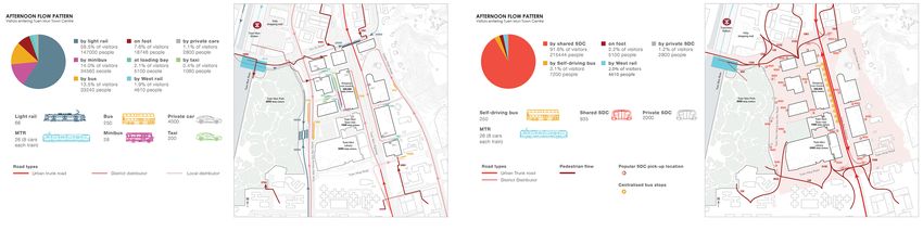
610                    S.F.G. LAU AND J. VAN AMEIJDE

potential of designing flexible and dynamic urban spaces, but largely promotes
the categorisation of different transport modes into lanes, while SDVs would not
need these. On the other hand, publications by car companies explore future usage
scenarios surrounding SDVs, visualising innovative uses of vehicles but without
exploring the impact on the urban environment. A project from Ford titled ‘The
City of Tomorrow’ with SDVs was subsequently criticised by urban planners as
it depicts future cities with Modernist urban planning elements such as elevated
walkways and wide road sections, resulting in low walkability (Speck, 2020).
    The possibilities of autonomous vehicle systems, as they have been announced
by car developers, point to the emergence of new urban mobility systems that
extend beyond the scope of the vehicles themselves, as they inform issues such
as ownership, management and spatial distribution across urban areas. The
technical features of self-driving vehicles, such as sensor-based responses, route
coordination in relation to other vehicles and real-time user inputs through
mobile applications, allow conceiving traffic management in urban areas as a
computationally controlled eco-system which can be adjusted dynamically to
satisfy collective interests. Their capacity to improve pedestrian safety, road
efficiency and function as an adaptive form of public transport, allows for the
radical rethinking of urban streetscapes and of the use of urban open spaces.
The possibilities for self-driving vehicles to function as mobile offices, shops,
restaurants or hotel rooms open up new scenarios for the distribution and mixing
of activity patterns of urban residents across urban centres and throughout the day.
    The aim of this study was to explore a possible future scenario for the reshaping
of urban open spaces, based on evidence of the new functionalities as they have
been presented by self-driving car manufacturers. It adopted a research-by-design
approach, using a case-study site in Tuen Mun New Town in Hong Kong to
explore processes of urban transformation, public space planning and a data-driven
distribution system for SDVs that prioritises human agency and collective social
engagement.

2. Self-driving Vehicles’ Opportunities Beyond Transportation
SDVs have advantages over conventional modes of transport, as they do not
require driver’s input and secure safe travelling thanks to controlling systems and
the real-time analysis of the route environment. The possibility of conducting
activities other than driving during travelling has been addressed by car designers
in various speculative visualisations and prototypes. For instance, Toyota
is developing its SDV system ‘E-palette’ with different modules like shops,
restaurants, offices and hotel rooms (Toyota Motor Corporation, 2018).
    Besides accommodating different interior activities, the overall anatomy of
self-driving vehicles is also likely to change. Israeli startup Ree revealed a flat
electric vehicle platform in 2019 that can be combined with different modules
(REE Automotive, 2019). These SDVs enable efficiency gains, allowing to swap
different types of cabins depending on demand, and for the separate charging of
platforms and batteries.
    These examples indicate that SDVs could enable productivity while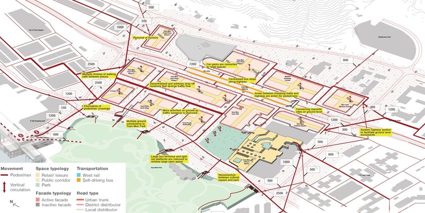
CITY CENTRES IN THE ERA OF SELF-DRIVING CARS:                           611
             POSSIBILITIES FOR THE REDESIGN OF URBAN
       STREETSCAPES TO CREATE PEDESTRIAN-ORIENTED PUBLIC
                              SPACES

transporting passengers, but could also be used as temporary stationary spaces
to introduce additional functions into open urban spaces.

3. Possibilities for Changes to Road Infrastructure
There is a range of technical innovations for controlling the movement of
SDVs, either individually in response to their environment or as a collective
system, by coordinating movements across multiple cars. Car companies have
been developing a ‘platoon’ mode of travelling, where SDVs can travel in
clusters at high speed to minimize road occupation and also wind resistance.
This functionality implies that road capacity and efficiency can be significantly
increased, resulting in narrower and fewer lanes for expressways and trunk roads
(Zhang, et al., 2020).
    SDVs‘ ability to detect obstacles with sensors and manoeuvre safely around
them, allows for the adoption of shared road systems. This principle allows
for the removing demarcations between vehicles and pedestrians at low-speed
sections, which benefits pedestrians’ freedom of walking. Originally introduced
by Hans Monderman in The Netherlands, well-known examples of the Shared
Space principle are Exhibition Road in London and New Road in Brighton.
Research on the traffic movement in both sites indicates that shared road systems
create the flexibility to give priority to different users groups in different traffic
conditions (Anvari, et al., 2016).
    According to researchers, the shift from private ownership to on-demand ride
services will reduce the demand for parking facilities between 67% and 90%
(Zhang, 2017). Meanwhile, charging facilities can be placed on the outskirts of
urban centres to avoid interference with public spaces. Due to their lower cost and
flexibility, on-demand ride services could also replace conventional transportation
such as minibuses and light rail. Subsequently, related infrastructure including
stations and stops can be removed, releasing a significant amount of urban space
for pedestrian-oriented planning.

4. Traffic Problems and Opportunities in Existing Urban Centres
To explore the changes to urban environments made possible by SDVs, a central
urban site in Tuen Mun New Town in Hong Kong is selected as a case study area.
The site represents ‘high-income, dense cities’ in Asia that are predicted to have
the highest level of adoption of self-driving vehicles by 2030 (McKinsey&Co,
2016).
    As almost 70% of the working population in Tuen Mun commute to work
in other districts (Census and Statistics Department, 2016), the quality and
experience of daily travel greatly impact people’s quality of life. Wide roads with
limited and difficult crossing, high footbridges, congestion and inefficient public
transport connections contribute to a negative travel experience. Barriers caused
by road infrastructure reduce public space usage by the community as a whole,
and people with limited mobility in particular.
    While Tuen Mun Highway experiences limited congestion during rush hour
periods, minor roads around the town centre are congested for most of the time.
612                        S.F.G. LAU AND J. VAN AMEIJDE

This is caused by a considerable amount of traffic flow to retail destinations,
where traffic lights and limited parking and drop-off locations cause delays to an
oversupply of private cars. This congestion does not only lengthen travel times
but also affects pedestrians through the added noise, pollution and safety risks.
    There is a wide range of literature advocating for well-designed streets. Jacobs
and Appleyard established the values of public spaces and streets as platforms
for ‘good city life’: “Liveability, identity and control, access to opportunity,
imagination and joy, authenticity and meaning, community and public life, urban
self-reliance, an environment for all” (Jacobs & Appleyard, 1987, p. 115). A
recent publication titled ‘Streets for People’ offers that streets should perform well
in both as a link and as a place. ‘Link’ refers to the directness of street connection,
which is expressed in time, based on an average walking speed. ‘Place’ refers to
a street that has activities that allow pedestrians to spend time, such as parks and
shops. This parameter is quantified by measuring the number of activities on street
sections (South Australian Active Living Coalition, 2012).
    To assess the impact of traffic infrastructure on the walking experience in Tuen
Mun, several routes from residential districts to popular places in Tuen Mun were
assessed according to the ‘Streets for People’ method. Most of the routes are not
performing well as both link and place, due to the many crossings or footbridges,
and sections that do not have any active street frontage programming. Traffic lights
at intersections cause waiting times in unpleasant conditions, and routes forced
along seven-meter-high footbridges do not contain any additional functions that
would animate the spaces (Figure 1).
    The urban planning of Tuen Mun prioritizes vehicles over pedestrians, where
wide roads and traffic lights contribute to the unpleasant walking experience. In
the subsequent research-by-design section, the potential of SDVs will be explored
to maintain traffic volumes yet offer improved urban environments for pedestrians.

      Figure 1. Street Quality Analysis, showing pleasant in orange and green colours and
                         unpleasant sections in blue and grey colours.

5. Tuen Mun Town Centre: An Epitome of Urban Problems
A 1 x 1 km area was chosen for a speculative redesign, which contains the
approximate area of Tuen Mun Town Centre. The site contains many of the
urban experience issues described above, including wide road sections and poor
ground-level walking experience. Walking routes within Tuen Mun Town Centre
are obstructed by ground traffic, as the ground level serves as a large transport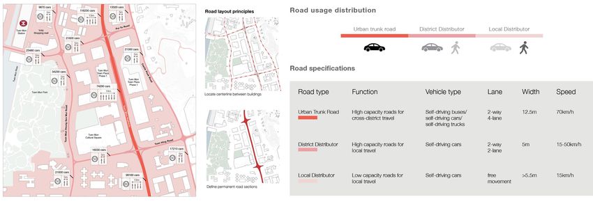
CITY CENTRES IN THE ERA OF SELF-DRIVING CARS:                             613
             POSSIBILITIES FOR THE REDESIGN OF URBAN
       STREETSCAPES TO CREATE PEDESTRIAN-ORIENTED PUBLIC
                              SPACES

hub for public transport, including minibuses and a local light rail system (Figure
2). As a result, the majority of the people flow is at the first upper floors, where
a public plaza and the main entrances to the town hall and library are accessible
via an elevated pedestrian level and several footbridges. This elevated system,
however, lacks the clarity of orientation, animation and freedom of route choice,
and a majority of it consists of privately owned public spaces controlled by retail
mall operators.

       Figure 2. Current pedestrian flow at ground level in Tuen Mun Town Centre.

6. Adaptive Traffic Management Based on Self-driving Vehicles
The large-scale adoption of SDVs offers the opportunity to redesign urban
streetscapes based on the cars‘ integrated technologies for improved safety, control
and management. This research-by-design study explores the possibility of
removing road infrastructure, pedestrian barriers and parking spaces, to create a
shared road space that prioritises pedestrians’ freedom to navigate and socialise.
Urban trunk roads such as Tuen Mun highway would continue to facilitate
high-speed traffic, and therefore should retain barriers for safety reasons. Local
distributor roads could be transformed to allow SDVs to plan routes freely at
low speed used the ‘Shared Space’ principle, without fixed lane demarcations of
pedestrian intersections.
    Within these shared spaces, the movement coordination of all cars in the area
would be controlled through a centralised computational system, allowing cars
cluster together to free up space and time intervals for pedestrians (Figure 3).
During peak hours when there are many vehicles, SDVs can be programmed to
travel at moderate speed along planned paths, giving priority to the vehicles and
instructing pedestrians to cross paths at specific locations or time intervals. During
off-peak hours when demand for using SDVs is less, the cars can be programmed
to prioritize pedestrian movements, slowing down or diverting routes to allow
pedestrians to walk uninterrupted (Figure 4).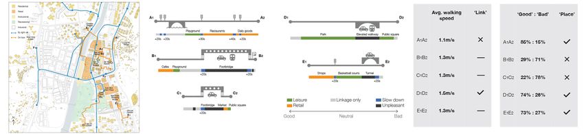
614                        S.F.G. LAU AND J. VAN AMEIJDE

      Figure 3. Road system in the future with shared roads (pink) as major public spaces.

  Figure 4. Types and volumes of different transport movements currently (left) and in the
                   predicted future system (right) during off-peak hours.

7. The Introduction of On-demand Mobile Functions in Shared Spaces
On the case study site, the introduction of SDVs and the associated restructuring
of transport systems would free up an open ground of approximately 10 hectares
for public use. In order to maximize the opportunities for social processes on this
common ground, there should be a system utilizing shared data to allocate space,
which would encourage spontaneous activities at different periods during the day,
and a new walking experience for people passing through the area.
     This projection points to an important aspect around the control of these new
types of dynamic spaces, that this should be managed as a public open space rather
than allowing it to be dominated by commercial interests. ‘Public space’ refers
to the ownership of the spaces, but also to assure that people from all layers of
society are welcome to use the space. ‘Open space’ in this context would refer
to the principle that the decisions about the materialisation of urban spaces are
open to input from all citizens. Following the principle of ‘The Right to the City’
(Lefebvre, 1968; Harvey, 2008), the amounts and functions of SDVs in urban
centres should be subject to governmental oversight for the purpose of enhancing
collective interests and the quality of urban spaces.
     A reference to support the idea of ‘common ground’ proposed in this case study
is the open structures explored by Archizoom. In the 1969 project ‘No-Stop City’,
an infinite grid of sheltered space is provided for people to choose freely where and
how they would like to inhabit the space. While basic facilities such as bathrooms
CITY CENTRES IN THE ERA OF SELF-DRIVING CARS: 615
POSSIBILITIES FOR THE REDESIGN OF URBAN
STREETSCAPES TO CREATE PEDESTRIAN-ORIENTED PUBLIC
SPACES
were provided, actions and activities were all determined by the users (Branzi,
2006). Similarly, the idea of common ground in this project is to aim for minimal
intervention on open space usage and let users decide and negotiate.
8. Dynamic Adaptation of Public Space
This research-by-design proposal reveals the opportunities of a large and flexible
public open space, keeping the area free of permanent fixtures to maximise the
potential of a dynamic configuration of activities enabled by SDVs (Figure 5).
Similar to current on-demand services such as Uber, functions can be allocated
based on real-time user input, using geolocation data and electronic payment
systems. Functions could be physically located near areas where there is a higher
number of (anticipated) requests, opening the configuration of the space up to a
democratised or market-driven system of dynamic demand and supply.
The project explores the possibility for a control system of SDVs that is not
just based on the number of vehicles allowed in a certain area perimeter, but that
is spatialised within the open spaces of the city. Using interactive maps accessible
to both providers and users of mobile services, a spatial negotiation can take place
based on proximity, cost, and attractiveness or quality of the service. To facilitate
temporary static functions enabled by SDVs such as food trucks, mobile meeting
rooms or grocery shops, public spaces can be subdivided into grid-based plots,
where each plot can document real-time and statistical data on current and past
uses. This data system, which is similar to current Google Maps functionalities,
should be accessible to all stakeholders to facilitate an equitable allocation of space
and services.
Figure 5. Future scenario of ground level pedestrian flows, following a comprehensive
redesign of traffic systems and public open spaces in the area.616 S.F.G. LAU AND J. VAN AMEIJDE
9. Case Study Scenario Simulations and Visualisations
To test how the choreographies of SDVs could result in more open space, dynamic
configurations of functions and improved social processes, several scenarios of
vehicle distributions and flows were modelled using animation software. This
exercise allowed to verify the capacity of the road spaces and the urban area as
a whole, modelling the same number of trips as in the current situation, based on
government data on road traffic volumes and public transport usage. Three periods
of a day were chosen to play out different scenarios for SDV movements, including
the morning rush hour, mid-afternoon, and evening periods.
For the morning is rush hour period, the large number of commuters travelling
between residential locations requires SDVs to be prioritised over pedestrians. The
shared road systems are switched to district distributor road protocol, organising
vehicles in compact clusters with 200 m distance gaps in between, to enable
20 seconds pedestrian crossing opportunities at one-minute intervals. Dynamic
signals assure pedestrian safety while the maximum speed is capped at 50 km/h.
It is assumed that a percentage of residents will prefer to use privately owned
SDVs, and the majority of commuters will use public transport for cross-district
commute, in the form of self-driving buses and the MTR. People living further
than 10 minutes walking distance from a regional transport station would use
shared self-driving shuttle vehicles, while the improved walking environment
invites local people to walk to stations. Along the main walking routes, catering
vehicles are stationed to provide breakfasts, informed by real-time data on people
concentrations and demand. Local companies can position mobile office vehicles
in the most convenient locations to bring collaborators together for meetings or
events, while other spaces in the common ground are reserved for social services
to serve different groups within the local population. Functions such as health and
exercise programmes, education and elderly support are enabled by specialised
vehicles distributed near target audiences (Figures 6.1, 6.2, 6.3).
During the afternoon, local pedestrians and street activities are prioritised, and
SDV movements in the area are limited in number and to a maximum speed of 15
km/h. This allows vehicles to dynamically avoid pedestrians who can walk freely
in the shared road spaces. Existing retail malls can be expanded with retail and
social activities at neighbouring public spaces, using stationary shopping vehicles
to configure outdoor market areas. As the current retail malls are organised
around elevated pedestrian corridors, these markets help activating the neglected
ground-level shopping experience. Similar to the morning scenario, part of the
public space is reserved for cultural programs and social services (Figures 6.4 &
6.5). At night, the public spaces are used for parked vehicles that function as
mobile homes or micro-apartments, to address the shortage and unaffordability of
housing in the local area (Figure 6.6).CITY CENTRES IN THE ERA OF SELF-DRIVING CARS: 617
POSSIBILITIES FOR THE REDESIGN OF URBAN
STREETSCAPES TO CREATE PEDESTRIAN-ORIENTED PUBLIC
SPACES
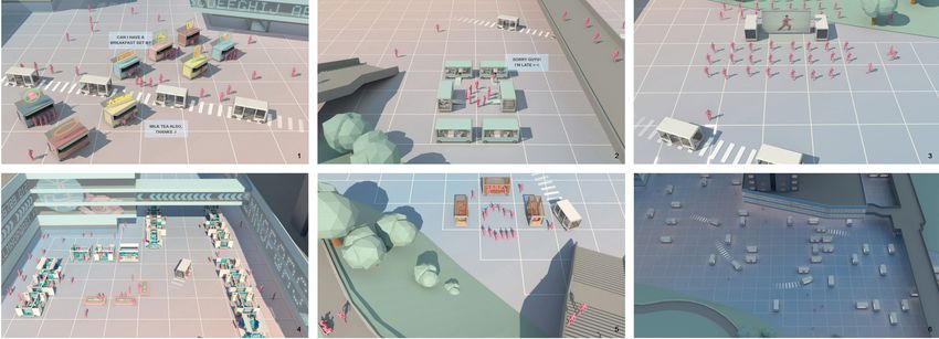
Figure 6. 1)SDVs with food truck modules arranged for commuter pedestrian flows. 2)Mobile
workspaces cluster for company employees. 3)Morning exercise area for elderly residents.
4)Temporary market arrangement with additional seating to activate public spaces outside the
existing retail mall. 5)Street performance surrounded by seating provided in parked vehicles.
6)SDVs stationed as additional micro-apartments to alleviate the housing shortage in the area.
10. Conclusions
The introduction of SDVs at large scale into urban centres offers several
opportunities as well as potential challenges. This paper argues that in order to
avoid the over-congestion of urban streetscapes by wide range of commercially
operating vehicles, the amount and spatial distribution of SDVs should be
controlled according to criteria that ensure public spaces that are pedestrian
oriented and inclusive. The technologies that ensure coordinated, safe and
responsive vehicle movements allow for the removal of traditional safety measures
that limit walkability such as pedestrian crossings, barriers or footbridges. The
increase in road use efficiency and the reduced need for parking allows for a
reduction in road space, freeing up vital space for better quality pedestrian spaces.
Shared space principles in low-speed traffic areas can be managed to prioritise
pedestrians during most periods of the day, while platooning protocols during
rush hour periods can still allow for opportunities for same-level crossing, which
increases the walkability of urban centres.
The additional functions of SDVs allow for the merging of travel and
productivity time for commuters, and also for choreography of temporary spaces
stationed around urban space to serve pedestrians. This ability suggests new
urban space experience and management, where the real-time negotiation between
supply and demand produces dynamic fluctuations of vehicle and people flows.
The case study design and simulation exercise in Tuen Mun Town Centre has
produced a vision on how future cities could operate, bringing changes to the
physical urban landscape as well as to the social and cultural facilities of the area.
Commercial operators are welcomed to bring additional vibrancy and customised
services to local residents, but it will be necessary to assure that a proportion of
the space and services is reserved for vulnerable groups.
While this study has aimed to speculate on the general organisational, spatial
and social consequences of introducing SDVs into urban centres, several different
types of studies could be undertaken to further develop the traffic and urban
planning concepts explored here. While many of the technical possibilities will618 S.F.G. LAU AND J. VAN AMEIJDE
likely be developed by the industry, we argue that urban designers and city
authorities have the urgent task to envision policies for the management of SDVs,
to maximise on the positive benefits that these can bring and to support the
expansion of vibrant, supportive and inclusive urban spaces.
References
“Streets for People: A Compendium for South Australian Practice” : 2012. Available from
South Australian Active Living Coalition (accessed 1st December 2020).
“Working Population by Sex, District Council District, Place of Work, Year and Working Age”
: 2016. Available from Census and Statistics Department (accessed 1st December 2020).
“Automotive revolution – perspective towards 2030” : 2016. Available from McKinsey
and Company (accessed 1st December
2020).
“Blueprint for Autonomous Urbanisms” : 2017. Available from National Association of
City Transportation Officials (accessed 1st December
2020).
“Toyota Launches New Mobility Ecosystem and Concept Vehicle at 2018 CES®” : 2018.
Available from Toyota Motor Corporation
(accessed 1st December 2020).
“The Annual Traffic Census 2018” : 2019. Available from Transport Department (accessed 1st December 2020).
“What are TNCs Share of VMT?” : 2019. Available from Fehr and Peers (accessed 1st December 2020).
“Ree Cooperates with Hino Motors to Showcase New Flatformer Concept Vehicle at the 46th
Tokyo Motor Show” : 2019. Available from REE Automotive (accessed 1st December 2020).
Anvari, B., Bell, M.G.H., Angeloudis, P. and Ochieng, W.Y.: 2016, Calibration and Validation
of a Shared Space Model: Case Study, Transportation Research Record, 2588, 43-52.
Branzi, A.: 2006, No-Stop City, Hyx.
Flint, A.: 2009, Wrestling with Moses: How Jane Jacobs Took On New York’s Master Builder
and Transformed the American City, Random House Trade.
Harvey, D.: 2008, The Right to the City, New Left Review, 53, 23-40.
Jacobs, A. and Appleyard, D.: 1987, Toward an Urban Design Manifesto, Journal of the
American Planning Association, 53, 112-120.
Lefebvre, H. 1996, Writings on Cities, in E. Kofman and E. Lebas (eds.), The Right to the City,
Blackwell, Cambridge, Massachusetts, 158.
Schwantes, C.A.: 2003, Going Places: Transportation Redefines the Twentieth-Century West,
Indiana University Press.
Speck, J.: 2020, “Ten rules for cities about automated vehicles” . Available from (accessed 1st
December 2020).
Zhang, L., Chen, F., Ma, X. and Pan, X.: 2020, Fuel Economy in Truck Platooning: A Literature
Overview and Directions for Future Research, Journal of Advanced Transportation, 2020,
1-10.
Zheng, W.W.: 2017, The Interaction Between Land Use and Transportation in the Era of Shared
Autonomous Vehicles: A Simulation Model, Ph.D. Thesis, Georgia Institute of Technology.You can also read