City Council Hayward Regional Shoreline Adaptation Master Plan - February 16, 2021
←
→
Page content transcription
If your browser does not render page correctly, please read the page content below
City Council

    Hayward Regional Shoreline
      Adaptation Master Plan

          February 16, 2021
1
Hayward Area Shoreline Planning Agency (HASPA)

•   Established in 1970

•   Includes City of Hayward, Hayward Area
    Recreation & Park District, and East Bay
    Regional Park District

•   Purpose: To coordinate agency planning
    activities and adopt and carry out policies for
    the improvement of the Hayward Shoreline
    for future generations
Hayward Regional
  Shoreline Adaptation
      Master Plan

• A priority project identified in
  Strategic Roadmap

• General Plan Policy HAZ-4.3
  Shore Realignment Master Plan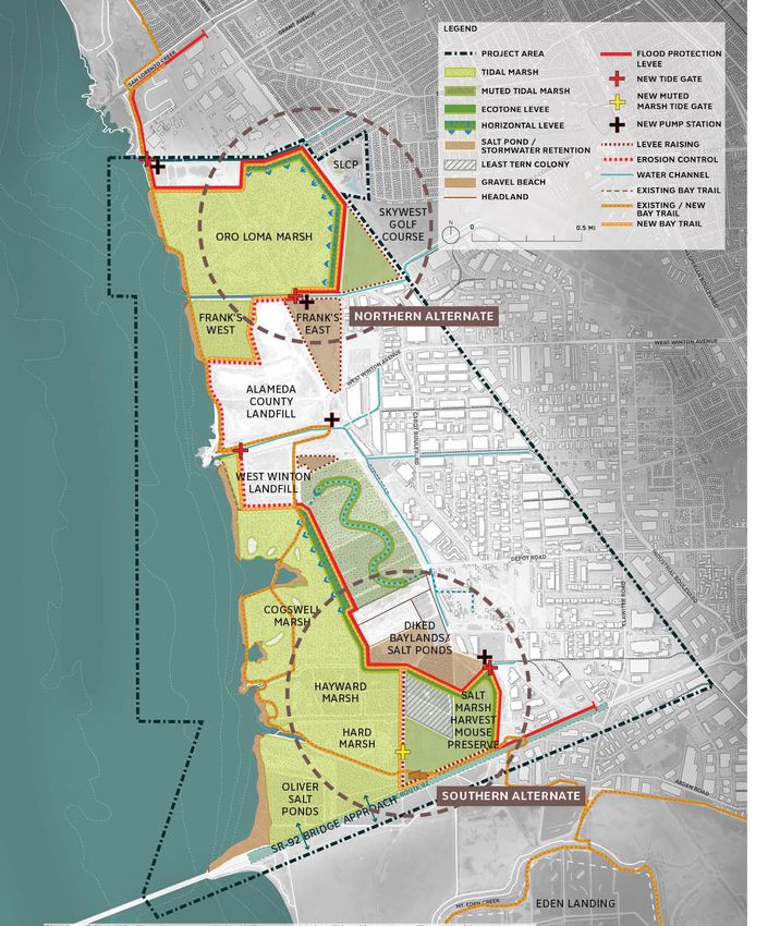
SCAPE LANDSCAPE ARCHITECTURE DPC

HAYWARD REGIONAL SHORELINE ADAPTATION MASTER PLAN
HAYWARD CITY COUNCIL

FEBRUARY 16,2021
AGENDA

• Master Plan Process
• Master Plan Document
• Implementation

HAYWARD SHORELINE ADAPTATION MASTER PLAN   SCAPE
February 16, 2021
                                                   2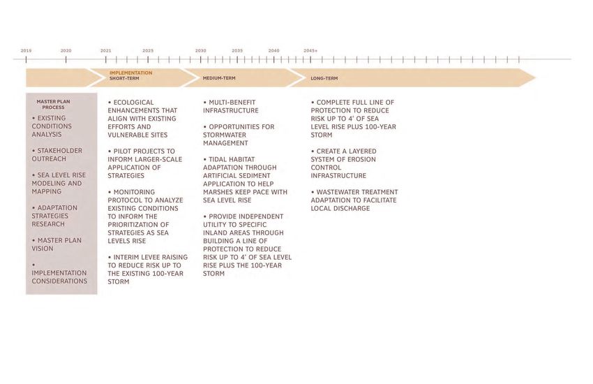
PROJECT SCHEDULE

                                           WE ARE HERE!

HAYWARD SHORELINE ADAPTATION MASTER PLAN           SCAPE
February 16, 2021
                                                           33
TASK 1: PROJECT INITIATION
Background Report Online Survey
SCAPE SCAPE
ARCADIS ARCADIS
CONVEY CONVEY
RE:FOCUS RE:FOCUS
SFEI SFEI
HAYWARD REGIONAL BAYLANDS TODAY
HAYWARD REGIONALSCAPE
A MOSAIC OF ECOLOGY AND INFRASTRUCTURE ARCADIS
SHORELINE MASTER PLAN The Hayward Regional Shoreline is a mosaic of bayland
environments that supports diverse wildlife habitats and
Diked baylands still exist within the project area,
and most are used to support various infrastructures SHORELINE MASTERCONVEY
PLAN
critical urban infrastructure. Formerly a zone of tidal
marshes and natural salt ponds, this stretch of shoreline
for the City of Hayward. Hayward Marsh, a 145-acre
managed pond system, receives treated wastewater RE:FOCUS
FOR THE HAYWARD AREA SHORELINE PLANNING
has undergone sequential transformations, resulting
in the current mix of restored tidal marshes, inactive
from Union Sanitary’s Wastewater Treatment Plant.
The system can also store and process excess waste SFEIPLANNING
FOR THE HAYWARD AREA SHORELINE
industrial salt ponds, filtration marshes, storage ponds, water during wet weather events, when the East Bay
AGENCY (HASPA) diked wetlands, landfills, solar fields, and biosolids
drying beds. Restored tidal marsh is a dominant
Dischargers Authority (EBDA) pipeline infrastructure is
at capacity. There is a unique combination of brackish
AGENCY (HASPA)
condition within the Hayward Regional Shoreline and freshwater conditions, and this area hosts federally
Master Plan Project Area. The following includes endangered species such as the California Least Tern
APPENDIX A:
short descriptions of each tidally influenced marsh. and the Western Snowy Plover. Hayward Marsh is
currently being considered for rehabilitation, as there
Oro Loma Marsh is a 364-acre fully tidal marsh
are many infrastructure and habitat quality concerns.
HAYWARD REGIONAL
restored in 1997. Once diked and degraded wetlands,
TASK 1 BACKGROUND
this area now supports robust habitats, including Above Hayward Marsh are former wastewater oxidation
ONLINE SURVEY SHORELINE MASTER PLAN
salt marsh vegetation, seasonal wetlands, high ponds currently used for water storage during wet
refugia mounds, and tidal flats. The west section weather events. Immediately south of the ponds and
of this marsh drains directly into the bay and the adjacent to biosolids drying fields, is a field of solar
east section drains to the bay via Sulpher Creek. panels. In the northern portion of the project area,
REPORT & EXISTING
additional solar panels and biosolid drying fields
AND STAKEHOLDER
Cogswell Marsh is 250 acres of formerly diked
adjoin the Oro Loma Wastewater Treatment Plant.
baylands fully restored to tidal marsh in 1980. A
reintroduction of bay tidal exchange facilitated Landfills are concentrated in the center of the
the development of a more robust tidal marsh and project area where tidal baylands were filled with
FOR THE HAYWARD AREA SHORELINE PLANNING
CONDITIONS ANALYSIS
supported the establishment of federally endangered unknown debris and waste. The City of Hayward
INTERVIEWS AGENCY (HASPA)
Salt Marsh Harvest Mouse and Ridgway’s Rail owned West Winton Landfill was capped and closed
populations. Constructed nesting mounds, excavated in 1974, and current monitoring protocols show
tidal channels, and invasive species management have no contamination to adjacent baylands. North
also contributed to the success of this ecosystem. of the city owned landfill is an Alameda County-
owned West Winton Landfill. Conversations with
COMMUNITY
Triangle Marsh is an 8-acre muted tidal marsh
SUBMITTED 06/14/2019 system restored in 1990. Robust marsh habitat
has developed within the site, but the West
experts led the Project Team to identify this area
of the project site most in need of further research
due to unknown infrastructure conditions.
SUBMITTED 06/14/2019
Winton Landfill backs onto the site and prevents
PART OF A JOINT POWERS AGREEMENT any further marsh expansion or migration. Inactive salt ponds and freshwater wetlands are PART OF A JOINT POWERS AGREEMENT
OF COH, HARD AND EBRPD OF COH, HARD AND EBRPD
OUTREACH PLAN
also distributed throughout the site and contribute
HARD Marsh is a 79-acre, fully tidal marsh comprised
to habitat diversity. Some areas, such as the Oliver
of mudflats and low marsh habitats. Restoration efforts
Salt Ponds, are historical resources that also
began in 1986, and currently the marsh does not
support federally endangered bird species.
contain any high ground or islands for wildlife refugia.
Salt Marsh Harvest Mouse Preserve is a 27-acre
site of muted tidal marsh managed by East Bay
Regional Park District (EBRPD) to maintain habitat
for the federally endangered Salt Marsh Harvest
Mouse. Currently, there is limited high ground within
the site, resulting in the need for combination gates
to manage water entering and exiting the system.
Fringe Marshes are established on the
outboard side of levees along the shoreline.
These areas support unique habitats such as
small beaches and rocky intertidal habitat.
Sources:
1. Adapting to Rising Tides, Hayward Resilience Study. January 2015.
2. Phillip Williams and Associates, LTD., Preliminary Study of the Effects of Sea
SUBMITTED 06/14/2019
Level Rise on the Resources of the Hayward Shoreline. March 2010.
PART OF A JOINT POWERS AGREEMENT
OF COH, HARD AND EBRPD
HAYWARD REGIONAL SHORELINE MASTER PLAN 25
Community Outreach Plan
HAYWARD SHORELINE ADAPTATION MASTER PLAN SCAPE
February 16, 2021
44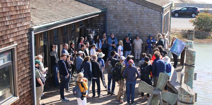
TASK 2: DATA COLLECTION AND SEA LEVEL RISE MAPPING
SLR Mapping Report

  SCAPE
  ARCADIS
  CONVEY
  RE:FOCUS
  SFEI

  HAYWARD REGIONAL TOPOGRAPHY AND BATHYMETRY                                                                                                                 Bathymetry
                                                                                                                                                             The bathymetry of the San Francisco Bay is typical of a sheltered tidal estuary system with broad shallow

  SHORELINE MASTER PLAN
                                            Topography                                                                                                       waters, and mudflats exposed at low tide� Soundings range from 0 feet-MLLW at the mudflats away from
                                            USGS conducted a Lidar campaign of the area in 2010 and generated a Digital Elevation Model (DEM)� The           the shoreline, to -0�5 feet-MLLW at an offshore distance of 1,000 feet� The bathymetry gets deeper closer
                                            vertical datum used is NAVD88� A number of modifications to this DEM were conducted by the San Francisco Bay     to the navigation channel, eastern edge of which is located about 5�8 miles from the shoreline�
                                            Conservation and Development Commission (BCDC) in 2015 to represent the changes to the shoreline between
                                            2010 and 2015� Moreover, the topography of the Hayward Marsh has been updated as part of this study to reflect

  FOR THE HAYWARD AREA SHORELINE PLANNING   the latest information collected by CLE Engineering in 2014, and provided by HASPA to the project team�

  AGENCY (HASPA)
  PART OF A JOINT POWERS AGREEMENT OF COH, HARD, AND
  EBRPD

  TASK 2
  DATA COLLECTION
  AND SEA LEVEL RISE
  MAPPING REPORT
  SUBMITTED 11/26/2019

                                                                                                                                                             Figure 3: Excerpt of Nautical Chart 18651 highlighting the study area� Soundings of 0�5 feet can be seen offshore as the intertidal
                                                                                                                                                             areas shown in green�
                                            Figure 2: DEM elevations in the project area�

                                            12                                                                                                 SCAPE         HAYWARD REGIONAL SHORELINE MASTER PLAN                                                                                          13

HAYWARD SHORELINE ADAPTATION MASTER PLAN                                                                                                                                                                                                                                                           SCAPE
February 16, 2021
                                                                                                                                                                                                                                                                                                           55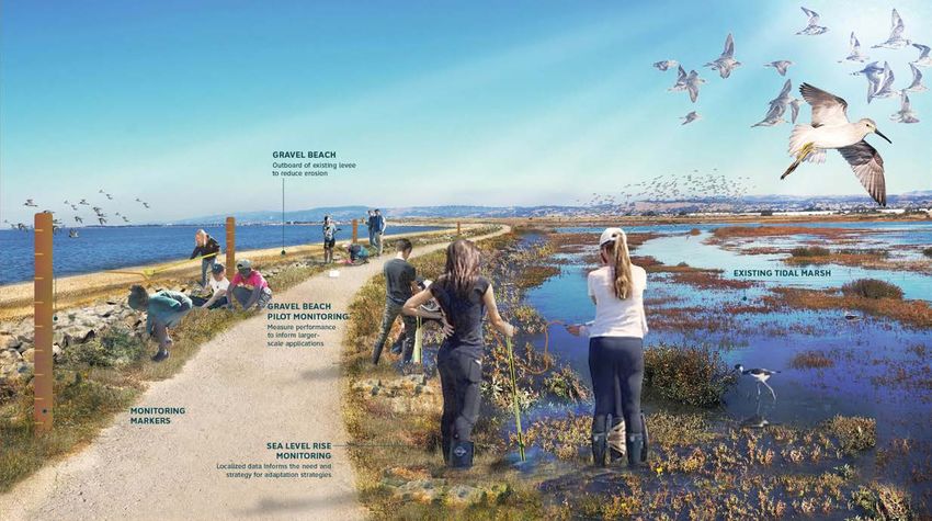
TASK 3: PUBLIC OUTREACH
                                                                                                                                                      Adaptation to virtual engagement due to COVID-19 pandemic (March 2020)

                               SEA LEVEL RISE MAPS
                               SLR + GROUNDWATER EMERGENCE
                                                                               NATURE-BASED STRATEGIES

                                                                               TIDAL MARSH RESTORATION   TIDAL MARSH & MUDFLAT    MARSH MIGRATION
                                                                                                             NOURISHMENT             PLANNING

                                                                                   FINE AND COARSE       POLDER MANAGEMENT       ECOTONE/HORIZONTAL
                                                                                    GRAIN BEACHES                                      LEVEE
                               2’ SLR                        4’ SLR   7’ SLR

HAYWARD SHORELINE ADAPTATION MASTER PLAN                                                                                                                                                                               SCAPE
February 16, 2021
                                                                                                                                                                                                                               6
TASK 3: PUBLIC OUTREACH

• ONLINE SURVEY
• 13 STAKEHOLDER MEETINGS
• 3 STAKEHOLDER WORKSHOPS
• PUBLIC SHORE TOUR
• 2 ONLINE PUBLIC FORUMS

HAYWARD SHORELINE ADAPTATION MASTER PLAN   SCAPE
February 16, 2021
                                                   7
TASK 4: PROJECT GOALS
• CREATE A RESILIENT SHORELINE FOR PEOPLE AND ECOLOGY
• ENHANCE THE SHORELINE ENVIRONMENT TO REDUCE RISK
TO CRITICAL INFRASTRUCTURE AND BUILT ASSETS
• BUILD SOCIAL RESILIENCE IN THE COMMUNITY
• BUILD CAPACITY FOR FUTURE GENERATIONS
TO ADAPT TO CLIMATE CHANGE
HAYWARD SHORELINE ADAPTATION MASTER PLAN SCAPE
February 16, 2021
88TASK 4: ADAPTATION RESPONSES
Adaptation Strategies Report
SCAPE
ARCADIS
CONVEY
RE:FOCUS
SFEI
HAYWARD REGIONAL PROJECT GOALS
SHORELINE MASTER PLAN
PROJECT STATEMENT: PROJECT GOALS
The Hayward Regional Shoreline Master Plan creates a framework for resilience to
prepare for sea level rise (SLR), groundwater intrusion, and storm surge� The Master Create a Resilient Shoreline Environment for People and Ecology
FOR THE HAYWARD AREA SHORELINE PLANNING Plan is being managed by the Hayward Area Shoreline Planning Agency (HASPA),
a joint power authority including the City of Hayward, Hayward Area Recreation
• Enhance the shoreline’s ecological value and adapt to sea level rise
AGENCY (HASPA) and
PART OF A JOINT POWERS AGREEMENT OF COH, HARD ANDPark District (HARD), and East Bay Regional Park District (EBRPD)�
EBRPD • Enhance recreational opportunities and adapt to climate change
• Create a management framework for adapting to sea level rise over time
The Hayward Regional Shoreline Master Plan project area is bounded on the north by • Provide refuge to help endangered shoreline species to adapt climate change
the Bockman Channel (also called the Bockman Canal) and extends approximately 3�25
miles south to the State Route 92 San Mateo Bridge approach� The extent of the project
area into the Bay was defined by the outermost limit of the Hayward Area Shoreline Enhance the Shoreline Environment to Reduce Risk
Planning Agency Jurisdictional boundary, and the inland extent of the project area are to Critical Infrastructure and Built Assets
drawn at the rail corridor� In total, the project area covers six square miles of various
FINE AND COARSE GRAIN BEACHES
• Align with and enhance existing management and capital improvement plans
land uses, including open space, urban infrastructure, industrial, and residential�
• Reduce risk to regional critical utilities from sea level rise,
groundwater intrusion, and flood events Option 1: Beaches in front of Landfills
TASK 4 The project area supports ecological bayland resources, hosts recreational opportunities
along the San Francisco Bay Trail, and facilitates educational programming for adjacent
residential neighborhoods and businesses at the Hayward Shoreline Interpretive Center�
• Reduce risk to transportation infrastructure from sea level
rise, groundwater intrusion, and flood events
GOAL / OBJECTIVE
GOALS AND POLICIES MEMO The shoreline is also home to critical urban infrastructure, including wastewater treatment
plants, the San Mateo-Hayward Bridge approach (State Route 92), and landfills� The
Master Plan will develop various multi-benefit strategies for the shoreline, its existing
• Reduce risk to agency assets such as the San Francisco
Bay Trail and marsh restoration project(s)
Reduce the risk of erosion to the two landfills and
ADAPTATION STRATEGIES REPORT infrastructure, and the surrounding natural habitat� The Master Plan will consider multiple
planning time horizons and sea level rise scenarios� Additionally, it will consider a range
Build Social Resilience in the Community enhance shoreline ecology with gravel nesting habitat.
of adaptation strategies that can evolve and respond over time to changing sea levels� • Promote social equity, environmental justice, and public health
FRANK’S WEST BUFFERS LANDFILL
The shoreline master plan encompasses four goals� • DESCRIPTION
Preserve the local economy and increase resilience to climate change
• • Gravel beaches in front of Bay shoreline structures in front
Prevent the disruption of key community services
SUBMITTED 02/21/2020 of Alameda County and West Winton Landfills
ALAMEDA COUNTY
Build Capacity for Future Generations to Adapt to climate change LANDFILL
• Build organizational and community capacity
• PROS
Provide a place for education, interpretation and understanding
of the shoreline and climate change • Reduce erosion to landfill edges WEST WINTON
LANDFILL
• Foster stewardship of the shoreline’s cultural and ecological resources TRIANGLE MARSH BUFFERS LANDFILL
• Reduce levee/berm maintenance adjacent to landfills
GROIN OR HEADLAND
• Could enhance shorebird and beach habitat
CONS
• May require artificial replenishment
• May require the installation of lateral7 containment structures
6 SCAPE HAYWARD REGIONAL SHORELINE MASTER PLAN
• Considered as fill under current regulations, which
might present permitting challenges
30 SCAPE
HAYWARD SHORELINE ADAPTATION MASTER PLAN SCAPE
February 16, 2021
99TASK 5: DRAFT MASTER PLAN - DESIGN ALTERNATIVES
Design Alternatives Report
SCAPE
ARCADIS
CONVEY
RE:FOCUS
SFEI
Tie back at 14.3'
#1: CLOSER TO THE BAY
FT
This alternative looks at an alignment for the line of protection
HAYWARD REGIONAL
that reduces risk for a larger portion of the shoreline with a more
conservative line of protection aligned closer to the Bay.
RA
SHORELINE MASTER PLAN
In the north end of the project area, the line of protection ties back along
the San Lorenzo Creek channel and wraps in front of Oro Loma WWTP to
D
protect it in place. It then cuts through the middle of Oro Loma Marsh and
Tie back at 14.3'
FOR THE HAYWARD
ties back to highAREA
ground at SHORELINE PLANNING
the two existing landfills. In the south, the
AGENCY
alignment then follows the western edge of the oxidation ponds and cuts
(HASPA) PART OF A JOINT POWERS AGREEMENT OF COH,
immediately south through Hayward and HARD Marsh. A HARD AND EBRPD
raised access road
#2: DOWN THE MIDDLE
Tie back
FT
along SR-92 ties back to high ground at the intersection of Clawiter Road. This alternative looks at an alignment that balances risk
This line of protection transforms existing tidal marsh into a muted system, reduction and ecological enhancement with a line of protection
that runs through the middle of the shoreline area.
RA
which will be harder to manage with rising sea levels and subsiding land.
The assumed planning elevation for the line of protection is 14.3’ NAVD88. The line of protection is pulled back in the north along the Union Pacific
The final design flood elevation will require further study and cost analysis. Rail Corridor and ties back to high ground at the San Lorenzo Creek
D
channel. It then ties back to high ground at the two existing landfills
and follows the western extent of the oxidation ponds to the south.
The alignment pulls back in the southern portion of the site and cuts Tie back at 14.3'
through the middle of the Salt MarshTieHarvest
back Mouse Preserve, then
ties back along a new levee along the access road for SR-92. #3: FURTHER INLAND
Tie back
FT
This alternative maintains a larger extent of tidal habitat, This alternative explores an alignment that is pulled the
while still reducing risk to critical infrastructure. furthest inland to maximize ecological restoration along the
TASK 5 shoreline and layer risk reduction infrastructure.
RA
The assumed planning elevation for the line of protection is 14.3’ NAVD88.
DRAFT DESIGN ALTERNATIVES The final design flood elevation will require further study and cost analysis. In the north, the line of protection is pulled back along the Union Pacific Rail
Corridor and ties back to high ground at the San Lorenzo Creek channel. It
D
then aligns to the eastern edge of Frank’s East and ties back to high ground
DRAFT SUBMITTED 03/31/2020 Tie back
at the two existing landfills. It is pulled to the east of the oxidation ponds and
FT
follows the eastern extent of the diked Baylands to the south before tying
back to high ground with a levee parallel to SR-92 along Clawiter Road.
Tie back at 14.3'
RA
This alternative prioritizes a larger extent of connected tidal habitat
that is Bayward of the line of protection and incorporates ecological
and risk reduction infrastructure along a wider extent of Baylands.
D
Tie back
SR-92 options: elevated in place, levees on The assumed planning elevation for the line of protection is 14.3’ NAVD88.
either side, or flood walls on either side
The final design flood elevation will require further study and cost analysis. Tie back
SCAPE
FT
34
Tie back at 14.3'
RA
D
SR-92 options: levees on either
side or flood walls on either side
60 SCAPE
FT
Tie back at 14.3'
RA
D
SR-92 option: rebuilt as a causeway
86 SCAPE
HAYWARD SHORELINE ADAPTATION MASTER PLAN SCAPE
February 16, 2021
10
10TASK 5: DRAFT MASTER SCAPE
ARCADIS
PLAN - REPORT CONVEY
RE:FOCUS
SFEI
• 246 page report
• Updates from board & agency review HAYWARD REGIONAL SHORELINE
comments ADAPTATION MASTER PLAN
• Implementation Considerations
FOR THE HAYWARD AREA SHORELINE PLANNING
• Phasing Plan
AGENCY (HASPA)
• Implementable Projects PART OF A JOINT POWERS AGREEMENT OF THE CITY OF HAYWARD, HAYWARD AREA RECREATION AND PARK
DISTRICT, AND EAST BAY REGIONAL PARK DISTRICT
HAYWARD REGIONAL SHORELINE MASTER PLAN
• Appendix A: Stakeholder &
Public Comments
• Appendix B: Cost Estimates
SUBMITTED 10/02/2020
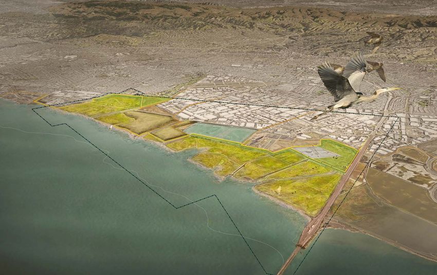
11PREFERRED ALTERNATIVE
HAYWARD SHORELINE ADAPTATION MASTER PLAN SCAPE
February 16, 2021
12FINAL MASTER PLAN - REPORT
SCAPE
ARCADIS
HAYWARD REGIONAL SHORELINE ADAPTATION MASTER PLAN CONVEY
RE:FOCUS
SFEI SCAPE
ARCADIS
HAYWARD REGIONAL SHORELINE ADAPTATION MASTER PLAN
CONVEY
RE:FOCUS
SFEI SCAPE
ARCADIS
HAYWARD REGIONAL SHORELINE CONVEY
ADAPTATION MASTER HAYWARD
PLAN REGIONAL SHORELINE
RE:FOCUS
SFEI
FOR THE HAYWARD AREA SHORELINE ADAPTATIONPLANNING MASTER PLAN
AGENCY (HASPA)
FOR THE HAYWARD AREA SHORELINE PLANNING
PART OF A JOINT POWERS AGREEMENT OF THE CITY OF HAYWARD, HAYWARD AREA RECREATION AND PARK
DISTRICT, AND EAST BAY REGIONAL PARK DISTRICT HAYWARD REGIONAL SHORELINE
AGENCY (HASPA)
ADAPTATION MASTER PLAN
HAYWARD REGIONAL SHORELINE MASTER PLAN
PART OF A JOINT POWERS AGREEMENT OF THE CITY OF HAYWARD, HAYWARD AREA RECREATION AND PARK
DISTRICT, AND EAST BAY REGIONAL PARK DISTRICT
HAYWARD REGIONAL SHORELINE MASTER PLAN
FOR THE HAYWARD AREA SHORELINE PLANNING
AGENCY (HASPA)
PART OF A JOINT POWERS AGREEMENT OF THE CITY OF HAYWARD, HAYWARD AREA RECREATION AND PARK
DISTRICT, AND EAST BAY REGIONAL PARK DISTRICT
HAYWARD REGIONAL SHORELINE MASTER PLAN
APPENDIX A
STAKEHOLDER AND PUBLIC
COMMENTS
SUBMITTED FEBRUARY 2021
APPENDIX B
COST ESTIMATE
SUBMITTED FEBRUARY 2021
SUBMITTED FEBRUARY 2021
HAYWARD SHORELINE ADAPTATION MASTER PLAN SCAPE
February 16, 2021
13
13PHASING STRATEGY
IMPLEMENTATION SCHEDULE
The Preferred Alternative is a long-term vision that
will be broken down into discrete projects that
will be phased over time. The projects identified
in the Phasing Plan are initial recommendations,
based on guidance from the Project Team. The
actual time frames for each project will need to be
flexible to align with design, permitting, funding,
and construction timelines on a project basis.
178 SCAPE HAYWARD REGIONAL SHORELINE ADAPTATION MASTER PLAN 179
14ORO LOMA INTERIM LEVEE SALT MARSH HARVEST MOUSE
PROJECT SUMMARY
•
•
Alameda County Flood Control District
San Francisco Bay Conservation and
PRESERVE INTERIM LEVEE
This project is intended to protect the Oro Lomo Development Commission • Alameda County Flood Control District
wastewater treatment plant and surrounding
• U.S. Army Corps of Engineers PROJECT SUMMARY • San Francisco Bay Conservation and
industrial district from flooding. It includes a flood
protection levee designed with meet today’s 1% This project is an interim levee designed to preserve Development Commission
annual chance flood with allowance for mid-range PERMITTING ASSESSMENT important endangered species habitat, as well as • U.S. Army Corps of Engineers
sea level rise, but with a foundation system that some of the critical infrastructure inland of the site
allows for the levee to be elevated in the future to Regulators are likely to be supportive of the intent of such as the Calpine / Russel City Energy Center
accommodate a higher elevation with sea level rise. this project, but the permitting process will be extensive. and the Hayward Wastewater Treatment Plant. It is PERMITTING ASSESSMENT
intended to protect against today’s 1% annual chance
The project also includes a new Bay Trail
flood and in the future will remain as a buffer from Regulators are likely to be supportive of the
spur extending inland from the shoreline and
more frequent storm events while the long-term intent of this project, but the permitting process
could provide a connection across the rail
Hayward Line of Protection project located further will be extensive. There will be special review
line to San Lorenzo Community Park. EASY HARD
inland will provide greater protection to inland critical regarding impacts on endangered species.
A new tide gate and pump station on Bockman infrastructure. The project includes levee raising west
Canal is also proposed, which would be of the SMHM preserve from the Solar Fields to the
planned in coordination with ACFCD pending COST ESTIMATE SE corner of the SMHM Preserve. It is planned to run
the results of their stormwater study. along the current levee alignments from the Hayward EASY HARD
High (>$20 M.)
Interpretive Center through HARD Marsh. A new spur
of the Bay Trail would be provided on top of the COST ESTIMATE
PROJECT SITE & OWNERSHIP TIME FRAME levee, which would connect back to the existing Bay
Trail along the northern levee of Hayward Marsh.
Medium ($5-$20 M.)
The site is located in the northern reach of the study Short Term
area. It is owned by the Oro Loma Sanitary District. PROJECT SITE & OWNERSHIP TIME FRAME
FUNDING & FINANCING • The project site is located in the southern reach of Short Term
the study area, slightly inland from the Bay. East
KEY STAKEHOLDERS RECOMMENDATIONS Bay Regional Parks District owns most of the site,
with some portions owned by the City of Hayward.
• HASPA • State of California Department of Water FUNDING & FINANCING
Resources Coastal Watershed Flood Risk
• City of Hayward Reduction RECOMMENDATIONS
https://www.grants.ca.gov/grants/coastal-
• Oro Lomo Sanitary District watershed-flood-risk-reduction-2/ KEY STAKEHOLDERS • FEMA Building Resilient Infrastructure and
Communities (BRIC)
• Bay Trail • HASPA https://www.fema.gov/grants/mitigation/
• FEMA Building Resilient Infrastructure and
Communities (BRIC) building-resilient-infrastructure-communities
• East Bay Regional Parks District • East Bay Regional Parks District
https://www.fema.gov/grants/mitigation/
building-resilient-infrastructure-communities • CA Department of Fish and Wildlife Endangered
• City of Hayward Species Conservation and Recovery Grant
Program
• Hayward Area Recreation and Park District https://wildlife.ca.gov/Grants/Endangered-Species
198 SCAPE HAYWARD REGIONAL SHORELINE ADAPTATION MASTER PLAN 199
15IMPLEMENTATION
HAYWARD SHORELINE ADAPTATION MASTER PLAN SCAPE
February 16, 2021
18
18THANK YOU!
You can also read