City of Social Circle Comprehensive Plan - Developed by the City of Social Circle - Madison, GA
←
→
Page content transcription
If your browser does not render page correctly, please read the page content below

City of Social Circle Comprehensive Plan
2017 Update

                                   Developed by the City of Social Circle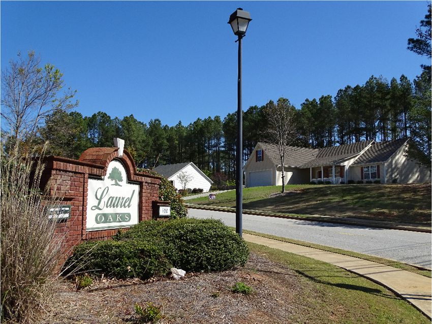
Acknowledgements                                                          Table of Contents
Walton County Unified Comprehensive Plan Steering Committee               Introduction & Overview .............................................................................................. 4
Kevin Little, Chairman, Walton County
Mike Martin, Planning Director, Walton County                             Process & Public Involvement...................................................................................... 5
Charna Parker, Assistant Planning Director, Walton County                     Walton County Public Input & Steering Committee ....................................... 5
Ashley Blackstone, Mayor, Between                                             City of Social Circle Public Input & Steering Committee ............................... 6
Jimmy Guthrie, Mayor, Good Hope
Randy Carithers, Mayor, Jersey                                            Needs & Opportunities.................................................................................................. 8
Dan Curry, Mayor, Loganville
                                                                              Gateways ....................................................................................................................... 8
Robbie Schwartz, Project Specialist, Loganville
Greg Thompson, Mayor, Monroe                                                  Infrastructure ................................................................................................................ 9
Pat Kelley, Planning Director, Monroe                                         Community Facilities, Parks & Recreation ......................................................... 10
Hal Dally, Mayor, Social Circle
Adele Schirmer, Manager, Social Circle                                        Community Involvement ....................................................................................... 12
Lamar Lee, Mayor, Walnut Grove                                                Economic Development ......................................................................................... 13
Shane Short, Executive Director, Development Authority of Walton County       Housing........................................................................................................................ 14
Mike Owens, President, Axis Risk Consulting
Eddie Sheppard, resident                                                  Vison 2040 ....................................................................................................................... 15
William Malcolm, resident
Chip Dempsey, resident                                                    Land Use .......................................................................................................................... 17

Social Circle                                                             Character Areas Compatibility Index ...................................................................... 18
Hal W. Dally, Mayor
David Keener, Mayor Pro Tem                                               Character Areas Defining Narrative ......................................................................... 20
Tyson Jackson, Council Member
                                                                          Community Work Program ........................................................................................ 35
Scott Simpkins, Council Member
Steve Shelton, Council Member                                                 Short-Term Work Program, 2017-2021 .............................................................. 36
Adele Schirmer, City Manager                                                  Report of Plan Accomplishments, 2012-2016 .................................................. 41
Susan Roper, Clerk
Jenny Watt, Marketing Coordinator                                         Appendix: Participation Records............................................................................... 45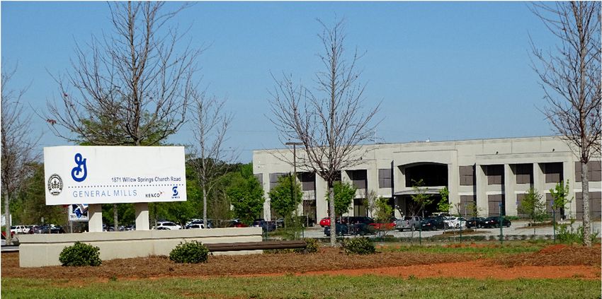
City of Social Circle Comprehensive Plan 2017 | Introduction & Overview

Chapter 1                                                                                                  Walton County Comprehensive Plan
Introduction & Overview                                                                                    Walton County, and the cities of Between, Good Hope, Jersey, Loganville,
                                                                                                           Monroe, Social Circle, and Walnut Grove joined together to complete a
Communities with a sense of place, a shared community vision, and a                                        Comprehensive Plan in June 2007.
commitment to achieving that vision through public and private action
are those that will thrive through changing times.                                                         Under State Law, a Comprehensive Plan for these jurisdictions requires
                                                                                                           update and adoption by June 30, 2017 (Loganville’s deadline is 2018).
A Comprehensive Plan is an organized way of determining community
needs and setting goals and objectives to address them. The                                                Walton County has contracted with the Northeast Georgia Regional
comprehensive plan provides guidance to orchestrate resources and                                          Commission (NEGRC) to prepare these plan updates. Social Circle has
events to achieve the desired vision of the community.                                                     opted to conduct its own supplemental planning activities and develop its
                                                                                                           own plan document.
Under the Georgia Planning Act, 1989…
“Coordinated and comprehensive planning by all levels of government within the State                       Social Circle Comprehensive Plan
of Georgia is of vital importance to the state and its citizens. The state has an essential
public interest in promoting, developing, sustaining, and assisting coordinated and                        The development of a City Comprehensive Plan was identified by the City
comprehensive planning by all levels of government. This article is intended to provide                    as an objective in the Annual Operating Budget for FY2016/17.
for the coordination of planning, at the direction of the Governor, by departments,
agencies, commissions, and other institutions of the state, and this article shall be liberally                     Objectives for Fiscal Year 2016‐-17
construed to achieve that end.”
                                                                                                           “City Comprehensive Plan will be developed, with extensive community input, which will
                                                                                                           add to the previously adopted Future Land Use plan a specific Vision for Social Circle. In
The Georgia Department of Community Affairs is designated to facilitate
                                                                                                           addition, the elements of the future land use plan will be described and details of
the oversight of Plans.                                                                                    intended timing, balance of uses, type of development, and long term infrastructure
                                                                                                           elements to support the vision will be included. A Comprehensive Plan will provide
The adoption of a compliant Comprehensive Plan enables the City to be a                                    additional written detail and dimension to the Future Land Use map to communicate to
qualified local government (QLG) with access to incentives such as CDBG                                    the public, future residents, potential industries, and commercial investors how the
grants and GEFA loans.                                                                                     community desires to guide the growth of Social Circle, to preserve its character unique
                                                                                                           identity and protect its historic fabric.”
                                                                                                  Page 4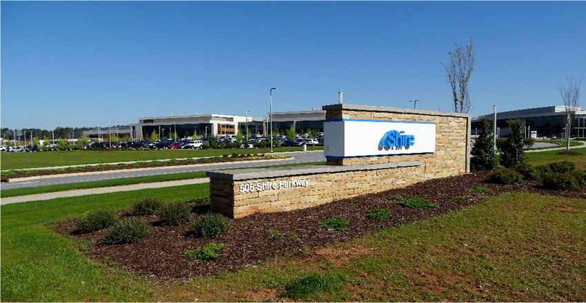
City of Social Circle Comprehensive Plan 2017 |

                                                                                  Walton County Public Input & Steering Committee
                                                                                  Walton County designated a steering committee for the 2017 update of
                                                                                  the Countywide Comprehensive Plan. The Steering Committee included
                                                                                  from Social Circle two elected officials, and Mike Owens. The NEGRC has
                                                                                  held three meetings with the designated steering committee towards the
Process & Public Involvement                                                      plan update. These meetings were held at the County Courthouse as
                                                                                  follows:
Under the Georgia standards, public participation must include
                                                                                  October 27, 2016; 2:30 pm     - public hearing
   1. Identification of Stakeholders
                                                                                  October 27, 2016; 3:00 pm     -overview of Process and input
   2. Identification of Public Participation Techniques
                                                                                  January 10, 2017; 2:30 pm     - review of Goals/Vision/SWOT Analysis
   3. Involvement with the Stakeholders with those techniques
                                                                                  January 26, 2017; 2:30 pm     -review of Work Program
   4. Legally required public hearings
                                                                                  Following the second steering committee meeting, the NEGRC
A steering committee must be used which includes elected officials and            determined that the overall Walton County Comprehensive Plan would
economic development professionals.                                               consist of a separate document for each community. With this approach,
                                                                                  the individual City identities and Vision could be reflected, while also
                                                                                  coordinating a Countywide perspective.

                                                                                  March 2017                    -NEGRC Delivery of Draft Plans April 2017
                                                                                                                -Public Hearing on Comprehensive Plan
                                                                                  (Countywide)

                                                                                  April/May 2017                -Submission of Plan to DCA for
                                                                                  Compliance Review

                                                                                  June 2017                     -Adoption by each Governing Body

                                                                         Page 5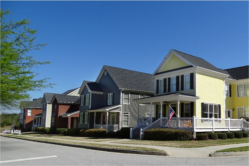
City of Social Circle Comprehensive Plan 2017 | Process & Public Involvement

City of Social Circle Public Input & Steering Committee
In addition to the NEGRC work on the Comprehensive Plan, a robust public input process was developed by Social Circle to gain community insight into the
Plan. A summary of the public input is provided below:

 Date, Time, Place                Invitees                                          Topics                                                       Attendees/Respondents
 July 25, 2016
 12 pm-1pm                        Rotary Club                                       City Vision                                                                20
 Magnolia Manor
 December, 2016                   Online Survey by UGA                              Downtown                                                                  246
                                  Mayor & Council, School Board, Sr. City Staff,
 January 6, 2017                                                                    City School Collaboration; Strengths & Opportunities                       25
                                  School Admin
 January 7, 2017                  Mayor & Council, Sr. City Staff, Planning
                                                                                    Overview; Stakeholder Identification; Public
 10 am- 2 pm, Saturday            Commission, Downtown Development Auth,                                                                                       23
                                                                                    Participation Techniques; Vision Elements; SWOT
 Community Room                   Main Street Board
 January 16, 2017                                                                   Plan Process; Upcoming Meetings; Notes from Prior
                                  Public                                                                                                                       -
 Web Page                                                                           Meetings; Survey Opportunity
 January , February                                                                 Plan Input Information ; Offer to Attend Group
                                  Public- Mailed with Utility Bills                                                                                            -
 Newsletters                                                                        Meetings
 January, February
                                  Public- CityofSocialCircle Facebook               Notice of Meeting Schedule Input Opportunities                             -
 Facebook Blasts
 January 23, 2017
 5 pm, Monday                     Public, Planning Commission                       General; Vision; SWOT Analysis                                             19
 Community Room
 January 26, 2017
 6 pm, Thursday                   Public, Tree Board, Garden Clubs                  Natural Resources; Vision; SWOT Analysis                                   10
 Social Circle Community Room
                                  High School Student Focus Groups in
 January 23-31, 2017                                                                Vision; SWOT Analysis                                                   50 +/-
                                  Advisory Classes
 January 31, 2017
                                  Public, Industry Representatives and
 11 am- 1pm, Tuesday                                                                Economic Development Focus; Vision; SWOT Analysis                          21
                                  Economic Development Professionals
 Social Circle Theater
 February 6, 2017
 7 pm, Monday                     Boy Scout Troop                                   General; Vision; SWOT Analysis                                             17
 Social Circle Methodist Church

                                                                                   Page 6
City of Social Circle Comprehensive Plan 2017 | Process & Public Involvement

Date, Time, Place                 Invitees                                           Topics                                                       Attendees/Respondents
February 9, 2017
                                  Public, SCDDA, Downtown property owners
11 am- 1 pm, Thursday                                                                Downtown Focus; Vision; SWOT Analysis                                     18
                                  and business owners
Magnolia Manor
February 13, 2017
8:30 am, Monday                   Public, MS/HS PTO                                  General; Vision; SWOT Analysis                                             6
Welcome Center
February 13, 2017
2:00 pm, Monday                   City Department Heads and Senior Staff             Infrastructure & General; Vision; SWOT Analysis                           10
City Hall
February 13, 2017
                                  Historic Preservation Society of Social Circle,
6:00 pm, Monday                                                                      Historic Resources; Vision; SWOT Analysis                                 17
                                  Historic Preservation Commission, Public
Gunter Hall
February 15, 2017
3:15 pm, Wednesday                Elementary School PTO                              General; Vision; SWOT Analysis                                             7
Social Circle Elementary School
February 18, 2017
9 am – 1pm, Saturday              Public- Drop In Opportunity                        General; Vision; SWOT Analysis                                             4
Welcome Center
February 20, 2017
                                  Public, Communities of Faith, Neighborhood
7:00 pm, Monday                                                                      Neighborhoods; Vision; SWOT Analysis                                       18
                                  Organizations
Mars Hill Fellowship Hall
February, 2017                    Web Based Survey                                  Vision; SWOT Analysis                                                      26
DRAFT REVIEWS
February 27, 2017                 Planning Commission                                Vision & Future Land Use
March 6, 2017                     Social Circle City School Board                    Vision & Future Land Use
March 9, 2017                     Downtown Development Auth                          Vision & Character Area
March 13, 2017                    Historic Preservation Commission                   Vision & Character Area
March 14, 2017                    Main Street Commission                             Vision Review & Character Area
March 23, 2017                    Tree Board                                         Vision Review
April 18, 2017                     Mayor & Council                                   Vision Review; Land Use; Character Areas; Work Plan

                                                                                    Page 7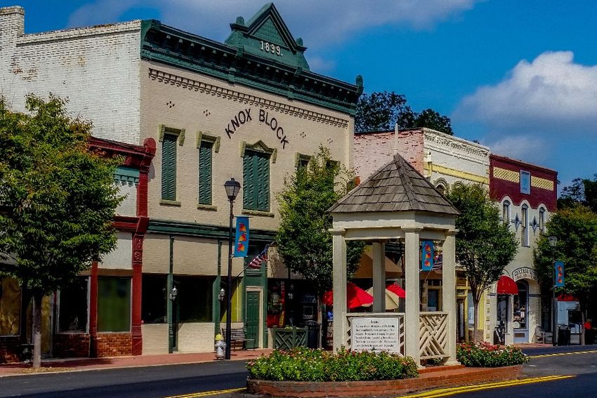
City of Social Circle Comprehensive Plan 2017 | Needs & Opportunities
Chapter 2 Gateways
Needs
The edges of the City are not apparent, and some of the approaches
Needs & Opportunities into the City could be much improved.
The following list of needs and opportunities results from a Strengths, Community, downtown activities are not well promoted with signage.
Weaknesses, Opportunities, and Threats (SWOT) analysis conducted from
all public meetings and survey results during the months of January and Opportunities
February 2017, with both steering committee and public present, as well
The city is surrounded by rural areas, which presents an opportunity to
as professional analysis of relevant data and results of the online
create a sense of arrival and a strong first impression which reflects the
questionnaire.
values of the community. Each roadway entrance into the City limits
should be accommodated with a sign, with a consistent design motif,
*Italicized entries indicate high priorities
scaled per the roadway, and extensively landscaped and maintained
like a front entry. Each gateway sign provides an opportunity for a
special event banner or placard which can be changed, creating
interest and attention.
The Exits off I-20 to Social Circle provide the strongest opportunity to
create a sense of arrival and draw traffic from the interstate into the
city. These gateway signs should be carefully placed to create a
terminated vista, should be sized per the roadway and traffic volume,
should have a consistent motif which reflects the community
character, and should be well set back from the roadway with
extensive and manicured landscaping. The gateway signage at the
interstate exits should be the dominant visual element greeting the
driver as they enter the City.
Page 8
City of Social Circle Comprehensive Plan 2017 | Needs & Opportunities
Infrastructure
Needs Opportunities
The City water treatment plant is limited in capacity to 1 MGD. Future Walton County, the City of Monroe, and Newton County Water and
growth in industry and population will require additional water supply. Sewer Authority have excess water treatment capacity and distribution
systems that are feasible for interconnection. Regional water
The City water distribution system is aged and the network suffers treatment capacity is available.
from lack of interconnection internally and to adjacent water systems.
This results in areas of poor water pressure and flow. The Newton County Water and Sewer Authority has excess sewer
treatment capacity available, and is located topographically
The City wastewater treatment plant is aged and limited in capacity. downstream from the City, providing an opportunity for regional
Future growth in industry and population will require additional cooperation and removal of a significant number of pump stations
treatment capacity. from the City system.
The City wastewater collection system is aged and constrained by an A master plan which details short and long term water and sewer
excessive number of pump stations which load the collection system. system improvements with priorities will position the City well for
High inflow and infiltration during heavy rain events exacerbates implementation of critical improvements in a logical sequence and will
capacity constraints. maximize opportunities for state and federal grant assistance, and
public private partnerships through the development process, and
Areas of the City storm water drainage system and waterways are consideration of impact fees.
subject to overflow and flooding during heavy rains. Erosion is
apparent in some locations. Water quality measures are needed to Establishment of a storm water utility fee would provide revenue
protect the waterways within the City. related to property impact which would enable funding of storm water
improvements to address flooding and water quality treatment.
Roadways within the City need pavement restoration. Current
funding levels are inadequate to maintain pavement condition. Walton County owns and operates paving equipment. City taxes
support the County labor and equipment for paving streets. A
partnership between the City and County in which the City pays for
paving materials, and the County provides labor and equipment
would extend the amount of roadway pavement maintenance
provided.
Page 9
City of Social Circle Comprehensive Plan 2017 | Needs & Opportunities
Community Facilities, Parks & Recreation
Needs Opportunities
There is a shortage of parks and recreational opportunities for There is much open space and undeveloped land within the City
residents. Passive parks are needed within neighborhoods and public which provides an opportunity for a park network to be planned,
passive parks are needed in all areas of the City. which can be implemented prior to or in conjunction with future
development. This enhances public private partnership opportunities
An off road trail system is needed which provides for bike, and and the ability to set aside sensitive environmental areas for passive
pedestrian access throughout the City with a minimum of roadway park use, and other areas for active recreation uses.
crossings. This trail system should provide for connections between
the downtown, neighborhoods, parks, schools, and employment Extensive Citizen interest in a trail network provides the opportunity to
centers to serve for recreation and non- vehicle access options. develop a trails master plan for the community. There is much open
space and undeveloped land within the City which provides an
A public recreation facility is needed within the City which provides a opportunity for a trail network to be integrated into sensitive
gym, indoor exercise equipment, rooms for fitness classes, rooms for environmental areas such as stream corridors, and to connect to parks,
wellness and nutrition education, and other related needs. schools, and neighborhoods.
The Senior Center is currently a shared space with the courtroom. A A recreation center in Social Circle would serve a regional County
space is needed in which more services can be provided to the seniors, need, and would fulfill the past County plans for a recreation center in
such as health and wellness classes, games, recreation and fitness, and each City in Walton County. This project would be SPLOST eligible.
activity centers.
A recreation center in Social Circle would facilitate the programming
Recreation programming within the City is provided by Walton of additional recreational opportunities for youth and Seniors in the
County, and is limited. Additional programming is needed to provide City. This would serve senior center and activity needs.
local youth an opportunity to participate in organized sports and
activities without need to commute to neighboring Cities. The City and Uncle Remus Library Board have funded the local share
for the Library expansion, and the site parking has been reconfigured
The library needs expansion to serve the current and future residents to accommodate the building expansion. Preparation of Schematic
and integrate opportunity for access to technology into the facility. and Design Development plans will strengthen the attainment of
State funds for the expansion project.
Public meetings, including Council meetings and appointed Boards
and Commissions, are held in the Community Room. Audio visual and Rehabilitation of the community room to better serve AV needs for
sound equipment is needed to enhance the ability for the audience to public meetings would also enhance the opportunity to film and
follow presentations and discussion. broadcast public meetings.
Page 10
City of Social Circle Comprehensive Plan 2017 | Needs & Opportunities
Community Facilities, Parks & Recreation Opportunities (Continued)
Stephens Park is an opportunity for more community recreation and
activity. The fencing, lighting and restroom and press box facilities in
place provide the basic infrastructure for significant community
festivals, recreation, and concerts.
The County owned Pond site opposite the South Walton Recreation
Park and Ballfields creates an opportunity for a passive park, native
landscaping, an educational water feature, and an internal trail system
that connects to the Citywide trail network.
Consider a community pool or splash pad park.
Teen activity areas are needed, such as indoor trampoline, rock
climbing, gametime, skyzone, etc.
Page 11City of Social Circle Comprehensive Plan 2017 | Needs & Opportunities
Community Involvement
Needs Opportunities
There is significant involvement by civic groups and volunteers in A community leadership program would educate citizens on Social
community activities, however there is less awareness of opportunities Circle government services and provide an opportunity for citizens to
for appointment to Boards and Commissions. apply for consideration to Board and Commission appointments.
Opportunities to develop youth leadership are limited. Focus groups could be created for specific issues or plans which
include youth and all ages, to build leadership in the community and
Interaction relating to community issues between youth, professionals, obtain broad input and consensus on community issues.
and seniors and retirees is limited which leads to lack of understanding
between generations. An internship and mentoring program at Social Circle City Schools by
local professionals and employers could build job opportunities for
More interaction is needed between City Schools and City graduates, and provide experience and development of critical work
Government and local employers to build internship opportunities and skills while strengthening the match between the local residents and
provide for professional skill development and work ethic training. employment needs of current employers.
Local residents are not aware of local employment opportunities by A local facebook page or employment posting could facilitate the
businesses and industries. match of the local population with available jobs in the community.
This enhance workforce development and employee retention for local
Communication from City government to residents is lacking. industry, reduce unemployment within the City, and reduce commuter
Website, Facebook, and monthly newsletters provide some traffic.
information, but more is needed on ongoing issues.
A periodic town hall type meeting relating to City business would be
City Council meetings and Boards and Commissions are not beneficial to maintain community dialogue and provide updates on
broadcast, thus it is difficult for residents to stay informed. ongoing programs or projects.
Through a partnership with the Social Circle School system, or
adjacent Technical Colleges, public meetings could be filmed and
broadcast via youtube and linked to the website providing the ability
for those who cannot attend meetings to stay informed. A local radio
show or “e-news” paper could also be created though such a
partnership providing valuable experience and exposure to students.
Page 12City of Social Circle Comprehensive Plan 2017 | Needs & Opportunities
Economic Development
Needs Opportunities
More activities are needed for corporate visitors after hours. Walton Economic Development Authority is promoting a program for
workforce development that would create a training pipeline between
Local industry growth rates need to be projected and communicated the public high schools, at the technical colleges and the local
to the school systems so they can create the training program and industry.
capacity that will fill the need at the time needed.
There is a need by the movie and tv industry for filming locations.
More entertainment options are needed for youth.
Interest in Social Circle tourism can be created through promotion of
the films that have been located in Social Circle, as well as future films.
For example, a baseball themed focus could link area tournaments
with the filming of “42”.
A weekend, drive in theater may be an attraction for area
entertainment that can be located in a rural area, separated from
neighborhoods.
Page 13City of Social Circle Comprehensive Plan 2017 | Needs & Opportunities
Housing
Needs Opportunities
A shortage of housing exists in the $250,000 - $500,000 range. The City is attractive to new residents due to area employers, the
Potential homebuyers are looking for housing within the City within strong school system, and easy access to the Atlanta metropolitan
this range and it is not available. There is ample housing in the starter area. This demand supports the provision of attractive neighborhood
home range of affordability. development, and enables property values in existing neighborhoods
to be maintained.
Code enforcement is needed to address run down homes, lack of lawn
and building maintenance in some neighborhoods, and zoning Citizens’ desire for stronger Code enforcement indicates pride in the
violations and abandoned vehicles. Citizens take pride in every community and creates an opportunity to build community
neighborhood and additional enforcement support is needed to involvement within neighborhoods for cleanup days and neighbor
address the occasional problem property which affects the assistance.
attractiveness of the neighborhood.
Demand for rental housing creates an opportunity to reduce vacant
The Rental housing market is very tight, making it difficult for those homes and creates financial feasibility for investor improvement of
who do not wish to buy to locate in the area. existing housing stock.
While there is housing around the downtown, there are no downtown The demand for rental housing and desirability of downtown living for
living options. some residents supports the feasibility of developing downtown
housing in the Mill area.
Page 14City of Social Circle Comprehensive Plan 2017 | Vison 2040
Chapter 3 Surrounded by rural countryside, each gateway into the City provides a
sense of arrival, and displays attractive welcoming and colorfully
landscaped signage that indicates residents’ pride in their community.
The City enjoys clean air, clean water, protected natural water ways, and is
Vison 2040 within a short drive to the Hard Labor Creek Reservoir, Golf courses, Hard
Labor Creek State Park, and Charlie Elliott Nature Center. The Georgia
Social Circle is a picturesque city, which retains its Victorian charm and Department of Natural Resources is headquartered in Social Circle, and
authentic historic downtown, within the historic Georgia Heartland. Social promotes and provides opportunities for citizens to enjoy Georgia nature.
Circle is a rare city within commuting proximity to Atlanta that remains
separated from the urban sprawl, and welcomes economic activity and The authentic historic downtown is located within the center of the City
growth in a manner and form that strengthens its sense of place. Social and is the heart of the community. Vibrant with activity, variety,
Circle is a sustainable, adaptable community with abundant natural shopping, dining and downtown living, it is an attraction to residents and
resources nearby. It is a walkable, friendly, community that retains its small tourists alike.
town charm and hometown feel with a high quality of life for residents.
Spanning out from the downtown is a well preserved residential historic
Social Circle is a complete community with a variety of attractive district in which homes predominate and Bed and Breakfast Inns are
neighborhoods, a highly rated independent school system, abundant sensitively tucked providing a delightful accommodation for visitors
recreation and activity opportunities for all ages, and a variety of without changing the residential character of the district. The character of
commercial areas including an authentic historic downtown, with unique the historic district is protected through preservation and restoration of all
shops and restaurants and frequent festivals and entertainment, as well as contributing buildings.
larger commercial centers at the North end of the City, and along the
Social Circle Parkway to the east, and at the I-20 interchange. The Social Neighborhoods radiate from the downtown in all directions, such that all
Circle Parkway provides convenient access via a scenic tree lined corridor are walkable to the downtown and sidewalks are continuous along the
through rural countryside to an Athens Technical College Campus, and an streets. Street trees line the roadways providing shade and clean air, and
expansive industrial sector which provides a wealth of employment attractiveness. Housing of all price ranges and many styles is provided
options and is well served with power, rail, natural gas, and water and within the City, and every neighborhood is well maintained and safe and
sewer. secure. A perimeter roadway extends from North Cherokee Road around
the west side of the City to South Cherokee, providing access between
neighborhoods.
Page 15City of Social Circle Comprehensive Plan 2017 | Vison 2040
Community parks are located throughout the City, with trail and roadway The Social Circle parkway provides a convenient route for traffic from I-20
connections providing for easy access from neighborhoods. A trail and to the thriving Industrial area located to the northeast of the City center.
bicycle path network encircles the city adjacent to the Parkway, and The Industries are clustered in this area, and are identified with high
connects to the downtown, school campuses, parks and recreation areas, quality buildings, corridor landscaping which provides a campus like feel
and neighborhoods. The trail network winds through and around to the Parkway and attractive well landscaped monument signage. The
neighborhoods by following creeks and water ways, and minimizing industries are energy efficient and environmentally sensitive providing a
roadway crossings. clean and healthy environment for those working in and living around the
industry.
A City Transit system provides service throughout the community,
enabling easy access to schools, industry, shopping, and other Transparency and fiscal conservatism in government and a high level of
destinations. volunteerism and engagement in Civic organizations characterize the
community. The varied civic groups continue a strong tradition of
The independent City School system is exceptional as compared nationally working together to provide for the needs of the community. City services
and is a key attraction to the City. The school facilities are current and are efficient and effective and responsive to the needs and priorities of the
progressive, the curriculum is responsive to the needs of all students, and community. Infrastructure is reliable, sustainable, and compliant and
the school provides a strong foundation for college bound as well as continually updated to support economic growth and environmental
skilled labor. There is partnership between the school and local industry considerations.
and business which provides for mentoring, internships, and development
of the future work force needed in the Social Circle.
The Athletic complex at the High School provides exceptional facilities for
competitive sports and the School sports activities are supported by the
community with high attendance and sponsorship. In addition, athletic
parks are located within the city to provide for baseball, softball, soccer,
and football. A recreation center serves the community and provides for
basketball, volleyball and other health and wellness programs.
Youth activities abound, with opportunities for organized team sports, as
well as dance, theater, hiking, biking, and more. Community focus groups
promote youth involvement and develop leadership opportunities.
A commercial area is centered around the intersection of North Cherokee
Road and Route 11, providing a high visibility attractive center which
ample parking around the stores, and landscaped street frontage which
fosters the Social Circle gateway image.
Page 16City of Social Circle Comprehensive Plan 2017 | Land Use
Chapter 4
Land Use Has unique or special characteristics to be preserved or enhanced
(such as a downtown, a historic district, [an] arts district, a
neighborhood, or a transportation corridor);
Pursuant to the rules of the Georgia Department of Community Affairs,
the following Character Areas Map and Defining Narrative provide the Has potential to evolve into a unique area with more intentional
physical planning component of the comprehensive plan. guidance of future development through adequate planning and
implementation (such as a strip commercial corridor that could be
The DCA defines a character area as a specific district or section of the
revitalized into a more attractive village development pattern); or
community that:
Requires special attention due to unique development issues
(rapid change of development patterns, economic decline, etc.)
Character areas typically provide greater flexibility than traditional
future land use maps, in which each parcel is assigned a single
category such as Residential or Commercial.
Page 17City of Social Circle Comprehensive Plan 2017 | Character Areas Compatibility Index
The following table provides an overview of each of the character areas, including a brief description, zoning compatibility, and appropriate land uses for
each:
Character Areas Compatibility Index
CHARACTER AREA DESCRIPTION OF CHARACTER AREA ZONING COMPATIBILITY* APPROPRIATE LAND USES*
Pasture lands and woodlands, conservation areas and open
Agricultural & Estate lands, cultivated agriculture, agritourism, farms, and residences Residential, Agricultural,
Agricultural, Agricultural -2
Single Family Residential associated with farms or on larger tracts of land with pastoral Agritourism,
views and a high degree of building separation
Existing neighborhoods and land planned for future residential
development. Smaller lots, predominantly single-family
R15, R25, Residential Medium
residential, walkable areas with complete streets, preserved tree
Neighborhoods Density, Planned Unit Single Family residential
canopy, and neighborhood-appropriate commercial
Development
activity. Public schools, parks and recreation areas are located
within or adjacent to the neighborhood character areas.
Small lot and multifamily residential areas with low intensity
Residential Medium Density, NC,
commercial uses. These village scale areas are walkable and Residential, Neighborhood
Village Residential Residential High Density, Planned
compact and provide for traditional neighborhood patterns and Commercial
Unit
live work development patterns.
Predominately single family homes located within a local historic
district. Sensitive commercial uses which enhance the historic
character of the district and preserve the contributing buildings
R-25, R-15, NC, Residential Residential, Office, Commercial,
Historic Residential and property characteristics are permitted. This is a highly
Medium Density Institutional
walkable area with mature trees and characteristic walls and
fences which blends seamlessly into the downtown historic
district.
Historic downtown district including rail depot and warehouses
and mill buildings. Sidewalks are wide and shaded with
streetside commercial activity. The character of the area is
Commercial, Office, Residential,
Downtown preserved through a local historic district. The downtown hosts CBD, NC, PUD, RMD
Government, Recreation
frequent festivals and activities and is the heart and soul of the
community. Churches, parks, and theater are located downtown
in a scale which does not dominate adjacent properties.
Continued on next page…
Page 18City of Social Circle Comprehensive Plan 2017 | Character Areas Compatibility Index
Character Areas Compatibility Index (continued)
CHARACTER AREA DESCRIPTION OF CHARACTER AREA ZONING COMPATIBILITY* APPROPRIATE LAND USES*
Larger scale commercial businesses which cannot be
accommodated downtown and institutions such as College
Office/ Institutional, General
campuses define this character area. Not a strip commercial Commercial, Office, Institutional,
Commercial Institutional Commercial, Mixed Use Business
pattern, this area is marked by centralized entrances, shared Recreation,
Park
parking, mature and extensive landscaping, and a coordinated
architectural style.
A commercial and mixed use employment center area. The
interchange character area presents prominent distinctive General Commercial, Light
Commercial, Industrial, Office,
Gateway Interchange landscaping and a sense of arrival from the Interchange. Large Industrial, Heavy Industrial, Mixed
Institutional
scale buildings are well set back from the roadway, landscaped, Use Business Park
and accessed through consolidated entrances.
Industrial uses predominate. Entrances are well signed, Building
I-1 Light Industrial, I-2 Heavy
entries are distinctively landscaped, a landscaped buffer with
Industrial Industrial, MUB Mixed Use Industry, Offices
greenway trail network separates industrial areas from road
Business Park
frontage preserving the aesthetic character of the City.
*Note: not all zoning and land use classifications will necessarily be appropriate in all locations within a character area.
Page 19City of Social Circle Comprehensive Plan 2017 | Character Areas Defining Narrative
Character Areas Defining Narrative
Agricultural & Estate Single Family Residential
The City of Social Circle is nestled within a rural area, and surrounded by
Agricultural zoning in the adjacent unincorporated County areas. The
Agricultural and Large Lot residential character area provides an
opportunity for farms and estate homes to protect the rural edges of the
City and provide the transition into the City center while maintaining the
sense of entry into a historic community and small town atmosphere.
Within the Agricultural and Large Lot residential area homes and buildings
are set back from the roadways, and off road trails may meander adjacent
to the roadways but are separated from them. Farms, forests, and
pastures characterize the area and livestock is common. Agritourism type
businesses are encouraged in this character area which are sensitive to and
reflect the rural character. Examples may include farm setting catering or
wedding venues, large animal veterinary clinics, beds and breakfasts, or
farm to table restaurants. The structures in this character area should be
residential or rural agricultural in style and drives and parking areas
sensitively placed and out of view from the adjacent roadways.
Compatibility
ZONING COMPATIBILITY APPROPRIATE LAND USES
Agricultural, Agricultural -2 Residential, Agricultural, Agri-tourism,
Page 20City of Social Circle Comprehensive Plan 2017 | Character Areas Defining Narrative
Implementation Measures
Create a western perimeter roadway route with a stakeholders group
Maintain buffer areas between agriculture and residential
that will provide for connections between neighborhoods and
neighborhoods
facilitate traffic circulation
Plan and implement an off road trail network that spans throughout
Provide for conditional uses within the Agricultural zoning districts
the city, connects to parks, schools, neighborhoods and the
which allow for appropriate agri-tourism and agri-businesses.
downtown.
Page 21City of Social Circle Comprehensive Plan 2017 | Character Areas Defining Narrative
Neighborhoods
Neighborhoods radiate from the downtown in all directions, such that all A City library is located centrally, walkable from the City schools and most
are walkable to the downtown and sidewalks are continuous along the neighborhoods. The library is well supported by the community and
streets. Street trees line the roadways providing shade and clean air, and provides a variety of activities for families, seniors, students and youth.
attractiveness. Housing of all price ranges and many styles is provided
within the City, and every neighborhood is well maintained and safe and Social Circle City Schools are located adjacent to neighborhoods
secure. Golf carts are a popular mode of transportation within facilitating community involvement in the schools and easy pedestrian
neighborhoods and along City streets to the downtown, parks, and and bicycle access by students.
recreation areas.
Compatibility
Neighborhood residents and associations are active in looking out for each
ZONING COMPATIBILITY APPROPRIATE LAND USES
other, participating in community cleanups and improvement activities,
R15, R25, Residential Medium
and other volunteer and civic activities. Single Family residential
Density, Planned Unit Development
Properties are well maintained, trees and flowers and gardens and forests
greet the eye, where civic engagement is reflected in every neighborhood.
Small neighborhood convenience stores and historic markets are located
in some neighborhoods to provide for convenience and maintain the
history of these micro communities, but remain small, and limited in hours
and activity so as to not detract from the residential quality of life. These
shops are conditional uses, such that the impact of each is evaluated
individually and restricted to maintain the residential character of the area.
Paths and recreational amenities such as pools, clubhouses, and
playgrounds are located within neighborhoods to foster quality of life and
informal gatherings and fellowship.
A citywide trail and bicycle path network encircles the city adjacent to the
Parkway, and connects to the downtown, school campuses, parks and
recreation areas, and neighborhoods. The trail network winds through and
around neighborhoods by following creeks and water ways, and
minimizing roadway crossings.
Page 22City of Social Circle Comprehensive Plan 2017 | Character Areas Defining Narrative
Implementation Measures
Provide speed enforcement and driver education to minimize
Encourage development of residential neighborhoods which fill
speeding traffic and enhance bike, pedestrian, and golf cart safety.
market needs and are consistent with the character of the City and
provide amenities such as trails, playgrounds, and other community Require stormwater management facilities that are attractive and
recreation or gathering areas. effective and are an attraction, rather than a detriment to
neighborhoods, consider rehabilitation of existing facilities
Develop a comprehensive trail plan to identify the future trail network
accordingly.
so that it is implemented with development and through grant
opportunities. Create a western perimeter roadway route with a stakeholders group
that will provide for connections between neighborhoods and
Create neighborhood watch and partnership with Police to enhance
facilitate traffic circulation
safety and security in all neighborhoods.
Use code enforcement and consider derelict property millage rate
increase to facilitate the correction of code violations and derelict
structures.
Page 23City of Social Circle Comprehensive Plan 2017 | Character Areas Defining Narrative
Village Residential
The Urban Village character area provides for small areas of more dense or
clustered housing with micro-commercial shops. The village character
area allows for live work housing where a small shop may be located
below with a residence above. Within the urban village character area,
buildings are close to the streets and sidewalks are provided throughout.
Parking is in the rear or in alleys. Street trees are provided throughout the
area, and small squares or pocket parks are interspersed. The Urban
village harkens to Charleston or Savannah type row houses and traditional
neighborhood patterns with a grid street network. The Urban Village
character areas are small, not more than 30 acres in size, and retain
architectural style and character that is consistent with the Social Circle
small town feel. Individual residences may be smaller than found
elsewhere in the City, however quality and detail of design is high such
that these neighborhoods maintain their value over time. The walkways
within the neighborhood connect to the Citywide trail system.
Capability
ZONING COMPATIBILITY APPROPRIATE LAND USES Implementation Measures
Residential Medium Density, NC, Residential, Neighborhood Encourage development of urban village neighborhoods which fill
Residential High Density, Planned Unit Commercial market needs and are consistent with the character of the City. These
neighborhoods may meet the desires of young professionals and
those attracted to urban living within the Social Circle area.
Evaluate Zoning and Subdivision ordinance provisions to assure they
provide for the desired character area attributes.
Page 24City of Social Circle Comprehensive Plan 2017 | Character Areas Defining Narrative
Historic Residential
Within the historic character area, signage, streetlights, and historic
Spanning outward from the downtown is a well preserved residential information markers area located to emphasize the significant history
historic district in which homes predominate and Bed and Breakfast Inns specific to Social Circle. Two historic cemeteries are located within the
are sensitively tucked providing a delightful accommodation for visitors district. These manicured sites, with markers dating back over 200 years,
without changing the residential character of the district. The character of provide an attraction for tourism and reflect the generations of many
the historic district is protected through preservation and restoration of all families still a part of the community.
contributing buildings.
The size of the historic character area, and the level of preservation of the
The structures in the district represent the major architectural styles and building fabric is unique to Social Circle and highly valued throughout the
periods of the time. Included are examples of Greek Revival, Plantation community. The local historic district zoning, overseen by the Historic
Plain, Gothic Revival, Second Empire, Queen Anne, American Victorian, Preservation Commission serves to guide activities within the district to
Victorian Eclectic, Italianate, Colonial, Georgian, NeoClassical, “Half- maintain this cherished identity.
Houses,” Federal, Bungalow, Tudor, Craftsman, and Ranch.
Compatibility
The tree lined streets and well-kept public and private properties are
reflective of the early 1900’s. Sidewalks are located along all streets and ZONING COMPATIBILITY APPROPRIATE LAND USES
are shaded with street trees. Driveway connections are narrow, and R-25, R-15, NC, Residential Residential, Office, Commercial,
parking is typically beside or behind the homes and buildings. Medium Density Institutional
The iconic Gunter Hall, an 1840’s era building which has adorned three
different sites within the City, is preserved by the Historic Preservation
Society of Social Circle and available for rent to the public for meetings
and events.
New construction, fences, landscape and driveways are sensitive to and
complement the historic district character. The community history and
heritage is exhibited through the beauty of the buildings and placement.
With the historic homes, are located Churches and small shops which
retain the character of their construction. Noteworthy are the Methodist
church and the Mill Village store. In addition, there are some structures
along the main roadways which are preserved in their historic character,
while used for low intensity office or commercial, as a conditional use. The
scale and number of these conditional uses is small so as not to change
the historic character of the corridor.
Page 25City of Social Circle Comprehensive Plan 2017 | Character Areas Defining Narrative
Implementation Measures
Provide sidewalks along the frontage of all streets within the historic
Continue use of the Local Historic District to preserve existing
character area, and maintain existing sidewalks to remain accessible
buildings, and maintain the character of the district.
and attractive.
Promote and educate the community on the rich local history to
Encourage infill development, and assure the compatibility with the
encourage rehabilitation and maintenance of structures and properties
surrounding properties
Expand advertisement of the historic properties and settings to
Use code enforcement and consider derelict property millage rate
promote tourism and business.
increase to facilitate the correction of code violations and
Remove aged and dying oak trees in the right of way and plant maintenance of historic properties, to avoid demolition by neglect.
understory trees and encourage planting of large canopy trees within
front yards
Page 26City of Social Circle Comprehensive Plan 2017 | Character Areas Defining Narrative
Downtown
An entrepreneurial atmosphere is apparent in the downtown where
In the center of the City, the authentic historic downtown is filled with modern businesses, film industry, and marketing and service proprietors
shops and restaurants and businesses that are unique and home grown. share space with arts and crafts, restaurants, clothing stores, and unique
Every storefront is active and the sidewalks are full of activity and energy storefronts. Broadband and high speed internet service support business
and people of all ages. Sidewalk cafes dot the streetscape, colorful plants growth.
adorn the storefronts and hanging baskets adorn the post top streetlights.
A City Square is located in the downtown which provides for a farmer’s Parking is plentiful, but hidden in small lots throughout the area, and
market, a gathering space for picnics and lingering in the mild climate, a shared lots in the Churches and Schools adjacent to the downtown, and
venue for frequent festivals, and a stage which supports live music events golf cart and horse and carriage shuttles provide practical and enjoyable
in a gently sloping amphitheater. shuttles between the parking and the stores.
The iconic City Well is a focal point, well landscaped and lit and seasonally New construction within the historic downtown is sensitive in context and
decorated which reminds of the history of the City. Vehicle traffic is slow, design so as to complement the charm and character of the downtown
yet steady, providing a steady stream of customers. Golf carts, bikes, and provides for loft living opportunities.
strollers, and pedestrians abound due to the proximity of the downtown
to neighborhoods. Sidewalks are wide and shaded with street side dining and information
gathering spaces. The architectural character of the buildings is preserved
Churches are dotted around the downtown and bolster the family and signage is visible, while consistent with the historic styles. A variety of
atmosphere, the weeklong activity, and the safety and stability of the area displays activate the storefronts and invite shoppers.
while respecting the scale of the buildings in the district and do not
dominate the adjacent properties. Compatibility
The Social Circle Theater is located to the east of Downtown, providing a ZONING COMPATIBILITY APPROPRIATE LAND USES
venue for live theater and dance and youth productions. Commercial, Office, Residential,
CBD, NC, PUD, RMD
Government, Recreation
On the southern end of downtown, the historic depot, mill, and
warehouses around the train tracks are restored and active with small
businesses and downtown living. The train tracks are in active use and the
locomotives, and train cars draw tourists viewing the historic cooling
tower, and relics of commerce and passenger movement of the past.
The Mill area extends adjacent to a large green space with springs that
provide pleasing water features and native landscaping in the shadow of
the downtown.
Page 27City of Social Circle Comprehensive Plan 2017 | Character Areas Defining Narrative
Implementation Measures
Implement code enforcement and blight tax rates as necessary to
Create an environment for business vitality downtown. Use National
effect building maintenance of historic downtown structures being
Main Street Program, incentives, entrepreneur development, business
neglected.
recruitment, shop local, festivals, decorations, and other programs to
generate activity and interest downtown. Consider iconic businesses Consider a program to encourage the division of larger spaces to
such as Blue Willow which have national identity, and support and smaller areas to enable more business variety on a more affordable
enhance that presence through marketing. scale. Consider creating business fronts on the alleys to divide spaces
and expand storefront opportunities.
Identify and remove barriers to repurposing historic buildings.
Facilitate the improvement of downtown buildings, and development Engage the downtown property owners and business owners to
of new and rehabilitation of vacant structures using the Downtown update the downtown master plan to include sidewalk widening and
Development Authority, historic tax credits, and other incentive street side cafes, parking areas, downtown square, lodging, mill area,
programs. and downtown living opportunities.
Facilitate new business activity downtown through expedited issuance
of permits, incentive programs to address code compliance (façade
grants, fire and electrical upgrades,) and consider grants for A/E
assistance through DDA.
Improve the public spaces downtown to beautify the area, and to
attract residents, and invite tourists and facilitate commercial activity.
Recognize that small changes can have major positive impact.
Walkability of the downtown should be enhanced, with sidewalk
maintenance, and well-lit expansions to promote pedestrian
friendliness.
Create a square, gathering area, in the downtown to facilitate events,
lunch time activities, a farmer’s market, concerts, and casual
enjoyment of the area.
Create the identity of Social Circle downtown as the “home town” of
the surrounding region, to build ownership and support of businesses
and activities downtown.
Page 28City of Social Circle Comprehensive Plan 2017 | Character Areas Defining Narrative
Commercial Institutional
The commercial and institutional character areas are planned to provide Sidewalks provide connections within the commercial and institutional
for convenient larger scale businesses which cannot be accommodated area from parking to buildings and between buildings such that it is safe
downtown. The mix of uses should be such that they do not duplicate or and inviting for shoppers to walk from store to store within the Center.
draw from the downtown, but provide additional larger scale stores or
entertainment venues such as movie theaters. The eastern Commercial and Institutional Character area spans both sides
of the Parkway. A parkway perimeter trail is planned and trail system
The commercial and institutional character areas provide for larger scale connections should be provided which follow natural drainageways and
commercial or institutional uses clustered together with consolidated streams and which lead radially back to the downtown to promote
access points and shared or connected parking. Large expanses of connectivity and the ability for residents to walk and bike throughout the
parking are discouraged. Buildings and parking should be arranged to City. The parkway bridges within this character area provide opportunity
create an integrated village type layout. Landscaping is provided along for trail crossings under the parkway to provide for safety. The Athens
the road frontage and within parking areas to provide shade and aesthetic Tech Campus is a key element of this character area. This campus feel will
appeal. Signage at the consolidated entries is encouraged which set the tone for the surrounding commercial and institutional
identifies the center and the businesses within the center. Architecture development in terms of architecture, landscaping, and sensitivity to the
which is conducive to the business, yet also reflects and enhances the topography of the area.
small town feel of the area is encouraged.
Compatibility
Commercial properties are grouped together in nodes located at the north
end of the City at the intersection of North Cherokee and the Social Circle ZONING COMPATIBILITY APPROPRIATE LAND USES
Parkway (State Route 11), and clustered together adjacent to the Social Office/ Institutional, General Commercial, Office,
Circle Parkway (State Route 11) and including the Athens Technical Commercial, Mixed Use Business Park Institutional, Recreation
College Campus. Each of the two areas has a unique focus.
The northern Commercial and Institutional Character area provides the
opportunity for a strong sense of entry into the city. The intersection of
Rte. 11 and North Cherokee provide the setting for highly landscaped and
attractive Gateway signage welcoming visitors and reinforcing the sense
of place. In addition, this gateway signage should route Industrial traffic
to the Parkway. The northern Commercial and Institutional character area
supports medical offices and facilities as well as grocery stores and similar
larger retail. Attractive signage, and Street trees and landscaping are
encouraged. Trails should be provided adjacent to the parkway and along
North Cherokee that are safe and inviting for pedestrian and bicycle use.
Page 29You can also read