City PLANTastic Unitec Arboretum
←
→
Page content transcription
If your browser does not render page correctly, please read the page content below
City PLANTastic

                                  Unitec Arboretum

                                     Penny Cliffin
                         Department of Landscape Architecture
                            Unitec Institute of Technology
                                pcliffin@unitec.ac.nz

Keywords
Urban Forest, Greening of cities, Urban Trees, Online Plant Databases, Arboreta, Parks,
Biodiversity.

Abstract
Greening of cities has become a significant motivation for landscape architects, urban
designers, and architects, as well as a growing public expectation. While there is need
for the development of new technologies to accomplish some of this greening, a
reappraisal of traditional New Zealand parks (19th century), often modelled on the
English Landscape parks of earlier centuries, such as found at the Unitec campus, may
also offer innovative contributions to the understanding of green networks (or urban
forest) in the city, through their plant selection, management, promotion and evolution.

Unitec Institute of Technology, in Auckland, New Zealand, is well known locally for its
park like grounds. Unitec’s campus and tree collection can also be understood in its
wider urban vegetation context, and has potential to be developed into a more widely
recognised and utilised arboretum resource. The tree collection has been documented by
the institute, assisted by research from botanist Mike Wilcox (1996) and senior lecturer
Penny Cliffin (2001).

This paper will illustrate the project progress to date, and reflect on the impact of these
developments in relation to urban vegetation values, such as biodiversity, green
infrastructure and watershed management, public recreation, amenity and education.
Students are currently developing concepts for the arboretum including improved path
networks, connections to the wider community via pedestrian and cycleways, and
planting proposals for enhancing Arboretum themes such as bird habitat and fruiting
trees as well as experiential aspects of spatial design. Along with this design exercise,
students are undertaking campus tree research and documentation, by updating and
enhancing the campus database, including the addition of photographs and Geotagging.
Online and direct mapping and visitor interpretation such as a brief history of the campus
and tree labels, is also being developed to promote the arboretum as a resource for staff,
students and the public, in order to better understand urban vegetation values and
provide student with experience for their future practice.

Introduction
Europe has long managed forests which have become part of the urban green space
resource in expanding cities (Konijnendijk, 1997). More recently, American writers
developed the concept of the Urban Forest further to include and consider all vegetation
in cities (Grey, 1996; Konijnendijk, 1997; Miller, 1988), including private gardens, street
trees parks, reserves, civic and institutional land, native and exotic forests. New Zealand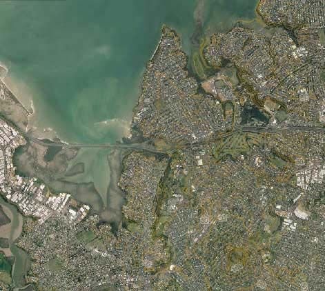
landscape professionals also embrace the model of viewing vegetation in a city as an
Urban Forest.

Parks are an important and varied category of landscape architectural production,
celebrating the use of planting and landform and creating open space, distinguishing it
from its urban or developed surroundings. Although as a ‘type’ of landscape the park has
an ancestry that is many centuries’ old, public urban parks gained significance during the
nineteenth century. providing public open space in cities. Frederick Law Olmstead
designed public parks like New York’s Central Park and Boston’s “Emerald Necklace’ of
connected linear ‘parkways’ to provide nearby nature for human recreation as well as
ecological services such as water management and wildlife habitat etc. This began the
transition from the English landscape style park with a focus on aesthetics to parks with a
stronger emphasis on ecological function.

More recently parks have become understood to be part of the spatial network of open
green space and vegetation which makes up the urban forest, with many functions,
including pollution and storm water absorption, air cooling, ecological habitat and as
access corridors, as well as human psychological and recreation benefits.

Ecologists and landscape planners contribute to understanding this spatial aspect with
the Urban Ecology model by proposing that urban vegetation may be understood as a
matrix of paths and corridors which ideally provide connectivity across a city for birds and
other fauna, and indeed people to move through, providing linkage for recreation and
access options. In pure ecology models, native vegetation is privileged in achieving
biodiversity goals, but in urban ecology, conservation and human use values are
recognised, and so both native and exotic vegetation is acknowledged (Cook, E.A. & Van
Lier, 1994: Meurck, 2003). Technological advances in fields of satellite imagery,
Geographic Positioning Systems (GPS and Geotagging), Geographic Information
Systems (GIS), QR coding and online database systems all contribute to the ability of
landscape architects and planners to analyse potential for ecological linkage in the
patterns found across urban forests.

The importance of environmental, ecological, social and psychological values and
functions of vegetation in urban areas, which are well documented (Chiesura, 2004;
Chapan & Reiss, 1992; Costanza & Daly, 1992; Given, 1994; Groombridge, 1992;
Kaplan, 1992, Relf, 1992), demand that landscape professionals plan, develop and
manage urban forest resources for quality of life and general liveability of cities. This
requires a multidisciplinary approach to the urban forest resource.

Aspects of Auckland’s Urban Forest have recently been described by a number of
authors (Cameron et al., 2008; Cliffin, 2001; Wilcox 2012). These authors draw on theory
developed by American authors such as Miller (1988) and Grey (1996), and also
describe the wide variety of ecosystem types represented in the region, and their spatial
relationships and patterns.

At Unitec’s Mt Albert campus, students, staff and the public use and value the park like
grounds. This paper aims to analyse the particular values and functions, which the
campus has in its wider context, and then propose retrofitting strategies to transition the
campus from its 19th century park character, by design interventions and management
which draw from urban ecological models to enhance its urban forest function.
Findings:
History
Mt Albert is a central suburb of Auckland with its own volcanic cone Maori called
Owairaka, probably after Wairaka who was a princess who settled nearby (Cameron et
al, 2008). The Unitec campus is influenced by lava from Owairaka, which flowed over the
campus and rock can be seen clearly where cutting was done to construct the campus
ring road at the south of the campus and as outcrops on the western edge of campus.
The rest of the site has sedimentary clay soil. Oakley Creek flows along the western
campus boundary, and sports the only urban waterfall in the Auckland Isthmus. There is
also a natural spring near the middle of campus and a constructed wetland pond system
which both flow into Oakley Creek. Runoff from the campus therefore has a direct impact
on Owairaka Spring and Oakley Creek, and subsequently into the Whau estuary.
In its history the site has had Maori occupation by Wairaka’s tribe settling from Tauranga.
Following this the land was farmed in the late 19th and early 20th century. The land was
then purchased by the government for a psychiatric hospital, with farming and
horticulture practices being important to provide food for the patients and staff. Water
was pumped from the spring for hospital and farm use by a substantial pumping station
built in 1904 (Truttmann, 2007). The grounds were designed to follow 19th century ideas
of therapy for patients as well as control over them, as described by Jeremy Treadwell
(1998). These ideas manifest in the grounds being planted and maintained by patients,
for hospital food supplies and as a park with fresh air, planting of gardens and views for
patient therapy. Historical photos show an orchard, grape vines and amenity trees
planted near the main Carrington Hospital block. Since then, the hospital was closed
down in the 1980s, and the land transferred to Unitec Institute of Technology, for
educational purposes (Unitec, 1994).
Remnants of each of these eras are still visible on the site, with Wairaka’s spring, the
pump house, remnant shelter belts and volcanic scoria dry stacked walls, heritage
buildings, large amenity trees and large open lawn areas and the more recent (late 20th
century) wetland pond system being strong features.
In considering retrofitting the Unitec campus, it is useful to consider the models its design
was originally based on. In its transition from farm to hospital grounds, principles of park
design would have been used to plan planting and landform to create an open park- like,
therapeutic landscape, which contrasted busy urban city environments (Treadwell, 1998).
Sustainable campus framework:
The context and uses of Unitec campus described above demonstrate potential for
design and management of both biological and human use components of the campus.
Unitec’s sustainability policy approved in 2011, has provided impetus for the
consideration of campus environmental planning and management, and has provided
funding for several research projects, including the Unitec Arboretum. Goals for these
projects include:
Water Shed Management
An important aspect of the role of trees and plants on campus is their role in water
management on site. 19th century park design, with groves of specimen trees and large
areas of grass do not work effectively as storm water infrastructure. Both artesian and
storm water flows across campus to end up in Oakley Creek and then the estuary at thenorth west corner of campus. Plants all across campus play a role in this filtering of
sediments and pollutants, but most importantly the plants along Oakley Creek and in the
storm water retention ponds and waterways. The storm water retention project, designed
by Isthmus Group Landscape Architects and implemented in the 1990s has played an
important role in removing sediment from run off from campus carparks, but now requires
dredging to ensure ongoing high water quality outflows to Oakley Creek.
Green Network – Urban Forest – Green Infrastructure
Unitec may be understood as a large area of green space in the city, which links to
‘corridors’ along Oakley creek and transport corridors such as paths, roads, motorway
and the railway. This Green Network may be seen as part of the Urban Forest of
Auckland, which includes all vegetation on public land, reserves, street trees and private
gardens. By linking cycle and pedestrian ways through campus it can contribute to a
‘liveable’ or ‘walkable city’ concept. Improvements to safety aspects of campus,
particularly in the valley of the Oakley Creek walkway are also important considerations
for enhancing public use.
Ecological / Biodiversity
The Auckland urban area is flanked by two large tracts of native forest, found in the
Waitakere and Hunua ranges. Habitat connections for bird and insect fauna could be
strengthened between these forests, by planning enhancement of, and increased
connectivity between large green open spaces, such as the Unitec campus, its
neighbouring parks, and other urban forest components. Development of further tree
plantings for the arboretum and riparian planting of Oakley Creek will also contribute to
the ecological function and carbon sequestering capacity of the campus.
Recreation
The campus provides a generous recreational facility in the Mt Albert community for
walking, cycling, learning to drive, orienteering etc. There are opportunities to interpret
and improve access and mapping of these opportunities, particularly in regards to
walking and cycling routes.
Education
Unitec has an impressive range of natural and cultural features on campus, which could
be better interpreted for its staff, students and wider community. These include the tree
collection, storm water retention pond system, Oakley Creek, Maori history and culture in
the Wairaka spring and the Unitec Marae, flax and cabbage tree collections, food forest,
hortecology sanctuary, and the specialist interest group activities such as apiary club
beehives, Project Crimson etc. We pride ourselves on ‘real world learning’ at Unitec, and
yet could make much more use of the campus for teaching purposes. Again
interpretation, such as a visitor’s guide and interactive map on the Unitec website would
be an ideal resource for all current and potential users of the campus grounds. Links with
community interest groups using the campus must be continued and strengthened,
particularly those which support sustainability goals such as increasing biodiversity,
restoration planting, food production and soil management. Sustainable waste
management and energy consumption systems on the campus could also be highlighted
to the public.
Spatial Factors
The Unitec campus is located in Mt Albert, close to a large number of open green
spaces, including Chamberlain golf course, Western Springs Park, the Auckland Zoo,sports grounds and the Museum of Transport and Technology (see Fig 1. below). The
western edge of the campus is bordered by the Oakley Creek Reserve, which is both a
vegetated riparian corridor and public walkway, with access from the campus to Great
North Rd. The northern edge of the campus links to the North West cycleway associated
with the motorway transport corridor.
Figure 1. Satellite image of Unitec campus in its wider Urban Forest context.
Public walkways and cycleways border the campus on east and west boundaries, linking
to major arterial and motorway transport corridors, with a new motorway extension tunnel
planned for the western boundary under great North Rd. The western rail corridor is also
nearby the eastern boundary with Carrington Rd. Members of the public use the site for
fitness and pleasure walking, dog walking, cycling and driving lessons. Interest groups
use the site for activities such as orienteering, bee keeping, community gardening etc.
There is also a Friends of Oakley Creek conservation group. These community uses of
the campus contribute to the ambience / liveability of Mt Albert as a suburb and Unitec as
a campus.
Project Outcomes – Unitec Arboretum:
Student design concepts
As part of the Bachelor of Landscape Architecture second year studio programme,
students were asked to develop design strategies for the Unitec campus. The brief
included the design of a new pedestrian / cycle path from the North to South end of
campus, and to consider how the campus could operate more effectively in the Urban
Forest of Auckland, with particular emphasis on tree plantings to develop the Arboretum.
A range of student design concepts have been presented, showing a range of possible
design strategies, which Unitec could develop, including developing plantings designed
to provide food and habitat for bird species, large orchard plantings, plantings based on
historic associations and memory and signature plantings based on the wind conditions
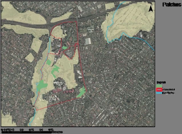
in particular parts of campus.Urban ecology
Unitec’s role in providing ecosystem services would be further enhanced if areas of 19th
century park lawn and specimen trees were redesigned to meet the criteria of an
‘ecological patch’.
Fig 2. Student ecological analysis for the Unitec Arboretum.
Key considerations for ecological criteria are increasing size of vegetated areas with
understorey planting to provide cover as habitat for both native and exotic species
biodiversity, food and habitat opportunities for birds and insect fauna (see Fig. 2). This
will increase functions such as air purification, water shed management, temperature
moderation.
These patches also have potential to link to corridors of street trees, residential gardens,
nearby open space and parks, transport and extensions of the Oakley Creek waterway.
An associated project by another Unitec researcher is to develop a strategy to enhance
the ecological values of the waterways on campus.
Arboretum development
Through the recently approved Unitec sustainability policy, this project sought to answer
the research question - How can the Unitec campus and tree collection be developed into
a sustainable arboretum.
An arboretum is a well-tended park displaying a wide range of managed tree species, which
are documented, labelled with their botanical names and intended at least partly for scientific
study. It may be a stand-alone entity, or part of a botanic garden, which would have an
associated library and herbarium of pressed samples.
There is potential identified for the existing tree collection and campus environs to gain
an increased community / public profile if developed into an arboretum. This is discussed
under four headings below:
Documentation
Ten years ago an asset management system was developed for Unitec, including an
initial survey of tree species was undertaken as part of the implementation. Landscapestudents are now updating the database as part of their course work, and the data has be
converted into a map of trees suitable for visitors, staff and students interested in taking a
campus tour. New technologies such as GPS, Geotagging and QR codes provide tools
for mapping, and for promotion and interpretation of the campus arboretum resource.
Interpretation
Interpretation of the Arboretum for staff students and the public requires a multi pronged
approach. First the Unitec library is extending its collection of reference books on trees,
and this is being further strengthened with online resources to ensure it is up to date and
accessible to visitors.
Secondly tree labels have been designed and 100 labels are to be installed to enable
staff, students, and visitors to identify the tree species, common name and origin of
Unitec’s top 100 trees. This will be expanded in the future.
Thirdly a website is under development (see Fig. 3 below), including a brief history of the
campus and its trees, and an online visitor’s guide to the arboretum. This material will be
integrated into the main Unitec website, linking to the database and including an
interactive map and photos of some of the more notable campus trees. A launch function
for the Arboretum could be used to engage key Unitec stakeholders and community,
increasing the potential for community knowledge and involvement in the Unitec campus
project.
Figure 3. Unitec Arboretum website (in development)
Planting
New plantings are being proposed to enhance the existing collection both for ecological
function and in particular themes, and to replace trees reaching senescence, developing
both species diversity and specialisations eg monocots, gondwana tree species,
ecosystem selections.
Management of trees on campus is able to be linked to the asset register database, but
at present grounds staff are not utilising it to its full potential to plan and record tree
planting, management and maintenance.Reflection
Consideration of Urban Forest and Urban Ecology models has provided new insights and
richness to the landscape design process for considering the Unitec campus. As a 19th
century park, the campus is well regarded by staff and students. However the reappraisal
outcomes discussed for the campus provide new contributions and potentials for the
wider Auckland urban forest. The complex relationship between the park and its
surroundings, and the processes by which the park came into being has proved valuable
for the Unitec campus, where the retrofitting of site elements and plantings show
potential to transform the spatial relationships between the campus and its surroundings.
The redefined Unitec Arboretum will contribute to Unitec’s goals for a sustainable
campus environment, by enhancing the ecological and social values of the campus and
its trees, and increasing public participation and identification with the Unitec campus.
Acknowledgements:
Support for this paper is acknowledged from Unitec Institute of Technology Sustainability
fund, Faculty of Creative Industries and Business, and the Department of Landscape
Architecture.
References:
Cameron, E., Hayward, B. & Murdoch, G., 2008. A field guide to Auckland. Godwit, Auckland.
Chiesura, A., 2004. The role of urban parks for the sustainable city. Landscape and Urban
Planning 68 (2004) 129–138.
Cliffin, P., 2001. Tree Collections of Auckland: Biodiversity and Management. Unpublished thesis,
MAppSc, Massey University.
Cook, E.A. & Van Lier, H.N., (Eds.) 1994. Landscape Planning and Ecological Networks.
Elsevier, Amsterdam.
Grey, G., 1996. The Urban Forest : Comprehensive Management. Wiley, New York.
Konijnendijk, C.C., 1997. A Short History of Urban Forestry in Europe. Journal of Arboriculture
23(1):31 January 1997.
Miller, R.W., 1988. Urban Forestry: Planning and Managing Greenspaces. Prentice Hall, New
Jersey.
Meurk, C.N., 2003. Cities are Cultural and Ecological Keys to Biodiversity Futures. In
proceedings of the RNZIH conference Greening the City: Bringing Biodiversity Back into
the Urban Environment. Proceedings of a conference held by the Royal New Zealand
Institute of Horticulture in Christchurch, 21-24 October 2003.
Salmond, J., 1994. Former Carrington Psychiatric Hospital : a conservation plan. UNITEC
Institute of Technology, Registry of Works, Auckland.
Scott, D., 1983. In Old Mt. Albert. Southern Cross Books, Auckland.
Truttman, L.J., 2007. Wairaka’s Waters: The Auckland Asylum Springs.Treadwell, J., 1998. Therapeutic Landscapes. Society of Architectural Historians, Australia and
New Zealand. Conference, Melbourne. (pp. 389-397) Eds: J. Willis, P. Goad, A. Hutson ;
"SAHANZ".
Unitec, 1994. A Building Known as Carrington. Unitec Press, Auckland.
Wilcox, M.D. 1996. Trees and shrubs of Unitec campus Auckland. Report published by Groome
Poyry Ltd, Auckland.
Wilcox, M.D. 2012. Auckland’s remarkable urban forest. Auckland Botanical Society Inc.,
Auckland.
List of Illustrations:
Figure 1. Satellite image of Unitec campus in its wider Urban Forest context.
Figure 2. Student ecological analysis for the Unitec Arboretum.
Figure 3. Unitec Arboretum websiteYou can also read