Climate Adaptation Action Plan - HAWAII HIGHWAYS - HAWAI'I DEPARTMENT OF TRANSPORTATION - Hawaii Department of ...
←
→
Page content transcription
If your browser does not render page correctly, please read the page content below
HAWAI‘I DEPARTMENT OF TRANSPORTATION
                      HIGHWAYS DIVISION

                                    HAWAII HIGHWAYS
       Climate Adaptation Action Plan
                       Strategies for a More Resilient Future

May, 2021
                                      HAWAII HIGHWAYS   C L I M AT E A D A P TAT I O N A C T I O N P L A N   1
A Message from Ed Sniffen,
                                               Deputy Director of the Highways Division

            Aloha,
            Hawai‘i is resilient and self-sufficient. From its very        how changing environmental conditions will likely
            first inhabitants, decisions and actions have been             impact the State’s highway network in the future. It
            made to accommodate, adapt, and thrive with nature.            outlines numerous strategies to ensure that today’s
            For thousands of years, environmental conditions in            decisions reflect future long-term environmental risks
            Hawai‘i and worldwide have been relatively stable.             so that every decision and action we make is one that
            But such conditions are now changing. Global average           achieves greater network resilience.
            temperatures are increasing; sea levels are rising; and
                                                                           The Action Plan presented in this report identifies the
            in many parts of the world storms are becoming more
                                                                           data used by HDOT staff in designing and managing
            frequent and intense.
                                                                           State highways and how this data, combined with
            These changing conditions have important implications          the additional climate data shown as required in the
            to Hawai‘i – inundated shorelines, coastal erosion,            plan, can be used to guide future decisions. It focuses
            floods from rainfall, a higher water table, more               on ways to change key procedures and agency
            saturated soils and greater risks of landslides, and           capabilities to be better prepared for climate change.
            increased wildfires. Given our understanding of what           The success of the Action Plan requires collaboration
            is changing, we need to make some tough decisions              with many other agencies and groups that are critical
            to ensure the long-term viability of the State. It no          to the State’s economy and community. Hawai‘i’s
            longer makes sense to continue the same approaches             community fabric is deeply interwoven, and actions
            we have been using to maintain and improve the                 taken by HDOT need to be mindful of the critical need
            State Highway Network, which assume historic                   for effective transportation options. Such essential
            environmental conditions will remain unchanged.                collaboration will ensure that future generations will
            The Highways Division of the Hawai‘i Department of             benefit from the actions HDOT takes today.
            Transportation (HDOT) needs to be more resilient,
                                                                           This Action Plan reflects the input of the professionals
            adaptive, and engaged in climate change risks to our
                                                                           who work at HDOT, their thoughts on how to best
            highway network. It is our responsibility.
                                                                           proceed and change the way they do business to
            This Action Plan is our first step to act comprehensively      better incorporate resilience into everyday practices.
            across the agency in recognizing and considering               We will work diligently with our partners to ensure the
            more fully these changing climatic conditions. The             long-term viability of Hawai‘i for the generations to
            Plan is based on research and studies conducted                come. Thank you for your support.
            by other agencies to establish an understanding of
                                                                           Mahalo,
                                                                           Ed Sniffen

2   HAWAII HIGHWAYS   C L I M AT E A D A P TAT I O N A C T I O N P L A N
CONTENTS                                                FIGURES
                                                      Figure ES- 1 The Basic Framework for Achieving
A MESSAGE FROM ED SNIFFEN,
                                                                   System Resilience                                              5
DEPUTY DIRECTOR OF THE HIGHWAYS DIVISION          2
                                                      Figure ES-2 Climate Exposure Summary
EXECUTIVE SUMMARY                                 4               by Stressor                                                     6
    Background                                    4   Figure 1        Current Practice vs
    Exposure Assessment Findings                  4                   Future Resilience Practice                                  11

    Next Steps                                    5   Figure 2        Risk Mitigation Approach                                    11
    Climate Exposure Summaryby Stressor           6   Figure 3        Kamehameha Highway Repairs at
    Vision                                        8                   Ka‘a‘awa, O‘ahu                                            12
    Purpose of this Action Plan                   8   Figure 4        2018 Landslides on Kūhiō Highway,
                                                                      North Shore Kaua‘i                                         13
INTRODUCTION                                      8
                                                      Figure 5        Selected Repairs Sites on HDOT-
    Who Should Read this Action Plan?             9                   Highways Roads Associated with
    Action Plan Organization                      9                   Emergencies Since 1997                                     14

THE URGENCY: WHY WE MUST ACT AND                      Figure 6        Assessment Steps Toward Prioritized
CHANGE CURRENT PRACTICES                         10                   Action                                                     15

    The Need for a Resilient Highway System      10   Figure 7        Conceptual Collaboration Framework
                                                                      for Implementation                                         17
    A Future Unlike the Past                     10
    A Proactive Perspective on Mitigating Risk   11   Figure 8        Resilient Design Process                                  24
    Examples of Past Events                      12   Figure 9        Concerns to be Addressed Through
    Hazards Examined in this Action Plan         14                   Data Assembly/Development                                 25
    Moving Toward Prioritized Investments        15
    Partnerships in Implementation               15
    Response and Recovery                        18
                                                                            TABLES
IMPLEMENTATION PLAN                              18
                                                      Table ES- 1     Mileage of HDOT Highways
    Maintenance Programs                         19                   Exposed to Climate Hazards
    Data-driven Decisions                        19                   (to 3.2 feet SLR)                                           5
    Design/Mitigation                            19   Table 1         Exposure Assessments                                       14
    Planning/Programming                         20
    HDOT Lead/Resources                          21
    Training                                     22
    Partnerships                                 22

NEXT STEPS
    Investing for Effective Design When
      Considering Climate Change                 24
    A Data-driven Resilience Program             25

REFERENCES                                       26

APPENDICES

                                                                HAWAII HIGHWAYS   C L I M AT E A D A P TAT I O N A C T I O N P L A N   3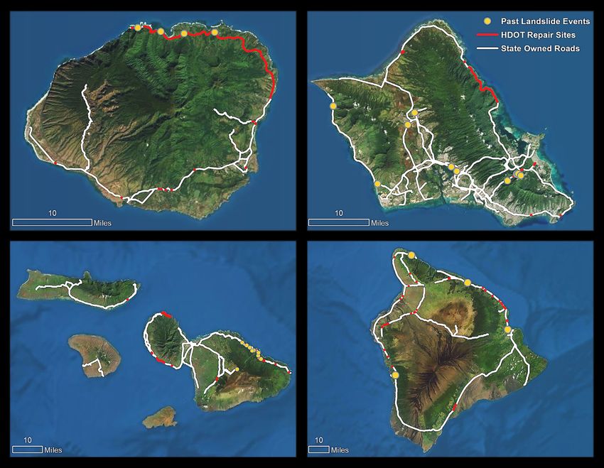
Executive
      Summary
        BACKGROUND                                                         agencies; utilities; communities, and businesses. HDOT is
                                                                           committed to working with all stakeholders in addressing the
        Changing climatic conditions are creating challenges for           shared climate change challenges.
        Federal, State, and local government agencies throughout
        the United States. Hawai‘i is experiencing such challenges,
        which are in many cases unique to the Hawaiian Islands. The
                                                                           EXPOSURE ASSESSMENT
        Highways Division of the Hawai‘i Department of Transportation      FINDINGS
        (HDOT) recognizes its responsibility to better understand how
                                                                           The hazards examined in this study are summarized in Table ES-1,
        changing climate conditions could impact the State’s portion
                                                                           Figure ES-2, and fully described in the Exposure Assessment
        of the National Highway System (NHS). The Hawai‘i Highways
                                                                           document that was prepared as a companion document to this
        Climate Adaptation Action Plan (Action Plan) helps HDOT better
                                                                           plan. A map identifying specific areas of concern is presented
        define the extent and timing of these changing conditions on
                                                                           over the following pages. The State Highway Network was the
        NHS facilities. Specific actions are identified on how climate
                                                                           focus of this study. Of the total mileage, 564 miles (58% of the
        change concerns can be considered and acted upon throughout
                                                                           network) are exposed to potential climate change stresses and
        HDOT’s programs, ensuring the viability of the highway system
                                                                           lava flows (16% is attributable to lava flows) including 303 bridges
        for Hawai‘is residents, visitors, communities, and businesses.
                                                                           (76% of the assessed bridges), 48 culverts (66% of the assessed
        HDOT is responsible for the condition and performance of           culverts), and 6 tunnels (100% of the assessed tunnels). Note that
        approximately 971 (linear) miles of highways on 6 islands          lava flows are not climate-related hazards but were considered
        within the State. The effective management of these NHS            in a broad approach to increase highway network resilience. The
        highways is a top priority for HDOT because of their vital         mileage and assets exposed to each stressor, in some cases
        contribution toward community access, economic prosperity,         overlapping with other hazards, are presented below.
        national security, and overall mobility. The Action Plan
                                                                           Each of these conditions, except for lava flows as noted, is
        provides a roadmap for HDOT’s Highways Division to make
                                                                           anticipated to be affected by climate change in Hawai‘i. It is
        the highway system more resilient to climate-related effects.
                                                                           important to think not only about past experience with such
        It presents an exposure assessment of climate hazards to
                                                                           hazards, but also the anticipated changes that could alter the
        the State’s highways based on both historical and future
        climate condition research and data. The Action Plan
        prioritizes recommendations in a multi-year Implementation
        Plan that encompasses all aspects of HDOT’s core functions
        and programs—funding, planning, designing, constructing,                This document is one of two resources that
        operating, maintaining, and protecting highway assets. It is            outlines the potential threats from climate
        considered a living document and will be revised as needed to           change to Hawai‘i Highways. This Plan is a
        reflect changes in conditions and implementation status.                companion to the online mapping platform
        The intended audience is primarily HDOT management and                  maintained on HDOT’s website to enable the
        staff but also includes Federal, State, and local agencies and          review of climate threats at a level of detail
        government leaders; other county, city, and local governmental          not possible in printed form. That site is
                                                                                located at: https://hidot.hawaii.gov/
4   HAWAII HIGHWAYS   C L I M AT E A D A P TAT I O N A C T I O N P L A N
Re-examine Future                   Re-examine
                       Conditions based                    Uncertainties
                       on New Science                      and Risks based
                       and Data                            on Experience

                                           Consider                         Develop                                               Achieve
                 Look                                                     Information                  Invest
                Forward                  Uncertainties                                                                            System
                                                                           Needed to                   Wisely
                                           and Risk                     Support Decisions                                        Resilience

    Figure ES- 1 The Basic Framework for Achieving System Resilience

intensity and character of their impact on Hawai‘i. In establishing                  integrating considerations of climate risk and long-term climate
this baseline understanding of future change, HDOT can take                          change resiliency into agency practices.
the necessary project development and investment steps to                            Finally, this Action Plan also outlines needed next steps for
increase the overall resilience of the highway system.                               HDOT in terms of further actions required to provide more
Temperature and precipitation variability and extremes                               definition to the risks to assets. Additional analysis is needed to
expected from climate change can accelerate damages to                               fully understand asset consequences and impacts from climate
pavement, structural support, underground infrastructure, and                        and environmental hazards studied. More detailed assessments
stormwater conveyance when combined with regular use.                                are needed in some cases to determine the appropriate
The result is more frequent maintenance and repair, as well as                       responses. HDOT will also move forward with the immediate
reduced lifecycle requiring earlier replacement. The effects of                      and near-term actions outlined in the Implementation Plan.
these conditions will be further defined through subsequent                          Implementing these actions will increase HDOT awareness
work, along with additional hazards such as inland flooding for                      of climate change impacts, encourage internal and external
which data was not currently available.                                              communications regarding data collection, incorporate
                                                                                     resilience as a required element of HDOT’s internal design and
                                                                                     operational procedures, and promote budgets that reflect the
NEXT STEPS                                                                           reality of climate change impacts.
A key consideration discussed throughout the Action Plan                             HDOT has already been working toward creating a resilient
is the need for HDOT to change internal practices to drive                           highway system to serve the communities and businesses of the
more future-oriented decisions and designs to ensure the                             Hawaiian Islands, such as integrating potential climate hazards
long-term success of the NHS. For example, most climate                              into HDOT’s Transportation Asset Management Plan (TAMP),
adaptation studies in the U.S. use future climate projections                        the use of an adaptive design framework in the Waipa and
rather than relying on historical conditions, which has been                         Waikoko bridge repair project on Kaua‘i to withstand a tsunami
the standard in state departments of transportation.                                 hazard, and the preparation of a Statewide Coastal Highway
Figure ES-1 above identifies the general approach for                                Program Report in 2019 (Francis et al. 2019). The Action Plan
achieving highway network resilience—starting with a forward                         presents additional opportunities for HDOT to better understand
look at possible future risks to the highway network leading                         the implications of changing climate conditions on agency
to cost-effective investments that lead to a more resilient                          assets. It is focused on adjusting internal practices within the
highway system.                                                                      agency to ensure that all decisions made from this point forward
                                                                                     are mindful of expected future climate change conditions.
This Action Plan identifies recommendations focused on different                     The ultimate result of this Action Plan will be to increase the
functions of the HDOT Highways Division with the end goal of                         resilience of the highway system to existing and future risks.

        Table ES- 1 Mileage of HDOT Highways Exposed to Climate Hazards (to 3.2 feet Seal Level Rise (SLR)

                                                          Roads                  Bridges                   Culverts                   Tunnels

          Hazard                                  Miles           %          Units          %        Units            %         Units             %

          Rockfall and landslide                  167.6           17%         126          32%         11             15%         6            100%
          Sea Level Rise                           9.4            1%           92          23%         7              10%         0              0%
          Annual high wave flooding               23.9            2%           50          13%         6              8%          0              0%
          Coastal erosion                          23.7           2%           22          6%          2              3%          0              0%
          Storm surge                              74.1           8%          120          30%         9              12%         0              0%
          Tsunami                                 178.1           18%         135          34%         15             21%         0              0%
          Wildfire                                139.2           14%          97          24%         18         25%             0              0%
          Lava flow                               151.8           16%          18          5%          15             21%         0              0%

          3.2 feet used for the summary utilizing values from the Hawaii Sea Level Rise
          Vulnerability and Adaptation Report (2017)
                                                                                                        HAWAII HIGHWAYS     C L I M AT E A D A P TAT I O N A C T I O N P L A N   5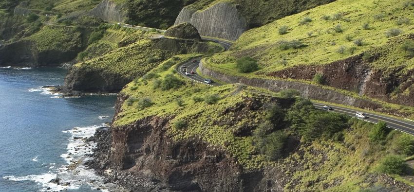
FIGURE ES-1:
                                                                                   CLIMATE EXPOSURE SUMMARY
                                                                                   BY STRESSOR

     CLIMATE
     STRESSOR            Rockfalls and Landslides
     EXPOSURE            Segments associated with sites prioritized in
     ASSESSMENT          HDOT’s Rockfall Protection Program and sites
                         determined to have high and very susceptibility
                         according to USGS
     ROADS EXPOSED
     [MILE]        167.6 miles

     EXAMPLES            • Kaua‘i District: portions of Kūhiō Highway in
     OF EXPOSED            Hanalei and near Wainiha; Waimea Canyon
     AREAS                 Road and Koke‘e Road
                                                                               CLIMATE
                                                                               STRESSOR             Annual high wave flooding
                         • O‘ahu District: portions of Farrington Highway
                           near Mākua Beach and Nānākuli; along Likelike       EXPOSURE            Segments exposed to annual high wave flooding considering three sea level
                                                                               ASSESSMENT          rise scenarios
                           Highway and Pali Highway; along Kalaniana‘ole
                           Highway in Waimānalo                                ROADS EXPOSED 2.8 miles (0.5-ft SLR), 4.2 miles (1.1-ft SLR), 9.5 miles (2.0-ft SLR),
                         • Maui District: Hāna Highway in East Maui;           [MILE]
                                                                                             and 23.9 miles (3.2-ft SLR)
                           portions of Honoapi‘ilani Highway in West Maui
                         • Hawai‘i District: Māmalahoa Highway on              EXAMPLES            • Kaua‘i District: portions of North, West, and East Kaua‘i, including Kūhiō
                           Hāmākua Coast                                       OF EXPOSED            Highway between Hanalei and Wainiha; Kaumuali‘i Highway in Kekaha/
                                                                               AREAS                 Waimea; Kūhiō Highway over Wailua River and through Kapa‘a
                                                                                                   • O‘ahu District: portions of of Kamehemaha Highway on the North Shore
     CLIMATE
     STRESSOR             Sea Level Rise                                                             and Windward shore (Kualoa to La‘ie); Ala Moana Boulevard; Kalaniana‘ole
                                                                                                     Highway in Hawai‘i Kai and Waimānalo
     EXPOSURE            Segments exposed to marine flooding and                                   • Maui District: portions of Honoapi‘ilani Highway in West Maui
     ASSESSMENT          groundwater inundation considering three sea                                (Lahaina to Olowalu); North Kihei Road by Kealia Pond
                         level rise scenarios

     ROADS EXPOSED 3.2 miles (0.5-ft Sea Level Rise (SLR)), 3.4 mile (1.1-ft
     [MILE]
                   SLR), 4.1 mile (2.0-ft SLR), and 9.4 miles (3.2-ft SLR)
                                                                               CLIMATE
                                                                               STRESSOR              Coastal erosion
                                                                               EXPOSURE             Segments exposed to coastal erosion considering three sea level
     EXAMPLES            • Kaua‘i District: portions of North, West, and       ASSESSMENT
     OF EXPOSED                                                                                     rise scenarios
                           East Kaua‘i, including Kūhiō Highway between
     AREAS                 Hanalei and Wainiha; Kaumuali‘i Highway in          ROADS EXPOSED        8.4 miles (0.5-ft SLR), 12.1 miles (1.1-ft SLR), 17.9 miles (2.0-ft SLR),
                           Kekaha/Waimea; Kūhiō Highway over Wailua            [MILE]
                                                                                                    and 23.7 miles (3.2-ft SLR)
                           River and through Kapa‘a
                         • O‘ahu District: portions of Farrington Highway      EXAMPLES             • Kaua‘i District: portions of North, West, and East Kaua‘i, including Kūhiō
                           on the Wai‘anae Coast; Kamehemaha Highway           OF EXPOSED             Highway between Hanalei and Wainiha; Kaumuali‘i Highway in Kekaha;
                           on the North Shore and Windward shore               AREAS                  Kūhiō Highway by Wailua River and Kapa‘a
                           (Kahana to Kahuku), Sand Island and Ala Moana                            • O‘ahu District: portions of Farrington Highway on the Wai‘anae Coast;
                           Boulevard; Kalaniana‘ole Highway in Hawai‘i Kai                            Kamehemaha Highway on the North Shore and Windward shore
                         • Maui District: North Kihei Road by Kealia Pond;                            (Kualoa to La‘ie), Kalaniana‘ole Highway in Waimānalo
                           portions of Kamehameha V Highway on south                                • Maui District: portions of Honoapi‘ilani Highway in West Maui
                           coast of Moloka‘i                                                          (Lahaina to Olowalu); North Kihei Road by Kealia Pond

    Notes - More detailed information on locations of concern can be found in the on-line map viewer prepared to accompany this document
          - Sea Level Rise summarizes infrastructure inundated directly by sea level rise or groundwater rise

    Source: State-Owned Roads: HDOT Highways Division, LRMS; Base maps: Esri, DigitalGlobe, GeoEye, Earthstar Geographics, CNES/Airbus DS, USDA, USGS, AeroG-
    RID, IGN, and the GIS User Community; World Ocean Reference: Esri, GEBCO, NOAA, National Geographic, Garmin, HERE, Geonames.org, and other contributors

6     HAWAII HIGHWAYS    C L I M AT E A D A P TAT I O N A C T I O N P L A N
CLIMATE
STRESSOR        Storm surge                                                                    CLIMATE
                                                                                               STRESSOR        Tsunami
EXPOSURE                                                                                                       Segments exposed to historical (1946, 1952, 1957,
                Segments exposed to storm surge due to hurricanes of Categories 1 through 4
ASSESSMENT                                                                                     EXPOSURE        1960, and 1964) and hypothetical tsunamis (two
ROADS EXPOSED 74.1 miles                                                                       ASSESSMENT      great Aleutian earthquakes with moment magni-
[MILE]                                                                                                         tudes of 9.3 and 9.6)
EXAMPLES        • Kaua‘i District: portions of North, West, and East Kaua‘i, including Kūhiō   ROADS EXPOSED 178.1 miles
OF EXPOSED        Highway between Hanalei and Wainiha; Kaumuali‘i Highway in Kekaha/           [MILE]
AREAS             Waimea; Kūhiō Highway over Wailua River and through Kapa‘a                                   • Kaua‘i District: portions of North, West, and East
                • O‘ahu District: portions of Farrington Highway on the Wai‘anae Coast, Ewa                      Kaua‘i, including Kūhiō Highway between Hanalei
                  Beach, areas of Kamehemaha Highway on the North Shore and Windward                             and Hā‘ena; Kaumuali‘i Highway in Kekaha/
                  shore (Kualoa to La‘ie); Sand Island , Nimitz Highway, and Ala Moana                           Waimea; Kūhiō Highway over Wailua River and
                  Boulevard; Kalaniana‘ole Highway through Hawai‘i Kai                                           through Kapa‘a
                • Maui District: portions of Honoapi‘ilani Highway in West Maui (Olowalu to                    • O‘ahu District: most coastal roads of O‘ahu,
                  Pāpalaua); North Kihei Road by Kealia Pond; roads surrounding Kahului                          including Kamehameha Highway and Farrington
                  Harbor; portions of Kamehameha V Highway on south coast of Moloka‘i          EXAMPLES          Highway; Sand Island , Nimitz Highway, and Ala
                                                                                               OF EXPOSED        Moana Boulevard; Kalaniana‘ole Highway through
                • Hawai‘i District: roads along Hilo Bay and Kawaihae Harbor                   AREAS
                                                                                                                 Hawai‘i Kai and Waimānalo
                                                                                                               • Maui District: roads in West and Central Maui,
                                                                                                                 including Honoapi‘ilani Highway and Hana
                                                                                                                 Highway to Spreckelsville/Paia; Kamehameha V
                                                                                                                 Highway on south coast of Moloka‘i
                                                                                                               • Hawai‘i District: roads along Hilo Bay and
                                                                                                                 Kawaihae Harbor

                                                                                               CLIMATE
                                                                                               STRESSOR        Lava flow
                                                                                                               Segments associated with lava flow hazard zones
                                                                                               EXPOSURE        1 through 3 on the Island of Hawai‘i and zone 1 in
                                                                                               ASSESSMENT
                                                                                                               the Maui District
                                                                                               ROADS EXPOSED 151.8 miles
                                                                                               [MILE]
                                                                                                               • Hawai‘i District: portions of Māmalahoa
                                                                                               EXAMPLES          Highway/Hawai‘i Belt Road through Hilo,
                                                                                               OF EXPOSED        Puna, and Volcano area to Kailua-Kona;
                                                                                               AREAS             Queen Ka‘ahumanu Highway and Māmalahoa
                                                                                                                 Highway mauka of Waikoloa Village.

CLIMATE
STRESSOR        Wildfire
                Segments associated with 1-km2 areas where
EXPOSURE        more than one wildfire ignition occurred between
ASSESSMENT
                2000 and 2012
ROADS EXPOSED
              139.2 miles
[MILE]
                • Kaua‘i District: portions of Kūhiō Highway
                  including Līhu‘e and Kapa‘a areas
                • O‘ahu District: Leeward O‘ahu, including
EXAMPLES          Wai‘anae Coast, ‘Ewa, Pearl City, urban
OF EXPOSED        Honolulu, as well as Wahiawā and Hale‘iwa
AREAS           • Maui District: roads in Kahului, Kīhei, and
                  Lahaina areas
                • Hawai‘i District: portions of Queen Ka‘ahumanu
                  Highway on the Kona Coast

LEGEND

         Highway Asset Exposed to Climate Hazard
         Highway Asset Not Exposed to Climate Hazard

                                                                                                      HAWAII HIGHWAYS   C L I M AT E A D A P TAT I O N A C T I O N P L A N   7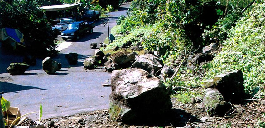
1
        VISION
                                  Introduction
        As a steward of the State’s investment in the State Highway Network, the
                                                                                        HDOT’s vision is to develop and
        Highways Division for the Hawai‘i Department of Transportation (HDOT)
                                                                                        maintain a viable and resilient
        must plan for, respond to, and recover from disruptions, including those
        associated with extreme weather events. HDOT’s policies, programs, and
                                                                                        highway system for Hawai‘i.
        day-to-day operations must consider increases in the frequency and intensity
                                                                                        HDOT’s mission is to provide a safe,
        of such events and, over the long-term, changing climatic conditions such
                                                                                        efficient, accessible, and sustainable
        as sea level rise, more frequent floods, increased rockfalls, and wildfires;
        and impacts to the public. HDOT recognizes this responsibility and will
                                                                                        intermodal highway system that
        implement the recommendations in this Action Plan to meet climate change        ensures the mobility of people
        challenges. As a member of the State’s Climate Commission and its Climate       and goods and enhances and/or
        Ready Hawaii Initiative, HDOT will also support the Commission’s efforts to     preserves economic prosperity and
        develop climate change strategies that are “clean, equitable and resilient.”    the quality of life.
        It should also be noted that HDOT’s vision includes initiatives to reduce
        greenhouse gas emissions from both HDOT and from the public to limit
        contributions to changing climate conditions. Efforts to encourage the use
        of active transportation modes, autonomous vehicles, electric vehicle fleets,
        teleworking, and many others can help to reduce emissions that contribute
        to climate change.

        PURPOSE OF THIS ACTION PLAN
        The Hawai‘i Highways Climate Adaptation Action Plan (Action Plan) provides
        a roadmap for HDOT’s Highways Division to make the highway system more
        resilient to climate-related effects. It:
        ⊲ identifies locations along the state highways that are exposed to natural
          hazards, and
                                                                                                                 Kuhio Highway   |   Wainiha
        ⊲ outlines strategies to be implemented and actions to be taken to
          incorporate resilience into its programs and policies.
                                                                                        Resilience is the ability to adapt to
                                                                                        changing conditions and withstand,
        This Action Plan prioritizes recommended actions that results in a
                                                                                        respond to, and recover rapidly from
        multi-year Implementation Plan that encompasses all aspects of HDOT’s
                                                                                        disruptions. (HDOT Highways Division
        core functions—funding, planning, designing, constructing, operating,
                                                                                        Definition 12/20/2019)
        maintaining, and protecting highway assets.

8   HAWAII HIGHWAYS   C L I M AT E A D A P TAT I O N A C T I O N P L A N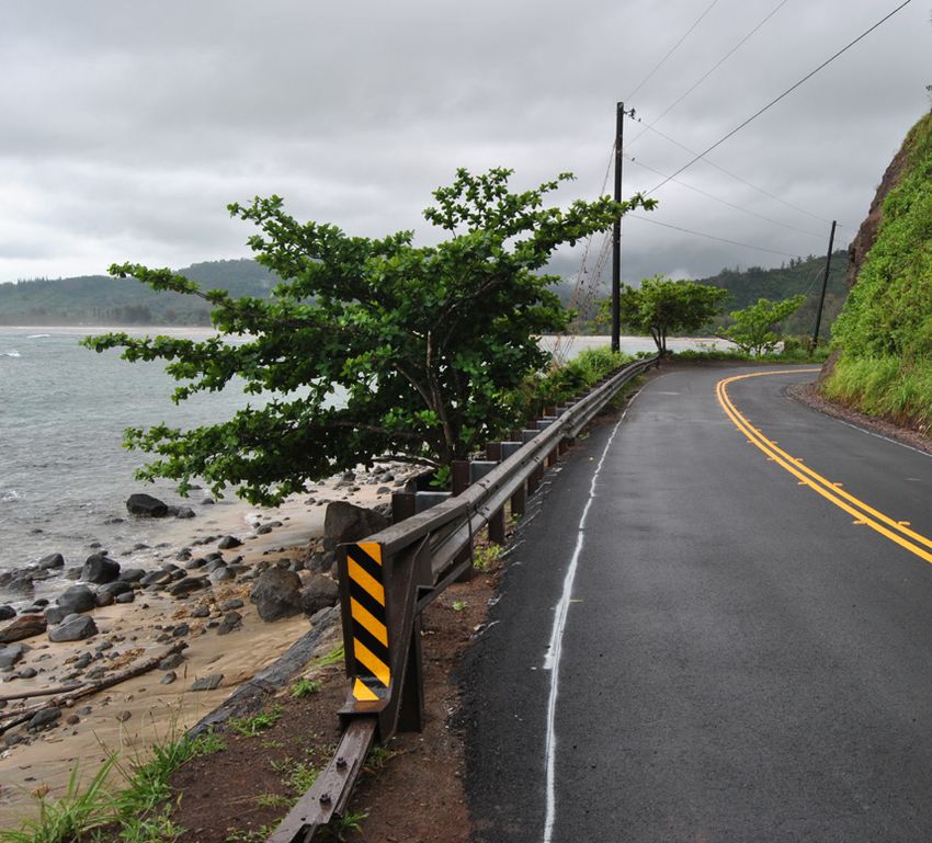
This Action Plan is a living document that will be updated        Federal, State, and local agencies and government
periodically to reflect the following:                            leaders. HDOT relies on collaboration with other agencies
                                                                  and groups that participate in project/strategy development
⊲ Highways Division progress in incorporating climate
                                                                  and implementation through such actions as providing
  adaptation and system resilience concepts and practices
                                                                  funding, issuing permits and project approvals, and
  throughout the Division, and the corresponding
                                                                  influencing public perceptions as part of building and
  performance of the highway network in response.
                                                                  operating critical infrastructure. The active participation of
⊲ New climate data produced by research institutions such         these agencies in implementing the Action Plan will be an
  as the National Oceanic and Atmospheric Administration          important factor in its success. In addition HDOT will work
  (NOAA), the U.S. Geological Survey (USGS), and the              with the Climate Commission to gain active participation of
  University of Hawai‘i. HDOT is committed to adopting            State and local agencies.
  an adaptive management framework that continuously
                                                                  Other county, city, and local governmental agencies. As
  incorporates new and evolving information. This updated
                                                                  the Action Plan was developed, it became apparent that
  current and future climate information that may be helpful
                                                                  many county, city, and local agencies are interested in how
  for transportation decisions can be reflected in the exposure
                                                                  HDOT’s actions could affect their activities and how their
  assessments via the web map viewer.
                                                                  actions might impact the activities of HDOT. It is therefore
                                                                  critical that active coordination occurs among these agencies
WHO SHOULD READ THIS                                              as the recommended actions are implemented.

ACTION PLAN?                                                      Citizens, businesses, and communities. Finally, given the
                                                                  everyday importance of the highway network to the entire
HDOT management and staff. This is the primary audience           State, the public is an important constituency for the Action
for the Action Plan. Importantly, the Action Plan highlights      Plan. They should be included in the regular communications
the branches in HDOT with primary responsibility for              of the actions that HDOT is undertaking on their behalf.
implementing the recommendations.

ACTION PLAN ORGANIZATION
The Action Plan is organized into the following sections:
⊲ Section 2 provides the general context for the needs              • Section 3.5 Planning/programming
  addressed by the Action Plan.
                                                                    • Section 2.6 HDOT leadership/resources
  • Section 2.2 outlines how decisions will need to be
                                                                    • Section 3.7 Training
    based on an understanding of future conditions.
                                                                    • Section 3.8 Partnerships
  • Section 2.3 identifies the need for a proactive approach
    to managing risks to the system.                              ⊲ Section 4 Next steps

  • Section 2.4 includes examples of past natural hazard-           • Section 4.1 outlines a process by which a scenario-driven
    related disruptions.                                              risk method can be used to make

  • Section 2.5 lists the hazards considered in this Action         • Section 4.2 describes the need for data specific to
    Plan.                                                             resilience decision-making that should become part of
                                                                      HDOT’s program
  • Section 2.6 recommends a collaborative strategy to
    achieve a resilient Hawai‘i and HDOT’s role                   ⊲ Appendix A summarizes the recommendations resulting
                                                                    from the Exposure Assessments
  • Section 2.7 discusses the importance of partnerships in
    achieving the goals of this Action Plan                       ⊲ Appendix B provides an overview of State, local, and
                                                                    Federal technical resources and guidance pertaining to
⊲ Section 3 identifies priority recommendations for
                                                                    climate change in Hawai‘i
  implementing the Action Plan by different functional areas
  and responsibilities in HDOT                                    ⊲ Appendix C describes the role and organization of
                                                                    Environmental Offices in other State DOTs
  • Section 3.1 Response and recovery
                                                                  ⊲ Appendix D provides more details on desired partnerships
  • Section 3.2 Maintenance programs
                                                                    towards implementing the Action Plan
  • Section 3.3 Data-driven decisions
  • Section 3.4 Design/mitigation

                                                                                    HAWAII HIGHWAYS   C L I M AT E A D A P TAT I O N A C T I O N P L A N   9
2                                The Urgency:
                                                Why We Must Act and
                                                Change Current Practices

         THE NEED FOR A RESILIENT                                            HDOT recognizes it is important to increase the resiliency
                                                                             of highway infrastructure by incorporating future climate
         HIGHWAY SYSTEM                                                      change considerations into HDOT project design, operations,
                                                                             maintenance, and programming and budgeting. The
         HDOT is responsible for the condition and performance of
                                                                             intended result is improved infrastructure resilience to
         approximately 971 (linear) miles of highways on 6 islands within
                                                                             climate change hazards, reduced operation and maintenance
         the State. Just over 456 miles of this network is part of the
                                                                             costs, and reduced risk to public safety.
         National Highway System (NHS). The effective management
         of these NHS highways is a top priority for HDOT because of
         their vital contribution toward community access, economic          A FUTURE UNLIKE THE PAST
         prosperity, national security, and overall mobility (HDOT 2019a).
                                                                             Climate change will result in environmental conditions that
         The configuration of the State Highway Network reflects the         are different than those historically considered as a part of
         terrain and geography of the State. Belt roadways on low-lying      transportation project development and decision-making.
         coastal areas typically encircle each island, while steep central   Transportation planning and design, like most science-based
         mountain ranges a few miles inland limit the number of cross-       technical disciplines, are dependent on research to develop
         island routes. These roadways are critical for each island given    best practices that often reflect how transportation facilities
         the limited alternatives for accessing many island communities.     have responded to historic environmental conditions. Field
         Unfortunately, this configuration makes the highway network         measurements are made, summaries are created, statistical
         especially vulnerable to natural hazards. Shoreline change,         analyses are completed, and target levels are identified on
         coastal erosion, and storm surge compromise the State’s             which to make decisions (e.g. a 50-year storm event, etc.).
         coastal highways. In addition, the roadways that pass through
         mountainous terrain are susceptible to natural weathering,
         erosion, and rockfall where the volcanic rock slopes and cliffs
         have been excavated to construct the roadways.
         Several recent extreme weather events have resulted in                     Climate change shifts the perspective from
         significant unanticipated impacts to Hawai‘i’s highways. The               past conditions as the only predictor of the
         severity and increased frequency of these events are attributed            future, to forward-looking analyses that
         to weather or climate change hazards that are not typically                consider projections of how the future could
         effectively addressed in traditional highway design methods.
                                                                                    be different. Adopting such a forward-looking
         Applied design standards are based on the analysis of past
                                                                                    perspective has proven to be one of the
         conditions; however these are proving insufficient, as many
         states nationally are coping with unanticipated risks to safety
                                                                                    greatest challenges associated with changing
         and extensive damage to highway infrastructure. Traditional                standard practice in state transportation
         design standards will need to be adjusted to address the                   agencies.
         effects associated with climate changes and better reflect
         future risks to the highway system.

10   HAWAII HIGHWAYS   C L I M AT E A D A P TAT I O N A C T I O N P L A N
Observed Analysis of Apply Design
Conditions Recurrence Policy
Based on Historical Conditions APPLIED
DESIGN Based on Estimated Future Conditions
Estimate
Design Determine Estimate Life
Changing Future
Figure 1 Current Practice vs for Risk Consequences Cycle Costs
Future Resilience Practice Conditions
Values of design input factors such as mean higher high water,
precipitation return periods, seismic risks, landslide potential, and
A PROACTIVE PERSPECTIVE ON
similar measures are determined directly from field observations MITIGATING RISK
and assessments of existing or past conditions.
Several recent extreme weather events have resulted in
Research efforts conducted through agencies such as significant impacts to Hawai‘i’s highway system, and in some
NOAA, USGS, the Federal Highway Administration (FHWA), cases, the resulting impacts caught HDOT unaware. This is
the Transportation Research Board, and the American partly because the impacts to highways were much greater
Association of State Highway and Transportation Officials than had been expected when the road was designed. It
(AASHTO) or by HDOT and the University of Hawai‘i has not been common practice to examine future possible
contribute to the body of knowledge that supports project risks to above-normal extreme weather effects. However,
decision-making. However, climate change shifts the providing resilient infrastructure that takes into consideration
perspective from past conditions as the only predictor of the expected environmental conditions is becoming a greater
future, to forward-looking analyses that consider projections concern throughout the country. HDOT recognizes that it
of how the future may be different. Adopting such a forward- does not have all the information it needs to adopt such an
looking perspective has proven to be one of the greatest approach. Efforts undertaken by others and documented in
challenges associated with changing standard practice this Action Plan present a positive first step, but more work is
in state transportation agencies. It represents a different needed at a more refined level to identify where adaptation
approach, and there are many uncertainties associated with investments are most critical and what it will take to create
the projections of climate variables, and the strategies and a highway network that is resilient to the hazards that may
designs developed in response need to be more flexible and affect Hawaii.
adaptive to changing environmental conditions. Changing
In this Action Plan, HDOT has committed to better defining the
the perspective from one that is based on historic trends and
risks from extreme weather and climate change, develop the
analyses to one that is more oriented to projected changes
information it needs to be more proactive in its assessments,
is an important underlying theme of this Action Plan. The
and take action to eliminate or reduce the impacts before
information contained in the Exposure Assessments report of
they occur (Figure 2). A key element of this effort will be to
this Action Plan outlines how future conditions are expected
take a closer look at conditions along the highway network
to be different from past conditions and thus provide a
and reduce or eliminate the unknowns and uncertainties
general basis to make future-oriented decisions.
associated with expected climate change-related hazards.
Figure 1 illustrates the different perspective that is needed
Such an effort will require a more extensive program to
to lead to better and more adaptive investment decisions
accurately define specific locations on the highway network
for transportation assets in Hawai‘i. The three gray boxes
that have considerable risk to climate change-related
leading into applied design identify how elements of risk are
disruptions and that lead to proactive adaptation investment.
determined through current practices, looking backwards in
The identification of some risks is currently being conducted
time. In contrast, the colored boxes identify the steps toward
by State partners, including the University of Hawai’i, which
incorporating a future-looking perspective. By addressing
is identifying coastal risks at a more refined level, generating
inherent uncertainties, such an adaptive approach can
data that will be helpful for HDOT in making more fully
facilitate decisions that better consider how future conditions
informed decisions. Other required data could be generated
could affect an asset and its users, resulting in better and
through collaboration with other State and Federal partners.
more resilient investments. The process for how this works
Field reviews and engineering assessments will also provide
at the project level is defined in Next Steps section of this
the necessary information required to assess the immediacy
Action Plan. Such a shift in approach is a critical capability,
of risks/impacts and the timing for when potential impacts
which is an underlying basis for much of this Action Plan.
may need to be addressed in investment programs.
HAWAII HIGHWAYS C L I M AT E A D A P TAT I O N A C T I O N P L A N 11EXAMPLES OF PAST EVENTS
Past examples of extreme weather disruptions serve as a Adopt a Proactive Approach
good reference to the type of impacts that could occur in the
future, especially along the shoreline or in areas of lava flow.
A record of past events is presented below as a reference. Invest in Inventory Data
However, as noted earlier, it should be kept in mind that past to Better Define Risks
events are not fully representative of the events or conditions
that may be brought about by changing climate conditions.
Bound Future Conditions
COASTAL EROSION AND SHORELINE CHANGE to Improve Understanding
Coastal erosion and shoreline change are some of the most
visible impacts associated with changing climatic conditions
in Hawai‘i, especially when coupled with coastal development Invest in Additional Analysis
and shoreline hardening. It is estimated that 70% of the for At-Risk Facilities
State’s beaches have a trend of chronic erosion (Fletcher et
al 2012). Such incidents have been documented for years at
multiple locations (Dalton 2020, University of Hawai‘i’ 2016). Refine Investment Needs
Sections along the Kamehameha Highway, a vital two-lane
highway in Hau‘ula, have been affected by coastal erosion
along O‘ahu’s Windward coast. This highway has experienced Take Action in Areas
service disruptions at multiple locations due to erosion, most with Highest Concerns
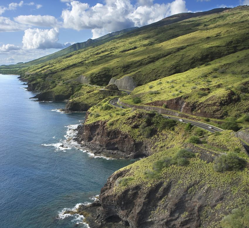
notably Ka‘a‘awa to the southeast of Hau‘ula (Figure 3) and the
Laniākea area farther northwest on the North Shore. In 2015,
Figure 2 Risk Mitigation Approach
the governor signed an Emergency Proclamation authorizing
emergency repairs of the roadway at Ka‘a‘awa. More recently,
HDOT earmarked a project to move the highway farther from In addition, the strong winds associated with hurricanes
the shoreline at Laniākea, and this stretch of highway has cause portions of buildings, telephone poles and trees/
been identified as a top-20 priority site (Francis et al. 2019). foliage to fall and block roads. In many recent storm events,
emergency crews could not reach damaged areas until the
STORM SURGE AND HIGH WINDS roads were cleared.
Storm surge resulting from tropical storms and hurricanes
INTENSIVE PRECIPITATION, LANDSLIDES, ROCK-
can exacerbate coastal erosion and cause serious damage
FALLS, DEBRIS FLOWS, AND INLAND FLOODING
to roads. Hurricane Iwa (1982), which passed just north
of Ni‘ihau and Kaua‘i as a Category 2 tropical storm, and Precipitation in the mauka and makai areas can cause
Hurricane Iniki (1992), which made landfall as a Category 4 flooding, landslides, and other geotechnical hazard events
storm on the southern shore of Kaua‘i, seriously damaged such as rockfalls and debris flows. In April 2018, heavy
many parts of the State (Robertson 2015). More recently, precipitation damaged Kūhiō Highway on Kaua‘i (Figure 4),
Hurricane Iselle (2014), which made landfall as a tropical and traffic was severely restricted for about a year while the
storm on the southeastern coast of Hawai‘i Island (Big roadway was reconstructed and stabilized. Other disruption
Island), caused power outages and much damage to examples occurred in a nearby area of Kalihiwai in northeast
communities and supporting infrastructure. Category 5 Kaua‘i. In separate occasions, in 2012 and 2018, a Kūhiō
Hurricane Lane (2018) weakened just as it approached the Highway stream crossing was re-routed because of high
Hawaiian Islands and avoided a direct hit on the State. The water flow. In February 2019, heavy precipitation caused
Hawaiian Islands will likely experience more frequent tropical multiple debris flows along the Pali Highway on O‘ahu.
storms as ocean temperatures rise and hurricane tracks shift This event caused the closure of one of the entrances to
more northerly (Yamaguchi 2019). the highway’s four tunnels, temporarily severing roadway
12 HAWAII HIGHWAYS C L I M AT E A D A P TAT I O N A C T I O N P L A N
Figure 3 Kamehameha Highway Repairs at Ka‘a‘awa, O‘ahuFigure 4 2018 Landslides on Kūhiō Highway, North Shore Kaua‘i
connectivity between the major residential communities on WILDFIRES
the Windward side of the island and the major employment Climate change is expected to result in some areas experiencing
center in Downtown Honolulu on the other side of the heavier precipitation, while others might become more prone
mountain. Traffic operations did not return to normal for to drier conditions, with each condition resulting in a greater
several months. risk of nature- and human-caused wildfires. In areas of heavier
precipitation, vegetation growth encouraged by precipitation
GROUNDWATER INUNDATION could act as fuel for future wildfires. In 2018, there were 627
The degradation of a road foundation by rising groundwater wildfires in Hawai‘i, which burned 32,386 acres of land (Pacific
seriously impacts roadway integrity that is less visible to Fire Exchange. 2019). Fire ignitions tend to occur on the drier
the traveling public than other natural hazards, requiring leeward side of islands, and they are most associated with
increased maintenance or premature replacement. Rising population centers and the presence of roads and vehicles,
groundwater also limits the capacity of the land to absorb which tend to contribute to the ignition of fires (Trauernicht 2016,
rainfall, increasing localized flooding. This groundwater Pacific Fire Exchange 2016).
inundation effect, sometimes identified first through recurrent
LAVA FLOW
high-tide flooding in low-lying areas, is already occurring.
The most notable examples on the Island of O‘ahu have Volcanic eruption and lava flows are an infrequent but
occurred in the Māpunapuna neighborhood mauka of the potentially devastating hazard in the State. Hawai‘i Island (Big
Nimitz Highway in the Honolulu International Airport area Island) is most prone to this disruption, with Kīlauea Volcano
and in the Kapi‘olani Boulevard area mauka of Ala Moana having erupted 34 times since 1952 (USGS 2020). In the most
Shopping Center. The flooding of the Mapunapuna area recent 2018 eruption, which lasted approximately 4 months
caused intrusion/backflow of seawater. At one time, this area (USGS 2019a), lava flows disrupted local roadways in the Puna
had many fishponds, which were later filled in; intruding area and cut off access to critical community assets such as
seawater has reclaimed some of the low areas. schools, local commerce, and the only boat ramp in Puna. No
State-owned roads were directly affected by the eruption,
Low-lying coastal highway areas experiencing repeated
but county roads were affected. However, State highways did
coastal erosion, such as areas along Kamehameha Highway
experience cracks in the pavement due to earthquake-related
on O‘ahu, are also susceptible to groundwater inundation or
underground movement of lava and needed repair.
a gradual transition to wetlands that may not be immediately
and readily observable (Habel et al 2020). PAST REPAIR SITES
Figure 5 shows the locations of emergency or related HDOT
TSUNAMIS
projects from 1997 to January 2019 resulting from natural hazard
Tsunamis generated by earthquakes remain a constant,
impacts. These repair projects included both emergency and
albeit infrequent, threat to Hawai‘i. Although infrequent, the
non-emergency actions needed on roads affected by weather-
consequences associated with tsunamis are significant. Two
related events (HDOT 2019b). The repair projects typically
of the most famous and deadly tsunami events occurred
resulted from severe storms, landslides, flooding, bridge/
in Hilo Bay on the Big Island in 1946 and 1960, completely
drainage, and shoreline erosion. Roughly 60 miles of the total 971
reshaping the social and economic structure of Hilo, in
miles of the State’s highway network are represented on this list
addition to changing its land use and development patterns
of repair projects during this period. Also mapped are landslides
(Pacific Tsunami Museum 2020, State of Hawai‘i 2019).
co-located with HDOT highway assets and documented in the
Tsunami wave forces have the capacity to damage bridges
USGS National Landslide Inventory (USGS 2019b).
and coastal roadways, eliminating access to communities.
HAWAII HIGHWAYS C L I M AT E A D A P TAT I O N A C T I O N P L A N 13Figure 5 Selected Repairs Sites on HDOT-Highways Roads Associated with Emergencies Since 1997
(clockwise from top left: Kaua‘i County, City and County of Honolulu, Hawai‘i County, and Maui County)
Source: State-Owned Roads: HDOT Highways Division, LRMS; Base maps: Esri, DigitalGlobe, GeoEye, Earthstar Geographics, CNES/Airbus DS, USDA, USGS, AeroGRID, IGN,
and the GIS User Community; World Ocean Reference: Esri, GEBCO, NOAA, National Geographic, Garmin, HERE, Geonames.org, and other contributors
HAZARDS EXAMINED IN Table 1 Exposure Assessments
THIS ACTION PLAN
Exposure
Hazards Examined
Understanding and proactively addressing how roads are Assessments
exposed to climate-related hazards helps inform State agencies
and communities about changing environmental conditions • Rockfalls and landslides
that may impact the performance of the highway system. The • Sea Level Rise (marine flooding and
groundwater inundation)
Exposure Assessment report describes where HDOT roads, Climate-related • Annual high wave flooding
bridges, culverts, and tunnels may be exposed to hazard events exposure
• Coastal erosion
associated with changing climate conditions. The Exposure assessments
• Storm surges
Assessment report builds on analyses undertaken to estimate • Tsunamis
future conditions by international (e.g., the Intergovernmental • Wildfires
Panel on Climate Change), national (e.g., NOAA and USGS), and
local researchers (e.g., the University of Hawai‘i, HDOT). These Other exposure
• Lava flows
assessments
overviews use the latest scientific data and analytical approaches
available for each hazard specific to Hawai‘i.
Table 1 shows the exposure assessments in this Action Plan ⊲ The results of the application of the methodology, along
and described in the Exposure Assessments document with maps and charts to communicate the degree to which
accompanying this Action Plan. assets may be affected
Each of the exposure assessment technical overviews provides ⊲ Recommendations for the HDOT
the following:
⊲ Improvements to existing data and models to support
⊲ Information on previous works and existing data the assessment of risk and resilience related to the State
road system
⊲ The methodology used for determining the exposure of
assets to the hazard of interest
14 HAWAII HIGHWAYS C L I M AT E A D A P TAT I O N A C T I O N P L A NCurrently in this stage
Exposure Vulnerability Risk Resilience
Figure 6 Assessment Steps Toward Prioritized Action
MOVING TOWARD PRIORITIZED These actions often include data gathering and field surveys
to confirm or clarify conditions assumed in this document
INVESTMENTS or to assess the vulnerability of identified assets through a
targeted stressor-damage assessment.
This Action Plan identifies the primary climate hazards that are
of a concern for HDOT assets. The Action Plan also identified an Figure 6 lays out a path for HDOT to develop a list
initial set of activities for HDOT to begin to incorporate climate of prioritized investments. The major phases can be
change concerns into the highway work program. A critical summarized as follows:
element of this Action Plan is recognizing that risk should be ⊲ EXPOSURE ASSESSMENT determines which
the driving decision factor for where and when to invest HDOT infrastructure assets could be exposed to a probable
dollars to increase the resilience of the highway system. HDOT’s hazard event or a set of probable hazard events.
Highway’s Division Mid-Range Plan (MRP) process is a good
example of an opportunity to incorporate climate adaptation data ⊲ VULNERABILITY ASSESSMENT determines how
and risk analysis into decision-making (Note that the MRP does infrastructure assets may be impacted or fail with some
not identify the projects themselves). The objectives of the MRP probability.
include the following: ⊲ RISK ASSESSMENT estimates the cost of repairs or
⊲ Better connecting the 20-year outlook of priorities and replacement associated with probable failures and can
needs established by the long-range plans, the Highways help prioritize interventions. It estimates the cost and time
Division programs, and the short-term 4-year outlook of of the broader impacts associated with probable failures
projects identified for implementation by the Statewide (e.g., societal impacts such as the consequences of lack of
Transportation Improvement Program access the availability of alternative routes, and the number
of people affected by closed roads).
⊲ Optimizing limited resources and funding in project selection
to more efficiently and effectively address needs and priorities ⊲ RESILIENCE ASSESSMENT determines the ability of
the system to meet critical functions (e.g., (un)acceptable
⊲ More effectively incorporating data-driven decision-making travel time to hospitals, etc. (un)acceptable delays in the
into project evaluation and selection delivery of critical supplies).
The MRP will evaluate projects against performance criteria The type of large-scale geographic analysis conducted for
established for each goal using a Multi- Objective Decision the Exposure phase undertaken in this Action Plan does
Analysis (MODA) process. As a tool for decision-making, not provide enough detail to lead to a capital program. The
MODA helps assess the effectiveness of projects across next phases of work for HDOT―Vulnerability and Risk―would
all Highways Division programs in meeting the Division’s need to occur to get to a point that leads to program action.
priorities, needs, and goals. It will help weigh tradeoffs More information is needed to determine the most pressing
of investment scenarios using a data-driven process and needs and the most cost-effective design and investment
help ensure projects selected for implementation address responses. HDOT will need to undertake more detailed
the highest priorities and needs and make the most site assessments to be able to understand at a finer level
effective use of limited resources. The evaluation criteria of detail whether the findings of this higher-level technical
will focus on the Highways Division goals, including safety, analysis match what is found in the field at those locations.
system preservation, modal integration, economic vitality,
system efficiency, and resiliency, and will also incorporate
considerations for project readiness, equity, and environment. PARTNERSHIPS IN
While this document is presented as an Action Plan, it is IMPLEMENTATION
important to note that the Action Plan is not accompanied by
the funding necessary to address all the concerns outlined The Action Plan recognizes that preparing and responding
in the assessments. Some actions―such as those to address effectively to the risks of climate change requires
near-term flooding from sea level rise in areas already collaboration among a wide range of public and private
experiencing rising water levels―can be implemented interests. For example, there is a mutually reinforcing
without additional analysis while others will require more interconnectedness among Federal and State laws and
detailed analysis to reach a conclusion on what risk is local ordinances that form the basis for a state-level climate
present and what adaptation action is most appropriate. adaptation policy. For HDOT to implement this Action Plan,
HAWAII HIGHWAYS C L I M AT E A D A P TAT I O N A C T I O N P L A N 15collaborative and coordinated partnerships will be necessary Some of the questions facing HDOT, just relating to sea level
for creating a resilient Hawai‘i. One way to highlight rise alone, include the following:
how changing climate conditions will require effective
⊲ Do we continue to maintain roadways near the shoreline
partnerships is to envision a Hawai‘i with sea levels that are
where damage continues to occur?
much higher than today. Certainly, many of HDOT’s roads will
be impacted, but so too will many other community assets. ⊲ Do we armor the shoreline to protect roadways, recognizing
For example, residential or commercial buildings might need that this will likely cause loss of adjacent beaches?
to be elevated or moved to higher ground, and communities
⊲ How do we create more resilient infrastructure recognizing
might need to find ways to accommodate existing and future
that such decisions could expand the footprint of
community resources within more land constraints.
the facilities and increase the impact on sensitive
It should be noted that on September 15, 2020, the environmental and cultural features?
Legislature passed HB2486 HD2 SD2, an Act that gives the
⊲ In areas where assets are most at risk:
State Office of Planning the responsibility to coordinate State
climate change efforts with attention to sea level rise. To be • Do we relocate them given existing development,
an effective partner with the Office of Planning, HDOT will natural areas, and sensitive cultural areas that have
need to have the organizational capabilities to understand the occurred based on the existence of these assets?
implications of climate change on the State’s highway system.
• Do we continue to maintain, or how long do we maintain,
The Office of Planning will clearly be an important partner in
transportation facilities in areas where communities are
implementing HDOT’s climate change strategy. In addition,
facing threats from long-term sea level rise?
HDOT collaboration with utility companies, the Transportation
Environmental Resource Council (TERC), and other State and • Are there other types of non-highway adaptation
county partners will be an important factor for success. strategies that could be considered?
The TERC – as an assembled body of county, state and ⊲ How should transportation services and highway accessibility
federal agencies in Hawaii that discuss state transportation be provided in support of development decisions that are
decisions and environmental considerations – will be a good made considering long-term climate change impacts?
avenue to work collaboratively towards implementation.
In addition, the State’s Climate Commission has a mandate to This list of example concerns is not comprehensive for
provide an overarching and interdepartmental collaboration shoreline concerns nor does it extend to the increasing risks
role among State agencies and local governments. As noted from other climate change threats outlined in this Action
in the Commission’s enabling statute, HRS 225P-3, the Plan. These questions simply highlight the many challenges
Commission “shall establish climate change mitigation and facing infrastructure agencies throughout Hawai‘i.
adaptation strategies and goals to help guide planning and HDOT’s vision is to develop and maintain a viable
implementation statewide using the latest scientific analysis and resilient ground highway system for Hawai‘i. The
and risk assessment to monitor and forecast climate change decisions relating to this vision cannot be made without
related impacts at the regional, state, and local level, including effective partnerships with many others. Figure 7 shows
any additional information deemed necessary.” As a member conceptually how partnerships among various agencies
of the Commission, HDOT will work collaboratively on efforts and organizations in Hawai‘i can work to ensure a more
to make sure its efforts and those of others are coordinated resilient future. The figure is not comprehensive nor
and targeted at meeting the goal of a more resilient prescriptive for the institutional relationships that will lead
transportation system and of more resilient communities. to success. It does suggest, however, that HDOT’s success
As Hawai‘i grows over the coming decades it seems in climate adaptation depends on such coordination and
likely that this growth will have to be accommodated in collaboration. As a steward of the State Highway network,
sustainable and resilient ways. Hundreds, if not thousands, HDOT recognizes this is the way forward and accepts
of assets are close to the shoreline that might be impacted its role. Recommendations relating to partnerships and
by rising sea levels. The public and private agreements strengthening institutional relationships are provided in the
that led to much of this development might need to be following Section 3, Implementation Plan.
revisited, and certainly new development decisions should
follow a different framework for decision-making―one that
recognizes the risks of a very different future.
16 HAWAII HIGHWAYS C L I M AT E A D A P TAT I O N A C T I O N P L A NSTATE, FEDERAL
UTILITY TERC COUNTIES PARTNER
HDOT
COMPANIES AND CITIES/ AGENCIES
TOWNS
INITIATE INDIVIDUAL CLIMATE CHANGE ASSESSMENT ACTIVITIES
Develop Climate Adaptation
Action Plan
Complete Risk Prioritization
and Capital Investment Plan
COLLABORATIVE FUNDING OF DEVELOP COOPERATIVE AGREEMENTS
MUTUALLY BENEFICIAL PROJECTS AND IMPLEMENTATION PLANS
Develop Statewide Multi-
Agency Resilience Plan and
Project Funding Program
Develop Long-Range
Resilient Hawaii Plan
Implement Transportation
Element of Long-Range
Resilient Hawaii Plan
A More Resilient Hawaii
COLLABORATING
LEAD AGENCY
AGENCY
Figure 7 Conceptual Collaboration Framework for Implementation
HAWAII HIGHWAYS C L I M AT E A D A P TAT I O N A C T I O N P L A N 17You can also read


