Climate Resilience Projects for the Triangle J Region - Chatham, Johnston, Lee and Moore Counties
←
→
Page content transcription
If your browser does not render page correctly, please read the page content below

Climate
ener

       Resilience
       Projects for
       the Triangle J
       Region
       Chatham,
       Johnston, Lee
       and Moore
       Counties
Climate Resilience Projects
  for the Triangle J Region
Chatham, Johnston, Lee and Moore Counties
             December 2022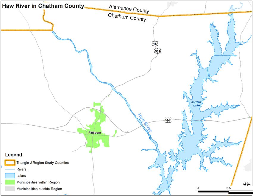
Land Acknowledgements
We wish to acknowledge and honor the Indigenous communities native to this region and
recognize that projects proposed in these pages are built on Indigenous homelands and
resources. We recognize the Lumbee, Skaruhreh/Tuscarora, Cheraw and Mánu: Yį Įsuwą
people as past, present and future caretakers of this land. We also recognize the unnamed
tribes that once oversaw these lands and have since relocated or been displaced.
About NCORR
In the wake of Hurricane Florence in 2018, the State of North Carolina established the Office of
Recovery and Resiliency (NCORR) to lead the state’s efforts in rebuilding smarter and stronger.
At that time, eastern North Carolina communities were still recovering from Hurricane Matthew,
which had impacted the State in 2016. NCORR manages nearly a billion dollars in U.S.
Department of Housing and Urban Development (HUD) funding in two grant types, Community
Development Block Grant – Disaster Recovery (CDBG-DR) and Community Development Block
Grant – Mitigation (CDBG-MIT). These are aimed at making North Carolina communities safer
and more resilient from future storms. Additional funding is provided through the State Disaster
Recovery Acts of 2017 and 2018, the Storm Recovery Act of 2019 and Economic Development
Administration Disaster Supplemental Funds. NCORR manages programs statewide that
include homeowner recovery, infrastructure, affordable housing, resilience and strategic
buyouts. NCORR is a division of the Department of Public Safety. To learn more about NCORR
programs, visit ReBuild.NC.Gov.
About RISE
Developed in partnership with North Carolina Rural Center, NCORR’s Regions Innovating for
Strong Economies and Environment (RISE) program supports resilience in North Carolina by:
Facilitating the Regional Resilience Portfolio Program, which provides coaching and
technical assistance to regional partners in the eastern half of the state to build multi-
county vulnerability assessments, identify priority actions to reduce risk and enhance
resilience in their region and develop paths to implementation.
Developing the North Carolina Resilient Communities Guide, a statewide resource
that will provide tools, guidance and opportunities for building community resilience.
Hosting the Homegrown Leaders program, a NC Rural Center leadership training
workshop, which operates in the eastern half of the state, that emphasizes resilience
as a tool for community economic development.
The RISE Regional Resilience Portfolio Program covers nine areas, which align with the North
Carolina Council of Government regions (Figure 1). This portfolio of projects is the second and
final deliverable of the Regional Resilience Portfolio Program for the Triangle J region.
Climate Resilience Projects for the Triangle J Region 3
December 2022
Figure 1. Council of Government Regions

RISE is funded by the U.S. Economic Development Administration and the U.S. Department of
Housing and Urban Development’s CDBG-MIT funds, with in-kind support from NCORR and
North Carolina Rural Center. In addition, the Duke Energy Foundation committed $600,000 in
grant funding to support the implementation of some projects identified through the Regional
Resilience Portfolio Program.

Climate Resilience Projects for the Triangle J Region                                          4
December 2022
Climate Resilience Projects for the Triangle J Region   5
December 2022

Table of Contents
1.        Introduction .................................................................................................................. 8
          1.1    Purpose of the Portfolio....................................................................................... 8
          1.2    Portfolio Development Process ........................................................................... 8
          1.3    Vulnerability Assessment Summary .................................................................... 9
                 1.3.1 Strengths Related to Resilience .............................................................11
                 1.3.2 Previous Disaster Experience.................................................................12
2.        Portfolio of Projects ....................................................................................................13
          2.1    Project 1: Develop a River Warning System.......................................................14
                 2.1.1 Project Overview ....................................................................................14
                 2.1.2 Implementation Pathway ........................................................................16
          2.2    Project 2: Plan and Prioritize Stream Restoration...............................................19
                 2.2.1 Project Overview ....................................................................................19
                 2.2.2 Implementation Pathway ........................................................................20
          2.3    Project 3: Install Backup and Redundant Power Sources...................................24
                 2.3.1 Project Overview ....................................................................................24
                 2.3.2 Implementation Pathway ........................................................................25
          2.4    Project 4: Establish a Locally Administered Repetitive Loss Program ................29
                 2.4.1 Project Overview ....................................................................................29
                 2.4.2 Implementation Pathway ........................................................................30
          2.5    Project 5: Develop a Privately Owned Dam Inventory and Dam Ownership
                 Guidebook .........................................................................................................35
                 2.5.1 Project Overview ....................................................................................35
                 2.5.2 Implementation Pathway ........................................................................38
          2.6    Project 6: Develop Regional Guidance for Coordinated Stormwater
                 Infrastructure Improvements ..............................................................................42
                 2.6.1 Project Overview ....................................................................................42
                 2.6.2 Implementation Pathway ........................................................................43
          2.7    Project 7: Develop a Heat Wave Response Protocol Template ..........................46
                 2.7.1 Project Overview ....................................................................................46
                 2.7.2 Implementation Pathway ........................................................................49
Appendix A. Portfolio Partners ..............................................................................................54
Appendix B. Proposed Projects .............................................................................................55

Climate Resilience Projects for the Triangle J Region                                                                                    6
December 2022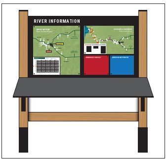
List of Figures
Figure 1. Council of Government Regions.................................................................................. 4
Figure 2. Haw River from Alamance/Chatham County Line to Jordan Lake ..............................14
Figure 3. An Example Informational Kiosk for the River Warning System..................................17
Figure 4. USACE River Mile Markers (Source: USACE Waterway Mile Markers).....................18

List of Tables
Table 1-1. List of Declared Disasters for Triangle J RISE Counties ...........................................12
Table 2-1. Triangle J Region Projects and Project Leads ..........................................................13
Table 2-2. Triangle J County-Level Precipitation Data...............................................................36
Table 2-3. Triangle J County-Level Heat Data...........................................................................47

Climate Resilience Projects for the Triangle J Region                                                                    7
December 2022
1. Introduction
North Carolina’s residents, businesses, nonprofit organizations and governmental organizations
are increasingly concerned by the growing frequency and intensity of heat waves, storms,
changing precipitation patterns and their impacts. To encourage regional coordination on
identifying vulnerabilities and solutions to these challenges, the North Carolina Office of
Recovery and Resiliency (NCORR) with staff support from North Carolina Rural Center (NC
Rural Center) created the Regions Innovating for Strong Economies and Environment (RISE)
program. One RISE program component is the Regional Resilience Portfolio Program, which
consists of two steps: a vulnerability assessment and a portfolio of projects. Each of the nine
regions participating in RISE has developed a vulnerability assessment and a portfolio of
projects to reduce risk and increase resilience in those regions.
This document presents the portfolio of projects for Chatham, Johnston, Lee and Moore
Counties in the Triangle J Council of Governments region, referred to herein as the “Triangle J
region.” The project team opted to not include Durham, Wake and Orange counties because
they were included in the 2019 Triangle Regional Resilience Assessment. 1

1.1 Purpose of the Portfolio
The aim of the portfolio of projects, the final deliverable in the two-step RISE program, is to
identify high-impact priority actions that reduce risk and enhance resilience across the region.
Each project includes a pathway to implementation. Local leaders selected actions that address
the vulnerabilities identified in the Triangle J region’s Vulnerability Assessment, developed as
the first deliverable of the RISE program and selected actions that can be implemented in the
near to medium term. The goal is to produce shovel-ready actions with detailed implementation
steps, including estimated costs, where to find funding opportunities, staff resources needed to
complete the project, additional resources needed, likely project completion challenges and
more.

1.2 Portfolio Development Process
The project team, which includes staff from NCORR, the Triangle J Council of Governments,
AECOM and a local facilitator, worked with the Stakeholder Partnership and the public to
develop the projects included in the Triangle J portfolio. The Stakeholder Partnership included
local leaders across the public, private and nonprofit sectors and representation from the four
Triangle J RISE counties. See Appendix A Table A-1 for the list of active participants. The
Stakeholder Partnership met nearly every month between January 2022 and December 2022.
Members of the Stakeholder Partnership and participants in public workshops voiced support for
all actions in the portfolio.

1Triangle J Council of Governments, Triangle Regional Resilience Assessment. 2019.
https://www.tjcog.org/publications/triangle-regional-resilience-assessment.

Climate Resilience Projects for the Triangle J Region                                             8
December 2022
The Triangle J region’s vulnerability assessment 2, summarized in Section 1.3, served as a basis
for brainstorming and action-building. Initially, the project team asked the Stakeholder
Partnership members for project ideas at the county level. Participants in county-specific
breakout groups suggested projects and referenced existing hazard mitigation plans for
Chatham, Johnston, Lee and Moore Counties. Common themes and goals emerged from
shared concerns across the counties, which helped to determine appropriate actions for region-
wide resilience.
The project team and the Stakeholder Partnership initially identified a list of 26 projects (see
Table B-1 in Appendix B) that they narrowed and refined to seven projects with input from the
public and a prioritization tool. During Stakeholder Partnership meetings, attendees discussed
potential solutions for vulnerabilities described in the Vulnerability Assessment, locations and
contextual details. The Stakeholder Partnership narrowed the list to 10 projects at the June
2022 meeting. The project team prioritized the 10 remaining projects using a tool developed by
AECOM. The prioritization tool compared projects based on their ability to address social
vulnerabilities and climate vulnerabilities identified in the Vulnerability Assessment, the
availability of relevant funding options and the potential return on investment. The project team
further refined the project list by merging similar actions, cutting projects that lacked sufficient
information and evaluating viability. In September 2022, the project team presented eight
projects for input at two public meetings. Subsequent discussion led the team to combine two of
the projects into one. The project team to settled on the final seven projects included in this
document.
Once the project team finalized the list of projects, they held meetings and conducted research
to identify project leads and refine each implementation pathway. The project leads are listed in
Table 2-1 in Section 2, as well as within each project’s Implementation Pathway section.

1.3 Vulnerability Assessment Summary
The following summary is based on the Vulnerability Assessment for the Triangle J region. For a
full description of the region’s vulnerabilities, refer to Climate Change and Natural Hazards
Vulnerability Assessment for the Triangle J Region.
The Triangle J region, like much of eastern and central North Carolina, is vulnerable to climate
change and natural hazards. Past experiences with disasters and climate stressors demonstrate
the vulnerabilities the region faces. However, climate change is also shifting the profile of risk
and vulnerability in the region, and it is critical to understand how the future may look different
from the past. Anticipating these impacts helps to build a region’s resilience.
Assessing vulnerabilities at the regional scale has several advantages. Natural hazards,
including rapid-onset hazards like hurricanes and slow-onset hazards like drought, often have
an impact larger than one county but smaller than the state. In other words, they have regional
impact. Regional-scale resilience strategies can build economies of scale in responding to

2NCORR, Climate Change and Natural Hazards Vulnerability Assessment for the Triangle J Region,
2022

Climate Resilience Projects for the Triangle J Region                                               9
December 2022
shared vulnerabilities. Collaboration and partnerships among smaller communities can
contribute to outcomes that would not be possible if undertaken individually.
The Triangle J RISE Region Vulnerability Assessment supports priority problem identification,
establishing a common understanding of multi-county hazards, hazard-prone areas, associated
impacts and affected populations. With this information, stakeholders can craft solutions that
respond to the highest priority needs and address lesser-known concerns that emerge in the
analysis.
The Triangle J region is vulnerable to the following climate change and natural hazards:
Hurricanes and storms and flooding
Heavy precipitation and wind damage
Extreme temperatures, including high heat indexes and wet bulb globe temperature
Drought and wildfires
There are a few primary issues, described below, that drive vulnerability in the region.
Flood vulnerability. The Triangle J region is highly vulnerable to flooding from
hurricanes and other storms. Hurricane Matthew (2016) flooded hundreds of homes
and businesses in the region, closed roads and led to other infrastructure failures.
Furthermore, the context for flooding is changing rapidly as climate change increases
the likelihood of more intense storms with heavier rainfall amounts inside and outside
the region. These occurrences directly impact homes, businesses, people and
infrastructure.
Flood vulnerability and land use change. One of the challenges to reducing flood
risk is that new development and growth are accelerating in and around the Triangle
J region. Growth contributes to a community’s economic prosperity, associated land
use changes and increases in impervious surfaces, all of which drive increased flood
risk for new and old residents alike. An increase in impervious surfaces has adverse
impacts on natural systems like forested ecosystems and wetlands, which act as
sponges to absorb precipitation and runoff. More impervious surface area leads to
less infiltration and more stormwater runoff. This reduction in natural water
absorption is straining stormwater systems and increasing flood impacts. Any new
development placed in or near the floodplain also creates new vulnerabilities.
However, it is evident that the region needs additional housing development, as
regional growth has strained the existing housing stock and there is a shortage of
housing to meet growing population.
Housing conditions and disparities. In the Triangle J region, pockets of high social
vulnerability and concentrations of inadequate housing and housing characteristics
put people at risk. Flooding is the greatest threat to a building in North Carolina, but
wind and extreme heat also present problems for the region’s housing stock. Moore,
Lee, Chatham and Johnston Counties have high concentrations of mobile homes,
which typically are less able to withstand severe weather of all kinds. The lowest
income residents have some of the greatest vulnerabilities, facing cost burden from
housing and energy consumption.
Climate Resilience Projects for the Triangle J Region 10
December 2022 Infrastructure at risk. The Triangle J region’s infrastructure is at risk, especially
from flooding. There are many roadways that overtop during typical rain events, in
addition to hurricanes and other extreme storms. Hurricane Matthew exposed
weaknesses in stormwater systems, many of which were built with older design
standards set when engineers needed to account for fewer users and lower
precipitation levels. Hurricane Matthew also demonstrated catastrophic impacts
typical of larger storms in the region, such as overtopping wastewater systems and
closing interstates.
Health concerns. Public health impacts are a major concern, as well, in the Triangle
J region. Cardiovascular and respiratory systems are taxed by high heat and
humidity, as well as poor indoor air quality after floods. While high heat is the number
one weather-related cause of death in the country according to NOAA and the
Centers for Disease Control and Prevention (CDC), major storms in the region have
also led to injuries and deaths. Experiencing a major disaster is often traumatic, and
mental health burdens are among the least reported health problems associated with
disaster. Collective levels of trauma lead to adverse impacts inside and outside the
home.
1.3.1 Strengths Related to Resilience
Because North Carolina has suffered multiple large-scale flooding and coastal storm disasters
in recent years, there has been an urgent focus on planning for recovery and resilience. The
Triangle J region has increased awareness of flood risk and the need to prioritize mitigation
measures.
1.3.1.1 Strong Planning Capacity and Previous Planning Efforts
At the county scale, the Triangle J region has a breadth of plans, ordinances and capabilities
that reflect capacity to build resilience and commitment to strategic action. All Triangle J
counties are included in the current Cape Fear Regional Hazard Mitigation Plan. All four
counties also have Hurricane Matthew Resilient Redevelopment Plans, discussed in the next
section. Notably, all four counties have comprehensive plans, open space management plans
and zoning ordinances. These plans and ordinances can be helpful for directing development in
safe areas and aligning hazard resilience with local vision. Within these plans are programs,
policies and ordinances that help protect environmental, historic and cultural resources within
each community. These tools present significant opportunities to integrate resilience principles
and practices into the local decision-making processes to increase resilience at the regional
scale. Specific to flood hazards, all counties have floodplain ordinances and flood damage
prevention ordinances and all participate in the National Flood Insurance Program. Only Lee
County does not have a Stormwater Management Plan or Ordinance.
1.3.1.2 Hurricane Matthew Resilient Redevelopment Plans
In December 2016, the North Carolina General Assembly established the North Carolina
Resilient Redevelopment Planning program as part of the 2016 Disaster Recovery Act in
response to Hurricane Matthew. All 50 of the affected counties, including Chatham, Johnston,
Lee and Moore, developed a Hurricane Matthew Resilient Redevelopment Plan. The purpose of
Climate Resilience Projects for the Triangle J Region 11
December 2022these plans was to empower communities to prepare locally driven, resilient redevelopment plans. These plans aimed to identify redevelopment strategies, innovative construction projects and other actions that allow each county to adequately respond to natural hazards as they continue to increase in frequency and intensity. This planning effort highlights the region’s capacity to proactively respond to devastation to reduce future impacts. The development and partial implementation of the resilient redevelopment plans involved collaboration between state, county and local agencies displaying the region’s ability to leverage efforts to achieve the most beneficial outcome. Based on work that each county in the region has completed from the Hurricane Matthew Resilient Redevelopment Plans, intact emergency management plans and operations centers, the region has a good foundation from which to further address vulnerabilities. 1.3.2 Previous Disaster Experience The Cape Fear Regional Hazard Mitigation Plan lists the past federally declared disasters for the Triangle J RISE counties (Table 1-1). Table 1-1. List of Declared Disasters for Triangle J RISE Counties Year Description Chatham Johnston Lee Moore 1968 Severe Ice Storm X X X 1996 Blizzard of ’96 X X X X 1996 Hurricane Fran X X X X 1999 Hurricane Floyd X X X X 2000 Severe Winter Storm X X X X 2002 Severe Ice Storm X X X X 2003 Hurricane Isabel X 2011 Severe Storms, Tornadoes and Flooding X X 2011 Hurricane Irene X 2016 Hurricane Matthew X X X X 2018 Hurricane Florence X X X X 2019 Tropical Storm Michael X Source: North Carolina Emergency Management, Cape Fear Regional Hazard Mitigation Plan Final. 2020 https://gis.aecomonline.net/irisk2/Documents/Cape%20Fear%20Regional%20Plan/Support/Cape_Fear_ Regional_HMP_Final.pdf The Cape Fear Regional Hazard Mitigation Plan shows the Triangle J region RISE counties as experiencing 19 years of drought occurrences (including abnormally dry) from 2000 to 2019 with Chatham, Lee and Moore counties having three years of exceptional drought occurrences and Johnston County having two years of exceptional drought occurrences. The plan also stated that there were no reported extreme heat or heat wave events in these counties. However, all four counties were ranked as a medium probability of future occurrences meaning there is between a 1% and 10% annual probability of a drought or extreme heat event happening in the future. Climate Resilience Projects for the Triangle J Region 12 December 2022
2. Portfolio of Projects
This chapter provides details on the portfolio of projects for the Triangle J region. The
descriptions include vulnerabilities that would be addressed by the project, potential project
locations, project leadership commitments, steps for implementation, possible funding sources
and potential barriers. Table 2-1 lists the projects covered in the following sections, as well as
the lead implementers. The project team identified lead implementers based on their area of
expertise, familiarity with the project and interest and capacity to guide the project to completion.

Table 2-1. Triangle J Region Projects and Project Leads

 Project                                                Name                Title, Organization

 Project 1: Develop a River                      Emily Sutton      Haw Riverkeeper, Haw River Assembly
 Warning System
 Project 2: Plan and Prioritize                  Rick Savage        Executive Director, Carolina Wetlands
 Stream Restoration                                                              Association

 Project 3: Install Backup and                   Matthew Britt        Director, Lee County Emergency
 Redundant Power Sources                                                         Management
 Project 4: Establish a Locally                  Emily Barrett      Environment and Resilience Program
 Administered Repetitive Loss                                    Manager, Triangle J Council of Governments
 Program
 Project 5: Develop a Privately               Deborah McGuffin       Director, Moore County Cooperative
 Owned Dam Inventory and Dam                                                      Extension
 Ownership Guidebook

 Project 6: Develop Regional                 Stephen Wensman        Planning Director, Town of Smithfield
 Guidance for Coordinated
 Stormwater Infrastructure
 Improvements

 Project 7: Develop a Heat Wave                  Anne Lowery       Environmental Health Director, Chatham
 Response Protocol Template                                                       County

Suggesting new projects often surfaces concerns about funding and capacity. The
implementation pathways below describe feasible funding options. In addition to the project
leads, finding ways to place staff at the Triangle J Council of Governments to focus on
implementing RISE projects may be a useful strategy. Such staff could minimize the challenge
of coordination across jurisdictions and support grant writing and regional communication.
Furthermore, as the RISE program lead, NCORR intends to stay involved in the implementation
of each project, as permitted by capacity and funding.

Climate Resilience Projects for the Triangle J Region                                                       13
December 2022
2.1 Project 1: Develop a River Warning System
2.1.1          Project Overview
2.1.1.1        Project Description
The Stakeholder Partnership identified the need for a river warning system to address hazards
caused by hurricanes, storms and heavy precipitation. The river warning system would include a
mile-marker system, a notification system and educational programming. The mile-marker
system would be created in coordination with emergency responders to improve locational
awareness for both river users and emergency management response teams to ensure that, if a
river rescue is needed, responders can accurately locate individuals relevant to river access
points.
The notification system would display the river level, river heath and potential riverine dangers
at defined times. The information provided by the notification system would enable safe use of
the river by all river users, including but not limited to recreational users. The notification system
would be a coordinated process for the watershed’s community to be alerted of flooding
problem locations along the river network.
As the third and final
component of the
project, an educational
program would be
created to inform
residents and river
users of the mile-
markers and
notification systems.
Data on river conditions
could be gathered
through North Carolina
Emergency
Management’s Flood
Inundation Mapping
Alert Network (FIMAN)
and distributed to river
users via a digital
platform and through
message boards
located at river put ins            Figure 2. Haw River from Alamance/Chatham County Line to
and other access                    Jordan Lake
points.
The Stakeholder Partnership identified the Haw River from the Chatham - Alamance boundary
to Jordan Lake as a potential pilot project location (see Figure 2).

Climate Resilience Projects for the Triangle J Region                                               14
December 2022
2.1.1.2        Vulnerabilities Addressed
The river warning system would alert river users and individuals near the river of potentially
dangerous high-water levels. Several of the counties in the region noted that river users are
often unaware of where structures could cause harm along the river, especially when rivers are
at elevated levels. Further, river users are often unaware that river conditions can vary along
different segments due to dam releases and localized heavy rains. Education would encourage
the proper use of the river, allowing for better use of the natural resource and the ability to take
care of oneself and those around them in the case of a river hazard.
2.1.1.3        Potential Impact
A river warning system could save lives and reduce injury, as well as reduce costs associated
with river rescues. Costs associated with rescues are high and typically passed on to the
taxpayers. While costs vary, past rescues have been estimated to cost taxpayers thousands of
dollars with some rescues costing upwards of $20,000. During the period from 2012 to 2016, 11
swift water rescues occurred on the Haw River. 3
The opportunity for collaboration and partnerships is a valuable co-benefit. Rivers in the region
cross multiple county and cities lines, and several political boundaries are defined by rivers. As
such, a river warning system requires multi-jurisdictional coordination, which would help
strengthen partnerships in emergency management and other governmental agencies at every
level.
2.1.1.4        Relevant Context
Currently, Haw River water levels are available through the National Weather Service, the U.S.
Geological Survey and links such as the Friends of Lower Haw River State Natural Area
website. The Friends of Lower Haw River State Natural Area is a chapter of the non-profit North
Carolina Friends of State Parks, Inc. Recreational users can see graphs for recent, forecast and
99-day historic river levels for the Haw River at three locations, including two in the Triangle J
region in Chatham County. However, most recreational river users are unaware of these
resources or do not make use of them in advance of a river activity.
Members of the Carolina Canoe Club have an informal notification system that uses social
media and SMS messaging to notify other users when and where they find manmade or natural
obstruction such as a tree, root system, fencing, guard rails or other river hazards.
2.1.1.5        Locations and Beneficiaries
Implementation of the proposed river warning system at the pilot location would directly benefit
Haw River’s recreational users and emergency responders in Chatham County. If successful in
the Haw River, the project could be applied to other river systems in the Triangle J region, such
as the Deep River and the Neuse River. The project could also serve as a template for other
river systems throughout the state.

3WRAL, “Taxpayers foot big bill for dangerous Haw River rescues.” 2016.
https://www.wral.com/taxpayers-foot-big-bill-for-dangerous-haw-river-rescues/15904836/.

Climate Resilience Projects for the Triangle J Region                                              15
December 2022
2.1.2 Implementation Pathway
The lead implementer recommended for this project is Emily Sutton, Haw River Assembly Haw
Riverkeeper. Ms. Sutton indicated that she has the capacity to organize the planning efforts for
the project, but would need assistance in identifying project partners and, potentially, technical
assistance if engineering or other specialized input is required. Gretchen Smith with the Friends
of the Lower Haw River State Natural Area can also help with the implementation of the project.
The lead implementer will serve as the project manager, coordinate partnerships and find
funding for project completion. Potential project partners include:
County and municipal emergency managers,
County and municipal parks and recreation departments,
Recreational groups such as the Carolina Canoe Club and
Non-profit river supporters such as the Friends of Lower Haw River State Natural
Area.
2.1.2.1 Implementation Steps
The lead implementer would undertake the following steps to complete the project:
1. Establish a steering committee to guide the development of the three facets of the river
warning system: the mile marker system, the warning system and the educational outreach.
2. Coordinate meetings between the steering committee and all emergency responders that
could respond to calls along the extent of the Haw River to discuss an effective mile marking
system for the river basin. Specific tasks include the following:
a. Determine the methods for marking the river so that it can be seen by users and
emergency responders.
b. Determine whether there are current marking systems that could be used or
incorporated into the warning system.
c. Determine who will be responsible for the maintenance of the markers and what type of
maintenance may be needed based on the type of markers used.
d. Identify structure owners (i.e., North Carolina Department of Transportation bridges) that
will need to be coordinated with and how the coordination will take place. Identify other
coordination partners, such as river users and nonprofit organizations who can help
inform river users and the public about the river warning system.
e. Determine how the mile maker system will be incorporated into the warning system.
3. Coordinate meetings between the steering committee and recreational groups, park
managers and non-profit organizations with vested interest in developing a river warning
system that would alert users of current river conditions. At this meeting:
a. Identify a preferred warning system type, such as static or electronic kiosks at put ins
and other access points, an app that river users could download to mobile devices or a
combination of all three. Signage guidelines developed in the American Whitewater
Climate Resilience Projects for the Triangle J Region 16
December 2022Open-Source Signage Toolbox 4 could be used as a basis for kiosks and other signage
related to the warning system (Figure 3).
b. Determine the frequency of updates or alerts and
who will be responsible for updating the
notification system.
c. Identify the parties responsible for
implementation and maintenance.
4. Once the mile marker and river notification systems
have been implemented, develop and implement an
outreach approach to educate river users on how to
use the two systems. In identifying the outreach
methods, consider the following questions:
a. Who needs to know about these projects?
b. How will people use the system?
c. How will people update information to the Figure 3. An Example
system? Informational Kiosk for the River
d. Who will train end users and organization staff? Warning System
5. Meet annually to solicit input from emergency Source: American Whitewater Open-
managers on the successes or failures of the mile Source Signage Toolbox, 2022
marker system and the river warning system with the
goal of making improvements to ensure that the system is effective.
2.1.2.2 Resources for Implementation
Costs and Funding
The cost of developing a river warning system is determined by the cost of a consultant to assist
the steering committee. Consultant costs could range from $25,000 to $150,000 depending on
the extent of the consultant involvement and the extent of the river covered. Costs to implement
the river warning system will be developed during the planning process and would include costs
for infrastructure (i.e., signposts for the mile marking system).
The following funding options may align with this project. Note that eligibility, project preferences
and allocation amount of all grant opportunities, especially those managed by the state and
federal governments, can change from year to year.
Emergency Management Performance Grant (EMPG). This NC Department of Public
Safety fund is available annually to county governments and is used to support
emergency management activities while addressing issues of national concern. 2022
EMPG national priorities included equity, climate resilience and readiness. The 2022
application was due in April. Funding is dependent upon the federal availability of
funds from year to year. This funding source could be used for the development and
implementation of the mile marker system and river warning system.
4American Whitewater, Open-Source Signage Toolbox. 2022.
https://www.americanwhitewater.org/content/Safety/signage
Climate Resilience Projects for the Triangle J Region 17
December 2022 Duke Energy Accelerator Grant. The Duke Energy Foundation will grant approximately
$65,000 for a RISE portfolio project. This funding, administered in partnership with
NCORR can be used to secure funds from other sources. The application deadline will
be the first quarter of 2023. This funding source could be used for the development
and implementation of all three parts of the program.
Personnel Capacity and Expertise
The development of the mile marker system and river warning system would likely require
technical expertise that may not be available locally. The steering committee would likely need
to retain a firm with river wayfinding experience and emergency management experience.
Information, Mapping and Data
Accurate mapping of the Haw River would be needed to establish the mile marker system.
2.1.2.3 Challenges and Barriers to Implementation
One of the challenges to developing the river warning system is that it could be the first of its
kind in North Carolina and possibly the country. While the warning system may utilize existing
infrastructure (i.e., FIMAN gauges) used for
warning the public of rising waters, the idea of
passing that information to recreational users is
new. Therefore, there is no template for
developing the warning system. Coordination of
multiple emergency management districts
would also challenge the development of the
mile marker system.
2.1.2.4 Maintenance and Operations
Maintenance related to the mile marker system
will include inspection, repair and possibly
replacement of sign poles and other
infrastructure. Similarly, the river warning
system would need regular maintenance and
repair if kiosks are chosen to distribute the
information. The parties who are responsible for
ongoing maintenance of both the river warning
system and the mile marker system should be Figure 4. USACE River Mile Markers
vetted in implementation steps 1 and 2. (Source: USACE Waterway Mile Markers)
2.1.2.5 Opportunities for Integration
The United States Army Corp of Engineers has mile marker systems of inland waterways and
the Gulf Intracoastal Waterway (Figure 4). These mile marker systems along major river
networks were created for navigation purposes. The markers appear in a geospatial digital form
but do not appear to be used for emergency response.
Climate Resilience Projects for the Triangle J Region 18
December 20222.2 Project 2: Plan and Prioritize Stream Restoration 2.2.1 Project Overview 2.2.1.1 Project Description The Stakeholder Partnership identified the need to plan, prioritize and implement stream restoration projects. The project would mitigate flood issues that impact developed areas along an entire stream or river network in Johnston and Chatham Counties. Examples of problems to be addressed include natural or manmade erosion, debris buildup and other climate-driven issues such as regular flooding in developed areas. The project would identify local sources of impairment, develop a process for identifying and prioritizing stream restoration solutions and demonstrate regional benefits by taking downstream and upstream actions into consideration. The intention would be to avoid damage to natural habitats and manmade structures while holistically considering the stream network, from headwater to output. The locations along stream networks that are most vulnerable would be prioritized in coordination with state and local officials as well as stream restoration experts. 2.2.1.2 Vulnerabilities Addressed This project has the potential to address several vulnerabilities. Members of the Stakeholder Partnership from Johnston and Chatham Counties identified stream erosion and debris buildup as issues caused by land use changes associated with continued development. Some stream impairments can lead to flooding during heavy rain events as well as increased damage to already impacted locations along the river. Restoring streams can reverse ecological damage to a stream network and maintain or improve natural habitats. Stream restoration can also provide safe locations for recreation such as swimming, canoeing and fishing. In addition, land use changes directly impact stream networks. Planners and developers consider impacts in the immediate area of the change, but often miss the upstream and downstream impacts. The addition of impervious surface decreases the amount of water that can be handled on-site, sending more water to the stream, which causes erosion, sedimentation and debris buildup. This project would attempt to manage flooding in one stream that crosses multiple jurisdictions, identifying solutions for locations that have been impacted by erosion or degradation from upstream and downstream land use changes. Ideally, the project would alleviate flooding impacts on housing, infrastructure and public health. 2.2.1.3 Potential Impact Stream restoration would have both regional and local benefits. On a regional scale, stream restoration has the potential to prevent damage from floods, improve aquatic habitat, improve habitat along the banks of the waterway and compensate for impacts that result from roadway projects or other development. Locally, restoring streams could prevent flooding of residences and businesses as well as improve water quality, reduce erosion, provide recreational opportunities for residents and increase ecosystem resilience. This project could prevent flooding that occurs because of stream impairment and stream degradation, as well as improve downstream water quality. Stream restoration projects can Climate Resilience Projects for the Triangle J Region 19 December 2022
benefit communities that are prone to flooding and that have experienced pollution from
upstream actions.
2.2.1.4 Relevant Context
All four of the Resilient Redevelopment Plans 5 for the Triangle J region discuss stream
restoration and identify locations in need of flood prevention. Additionally, the North Carolina
Department of Natural and Cultural Resources has conducted stream restoration projects
throughout the state, including in the Triangle J region, with financing from the North Carolina
Land and Water Fund. All 2021 projects in the Triangle J region, including five projects in Moore
County, three in Chatham and one in Lee, were land acquisitions. More information on these
projects can be found at https://nclwf.nc.gov/funded-projects.
2.2.1.5 Locations and Beneficiaries
The Stakeholder Partnership identified several locations in need of stream restoration:
Chatham County identified restoration needs for a tributary of the Rocky River
northeast of Siler City.
Chatham County also identified Pokeberry Creek near where it enters the Haw River,
an unnamed tributary of the Haw River adjacent to the US 64 Haw River Canoe
Access and the canoe input/takeout on the Haw River above the Bynum Dam.
Johnston County identified the Neuse River, Middle Creek, Swift Creek, Little River
and its tributaries.
The Lee County Resilient Redevelopment Plan identified Little Buffalo Creek near
Sanford.
The Moore County Resilient Redevelopment Plan identified the need for stream
restoration along the eastern section of Little River from Crystal Lake Dam to Spring
Lake Streams, Crane Creek around McGill Road and north to US 1, Bear Creek and
Deep River.
2.2.2 Implementation Pathway
The lead implementer for this project is Rick Savage, Carolina Wetlands Association Executive
Director. Mr. Savage has indicated that he has the capacity to take on the project.
The lead implementer will serve as the project manager, coordinate partnerships and work to
find funding for project completion. Potential partners include:
NC Department of Natural and Cultural Resources,
NC Department of Transportation,
NC Floodplain Mapping Program,
Stream restoration experts,
Local governments impacted by the stream,
Floodplain managers and
Local government planners.
5 https://www.rebuild.nc.gov/resiliency/hurricane-matthew-resilient-redevelopment-plans
Climate Resilience Projects for the Triangle J Region 20
December 20222.2.2.1 Implementation Steps
The lead implementer would undertake the following steps to complete the project:
1. Establish a steering committee of partners who can identify stream restoration solutions and
methods, identify funding and work with contractors to do the stream restoration work.
2. Develop a list of stream restoration needs throughout the region, considering problem areas
that have been identified through the RISE program, in other documents and those that may
be identified by the steering committee.
3. Prioritize the list of stream restoration projects based on a methodology developed by the
steering committee. This methodology could include the level of impairment (i.e., pollution
levels in the stream), length of impairment, number of residents affected by the impairment,
high-level costs for restoration and benefits or impacts of restoration.
4. Identify one to three pilot projects from the prioritized list that could serve as templates for
future projects in the region. Project selection could be based on the effort required or the
geographic size of the restoration project. It could also be based on the total population
affected by the restoration, such as the number of residents within one mile of the stream.
5. Have restoration experts review the pilot locations to create a site-specific plan for the
stream restoration, including identifying the source and cause of impairment, potential
method or methods of restoration, costs associated with the restoration and impacts of the
restoration actions. This information would support grant applications for each site.
6. Document the best practices used in each pilot to help replicate projects in other streams
where issues and concerns are similar.
2.2.2.2 Resources for Implementation
Costs and Funding
Generally, estimating costs for stream restoration is based on the total linear foot of the
proposed improvements. Estimating costs for stream restoration is difficult because many
variables affect the cost, including whether the stream is in an urban or rural environment, the
length of the restoration and how accessible the stream is for constructing stream restoration
improvements. The inclusion of stream restoration experts on the steering committee could
provide clarity related to costs early in the process.
The following funding options may align with this project. Note that eligibility, project preferences
and allocation amount of all grant opportunities, especially those managed by the state and
federal governments, can change from year to year.
Water Resources Development Grant (WRDG). The program, managed by the North
Carolina Division of Water Resources, provides funding to local jurisdictions to
complete projects for stream restoration, water management, water-based
recreation, and preliminary feasibility or engineering studies for any of these eligible
uses. Water management includes stormwater control measures, drainage, flood
control and hydrologic restoration. This program includes the Coastal Storm Damage
Mitigation Fund. It also funds drainage by removal of debris.
Climate Resilience Projects for the Triangle J Region 21
December 2022 Five Star and Urban Waters Restoration Grant Program. This program, managed by
the National Fish and Wildlife Federation, funds projects that “include a variety of
ecological improvements along with targeted community outreach, education, and
stewardship. Ecological improvements may include wetland, riparian, forest, and
coastal habitat restoration; wildlife conservation, community tree canopy
enhancement, habitat, water quality and green infrastructure best management
practices for managing run-off.” This grant could be used to fund implementation.
Watershed and Flood Prevention Operations (WFHO). The WFPO program,
administered by the USDA, provides technical and financial assistance to States,
local governments and Tribal organizations to help plan and implement authorized
watershed projects. Funding can be used for the purpose of flood prevention,
watershed protection, public recreation, agricultural water management, water quality
management and more.
North Carolina Land and Water Fund (NCLWF). Coordinated through the NC
Department of Natural and Cultural Resources, the NCLWF is given to (1) enhance
or restore degraded waters; (2) protect unpolluted waters; (3) contribute toward a
network of riparian buffers and greenways for environmental, education and
recreational benefits; (4) provide buffers around military bases to protect the military
mission; (5) acquire land that represents the ecological diversity of North Carolina;
and (6) acquire land that contributes to the development of a balanced state program
of historical properties. NCLWF also funds innovative stormwater solutions and
planning grants. NCLWF can consider funding innovative stormwater projects that
demonstrate a novel and untried method to water quality at the project site and how
it would contribute to achieving NCLWF’s goal of advancing stormwater-
management practices for water quality. Recently, most planning applications have
taken the form of watershed or river corridor plans to identify and prioritize
restoration opportunities. This grant could be used as a funding source for identifying
stream restoration activities, step 5 described above.
NC DEQ’s 319(h) Grant Program provides funding to reduce nonpoint source
pollution. The funding is provided through the U.S. Environmental Protection Agency
and North Carolina typically receives $1 million annually for competitive funding.
Funds may be used to conduct watershed restoration projects such as stormwater
and agricultural best management practices and restoration of stream channels.
Section 319 grant projects must be used to help restore waterbodies that are (1)
currently impaired by nonpoint source pollution and (2) in areas with DWR-approved
approved watershed restoration plans. Climate resilience is a review criterion, as of
FY 2022. State and local governments, interstate agencies, public and private
nonprofit organizations including academic institutions, and state-recognized tribes
are eligible to apply. This grant could be used as a funding source if the grant
application includes water quality and flood management as two project goals.
Section 205(j) Water Quality Management Planning Grant. Through the Section
205(j) Grant program, the U.S. Environmental Protection Agency provides states with
funding for water quality planning. North Carolina typically receives around $150,000
for competitive funding of water quality planning projects. These projects can involve
Climate Resilience Projects for the Triangle J Region 22
December 2022identifying the nature, extent and cause of water quality problems or planning work to
address those problems. 205(j) grants are eligible to regional Councils of
Government; COGs may partner with any public sector organization to implement
projects. A match is preferred, but not required. This grant could be used as a
funding source if the grant application includes water quality and flood management
as two project goals.
Personnel Capacity and Expertise
Stream restoration is a specific skill set focused on restoration benefits and engineering. The
project would likely require hiring specialists that have a knowledgeable background in
restoration needs and impact of restoration practices. This need can add a significant cost to the
work that needs to be done to ensure the correct measures are followed for the benefit of the
community.
Information, Mapping and Data
Accurate stream Geographic Information System (GIS) data as well as updated National
Pollutant Discharge Elimination System GIS data would be useful in identifying the location of
potential stream restoration locations.
2.2.2.3 Challenges and Barriers to Implementation
Debris removal and erosion repair can have positive stream restoration impacts; however,
sometimes the best practice is to leave the damage and debris alone. Decisions on how a
stream should be managed are often controversial and can cause contention among the
participating parties. Mechanisms must be in place to manage the differing opinions associated
with these tasks.
2.2.2.4 Maintenance and Operations
Following project completion, continuing land changes and manmade infrastructure will create
additional stream restoration needs. Opportunities exists to work with floodplain managers and
the NC Land and Water Fund to determine in advance how local land changes may impact
waterways upstream and downstream, thereby resolving issues before they become a problem.
2.2.2.5 Opportunities for Integration
Several stream restoration projects are ongoing. Regular meetings should be scheduled with
the NC Land and Water Fund to see how work progresses in the future so that local
governments can plan for stream needs in their jurisdiction.
Climate Resilience Projects for the Triangle J Region 23
December 20222.3 Project 3: Install Backup and Redundant Power Sources 2.3.1 Project Overview 2.3.1.1 Project Description Staff at Lee and Moore County governments, with support from other counties in the region, identified the need for backup and redundant power sources at 22 critical locations. The project would identify the correct alternative power solutions for each location and provide the equipment and connections to ensure sufficient power to maintain operations during and post- disaster. Backup power sources include but are not limited to generators, voltage converters and automatic transfer switches that enable continuous delivery of electrical power during disasters. Redundant power sources may include other power sources such as microgrids, which can be disconnected from the traditional energy grid and operate autonomously. 6 2.3.1.2 Vulnerabilities Addressed By preventing power outages at critical facilities, this project would reduce lost school and public service operations, as well as loss of life caused by inoperable critical facilities and equipment. Power outages are often caused by hurricanes, flooding and extreme temperatures, the three climate change and natural hazard risks that pose the most risk to the Triangle J region. 2.3.1.3 Potential Impact This project would prevent power disruptions at multiple facilities. Given the locations identified for backup and redundant power sources, this action would increase response capacity and speed, keep the community connected with loved ones, avoid potential health impacts and reduce illness and loss of life. Some locations may serve as cooling stations where vulnerable populations can gather to get out of the heat. Other locations will allow emergency response centers to continue operations during electrical outages. Many times, an individual county does not act alone in emergency event response; adjacent counties often provide service to support evacuation and sheltering needs. Shelter locations with a reliable power source provide the resilience the region needs. The backup power sources provided by this project would serve residents of the municipalities and counties where the power sources are placed. Since the backup power sources would be placed in shelters that serve individuals who are sheltering from outside of the region, they would provide a regional benefit to residents from all over the state. The additional power sources would also benefit low-income populations, particularly related to cooling centers since low-income populations generally have limited access to air conditioning or may be hesitant to operate air conditioning and cooling units due to potentially high electricity costs during peak heat hours. Cooling centers can provide a cool environment for these individuals. 6Department of Energy, Office of Electricity. The Role of Microgrids in Helping to Advance the Nation’s Energy System. 2022. https://www.energy.gov/oe/activities/technology-development/grid-modernization- and-smart-grid/role-microgrids-helping Climate Resilience Projects for the Triangle J Region 24 December 2022
2.3.1.4 Relevant Context
Backup power needs for critical facilities and shelters have been identified in other planning
documents, including the 2016 Cape Fear Regional Hazard Mitigation Plans, 7 2020 Cape Fear
Regional Hazard Mitigation Plan 8 and the Resilient Redevelopment Plans developed for the
Triangle J region after Hurricane Matthew. 9
2.3.1.5 Locations and Beneficiaries
This project would identify and install appropriate backup power solutions for the 18 locations
identified in the 2017 Lee County Resilience Redevelopment Plan and four locations identified
in the 2017 Moore County Resilience Redevelopment Plan. The Lee County locations include
three backup shelter locations, Sanford City Hall, Sanford Civic Center, Sanford City Service
Center, Lee County Administration/Finance Office, Sanford Planning and Inspections Building
and 10 schools. The Moore County locations include two fire stations, two buildings operated by
the County Parks and Recreation department and a pump station.
The backup power sources provided by this project would serve residents of the municipalities
and counties where the power sources are placed. Specifically, the project would benefit
teachers and students, government employees, individuals served by government operations
and low-income populations, which are often hit first with power outages and are the most likely
population to live without air conditioning. However, cooling centers and shelters provide
services for residents and visitors from all income levels.
2.3.2 Implementation Pathway
The lead implementer recommended for this project is Matt Britt, Lee County Emergency
Management Director.
Using the implementation steps below, the lead implementer will define and coordinate
partnerships and take charge of finding funding for project completion.
Potential project partners include:
Power utilities,
Local emergency managers,
NC Department of Environmental Quality State Energy Office and
Site-specific owners and facility managers.
7 North Carolina Emergency Management (NCEM). Cape Fear Regional Hazard Mitigation Plan. 2016.
https://www.moorecountync.gov/images/departments/public-
safety/Cape_Fear_Regional_HMP_FINAL_012016.pdf. Note: The 2016 Cape Fear Regional Hazard
Mitigation Plan includes actions for multiple municipalities and counties in the Triangle J Region.
8 NCEM, Cape Fear Regional Hazard Mitigation Plan. 2020.
https://gis.aecomonline.net/irisk2/Documents/Cape%20Fear%20Regional%20Plan/Support/Cape_Fear_
Regional_HMP_Final.pdf.
9 NCDPS. Hurricane Matthew Resilient Redevelopment Plans. 2017.
https://www.rebuild.nc.gov/resiliency/hurricane-matthew-resilient-redevelopment-plans.
Climate Resilience Projects for the Triangle J Region 25
December 2022You can also read