Commentary Rooster Town World: Remapping the Suburbs - Owen Toews 96-105 ...
←
→
Page content transcription
If your browser does not render page correctly, please read the page content below
aboriginal policy studies                                                                aps
Commentary
Rooster Town World: Remapping the Suburbs

Owen Toews

aboriginal policy studies Vol. 8, no. 2, 2020, pp. 96-105

This article can be found at:
http://ejournals.library.ualberta.ca/index.php/aps/article/view/28227

ISSN: 1923-3299
Article DOI: 10.5663/aps.v8i2.29371

aboriginal policy studies is an online, peer-reviewed and multidisciplinary journal that publishes origi-
nal, scholarly, and policy-relevant research on issues relevant to Métis, non-status Indians and urban
Aboriginal people in Canada. For more information, please contact us at apsjournal@ualberta.ca or visit
our website at www.nativestudies.ualberta.ca/research/aboriginal-policy-studies-aps.
Rooster Town World: Remapping the Suburbs
Owen Toews

Self-built Métis and non-status First Nations settlements beyond Canadian legal title ex-
isted all along Winnipeg’s edges until the middle of the twentieth century: Turkey Town,
Rooster Town, Tin Town, Dog Patch, Weak City, Stovepipe, Camp Hideaway; commu-
nities near present-day Garbage Hill, Assiniboia Downs race track, Grace Hospital, Red
River Floodway, Maple Grove Rugby Park, Parc Joseph Royal; and others.1 Among these
only Rooster Town is becoming somewhat well-known to Winnipeggers, due to some-
times sensational media coverage based on recent publications by historian David Burley
and geographer Evelyn Peters—lead author of the 2018 book, Rooster Town: The History
of an Urban Métis Community, 1901–1961—as well as the 2017 Rooster Town Blockade
that stopped the clear-cutting of wetlands near the former Rooster Town site for two
months. Rooster Town’s well-documented fate lends itself to dramatic retelling: the settle-
ment, established in 1900, was burned to the ground by the City of Winnipeg in 1959 to
make way for Grant Park Plaza, advertised by developer Arie Realty Ltd. as the city’s first
modern shopping mall. Strong local interest in Rooster Town—Peters’ Rooster Town was
the top-selling book of non-fiction for 2018 at Winnipeg’s biggest bookstore—seems to
indicate a popular desire to learn about the geographies buried under our feet, to live in
cities that are not so forgetful.2 As word about Rooster Town spreads, it may be important
to insist that Rooster Town was one of many. The story of Rooster Town, most likely, is
part of a much wider history and geography—of both Métis place-making, resistance,
and Canadian serial dispossession—that has not been well documented. It may be that
the history of the Métis suburbs is more than a collection of notable, bygone places and
events, but something as big and long-lasting as a structure of Canadian life, something
built into the economic, cultural, and political life of the city as we know it.
    To be sure, convincing evidence of Winnipeg’s twentieth-century Métis urban edge is
not readily available. The Manitoba Métis Federation (MMF) has compiled a very brief list
of settlements. Lawrie Barkwell, senior historian at the MMF’s Louis Riel Institute, until his
death in 2019, stressed that the settlements are “ephemeral.” Very few former residents are still
alive to tell about them. Canadian archives—including those of the City of Winnipeg and the
Winnipeg Free Press—seem to contain next to no trace of them. The Manitoba government,
particularly community development professional Jean Lagassé, studied Métis settlements
on the edges of Winnipeg and other Manitoba cities and towns in the 1950s and 1960s but,
consistent with its interest in their disappearance, did not map them for posterity. Inquiring

1 This article uses the terms “Métis settlements” and “Métis suburbs” to describe settlements that were not
entirely Métis and likely included First Nations—e.g., Cree, Anishinaabe, Dakota, Dene—peoples and other
nationalities.

2 “a city, as a city was supposed to be, forgetful.” (Brand 2002, 60).

aboriginal policy studies, vol. 8, no. 2, 2020                                                          96
www.nativestudies.ualberta.ca/research/aboriginal-policy-studies-aps
ISSN: 1923-3299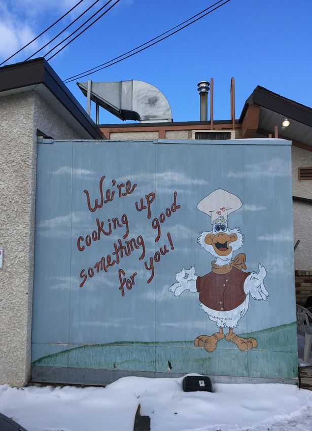
Rooster Town World: Remapping the Suburbs 97
with present-day historians, geographers, archivists, and long-time residents born in the
1940s or 1950s yields rumours and childhood memories that slip off and run away.
The ephemerality of the settlements itself is worth marking and dwelling on. Opacity
teaches, too—in this case, perhaps, about the specific workings of colonialism and the realities
of survival and resistance on the twentieth-century prairies. The Canadian state followed
a very different approach in colonizing Métis people than it took towards First Nations,
following a policy of non-recognition that intentionally failed to register the existence of
Métis communities.3 This approach helped Canadian powerbrokers not only to steal the
lands that twentieth-century Métis communities lived with, worked on, and cared for, but—
more easily than in the case of the so-called surrenders of First Nations reserve lands—to
steal the memory of the theft.4 At the same time, twentieth-century Métis communities
were so thoroughly demeaned by popular anti-Métis Canadian racial feeling that surviving
residents have sometimes been ashamed to speak about the settlements, even choosing not
to share the history with their children and grandchildren (Adams 1989). The necessity of
denying Métis identity and passing as white—one of the most workable survival strategies
available to many Métis people for much of the century—likely contributed to an enforced
silence about such communities. If Winnipeg’s Métis suburbs did not wish to be mapped,
recognized, registered, or displayed to the white public, who could blame them? They took
place outside of Canadian law, outside of Canadian respectability and might have been, in
the midst of the hostile order that engulfed them, in some sense fugitive settlements, artfully
evading detection by authorities. Such an ethic would, of course, have been sensible—the
road to scorched earth in Rooster Town was paved with state and journalistic attention.
…
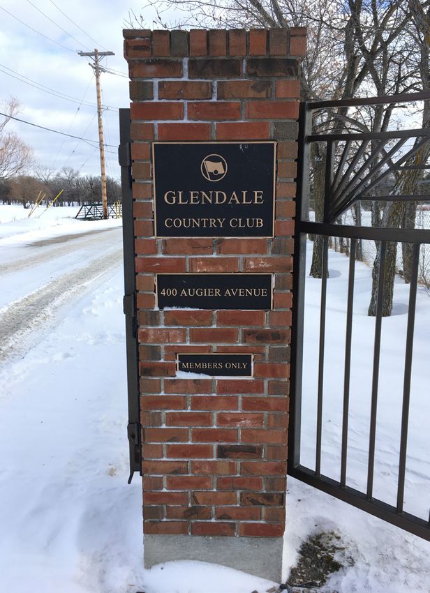
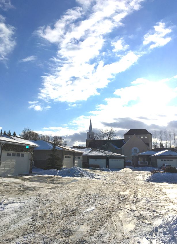
Still, there are traces. Tucked away between the Trans-Canada highway, Winnipeg’s Pe-
rimeter Highway, the Assiniboine river, and the Glendale Golf and Country Club, there
is a small neighbourhood, known as St. Charles, of small, good-quality, postwar bunga-
lows; several large four-story postwar apartment blocks (“Park Villa West”); a trailer park
(“Downs Village”); a small new development of larger stucco houses with two-car garages
(identical to those found in any new Winnipeg subdivision); and two or three old prewar
two-story brick houses with large porches. Along the river is a Catholic complex consist-
ing of St. Charles Church, built in 1905, and St. Charles Catholic School, founded in 1906.
Along the Trans-Canada there is a car-based area with an old Chicken Chef drive-thru, St.
Charles Motors used cars, several newer motels, auto-repair shops, and a park shielding the
neighbourhood from the highway. The area has the feel of a formerly rural area, oriented
toward the Assiniboine river, that, overtaken by the two big highways and the golf course,
has been transformed into a typical, modern suburban neighbourhood.
3 “Part of our poor documentation can be attributed to the lack of recognition attributed to Métis and
Halfbreeds, especially during the time of road allowances…Unlike First Nations whose reserves function as a
government recognized place for (most) members to go back to, save for the Alberta Métis settlements, Métis
and Halfbreeds do not have lands that function as administrative homes for our people.” (Parent, “From One
Colonization Road to Another?” 12-13).
4 “They steal/Then they take your memory of the theft,” (Shad, “Magic”).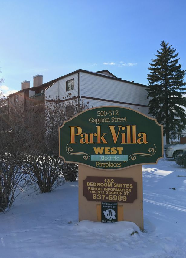
98     aboriginal policy studies

Clockwise: Glendale Golf and Country Club; Postwar apartments; Chicken Chef drive-thru; St.
Charles Church and subdivision.
Rooster Town World: Remapping the Suburbs           99

    From the 1820s to the 1940s or 1950s, this was the location of the Métis settlement
of Weak City (Barkwell 2009). The site was a buffalo crossing, according to Métis
genealogist Rosemary Morrisette-Rozyk, and later became a human crossing when a
ferry was installed across the Assiniboine River. The location was eventually surveyed as
River Lot 73. “In the early 1850s,” Irene Ternier Gordon writes, explaining the origins of
the settlement, “between 40 and 60 families of Métis buffalo hunters formed the original
Catholic community west of Sturgeon Creek” (Gordon, date unknown). The first St.
Charles Church, “A log chapel where the Métis hunters of the plains, contemporaries of
Cuthbert Grant and Louis Riel, gathered to worship,” according to historian Elizabeth
Maguet, was built in 1854 (Maguet 1978). Nineteenth-century residents of the settlement
worked in occupations other than hunting as well, including as midwives and as labourers
on barges for the Hudson’s Bay Company. The everyday lives of Weak City residents took
place in close connection to the rest of Red River (the Métis city that became known as
Winnipeg after the Canadian takeover)—some attended church events in St. Boniface,
for instance. As the fur trade gave way to export-agriculture and an urban merchant
economy, the people of Weak City combined wage work—as farmworkers for nearby
landowners, as ferry operators, and more—with more independent economic activities,
including cutting cordwood and small-scale pork and poultry production.
    Weak City was, at some point, considered to be a road allowance community (a
category of Métis settlement located on state-owned land reserved for future roadways)
according to Barkwell, which makes sense given the settlement’s proximity to the future
sites of the Perimeter Highway and Trans-Canada Highway. The question of who possessed
Canadian legal title to Weak City is not clear from MMF research, which makes reference
to some residents “squatting” in Weak City and to others who sold their land (Barkwell
2009). Weak City may have been a mix of “squatters” and “owners” from Canada’s point of
view—some Métis residents may have obtained Canadian title to the land via Métis scrip
allocated by the Manitoba Act or may have purchased land titles initially distributed to
non-Métis people. Other Métis residents may not have had Canadian title to the lands
they lived on, with these titles belonging to private speculators or to the state, as road
allowances for example. While there was plenty of city-owned, tax-forfeited land—the
Canadian legal status of the land under Rooster Town when its residents were evicted—
in St. Charles by the 1940s, it is not evident that this was the case for the land under
Weak City. Given what became of Weak City, it would make sense that many residents
did not possess title to their land. For many similar self-built working-class suburbs on
Turtle Island, the state’s refusal to provide residents with title to their lands was a key
precondition for large capitalist firms’ post-World War Two real estate development.
    At some point in the 1940s or 1950s, Weak City ceased to exist as such. Winnipeg
was expanding. Real estate developers followed expressway construction, grabbing land
and building modern suburbia. Weak City found itself in the crosshairs of two of the
city’s biggest new expressway projects and must have felt the brunt of suburban road
construction especially intensely. The St. Charles Ferry made regular trips across the
100 aboriginal policy studies
Assiniboine River until the day it was made obsolete by the new Perimeter Highway
bridge in 1959, coincidentally the same year that Rooster Town was evicted. Two of
Winnipeg’s biggest postwar subdivisions, Westwood and Silver Heights, were built in the
area (Winnipeg Free Press 1960). “By [1965] St. Charles had become overcrowded due
to a great influx of families into St. James-Assiniboia during the late 1950s and early
1960s,” the St. Charles Church History Committee writes, “The result was that the French
character of the parish was greatly diminished” (St. Charles Church History Committee
2004). Barkwell writes that, by the 1940s, most residents of Weak City had moved across
the Assiniboine River to Charleswood.
…
Our ability to remember places like Weak City, their contributions to urban history, and
their fundamental right to exist, has been hampered by a deliberate effort to erase them that
relies on notions of suburbs nullius: when we picture the old urban edge we tend to think
of empty space, or settler farmland, waiting to be turned into cookie-cutter subdivisions.5
Like the doctrine of terra nullius, this is a deliberately impoverished and dangerous misun-
derstanding of actual geographies and histories. As it turns out, pre-cookie cutter subur-
bia across Turtle Island was full of self-built, usually poor working-class settlements often
produced by people of colour, and often unsanctioned by the state (Harris 1996; Nicolaides
2002; Weiss 2004). Métis suburbia is an important part of this maliciously erased, conti-
nent-wide history. This wider suburban history, in turn, is part of a broader postwar history
of clearance that sacrificed innumerable thriving communities, including Black communi-
ties in Canada such as Africville in Halifax and Hogan’s Alley in Vancouver.
In similar, but not identical, ways as other insurgent suburban worlds, Métis
settlements made specific, indispensable contributions to history and geography,
including the history and geography of resistance to racial capitalism on Turtle Island.
In the aftermath of Canadian military conquest, the archipelago of Métis settlements
on the prairies functioned as an infrastructure of refuge and freedom against racial and
political persecution.6 Métis and non-status First Nations peoples creatively refused and
exceeded the spatial options officially available under Canadian apartheid, carving out
their own self-governed category of community that evaded both the authoritarianism
of Indian Reserves and the ruling bigotry of Canadian cities and towns. The settlements
kept long-held traditions of mutual aid and autonomy alive, including the capacity to
defy predatory Canadian state institutions—offering support to people who lost jobs or
spouses, community-based care for children when parents were unable to provide it, and
5 “Suburbs nullius” builds from the term “urbs nullius” coined by Glen Coulthard in Red Skin White Masks,
176.
6 “I weep at the heroics, the warmth, the wonderment of our lives, as our family struggled through neglect,
shame and shunning by the millions of others who had removed us from our lands, confined us to poverty,
forbidden us to sing our songs, then condemned us for how we lived.” (Maracle, introduction to the 2015
edition of Marilyn Dumont’s A Really Good Brown Girl).Rooster Town World: Remapping the Suburbs 101
protection from the RCMP (Campbell 2010, 15–16).7 Suburban locations gave residents
access to both urban labour markets and rural hunting, trapping, and harvesting economies.
Access to the latter enabled a level of autonomy in relation to capital that should be an
inspiration to all working people—including the power to refuse the workday as laid out
by bosses, to avoid relocating to distant job sites, and to prioritize “labour for self and
family” over “labour for the boss,” much to the consternation of both industrialists and
bureaucrats (Parent 2017, 36). It is difficult to imagine that the political life of twentieth-
century suburban settlements did not play a part in keeping the groundwork ready for
the Métis liberation movement of the 1960s, which in Manitoba among other things led
to the creation of the MMF in 1967. This is only a cursory picture—each aspect of which
deserves far more research—of what is erased by the suburbs nullius framing.
One of the effects of insisting on the historical importance of Métis suburbia and
exposing the doctrine of suburbs nullius is that it recasts the material production of the
modern suburbs and city centre alike—because the two were intimately intertwined by a
process of organized abandonment—as an explicit project of Indigenous dispossession.
This novel way of thinking about urban history generates a world of potential new
understandings about the present. For example, it is well known that suburbanization
contributed to upward mobility and enhanced economic security for the predominantly
white households who were able to obtain state-subsidized ownership of newly-
constructed homes; but suburbanization almost certainly contributed to downward
mobility and economic precarity for Métis and non-status First Nations households who
lost homes, livelihoods, and networks of support and mutual aid as a result. The impact of
suburbanization on the inner city is usually explained as a so-called hollowing-out effect;
but there is evidence that suburbanization also filled in the inner city with Indigenous
households newly displaced from the urban edge (Burley 2013, 4). Oppressive state
management and policing of the Indigenous inner city is often justified with recourse to
dehumanizing narratives that play well in the suburbs; what if those kinds of narratives
were built into the meaning of postwar suburban life on the prairies to begin with?
The politics and identities activated by modern suburbia are particularly interesting
to consider. For example, it is often asserted—but seldom rigorously explained—by
historians of the Canadian prairies that postwar suburbanization contributed to the
breakdown of “ethnic barriers” among European-descended peoples, amounting to what
elsewhere has been referred to as a “passage to whiteness” for some non-Anglo-Saxon
Protestants (Loewen and Friesen 2009, 78). Mainstream histories of immigration do not
usually place this process in its proper settler-colonial context but it is absolutely crucial
to do so. Canadian cities have always been Indigenous spaces and urban restructuring
in Canada always takes place in relation to Canadian settler colonialism. By the mid-
twentieth century, one of the defining partitions between Anglo-Saxon Protestants and
7 “We had no laws. We just had our own laws.” (Margaret Jaffray, in Mike Evans, et al, What it is to be a Métis,
139).102 aboriginal policy studies
other non-Indigenous peoples on the Canadian prairies had been the matter of who would
be granted settler status via title to stolen Indigenous lands in the form of a profitable
homestead and who would end up landless, forced into working for a boss and paying
rent to a landlord in the city (while still occupying a higher rung in the regional racial
hierarchy than Indigenous peoples who were systematically turned away by urban bosses
and landlords). For some property-less non-Indigenous peoples, suburbanization would
have been an opportunity to acquire Indigenous lands, and in some cases to directly
replace and revitalize Indigenous communities—in other words, to become a bona fide
settler—that had thus far been denied to them. What better way to become white or to
cultivate feelings of racial and national belonging in Canada?
The postwar history of Weak City might contribute something to an understanding
of the latter process. In 1946, the golf course next door to Weak City was purchased
and converted into Winnipeg’s first “Jewish Country Club” by a consortium of Jewish
businessmen and professionals barred from joining the city’s Anglo-Saxon Protestant
country clubs by openly anti-Semitic membership policies. The club’s founding members
were not particularly interested in golf—most had never played the game—but wanted
to create a place for gathering, making connections, and doing business suited to the
growing number of prosperous Jewish families in the city. The club’s founders priced
voting memberships at $500-$1,000 ($7,125-$14,250 in 2019 dollars) annually but sold
hundreds of non-voting annual memberships for $60 ($855 in 2019 dollars), making the
club accessible to a wider range of Jewish workers. Membership grew steadily through
the 1950s, and in 1954 the club expanded onto thirteen acres of “undeveloped land”
directly to the east of the golf course (Remis 1996, 12). Nothing in this history implicates
the Glendale Golf and Country Club in the displacement of Weak City, but the fact
remains that Winnipeg’s upwardly mobile Jewish community was a major participant and
beneficiary of the postwar redevelopment of St. Charles that coincided with Weak City’s
dissolution. Regardless of any conscious aspiration to identify as white, the community
that hatched the Glendale Golf and Country Club benefitted from a process of urban
improvement—tied to longstanding racial structures of settlement in Canada—in
which golf courses and country clubs, coded as white spaces, are positioned as higher
and better uses of land than self-built Métis communities or other Indigenous spaces.
The racial calculus of the real estate developers financing Westwood and Silver Heights
certainly valued a golf course—even a Jewish-owned one—as a marketable amenity over
a Métis settlement where residents still produced their own food, chopped firewood, and
renewed a traditional connection to the land that far exceeded Canada’s both legally and
temporally. Structurally speaking, the case of the Glendale Golf and Country Club points
to some of the ways that postwar prosperity for Winnipeg’s non-Anglo-Saxon Protestant
communities took place on suburban spatial foundations that were forged by some degree
of neglect, exclusion, displacement, and dispossession of preexisting Métis suburbs.
…Rooster Town World: Remapping the Suburbs 103 The history of Métis and non-status First Nations suburbs deserves far more care and at- tention than historians and geographers have given it. Rebuilding a new collective mem- ory of the Indigenous suburbs, however, needs to go beyond memorializing or, as geogra- pher Clyde Woods wrote, conducting social science “autopsies.” In her 2013 book, Mark My Words: Native Women Mapping Our Nations, Tonawanda Seneca geographer Mishauna Goeman advocates a process of “remapping,” that Goeman describes as, “not just about regaining that which was lost and returning to an original and pure point in history, but in- stead understanding the processes that have defined our current spatialities.” Perhaps, in this spirit, remapping the suburbs can be a way of adding to a reservoir of knowledge, feeling, and counter-planning to be drawn from—as in the case of the 2017 Rooster Town Block- ade—as we resist new waves of racial capitalist dispossession and build less forgetful cities. Author’s acknowledgments Thank you to Chris Andersen, Lawrie Barkwell, Merissa Daborn, Mary Jane McCallum, David Parent, Adele Perry, Evelyn Peters, and the faculty and students at the University of Alberta Faculty of Native Studies for engaging with this work at various stages. I would like to acknowledge the financial support of the Grant Notley Memorial Postdoctoral Fellow- ship at the University of Alberta.
104    aboriginal policy studies

References
Adams, H. 1989. Prison of Grass. Markham: Fifth House Publishing.
Artibise, A. 1977. Winnipeg: An Illustrated History. Toronto: James Lorimer & Company.
Barkwell, L. 2009. Weak City, Manitoba: Métis Road Allowance Community. Winnipeg:
      Louis Riel Institute.
Brand, D. 2002. Thirsty. Toronto: McLelland & Stewart.
Burley, D. 2013. “Rooster Town: Winnipeg’s Lost Métis Suburb, 1900–1960.” Urban History
        Review XLII, no.1: 3 –26.
Campbell, M. 2010. Stories of the Road Allowance People. The Revised Edition. Saskatoon:
     Gabriel Dumont Institute.
Coulthard, G. 2014. Red Skin White Masks: Rejecting the Colonial Politics of Recognition.
      Minneapolis: University of Minnesota Press.
Evans, M. et al. 2007. What it is to be a Métis: The Stories and Recollections of the Elders of
       the Prince George Métis Elders Society. Prince George, BC: UNBC Press.
Goeman, M. 2013. Mark My Words: Native Women Mapping Our Nations. Minneapolis:
     University of Minnesota Press.
Gordon, I.T. (n.d.). History of St. Charles Church. Accessed September 15, 2018. http://
      www.saintcharles.ca/home/about-st-charles/our-history-2
Harris, R. 1996. Unplanned Suburbs: Toronto’s American Tragedy, 1900 to 1950. Baltimore:
        Johns Hopkins University Press.
Loewen, R., and Friesen, G. 2009. Immigrants in Prairie Cities: Ethnic Diversity in Twentieth-
      Century Canada. Toronto: University of Toronto Press.
Maguet, E. 1978. “St. Charles…A history worth preserving.” Text of a commentary for
      Information Radio. CBC Winnipeg, February 23, 1978.
Nicolaides, B. 2002. My Blue Heaven: Life and Politics in the Working-Class Suburbs of Los
       Angeles, 1920–1965. Chicago: University of Chicago Press.
Omi, M., and Winant, H. 1994. Racial Formation in the United States. New York: Routledge.
Peters, E., Stock, M., and Werner, A. 2018. Rooster Town: The History of an Urban Métis
        Community, 1901–1961. Winnipeg: University of Manitoba Press.
Rooster Town World: Remapping the Suburbs 105
Parent, D. 2017. “From One Colonization Road to Another? Everyday Memories of
the Social and Economic Conditions in Minnewakin, Stone Lake, and Lundar,
Manitoba, 1940–1960.” Master’s Thesis, University of Alberta Native Studies.
Remis, L. 1996. Glendale Golf and Country Club Anniversary Yearbook 1946–1996.
Roy, A. 2005. Islands in History and Representation: Literature and Culture in British India
1822–1922. New York: Routledge.
Shad. 2018. Magic. A Short Story About War. Secret City Records.
St. Charles Church History Committee. 2004. St. Charles Catholic Church, 1854–2004.
Weiss, A. 2004. Places of Their Own: African American Suburbanization in the Twentieth
Century. Chicago: University of Chicago Press.
Winnipeg Free Press. 1960. Residential Construction Ranks as One of Main City Industries.
Winnipeg Free Press, September 19, 1960.You can also read