Rethinking the Public Realm: Behaviour Settings in Malaysian Cities
←
→
Page content transcription
If your browser does not render page correctly, please read the page content below
IOP Conference Series: Materials Science and Engineering

PAPER • OPEN ACCESS

Rethinking the Public Realm: Behaviour Settings in Malaysian Cities
To cite this article: Robert Powell et al 2019 IOP Conf. Ser.: Mater. Sci. Eng. 471 092087

View the article online for updates and enhancements.

                                This content was downloaded from IP address 176.9.8.24 on 25/09/2020 at 18:06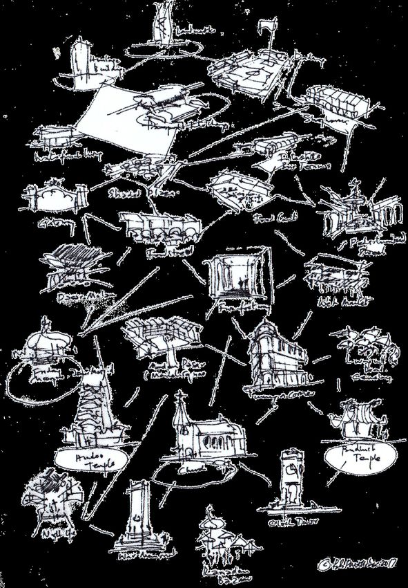
WMCAUS 2018                                                                                IOP Publishing
IOP Conf. Series: Materials Science and Engineering 471 (2019) 092087 doi:10.1088/1757-899X/471/9/092087

Rethinking the Public Realm: Behaviour Settings in
Malaysian Cities

                      Robert Powell 1, Camelia May Li Kusumo 1, Sucharita Srirangam 1
                      1
                       School of Architecture, Building and Design, Taylor’s University Lakeside Campus,
                      47500 Subang Jaya Selangor, Malaysia

                      robert.powell@taylors.edu.my

                      Abstract. The most extraordinary and satisfying spaces in cities and towns throughout the
                      world have often been created, not by city planners, urban-designers/architects and engineers,
                      but by communities, working within a vernacular tradition. Since the mid-20th century
                      academics, researchers and practitioners have been attempting to define, measure and replicate
                      these many delightful urban spaces but in general, despite the plethora of academic papers and
                      books on the subject, the public realm in many Asian cities is rapidly declining as they
                      succumb to the dominance of the automobile. We know that cities are afflicted and the
                      question arises … how can professional designers of cities in the 21st century create a public
                      realm that has uplifting qualities? The paper details a Literature Review as the first step in a
                      research project that aims to create a framework for liveability/ walkability in relation to
                      Malaysian waterfront cities. The Royal Town of Klang is selected as a suitable case study.

1. Literature Review
The first part of this paper traces the extensive literature on the public realm, mostly from Western
sources. In 1961, Jane Jacobs succinctly recorded the post-WWII ‘erosion of cities’ and ‘the attrition
of automobiles’ in The Death and Life of Great American Cities, [1]. The book marked a watershed
and predicted many of the problems now endemic in Asian cities.

    Lynch’s 1960 book Image of the City, published one year earlier has been hugely influential in our
understanding of the city, [2]. Lynch identifies five key elements necessary to form a legible image of
a city. Lynch’s analysis records subjective impressions as well as physical objects. Lynch came to the
conclusion that we form the image of the city using five elements - Landmarks. Paths, Edges, Nodes
and Districts. Landmarks are singular elements for their symbolism. They need not be built objects. A
landmark could be a Mosque, it could be a huge tree, or it could be a small shrine or a bridge. Paths
are routes that possess some singular spatial quality – could be a street, a boulevard, a railway line, a
back lane. Nodes are strategic points in the city, they are usually at the meeting of paths and generally
there is a concentration of activity and may be associated with a landmark. Districts could be
commercial, institutional district, residential district. Edges are the boundaries between districts.
Lynch recognised that the city is perceived not as static objects but as a continuum. The book is useful
in articulating how a city is made legible to its users, aiding in orientation and way finding

  Gordon Cullen’s 1961 book Townscape [3] urged urban designers to look carefully at the city as
we use it in our daily life. It explains in simple language the effect of buildings and urban spaces upon

              Content from this work may be used under the terms of the Creative Commons Attribution 3.0 licence. Any further distribution
              of this work must maintain attribution to the author(s) and the title of the work, journal citation and DOI.
Published under licence by IOP Publishing Ltd                          1
WMCAUS 2018                                                                                IOP Publishing
IOP Conf. Series: Materials Science and Engineering 471 (2019) 092087 doi:10.1088/1757-899X/471/9/092087

their users and illustrates spatial ploys – including the creation of enclaves and the sense of enclosure
that is a vital component of the public domain. The most important lesson derived from Cullen is the
notion of ‘Serial Vision’. Cullen describes serial vision as a sequence of revelations. A city is not a
static experience but it gradually unfolds as you walk through it. Cullen’s ‘Serial Vision’ can be
recorded but can it be measured and the spatial experience be reproduced?

   From 1960 onwards other writers have addressed the problem of erosion of the urban realm.
Nevertheless, in the decades since, many cities have succumbed to the dominance of private vehicles
and consequently have become unwalkable. In the 1960s the UK was grappling with the negative
impacts of increasing traffic levels on towns and cities. Colin Buchanan wrote presciently of the
problem in Traffic in Towns published by the Ministry of Transport and subsequently as a soft back
book [4]. In 1967 Edmund Bacon contributed ideas from Pittsburgh on the ‘Design of Cities’ (Bacon
1967) [5].

    Most architects and urban designers will be familiar with ‘A Pattern Language’ - compiled by
Christopher Alexander and his colleagues at the Center (sic) for Environmental Structure at the
University of California, Berkeley, [6]. The seminal book was published in 1977 together with a
companion volume, The Timeless Way of Building, [7]. Of particular interest are the patterns that
specifically relate to urbanism. A Pattern Language, researched by Alexander et al over a period of
eight years, describes ‘timeless’ patterns, supported by drawings, photographs and charts with insights
into methods of designing built form at every scale, from entire regions, to cities, neighbourhoods, and
streets. Alexander’s Pattern Language touches upon the deep emotions that ‘make people feel alive
and human’. However, the question arises how can the Urban Designer reproduce the patterns in
practice? Recognising this, in 1987 Alexander answered the question with another publication A New
Theory of Urban Design, [8] that attempts to replicate the process by which cities developed
organically in the past. To discover the kinds of laws needed to create a growing whole in a city,
Alexander proposes a preliminary set of seven rules derived from the Pattern Language and which are
consistent with the real demands of urban development. Yet the new theory does not measure the
impact of the patterns and relies very much on intuition in their application. Another influential
urbanist Rob Krier in his book ‘Urban Space’ [9] examined the erosion of urban space years and
assembled a selection of successful urban spaces, usually experienced in combinations of streets and
squares, but the spaces are not critically analysed.

   In 1984 Bill Hillier produced a theory of Space Syntax [10] described as, “a new method for the
modelling of cities. He chronicles some memorable spaces in his tome, which has led to a new,
scientific theory of the city. Space Syntax looks at the precise nature of the physical city by
modelling, in the first instance, the network of spaces – streets, roads, boulevards, alleys, and so on –
that is the biggest thing in the city and in effect holds it all together. Because of its ability to synthesise
complex patterns of urban data on the basis of a functionally intelligent analysis of spatial networks,
Space Syntax is increasingly being used as a master-planning tool. Space Syntax is then a space-based
and evidence-based way of bringing architecture, urban design, planning and transport planning
together through spatial modelling, in what some commentators call ‘strategic urban design’, [10].

   The forces that shape cities are examined in Spiro Kostov’s classic volumes The City Shaped and
The City Fashioned [11] while Clifford Moughtin’s book, Urban Design: Streets and Squares [12]
and Alan Jacob’s Great Streets [13] chronicle memorable urban spaces. The publications are useful in
defining the qualities of liveable streets. A reaction to the decline of cities in the 1980s in the USA
grew in the form of New Urbanism, an urban design movement headed by Andre Duany and Elizabeth
Plater-Zyberk [14], which promoted walkable neighbourhoods containing a wide range of housing and
job opportunities. New Urbanism encompasses basic principles such as traditional neighbourhood
design and transit-oriented development [15]. Jeff Speck, who has collaborated with DPZ is the author

                                                       2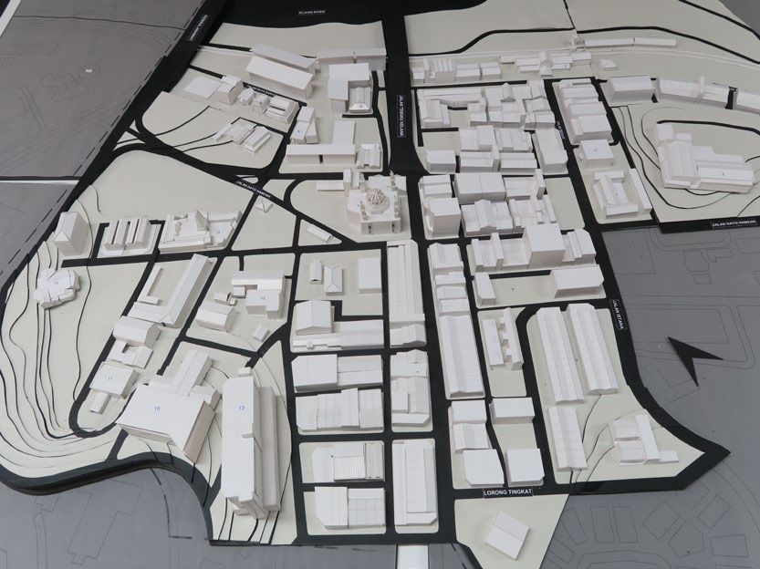
WMCAUS 2018 IOP Publishing
IOP Conf. Series: Materials Science and Engineering 471 (2019) 092087 doi:10.1088/1757-899X/471/9/092087
of Walkable City [16] published in 2012 that highlights the advantages of a pedestrian-friendly
environment.
Ideas can be gleaned from other writers such as Jahn Gehl who in his 1984 book Life Between
Buildings [17], looks at towns and cities in terms of what makes them enjoyable places in which to
live and how this can be facilitated. Gehl is one of the most influential urban thinkers and practitioners
of our time. He is concerned with walking distances, walking routes, spatial sequences, movement
around the edge of spaces, areas for standing and staying in and most important opportunities for
sitting. They are included in Jan Gehl and Lars Gemzoe’s survey of Usage Patterns described in
Public Spaces: Public Life (1996) [18]. Following the publication of Cities for People (2010) [19]
Gehl has also produced a downloadable free tool kit to assist in measuring the quality of the urban
realm as an extension of the book entitled How to Study Public Life (2013) [20].
2. Behaviour Settings
One other potentially useful research methodology is suggested by Jon Lang’s 1974 publications on
‘Designing for Human Behaviour [21] which examines the relation between urban space and the
behavioural sciences. Another publication by Jon Lang, Urban Design: The American Experience
[22] draws upon the behavioural sciences to define ‘Behaviour Settings’ in the city. Who could not
agree with Lang’s assertion that, ‘the problem with most urban design paradigms is that they represent
an over-simplified version of life – the richness of behavioural and aesthetic nuances that make a
culture what it is - gets left out … physical forms do not in themselves create urbanity. Urbanism,
within a cultural sphere, can be defined in terms of the richness of behaviour settings that people
inhabit in the course of their everyday and special occasions lives, in short urbanism results from life-
events’, [23].
The application of behaviour setting theory in Urban Design is derived largely from work by
the eminent ecological psychologist Roger Barker in the late 1960s. Barker’s work connects behaviour
and physical features of ordinary - and those not-so-ordinary urban settings. ‘A behaviour setting is
said to exist at the interface between a standing pattern of behaviour and the milieu (environment),
wherein the behaviour is happening in the 'milieu', and the 'milieu' in some sense matches the
'behaviour', [24].
According to Barker conducting a behaviour setting survey consists of the measurement of
eleven key descriptive attributes: Occurrence, Duration, Population, Occupancy Time, Penetration,
Action Patterns, Behaviour Mechanisms, Richness, Pressure, Welfare and Local Autonomy. These are
explained at length in Roger Barker’s book Ecological Pysychology [25].
Behavioural Settings in many ways are similar to the Pattern Language approach developed
by Christopher Alexander [26] but they are grounded in measurement in addition to keen observation.
In response to the Literature Review the intention is to employ a hybrid method of conducting a
survey in the urban context of Klang leading to a Strategic Master Plan. As a prelude an inventory has
been prepared of 75 Behaviour Settings (Patterns) observed in four Malaysian waterfront settlements –
Kuala Lumpur, Penang, Kota Kinabalu and Klang, over a period of two years. The 75 behavioural
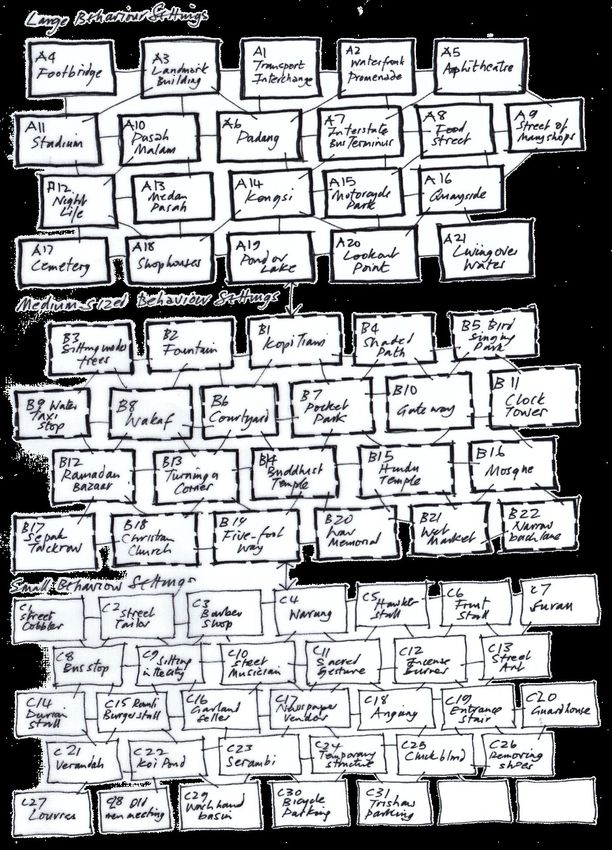
settings are grouped roughly in order of magnitude of scale i.e. Large Behaviour Settings, Mediums-
size Behaviour Settings and Small Behaviour Settings. Large behaviour settings encopmpass several
medium-sized and small behaviour settings while small behaviour settings typically ‘nest’ within
larger behaviour settings. Combined together, the behaviour settings encourage walkability in the
urban realm.
3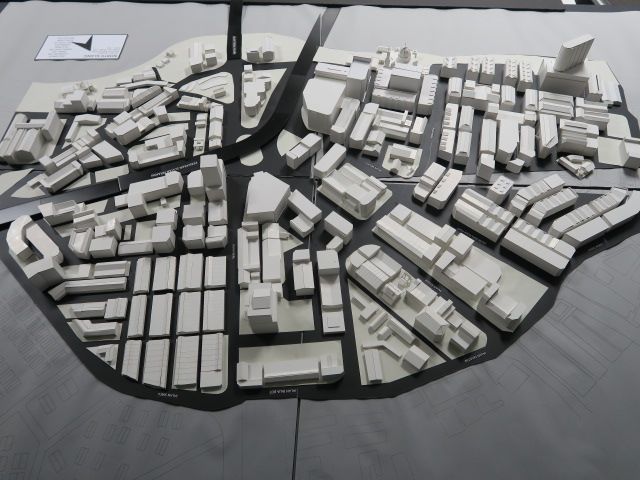
WMCAUS 2018                                                                                IOP Publishing
IOP Conf. Series: Materials Science and Engineering 471 (2019) 092087 doi:10.1088/1757-899X/471/9/092087

                             Figure 1. Three scales of Behaviour Settings

                                                    4
WMCAUS 2018 IOP Publishing
IOP Conf. Series: Materials Science and Engineering 471 (2019) 092087 doi:10.1088/1757-899X/471/9/092087
Figure 2. Twenty-five of the behaviour settings are illustrated graphically. All have a temporal quality
5WMCAUS 2018 IOP Publishing
IOP Conf. Series: Materials Science and Engineering 471 (2019) 092087 doi:10.1088/1757-899X/471/9/092087
3. The Malaysian Dilemma
In 1984 the centre of Kuala Lumpur at the confluence of the Klang and Gombak Rivers was a place
where one could walk easily. The tallest building was the Dayabumi tower designed by Kington Loo
of BEP and MAA Architects. In 1985 a study on the so-called Golden Triangle Area was convened
during the period when Dr. Ken Yeang was President of Pertubuhan Akitek Malaysia. Yeang initiated
collaboration between PAM, Dewan Banderaya KL, the Aga Khan Program for Islamic Architecture
at Harvard and MIT, ITM and UTM. Among the problems identified by the group were discontinuity
at ground level, an absence of public places and alienation from the past. Several schemes were
presented for the future city. Almost all envisaged Kuala Lumpur as a walkable city, connected to
nature, [27].
The Tropical Verandah City [28] published by Ken Yeang in 1987 portrayed a vision of Kuala
Lumpur as a Garden City linked by covered walkways and verandahs. It is one of the few publications
to have addressed the challenge of the climate in Malaysia. Thirty years have passed and the book is
still relevant indeed more so as we seek to make tropical cities walkable and reduce the impact of the
automobile. The book contained ideas for landscaped linkages, gardens and parks including formal
terraced promenades with water fountains, informal tropical gardens, public squares, landscape in-
between building blocks with linked verandahways. A network of verandahs and covered pedestrian
walkways was proposed with the overall idea of consolidating the historical, cultural and architectural
heritage of the city.
What happened to the city between 1987 and 2017? The idea of pedestrian linkages has gone.
Highways strangle the city and the suburbs. It is utterly insane with shopping malls and 'integrated
private cities' such as Sunway linked by highways, overpasses and elevated flyovers. There is zero
'public realm'. Much of the public space is now privatised. Walking in the city is a nightmare. There is
no provision for pedestrians who are forced to walk along highways. Only the poor (and tourists)
walk. Even when pedestrian paths are provided they are not designed well, they frequently do not join
– up or they are appropriated for motorcycle parking. Other public spaces are uninhabitable in the heat
of the day.
Cities in Malaysia underwent a major change in the 1980s and 1990s. This can, in part, be
attributed to the policies of Dr. Mahathir Mohamad, Malaysia’s Prime Minister from 1981 to 2003. Dr
Mahathir’s vision for Malaysia to become a developed nation by 2020 saw the vast expansion of the
country’s highway network; the planning, in 1993, of the new Federal capital of Putrajaya 35 km to
the south of Kuala Lumpur; the completion of a new international airport (KLIA), 55 km south of the
capital, in 1998; the closure of the rail link between Singapore and KL and the launch of the North-
South Highway in 1981 followed by other privately funded highways in the Klang valley; the
completion of the Penang Bridge in 1985; the launch of the Multi-Media Super Corridor (MSC) in
1996; and much more, [29].
In 1983 the Proton Saga, the first home-produced car was launched – a low cost vehicle that made
car- ownership possible for a large proportion of the population. In short, Malaysia became a nation of
car owners, middle-income families increasingly living in so-called ‘integrated townships’ and
commuting on a daily basis to work and shopping malls. Kuala Lumpur saw massive changes as it was
retrofitted to meet the huge growth in ownership of private vehicles.
Urbanity in KL and other Malaysian cities has seriously declined with the growth of vehicle
ownership. There is an increasing dependency on private cars with a 63% increase in car ownership
between 2000 and 2009, [30] but the last decade has also seen a surge of interest in walkable cities,
motivated by environmental, health, economic and community goals. Numerous publications have
emerged from Malaysian academics in response to the problem. Some writers have focussed on
factors such as the optimum distance for walking in tropical climate conditions, the walking
experience and location of community facilities [31]. Other writers focus upon the attraction of
walkable cities for tourism [32]. Inclusivity and equality in the context of women’s mobility forms the
focus of other studies on walkability in the Malaysian context, [33]. Research at the University of
Malaya on Sensory Experience is also informative, [34].
6WMCAUS 2018 IOP Publishing
IOP Conf. Series: Materials Science and Engineering 471 (2019) 092087 doi:10.1088/1757-899X/471/9/092087
In spite of the growing concern about the erosion of the urban realm there are very few examples of
successful interventions, a gap exists between academic studies and implementation. This mirrors the
concerns of academics in a USA study who conclude “The focus on assessing the claims and
assumptions, the pros and cons, and the unintended effects of the walkable neighborhood is testament
to the new level of rigour proposals about the built environment are now subjected to. We see this as a
positive gain, but wonder whether there will be a time, perhaps in the not too distant future, when
research will move beyond assessment of impacts and move toward the subject of implementation”,
[35].
The absence of Government initiatives to arrest the decline of cities has resulted in the expansion of
‘Tactical Urbanism’, a term used to describe the transformation of cities by incremental, low-cost
improvements that allows a wide range of actors to participate in the process of street design in real
time. One erudite proponent of this approach is Mike Lydon in the book Tactical Urbanism: Short
term Action for Long-Term Change, [36]. Tactical Urbanism has also been referred to as ‘pop-up
urbanism’ or ‘guerilla urbanism’.
4. The Royal Town of Klang
Klang was an ancient settlement on the west coast of Malaysia that evidently existed as early as the
Bronze and Iron Age, [37]. However, when Bugis settlers arrived from Surabaya in the early 18th
century and set up a Sultanate in 1766 they preferred to operate out of Kuala Selangor to the north. Yet
Klang became important as the gateway for the export of tin and by 1857 had surpassed Kuala
Selangor. Indeed by 1872 Klang was a flourishing settlement and it became the capital of Selangor
State when the British administration was set up under James Guthrie Davidson, the first Resident.
In 1880 Kuala Lumpur replaced Klang as the state capital. That said, Klang continued to be the
main port for export of tin and import of oil, rice, tobacco, salt, opium etc. The town was very
successful although its importance declined somewhat with the establishment of Port Swettenham in
1901, at the very mouth of the Klang River. In 1908 a bridge was constructed joining North and South
Klang and the town proved resilient to change as it became a centre for agricultural produce in the
form of pepper, sago, gambier, coffee and subsequently pineapple and rubber (from 1928).
Figure 3. Scale model of North Klang
After Independence in 1957 Klang was the premier industrial site in Malaysia but increasingly
faced competition from Petaling Jaya and more recently from Shah Alam, [38]. This has resulted in
7WMCAUS 2018 IOP Publishing
IOP Conf. Series: Materials Science and Engineering 471 (2019) 092087 doi:10.1088/1757-899X/471/9/092087
the rapid decline of Klang since the 1980s. Traffic congestion is today a major problem in the town
and contributes to the problem of walkability. There are other problems include an ageing population,
periodic flooding, water pollution, decline of infrastructure, decaying properties etc., accompanied by
lack of economic opportunities, unemployment and gangsterism.
In Klang there has been a rise in ‘Tactical Urbanism’ as described above i.e. bottom–up initiatives
by the community such as the Klang City Rejuvenation Team (KCR) formed by the Chinese, Indian
and Malay Chambers of Commerce, assisted by Think City (a subsidary of Khazanah National Bhd).
Initiatives include an annual Heritage Festival, a Street Food Festival, Festival Tang Lung, Street Art
and a Heritage Walk, all intended by default to create the nested ‘Behavioural Settings’ described
above.
Figure 4. Scale model of South Klang
5. Conclusion
While there are numerous publications on resilient cities and sustainable cities there are very few
publications in the 21st century that focus upon the rapidly growing cities in Southeast Asia, and
specifically in Malaysia, as places for people. This has prompted a group of researchers at Taylor’s
University to turn their attention to the issue of regeneration of declining Malaysian (waterfront) cities
using Klang as a case study. The first paper in this research project Towards a Malaysian Pattern
Language A Mosaic of Subcultures was presented by the author at ACE 2017, [39]. The Taylor’s
University research team have subsequently formed links with KCR and Think City.
It is evident from the preceding literature review that while much has been written about reclaiming
the urban realm both globally and in the context of Malaysian cities, there is a gap between academic
publications and positive outcomes. Short-term initiatives by the community, although welcome, are
not sustainable in the long run without an in-depth study to understand the socio-cultural environment
of Klang leading to the development of a Strategic Master Plan with full support from the local
municipality. It is the aim of the research team to produce such a plan. In-depth studies will interrogate
aspects of behavioural settings, patterns language and space-syntactic measurement. The plan will
connect with and integrate the existing tactical urbanism.
References
[1] Jacobs, Jane, The Death and Life of Great American Cities, Random House, 1961, pp 352-385.
[2] Lynch, Kevin, The Image of the City, 1960.
[3] Cullen, Gordon, Townscape, Butterworth Heinemann, 1961.
8WMCAUS 2018 IOP Publishing
IOP Conf. Series: Materials Science and Engineering 471 (2019) 092087 doi:10.1088/1757-899X/471/9/092087
[4] Buchanan, Colin et al, Traffic in Towns, Penguin, London 1964.
[5] Bacon, Edmund, Design of Cities, 1967
[6] Alexander, Christopher et al, A Pattern Language, Oxford University Press, 1977.
[7] Alexander, Christopher et al, The Timeless Way, Oxford University Press, 1977.
[8] Alexander, Christopher et al., A New Theory of Urban Design, Oxford University Press, USA.
1987.
[9] Krier. Rob, Urban Space, Academy Editions, 1979
[10] Hillier, Bill, The Social Logic of Space, Cambridge University Press, 1984.
[11] Hillier, Bill and Tim Stonor, ‘Space Syntax: Strategic Urban Design’, in Future of Urban Space
and Humanity, City Planning Review, City Planning Institute of Japan, 2010.
[12] Kostov, Spiro, The City Shaped, Bullfinch Press, 1991.
[13] Moughton, Clifford, Urban Design: Streets and Squares, Elsevier, 1992.
[14] Jacobs, Alan, Great Streets, MIT Press, 1993.
[15] Duany, Andre and Elizabeth Plater-Zyberk, The New Civic Art: Elements of Town Planning,
Rizzoli, New York, 2003.
[16] Duany, Andre and Elizabeth Plater- Zyberk, The Smart Growth Manual, McGraw Hill, New
York, 2009.
[17] Speck, Jeff, Walkable City, Farrar Straus and Giroux, 2012.
[18] Gehl, Jan, Life Between Buildings, Van Norstrand, 1982
[19] Gehl, Jan, Public Spaces: Public Life, Danish Architectural Press and Royal Danish Academy
of Fine Arts, 1996.\
[20] Gehl, Jan, Cities for People, Island Books, 2010.
[21] Gehl, Jan and Birgitte Svarre, How to Study Public Life, Island Press, 2013.
[22] Lang, Jon, Designing for Human Behaviour, John Wiley, 1974.
[23] Lang, Jon, Urban Design: The American Experience, Van Nostrand Reinhold, New York, 1994.
[24] Lang, Jon, “Exploring Urban Design Paradigms’, in MUDD Programme Overview, Faculty of
the Built Environment, The University of New South Wales, Australia, 1998.
[25] Barker, Roger G.. Ecological Psychology: Concepts and methods for studying the environment
of human behaviour. Stanford, CA: Stanford University Press. 1968.
[26] Alexander, Christopher, A Pattern Language, ibid.
[27] Kasi, P., Penny Gurstein and John Dale (Eds), KL’s Golden Triangle; Ideas, Issues and
Alternatives (sic), PAM Kuala Lumpur, July 1985.
[28] Yeang, Ken, The Tropical Verandah City, Longmans. Kuala Lumpur, 1987.
[29] Mohamed, Esa, ‘4th Decade: The Mega Projects’, in Views Reviews Interviews (Ed. David
Teh), Merdeka Jubilee Architecture Symposium. PAM, 2017.
[30] Shuhana Shamsuddin, NorRasyiqah Abi Hasan and Siti Fatimah Ilani Bilyamin, Walking
Environment in Increasing Livability of a City, ASEAN Conference on Environmental-
Behavioour Studies, Bangkok, Thailand, July 2012.
[31] Diyanah Inani Azmi and Hafizah Abdul Karim, A Comparative Study of Walking Behaviour in
Community Facilities in Low-Cost and Medium Cost Housing, Asia Pacific International
Conference on Environmental Behaviour Studies, Famagusta, North Cyprus, December
2011,
[32] Norsidah Ujang and Zulkifri Muslim, Walkability and Attachment to Tourism Places in the City
of Kuala Lumpur, Malaysia, Athens Journal of Tourism, March 2014.
[33] Y A S Harumain, N F AZMI and S M Yusoff, Assessing Elements of Walkability in Women’s
Mobility, Journal of the Society of Automative Engineers Malaysia, Volume 1 Issue 3, pp
208-215, September 2017.
[34] Sherina Rezvani, Amirhosein Ghaffarianhoseini & Norhaslina Hassan, ‘Why do people tend to
walk in certain places? A review of Urban Social and Physical attributes affecting
pedestrian’s sensory experience’, 3rd NZAAR International Conference on Urban Design
and City Planning (UDCP 2017), Kuala Lumpur, Malaysia. 2016.
9WMCAUS 2018 IOP Publishing
IOP Conf. Series: Materials Science and Engineering 471 (2019) 092087 doi:10.1088/1757-899X/471/9/092087
[35] Talen, Emily and Julia Koschinsky, The Walkable Neighbourhood: A Literature Review.
International Journal of Sustainable Land Use and Urban Planning, ISSN 1927-8845, Vol 1
No.1, pp 42-63, 2013.
[36] Lydon, Mike and Tony Garcia, Tactical Urbanism: Short-term Action for Long-term Growth,
Island Press, 2015.
[37] Gullick, J. M., ‘The Fall and Rise of Klang’, JMBRAS, Vol. 79, Part 1, 2006, pp1-26.
[38] Khoo, Kay Kim, Klang District and Town: History and Historical Sources, Kekal Abadi 8(2),
June 1989.
[39] Powell, Robert, Towards a Malaysian Pattern Language: Mosaic of Subcultures, 5th Annual
International Conference on Architecture and Civil Engineering, (ACE2017), Global Science
and Technology Forum, Singapore, May 2017.
10You can also read